A Strange Beast
Fire season runs nearly year-round these days, with some part of North America burning at almost any time. The U.S. Southwest can light up as early as January; the coldest northern climates get their turn right before summer, when the freeze-dried grass and trees are exposed by springtime snowmelt. Smoke has become just another weather hazard to plan around, and the pilots of BackcountryPilot.org have learned from hard-earned experience how to fly in it—a strange and unpredictable beast—sharing their approaches in past forum discussions.
Here are 9 things they learned the hard way.
1 Don't Trust What You See from the Ground
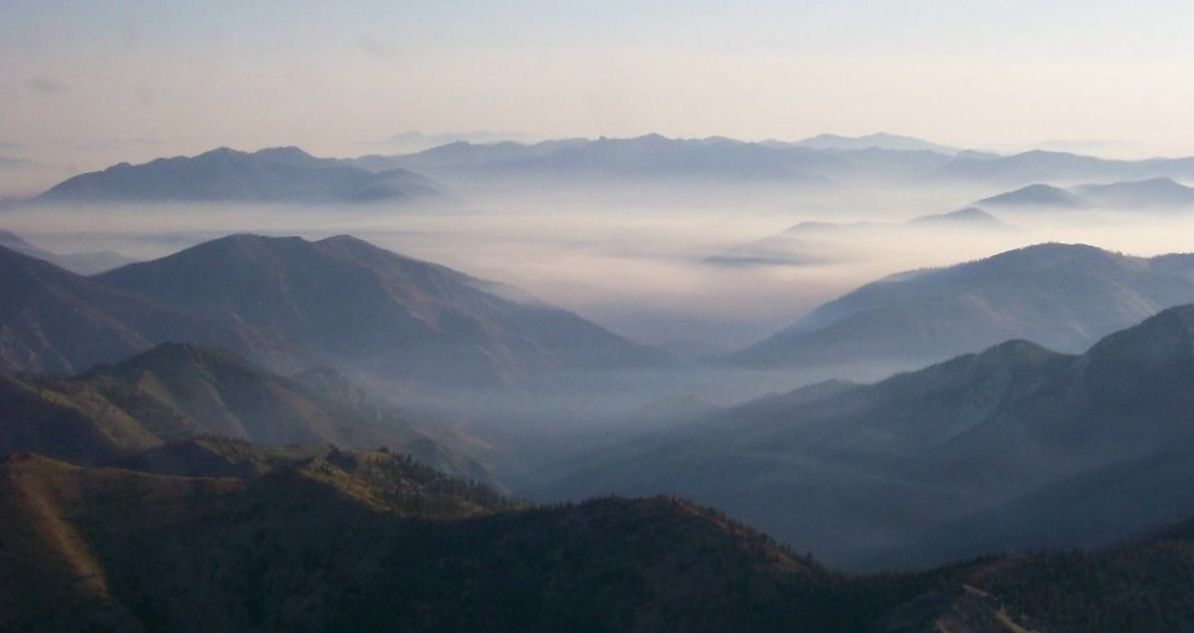
"Flying in smoke is extremely dangerous…it may not be what it seems until it's too late…looks can be deceiving. Flying in the smoke you can sometimes see up or down pretty well, you just can't see forward. And the density of the smoke can change in an instant, and with no warning."Barnstormer — Flying in smoke/smokey haze- safe or not?The ground view is the worst possible vantage point for evaluating smoke, because you tend to look up, and pick out reference points that you can see relatively near. But in the air, you're looking horizontally through miles of it, trying to navigate the necessary distance ahead at aircraft speeds. Before you go, check to see if PIREPs exist for your route: pilots who flew it in the last hour are your most reliable source of actual conditions. PIREPs are a more conventional thing, so they likely won't exist for backcountry destinations. You may have to monitor nearby CTAFs. When in doubt, don't go. Taking off in what is essentially IMC can be a lot easier than approach and landing.
 Flight through the Frank [Church] forward visibility, from the thread: Flying in smoke/smokey haze- safe or not?
Photo: whee
Flight through the Frank [Church] forward visibility, from the thread: Flying in smoke/smokey haze- safe or not?
Photo: whee
2 Visibility in Smoke Is Dynamic
"A pilot who believes that visibility in smoke will remain consistent is bound to be disappointed one of these days…One day I was headed north out of FAI to meet a helicopter which was helping move crews on the Flats…the visibility went from a mile and a half or so to nil, as the sun angle I was seeing changed. I did another 180 in the canyon, and considered my options. So, being very familiar with the mountain to my right…, I opted to initiate a climb, following the side of the mountain up to it's summit at about 6000 feet. I called for a pop up IFR clearance and continued the climb to 8000 feet, turned around and returned to FAI IFR. I broke out of the goo about ten north of FAI. "MTV — Flying in smoke/smokey haze- safe or not?Smoke doesn't just vary by location—it varies by which direction you're pointed and what time of day it is. Smoke layers are thinnest in the early morning before the air column warms and the layer rises. As it rises, moves, etc the density can be extremely inconsistent. If you're planning a backcountry trip in fire season, schedule your flying for the first half of the day. The conditions you launched in at 7:00 a.m. may have no relationship to what you're flying home in at 3:00 p.m.
3 METARs and TAFs Won't Tell You What You Need to Know
"If you plan to 'work it' with the smoke, I'd recommend being very experienced in the area you're working. Also check out all the TFRs in the area and be aware that there are a TON of...firefighting aircraft moving around between fires and airports. Kodiakmack — Idaho smoke?A five-mile ASOS report in smoke country is nearly useless. It doesn't tell you what the canyon looks like, which direction the visibility exists, or how fast things are changing. For smoke density by altitude, use the PM2.5 layer on Windy (Menu → Air Quality → PM2.5). Conventional surface readings can look clean while the layer you're flying through is a different story. For 48-hour dispersion forecasts, FireSmoke.ca shows animated smoke coverage similar to radar. And don't overlook the TFR picture—Watch Duty shows where firefighting aircraft are operating before you launch, which is the fastest way to understand where TFRs are developing. These should be depicted on ForeFlight and Garmin Pilot as well.
 Early morning smoke inversion that broke in a matter of minutes causing almost IFR conditions in an instant, from the thread: Flying in smoke/smokey haze- safe or not?
Photo: clippwagon
Early morning smoke inversion that broke in a matter of minutes causing almost IFR conditions in an instant, from the thread: Flying in smoke/smokey haze- safe or not?
Photo: clippwagon
Smoke Planning Tools
Quick reference to the tools mentioned in this article.
Watch Duty — Fire perimeters, containment, evacuation zones, air tanker tracking. Free.
Windy — PM2.5 Layer — Smoke density by altitude. Menu → Air Quality → PM2.5.
FireSmoke.ca — 48-hour smoke dispersion forecasts.
AlertWildfire.org — Live webcams at terrain across fire-prone areas in the West.
AirNow — Smoke Map — NOAA's animated smoke visualization tool. Useful for general area planning but note that the underlying readings can run an hour or more behind actual conditions.
4 Don't Plan Beyond 48 Hours
"Getting more than 48 hours on reliable smoke conditions is nigh onto impossible. Slight changes in the wind can make a big difference in smoke density in a given area. That means you can have good conditions for getting where you're going, but may get stuck later by poor visibility due to smoke. Even worse would be getting stuck with a fire coming your way if the wind shifts. If fires are burning in an area I'd like to go, I just don't go there."Flyhound — Wildfire Season Flight PlanningSmoke follows the winds aloft, not the surface reading. The strip might look clear at ground level while the layer you'll be flying through tells a completely different story. Use FireSmoke.ca to check 48-hour dispersion forecasts before you commit to a route. Build your plans around that window, and if you're flying into smoke country, add a buffer day to the trip. Don't put yourself in a position where you have to fly home on a schedule when conditions may not cooperate.
5 Decide Your Retreat Conditions Before You Leave
"Before entering the dark notch, I had already planned to turn back downstream if: the road did not sweep to the right, the smoke got too dense, and I concluded that I really did not know where we were. I would then follow the Boise River back downstream until the visibility improved, or we ended up in Boise."Trimtab — Trust Your InstrumentsIn the above quote the pilot identifies three specific conditions, decided before takeoff. Stick to that plan. Name your escape route beforehand—Trimtab had the Boise River. What's yours? When you're already in the canyon and the smoke is thickening is not the best time to be figuring that out. The pilot who sets hard stops and identifies an escape route on the ground turns around cleanly. The one who didn't is still negotiating with himself at a quarter mile. Indecision can kill.
From a recently overheard conversation: the pilots most likely to survive aren't necessarily the most talented—they're the most disciplined.
 Visual conditions from forest fire smoke can be a deceptive form of IMC with initial acceptable visibility, then degrading quickly and unpredictably, from the article: Hazards of Wildfire Smoke
Photo: Brad Thornberg
Visual conditions from forest fire smoke can be a deceptive form of IMC with initial acceptable visibility, then degrading quickly and unpredictably, from the article: Hazards of Wildfire Smoke
Photo: Brad Thornberg
6 Slow Down to Keep Your Options Open
"I slowed down to my canyon approach speed of seventy and pulled on twenty degrees of flaps…I slowed to sixty, then fifty, trimming for hands off level flight. If needed, I could safely slow it down to forty indicated and still make a safe and tighter canyon turn."Trimtab — Trust Your InstrumentsSlower speed buys you two things: more time to decide, and a tighter turn radius if you need to about-face. Committing to a smoke-filled canyon at cruise speed is committing with no margin. Approach it like a short-field landing—configured, stabilized, and at an airspeed that still gives you options if the answer turns out to be no.
7 Know Your Reference Points
"Was flying through Oregon enroute California in my Pitts, no compass, before gps, in smoke, at 10k, following I-5. Near Medford I was losing ground reference and dropped down to regain it. Ended up between the freeway lanes at 200' with about 1/2 mile viz. Called Medford tower to let them know I was going to be low-level through their zone. They said ‘were you going?’, I said ‘I'm following I-5, I'm out of gas, going to Ashland", to which they replied ‘Ashland is 1/8 obscured in smoke, tell us a landmark you see along I-5.'"Karmutzen — Wildfire Season Flight PlanningPick your linear reference on the sectional before you launch—a river that drains to a valley floor, a road that leads somewhere useful, a ridgeline you can follow out. Know which direction it flows and what's at the bottom before the smoke takes everything else away. If you're in controlled airspace or just an area with radar coverage and conditions start changing, call ATC as soon as you notice—not when you're already in trouble. The earlier the call, the more options they have to help.
These are essentially "stupid VFR-into-IMC tricks" for staying alive. We're talking about trying to negotiate terrain visually in variable obscuration—something our instructors and elders always warned us to not do, in the same conversation as scud-running. For the instrument-rated pilots in properly-equipped aircraft, it may be a decision to use that skill and pop-up IFR.
8 Load Your GPS Before You Go
"With Soldotna being only 10 miles away and me very familiar with getting there, I opted not to bring my iPad…but since I've been cautiously flying in the smokey haze for a month now I did set up a route in ForeFlight on my iPhone—just in case...I did end up using my iPhone/ForeFlight to keep me on direction because none of the landmarks I use were visible."Barnstormer — Flying in smoke/smokey haze- safe or not?Knowing a route by heart is not the same as being able to fly it in smoke. GPS in this environment isn't about finding your destination—it's about holding a heading when there's nothing outside to reference. The "just in case" device SmokeyTheBear almost left behind is the one that kept him on course. Have it loaded and a route set before you go, not after you realize you need it. And even with a reliable navigation device, be practiced up on maneuvering by reference to instruments only, just in case.
 Windy Air Quality screen from thread: Idaho smoke?
Photo: Pierre_R
Windy Air Quality screen from thread: Idaho smoke?
Photo: Pierre_R
9 Stay Flexible
"The smoke started to fill in on Wednesday...There was no reason to stay and could have even left a day early."Dog is my Copilot — Idaho smoke?This is the one that's hardest to act on when everything looks good on the surface right now. Wildfire and smoke isn't just a visibility problem—a wind shift can set the actual flames moving toward your location while you're on the ground waiting it out, expecting the problem to sort itself out. Will it get better? Or worse? Watch Duty lets you monitor fire perimeters and containment, which can help make a go/no-go decision. AlertWildfire.org has live webcams across fire-prone terrain in the West so you can see actual ground conditions before you launch, or make a decision to bail early from the backcountry. Use them to pick your window, not to justify a decision you've already made. Stay flexible and react appropriately to changing conditions, not an arbitrary sechedule.