Airport Location:
FAA Identifier: 33U Dutch John, Utah
Latitude/Longitude: 40-55-04.1250N / 109-23-26.3785W
40.9178 / -109.3906
Elevation: 6561 feet MSL (Estimated)
Magnetic Variation: 14E (1985)
Land Area Covered: 296 acres
From City: 1 nautical miles SW of Dutch John, UT
County/Parish: Daggett, UT
Runway Information:
Runway: 07/25
Dimensions: 4450 x 100 ft.
Surface: Grass, sod-Natural soil - in good condition
Runway: 11/29
Dimensions: 6000 x 60 ft.
Surface: Asphalt - in good condition
Fuel: No
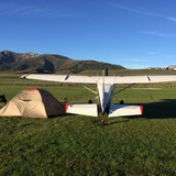
Lodging: Red Canyon Lodge (5.7mi away with shuttle service), campgrounds close as well.
Manager:
Mr. Brian Raymond
95 North 1st West, P O Box 219
Manila, UT 84046-0219
435-784-3218
Remarks:
DEER AND ELK ON AND INVOF ARPT.
TWO CROSSING DIRT/TURF RYS APPEAR TO BE OPEN BUT ARE CLOSED & NOT MAINTAINED.
ACFT IN EXCESS OF 10,500 POUNDS MAXIMUM GROSS WEIGHT PROHIBITED FROM USING APRT.
EXT 134
LIMITED SNOW PLOWING DURING WINTER MONTHS
RY 07/25 NOT MAINT; NUMEROUS RODENT HOLES; NUMEROUS TREES ON APCH ENDS.
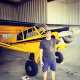
Hello everyone! I have tried to include as much pertinent information about 33U as I could find. I will be flying into this airport in a few weeks for the first time. I am trying to do as much due diligence as possible before I head out there. I am hoping to hear from some of you that have flown in and out of there before. I am aware of the field elevation and have thought about density altitude. My plan is to arrive in the morning sometime and camp overnight. Not sure when I will be leaving the next day. That really all depends on weather and density altitude. I would appreciate any helpful tips, thoughts, etc. Thanks in advance!
33U Dutch John, Utah
Thu May 31, 2018 11:19 am
- hawaiisurfer offline
- Posts: 26
- Joined: Sun May 10, 2015 2:11 pm
- Location: Provo
Thu May 31, 2018 12:16 pm
Re: 33U Dutch John, Utah
I’m curious why you’re camping here instead of one of the other dozens and dozens of other great Utah backcountry airstrips better suited for camping? Unless you have some other reason to be there.

Thu May 31, 2018 12:43 pm
Re: 33U Dutch John, Utah
It's been more than a few years since I landed there so I don't have any current information, but do a low pass first. We've had to scare the antelope off the runway more than once.
- amacbean offline

- Posts: 544
- Joined: Mon Aug 08, 2005 3:22 pm
- Location: Springville
- FindMeSpot URL: http://share.findmespot.com/shared/face ... 7GsCKYBvNX
- Aircraft: Cessna 170b
Thu May 31, 2018 1:45 pm
Re: 33U Dutch John, Utah
25 years a go I went to the 180/185 get together and remember it big and wide open. Camped by the taxi way and there were showers in the one hangar. Did a raft trip below the dam that was pretty fun.


Thu May 31, 2018 4:26 pm
Re: 33U Dutch John, Utah
Dutch John doesn't lend itself to camping under the wing. Camping and cabin rental is down the road. Big long asphalt paved runway. Be aware of the downdraft over the river on a 29 final. Not a challenging airport by any means.
Unless your meeting a river guide to take you fishing on the Green for a day I'd suggest heading elsewhere. You might have an entirely different perspective after you go, so find out for yourself. Get on Google Earth and take a look.
My .02 worth.
Rich
Unless your meeting a river guide to take you fishing on the Green for a day I'd suggest heading elsewhere. You might have an entirely different perspective after you go, so find out for yourself. Get on Google Earth and take a look.
My .02 worth.
Rich
- PittsDriver offline
- Posts: 213
- Joined: Fri Jan 08, 2016 11:10 am
- Location: Sandy, Utah
- Aircraft: '55 Cessna 180 and '91Pitts S-2B
Thu May 31, 2018 9:45 pm
Re: 33U Dutch John, Utah
Thanks for the responses. And I agree with you all. I wouldn’t normally pick to camp there, but I’m meeting up with my young men’s group and some other leaders who will be camping next to the airport.
I did fly out to Garden Valley, ID last weekend. It was amazing. The strip is in great condition.
I did fly out to Garden Valley, ID last weekend. It was amazing. The strip is in great condition.
- hawaiisurfer offline
- Posts: 26
- Joined: Sun May 10, 2015 2:11 pm
- Location: Provo
Wed Jun 06, 2018 11:47 am
Re: 33U Dutch John, Utah
Man that's a place I haven't been to in a long time. We flew a 182RG along with another plane into there when I was a lot younger and fished the Green for a few days. The fishing was epic, if you are into that you should book a guide w/ boat and haul some monsters out of there. We stayed in the lodge and played "hide the smuggled beer" from the cops since it was a dry county. I will never forget that courtesy car we used, some old POS chevy station wagon. Burned more oil than gas, and with 6 people in it the back end drug on the ground continuously.
I remember it being wide and open, not much else at the airport worth noting. If it's like I remember it then I'd agree that camping there is less ideal, but if you're in a group nearby it could be fun. I seem to recall a slope to the runway as well, but could be imagining that. The older I get the less I remember things that happened ~25 years ago.
I remember it being wide and open, not much else at the airport worth noting. If it's like I remember it then I'd agree that camping there is less ideal, but if you're in a group nearby it could be fun. I seem to recall a slope to the runway as well, but could be imagining that. The older I get the less I remember things that happened ~25 years ago.
Fri Jun 08, 2018 5:14 pm
Re: 33U Dutch John, Utah
colopilot wrote:Man that's a place I haven't been to in a long time. We flew a 182RG along with another plane into there when I was a lot younger and fished the Green for a few days. The fishing was epic, if you are into that you should book a guide w/ boat and haul some monsters out of there. We stayed in the lodge and played "hide the smuggled beer" from the cops since it was a dry county. I will never forget that courtesy car we used, some old POS chevy station wagon. Burned more oil than gas, and with 6 people in it the back end drug on the ground continuously.
I remember it being wide and open, not much else at the airport worth noting. If it's like I remember it then I'd agree that camping there is less ideal, but if you're in a group nearby it could be fun. I seem to recall a slope to the runway as well, but could be imagining that. The older I get the less I remember things that happened ~25 years ago.
Thanks for the input. I love fly fishing, but not this trip.
Someone told me that there can be some good downdrafts as the airport and to land beyond to 1000-footers. As long as the weather looks good it should be a fun trip.
- hawaiisurfer offline
- Posts: 26
- Joined: Sun May 10, 2015 2:11 pm
- Location: Provo
Sun Jun 17, 2018 8:15 pm
Re: 33U Dutch John, Utah
Well, I flew out to 33U Friday. The ride out there kicked my butt. I tried to leave early in the morning, but couldn’t get the plane scheduled. So, I took off at 12:30. That was by far the bumpiest ride I’ve had to date. The winds were howling, gusting 40 knots, which made landing interesting. It was 30 degrees off my right nose. I took one pass over the field to check the wind sock, then a second at a lower altitude down the runway to test the wind and my confort level. Finally, I went for it. I only used 2 notches of flaps and carried an extra 10 knots of speed, which was the trick. I thouched down and felt stable so I parked and quickly got the plane tied down. That was my most challenging landing to date. I wouldn’t have tried it if I hadn’t felt confident. I also haden’t experienced density altitude that high. It was at 10,200 ft. In all it was a great confidence builder.
You guys are right. It’s not the camping destination that I would pick, but I had fun with th guys I met up with.
Smiley Creek is next on my list this summer. Hopefully, I will get there in a couple weeks.
Thanks again for all your tips and help!
You guys are right. It’s not the camping destination that I would pick, but I had fun with th guys I met up with.
Smiley Creek is next on my list this summer. Hopefully, I will get there in a couple weeks.
Thanks again for all your tips and help!
- hawaiisurfer offline
- Posts: 26
- Joined: Sun May 10, 2015 2:11 pm
- Location: Provo
Sun Jun 17, 2018 9:16 pm
Re: 33U Dutch John, Utah
Your going to love Smiley Creek. Worlds of difference from Dutch John.
Rich
Rich
- PittsDriver offline
- Posts: 213
- Joined: Fri Jan 08, 2016 11:10 am
- Location: Sandy, Utah
- Aircraft: '55 Cessna 180 and '91Pitts S-2B
Sat Jun 23, 2018 8:42 pm
Re: 33U Dutch John, Utah
Thanks, Rich! Looking forward to it!
- hawaiisurfer offline
- Posts: 26
- Joined: Sun May 10, 2015 2:11 pm
- Location: Provo
DISPLAY OPTIONS
Who is online
Users browsing this forum: No registered users and 0 guests
Latest Features
-
Live to Tell
A Minnesota pilot is surprised to learn that the sudden asymmetric drag of an out-of-rig ski can…Read More -
Creators
Working in some of the Yukon's most beautiful and remote environments, photographer Simon Blakesley captures aircraft in…Read More -
Aircraft Ownership and Maintenance
Upgrading to big tires can make a huge difference in backcountry performance, but with those gains come…Read More -
Tales from Yesteryear
In this tale from bush flying yesteryear, Don Cogger signs up to help Atlee Dodge Jr recovery…Read More


Latest Knowledge Base
-
Destinations
A regional guide with ideas for winter camping destinations in California, Nevada, New Mexico, and Arizona.Read More -
Aircraft
Finding an affordable aircraft that can handle the backcountry for $80K or less? A challenge for sure, but with the…Read More -
Aircraft
01.29.2018 - Zane - Updated tire diameter graphic to add 8.50x10 Guide to tires for use in the backcountry and off-airport landing…Read More -
Pilots
12.22.2013 - Initial article format Operating aircraft on skis and negotiating a snow-covered landscape is an entirely unique skillset and environment.…Read More


