Backcountry Pilot • Aniakchak Caldera and Pumice Creek

Aniakchak Caldera and Pumice Creek

Did you fly somewhere cool, take photos, and feel like telling the tale to make us drool from the confines of our offices? Post them up!
25 postsPage 1 of 21, 2

Aniakchak Caldera and Pumice Creek

I work for the National Park Service in my day job, and have been to Aniakchak every year for 14 years...until this year. It looked like I was going to be out of luck, as the season was pretty much over for fieldwork. So I started looking for weather and time to get myself down there in the milkstool...

Today was looking pretty good based on forecasts throughout the week, and the forecast seemed to hold as the day approached. Finally, last night I got myself organized, and had my son out helping me get ready for one of today's other commitments. The first of those is the delivery of a freight container. We have finally become full-blooded Alaskans, we bought a freight container to use for storage so we can clean up our garage and get the mess in the yard under control. Of course the guy wanted to deliver it on Aniakchak day.

"What time?"

"Oh, say about 1 pm."

Muttering to myself..."1 pm...that gives me like 4 hours from sunup...I can make that work...be a bit rushed if we don't get out promptly though..."

To him..."Okay."

So last night my son and a pal of his were helping me get the supports leveled for the container. We had previously done it, but were checking after a few days and adding a little height to the supports to make sure we had good door clearance on the uphill side. Of course we were doing that in the dark because I was working until after dark yesterday...but we got it done. Then Cedric's pal left to go home. Usually, he has arranged some sleepover or other, but here it was, a weekend where my son had not gotten himself any plans!

"You want to fly to Aniakchak with me?"

"Sure, well, I guess, I mean I don't have anything else lined up, so yeah, I could do that..."

The immortal words of a 12-year-old explaining how thrilled they are to spend a morning with their dad. Oh well, whatever works.

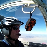
This morning I got him up and off we went. Stopped for gas and snacks, he got to buy snacks while I got the gas, then off to the plane. Preflight, fueled up, got the all-important snacks in place, Cedric untied the plane, then put on his winter gear. He was cold, wanted to wear enough clothes to warm up. Finally, we bundled in and were taking off just a few minutes after sunup. The sun was low over the mountains with Big Creek in the foreground as we headed south.
Image

Cedric started looking sleepy within five minutes of departure, so I asked him if he wanted to fly. He did, so for the next 20 minutes he kept us headed in a pretty straight course southward toward Aniakchak while I looked around and acted like I wasn't helping him. Love those rudder pedals.

Finally, he asked me to take the yoke again, and leaned his head on my shoulder and zonked. I was pretty sure he'd be asleep for most of the trip down, that is just the reality of his rhythm. But if we landed, that would wake him up, and I have a spot I've been wanting to land in the caldera, so we were headed there. As he slept, we passed Pilot Point out his window.
Image

At that point, I started climbing. The caldera has two passes that go into it, one about 1,000 feet, the other about 2,000, but unless I wanted to fly around to enter one of those, I would need at least 3,000 feet to peek in. Although we were in clear sky, there were clouds shrouding part of the top of the caldera, so I didn't know exactly what we'd find when we got there. The mountain makes a pretty good helping of weird weather all its own. Sometimes it will be cloudy everywhere else but the caldera will be blue sky. Sometimes it will be blue sky everywhere and the caldera is like a snow cone spilling clouds over. What would we get today?

As we got near, I could see that we were going to have at least part of the caldera open, and it looked like under the clouds the Gates might be open as well. So we could fly in, descend and land, then take off and fly out the Gates. I was hoping to fly down the river, then back up to King Salmon by Mount Chiginigak. But around 20 miles out I was starting to doubt whether it was going to work quite like that. Starting around 30 miles out we were getting a little bit of burbly air. Finally, as we approached, it got just burbly enough that it was unsettling. But we were definitely going to be seeing in.

I woke up sleeping beauty and started telling him what we were seeing, starting with the cinder plains outside the caldera. Then we broke over the rim and saw Surprise Lake greeting us.
Image

The upper end of Surprise Lake has some cinder cones around it, and Vent Mountain rises up right in the middle of the caldera floor, and is taller than the wall we flew in over, though not taller than the wall on the other side...
Image

Image

The east side of the caldera was pretty unappetizing air as we flew around to check things out. Looking down at the lake surface, I could tell that the wind was light on the caldera floor, but if we descended we were going to need to either climb back up corkscrewing to gain altitude, or fly out the Gates. The wind in the Gates is never calm, and flying over near the Gates told me I wasn't going to do that today. So we elected to save the landing for another day. Instead, we caught a massive updraft behind Vent Mountain and took another turn around the place. I snapped a photo of the western section, where the eruption pit from 1931 is in the distance, and half cone, an eruption from around 500 years ago, is visible closer in.
Image

Since we had brought cokes, and since Cedric always does better if we stop and stretch, and we wanted to empty our bladders to make room for the coke, we agreed we'd find someplace to land on the way home. In the caldera, I've walked most of the floor, so I know exactly where I can operate. But outside the caldera, there are the established airstrips, and there are lots of cinder blows that have airplane activity on them.

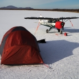
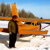
A friend of mine that is familiar with the Pumice Creek cinder blow had told me that it was sufficiently firm for my little non-bush wheels, and it was the first option we were going to come to. So I flew over to it, found a stiff wind coming down off the mountains, flew a couple practice approaches, and then landed. The strip we used, of the options on the blow, was about 1000'. Landing in 1000' in a PA-22 is no big deal. Taking off in that span is no big deal now that the engine has been overhauled and the prop is new, but I wouldn't have done it two years ago. The cabin in the background is used by the Alaska State Troopers.
Image

From there, it was a launch home and look for critters all the way. On the way out of King Salmon I had spotted a moose while Cedric was snoozing. So we were looking for a moose all the way back. But no luck on that. What we did see a few miles before we got to the Egegik River was a beautiful bull caribou.

A totally lovely flight. Had a great morning. Got back in time...but the guy canceled on us. So we could have played around a little more. Oh well. There will hopefully be more opportunities.
Troy Hamon offline
User avatar
Posts: 913
Joined: Tue Apr 06, 2010 8:27 am
Location: King Salmon
FindMeSpot URL: http://share.findmespot.com/shared/face ... 04iX0FXjV2
Aircraft: Piper PA-22

Re: Aniakchak Caldera and Pumice Creek

Troy
Great pix
Is that right behind Port Heidan?
If that is the same place I made it to the top and took some pictures about 6 years ago, looks like the same place??
Great, that 12 yr old is getting to see some of these things now, he won't know it's special for a few years though!!
GT
M6RV6 offline
User avatar
Posts: 2313
Joined: Mon Feb 25, 2008 5:52 pm
Location: Rice Wa. 82WN Magee Creek AERODROME
FindMeSpot URL: http://share.findmespot.com/shared/face ... sWKXuhKlg2
Have as much Fun as is Safe, and Keep SMILIN! GT,

Re: Aniakchak Caldera and Pumice Creek

Troy- Your photo's and stories are the best. Just love seeing that tri-pacer at work =D> =D>
DBI offline
User avatar
Posts: 394
Joined: Tue Nov 29, 2011 5:17 pm
Location: Stevensville, Montana

Re: Aniakchak Caldera and Pumice Creek

I do miss that area had to fly by all the time enroute to Cold Bay for the next round of Marine Mammal surveys. Ballsy to go in a Tri-Pacer, but if the conditions are right, why not. I took this one from the Otter after winds scoured the snow off the flats leaving it incised in the erosional features:
Image

The Pavlov twins, a bit further down the peninsula. If you see the craggy bits to the right and beyond the twins, there is a DC-8 imbedded in them. His last words on approach to Cold Bay was, "hey, how high are the mountains around here?" Alaska is a paradise of volcanic features.
Image
dogpilot offline
Took ball and went home
Posts: 902
Joined: Sun Feb 19, 2012 10:20 pm
Aircraft: Cessna 206H Amphib, Caravan 675 Amphib

Re: Aniakchak Caldera and Pumice Creek

Thanks guys.

M6RV6, yes it is the caldera behind Port Heiden. Pretty amazing place. When you are camping down in there you really feel as though you are in the bowels of the earth. And that's because you are.

DBI, thank you. I enjoy writing, especially turning real experience into words and photos. As a scientist, I usually am sick of my own work by the time it is written up, but I don't seem to get tired of flight stories, even my own.

Dogpilot, if you pick your days, the Tri-Pacer is a fabulous traveler. Especially when it's all you've got...
Troy Hamon offline
User avatar
Posts: 913
Joined: Tue Apr 06, 2010 8:27 am
Location: King Salmon
FindMeSpot URL: http://share.findmespot.com/shared/face ... 04iX0FXjV2
Aircraft: Piper PA-22

Re: Aniakchak Caldera and Pumice Creek

dogpilot, wanted to add, loved the photos. I've never been down to see the Pavlovs, may have to add that mission to the future possibles list...
Troy Hamon offline
User avatar
Posts: 913
Joined: Tue Apr 06, 2010 8:27 am
Location: King Salmon
FindMeSpot URL: http://share.findmespot.com/shared/face ... 04iX0FXjV2
Aircraft: Piper PA-22

Re: Aniakchak Caldera and Pumice Creek

Troy,

If you get that far, mosey on down past CDB and False Pass, and take a turn around Unimak Island. That place is like Never-Never Land....no place comes even close.

MTV
mtv offline
Knowledge Base Author
User avatar
Posts: 10514
Joined: Sat Feb 25, 2006 1:47 am
Location: Bozeman

Re: Aniakchak Caldera and Pumice Creek

I just ran that through the skyvector advance planning process. Looks great. Looks like it would be best done with an overnight or two somewhere, so I would need at least two, if not three, days of good weather. And they would have to coincide with time I could be away. Which is all do-able. Just means I need to look for opportunities to make it happen. What a great voyage. I have a bunch of others in mind too...
Troy Hamon offline
User avatar
Posts: 913
Joined: Tue Apr 06, 2010 8:27 am
Location: King Salmon
FindMeSpot URL: http://share.findmespot.com/shared/face ... 04iX0FXjV2
Aircraft: Piper PA-22

Re: Aniakchak Caldera and Pumice Creek

Troy,

All I can say is WOW, spent time in that area, but before I had wings. WOW COOL, my boy would love that! I am just abit jealous! lol
soaringhiggy offline
User avatar
Posts: 711
Joined: Tue Dec 13, 2005 8:22 pm
Location: Kimberly, ID
48 Stinson 108-3

Re: Aniakchak Caldera and Pumice Creek

Gotta love an adventure story with pics. Thanks for the post.
ozy offline
Posts: 129
Joined: Sun Jun 10, 2012 10:38 pm
Location: Australia

Re: Aniakchak Caldera and Pumice Creek

Unimak Island is a really cool place. We had to go to check out the Strato Volcano there, I forget the name, for atmospheric sampling. Winds where up over 100 its at 15,000. It was a try to maintain attitude day from the turbulence.

Landing at False Pass is a trick, you have to not be fooled into thinking the bridge (it is dirt, on wood, no rails and is just a continuation of the runway) is part of the runway. Fine if your a Cub, but in the Twin Otter, it would collapse. Don't get too dismayed, we actually paid the inhabitants to collect seal and sea otter scat (poop). We would stop in and collect the fruitful bounty, pay them and move on. Fun stuff to manifest.

Further down, Ft. Glenn is kind of spooky as well, very 28 days later.
Image
dogpilot offline
Took ball and went home
Posts: 902
Joined: Sun Feb 19, 2012 10:20 pm
Aircraft: Cessna 206H Amphib, Caravan 675 Amphib

Re: Aniakchak Caldera and Pumice Creek

I was flying around Westdahl Volcano during its first eruption....1977?? Windy, but okay that day, flying around in a Super Cub, watching chunks of rock the size of the Cub being ejected into the sky, glowing white hot, then cooling to red, then black as they fell back into the cone. Unfortunately, no camera..... I still remember watching the lava flowing under the ice cap, through the pot holes melted through the ice and snow. That one blew ash well into the flight levels, verified by Reeve Aleutian, that same day.

The big and very active volcano on Unimak is Shishaldin....a near perfect cone, and nearly always steaming.

On the south side, there are old volcanic vents and tubes that have been exposed by erosion. Saw a big bull caribou swimming around in one of those up at the head of a canyon one day, and halfway down the tube, there was a hole, with a jet of water shooting out of it, forming the stream I was flying up. North side has rivers that disappear into the tundra, only to reappear downstream a mile or so. Wild place, in a lot of ways.

I spent a ten days there once, on a stakeout....boy was that fun. That's when I learned to NEVER accept someone else's idea of what constitutes "camping gear".

MTV
mtv offline
Knowledge Base Author
User avatar
Posts: 10514
Joined: Sat Feb 25, 2006 1:47 am
Location: Bozeman

Re: Aniakchak Caldera and Pumice Creek

Flew out of Chignik counting salmon from a Super Cub. Those cinder blows sure were handy... for a pit stop
I remember learning to fly the Super. The manual said, "If you have been flying a Luscombe or Tri Pacer... just use half throttle for the first few flights. That seemed to be good advice. Sure liked the Borer prop.
BUT... the wobble pump to get the gas from the belly tank to the wing was sure tiring on the hand and arm..!

Nice photo and narrative of your flight with your son.... well done. I took my sister low level to Glacier Bay one sunny afternoon. She fell asleep. Last time I ever took that lazy hippy flying. What a waste of a good airplane seat and outstanding scenery...

Thanks for posting.
flightlogic offline
User avatar
Posts: 616
Joined: Wed Dec 24, 2008 2:51 pm
Location: Prescott
Flying is dangerous. If you think otherwise, you are new at this sport. Mind the gravity not the gap.

Re: Aniakchak Caldera and Pumice Creek

Been too busy working and flying to post, a good sort of problem to have. I was hoping to get in an overnight camping trip in the Caldera with my son, but that hasn't worked yet. Maybe sometime in the next few weeks we'll have that miraculous weather to make it work. Meanwhile, we had some pretty decent weather and my FIL wanted to go for a flight...and he'd never seen Aniakchak. I put up a real fuss, but he eventually talked me into taking him for a ride. Okay, maybe it was my idea. But I haven't been to Aniakchak this year yet either, and needed to get my fix. And again, I was hoping to get in a landing while we were there.

The weather in King Salmon was a bit testy, with occasional low level wind shear and occasional moderate turbulence below 6000, and after we took off in mid-afternoon it was certainly a bit burbly. The wind was supposed to be diminishing so I figured we'd climb up to get smoother air on the way down, since we'd need to climb anyway to get into the caldera, then we could get down and do some critter-spotting on the way back up the peninsula. Somewhere around 1200 feet it smoothed out, and continued to be great all the way up to 3500 feet. On the way down, we had a great view of Peulik and Chiginigak, and I could see Aniakchak on the horizon from nearly 100 miles away. There were just a few clouds hanging around it, with a mostly clear sky greeting us as we sailed south. King Salmon River, Egegik River, Fort Jensen airstrip, Blue Mountain Lodge, Ugashik and Pilot Point, Mother Goose Lake, Pumice Creek Lodge, Cinder River Lodge...there are certainly some signs of people scattered along as you go down the peninsula. And yet, it is still like a long trek into the wild, further and further from the known world, a remarkable journey which, for us, culminated in us popping over the caldera wall at 3500 feet with a view of Black Nose on our left, and the Gates below us and also to the left.
Image

The Gates is mighty impressive no matter how you look at it, but it is probably most impressive when you are at the bottom of it looking up. I was happy to have a chance to look at it from above on this day.
Image

I managed to completely miss getting a photo of the lake this time, but I did get a really nice photo of Half Cone. This is the site of an eruption around 500 years ago that was pretty substantial, it appears to have been one of the more noteworthy eruptions since the original caldera-forming event 3500 years ago, which was beyond huge.
Image

While I wanted to land, and the weather was not too terribly bad, it was plenty bumpy over the caldera, and I try to be pretty cautious. The wind was whipping from the west down on the caldera floor, as evidenced by the waves on the lake. The section of floor where I would land is more on the western side of the caldera. So I would be landing into rising terrain with a nice headwind, an optimum situation for landing. But landing is not the hard part with a Tri-Pacer. For takeoff, I would be facing rising terrain with a headwind that was composed of a very strong downdraft. Didn't take me long to veto that...not today senator...so we flew a lap, got bounced around, and turned to fly down the river a bit. Last time the weather was unfriendly over the river, so it was nice to be able to get a look at the terrain downstream, starting with flying out over the Gates.
Image

After looking at the residual effects on the landscape of a flood that drained the caldera when the Gates failed around 2,000 years ago, I was inclined to head over toward Chiginagak to get a nice view of the volcano. But then I looked down at my GPS. We were making 70 mph ground speed, and our estimated time to get back to King Salmon was more than our fuel endurance...

So we abandoned the mountains by setting a course direct for Ugashik. Though that meant we actually had some terrain to fly over first, and lovely terrain it was.
Image

This was one of my favorite sights on the trip, a ridge that was in the upper Cinder River watershed.
Image

Image

We flew over Painter Creek Lodge, then past Mother Goose Lake, and descended for landing at scenic Ugashik.
Image

I've flown over Ugashik a lot of times. But I had never landed there. We didn't strictly need to land, as we were getting better ground speed, but the coffee needed to be set free, and I had a five gallon jug of gas that would be better in the tanks, and it seemed like a good excuse to see another runway. So we called in from 10 out, then made a call from 5, downwind, and final, landed nicely and taxied down runway 24 to pull off at the little maintenance building. We had barely got the engine off when an ATV and an SUV pulled up. The two gentlemen that arrived first were brothers and we chatted for a while as they told us all the salient news that could be transferred. After twenty or thirty minutes, one of them took off and another gentleman arrived. One of the things we learned was that 6 people live in the village of Ugashik. So half the town came out to visit us, just because we were there. Actually, when they first pulled up, the guy asked if we were lost or confused...
Image

After an hour of shooting the breeze, we loaded back up, sans coffee, and headed back north. This time we tried to keep it down where we might be able to spot some animals, but all the way past the Becharof Outlet, we saw only swans. But we got a good look at Blue Mountain Lodge and the Fort Jensen strip, which looks like a major piece of runway. Then we headed a bit east toward Headwater Creek, thinking we might see a bear. On the way there, we came across a magnificent bull caribou, all alone, then a little later in the creek a cow moose. But no bears. Then we moseyed over to Big Creek and flew down the creek to King Salmon and called it a night.

Cedric and I may make that camping trip yet...
Troy Hamon offline
User avatar
Posts: 913
Joined: Tue Apr 06, 2010 8:27 am
Location: King Salmon
FindMeSpot URL: http://share.findmespot.com/shared/face ... 04iX0FXjV2
Aircraft: Piper PA-22

Re: Aniakchak Caldera and Pumice Creek

Troy,
Thanks for reminding me that I screwed up by not heading to your area when I had the chance in 2011.
Good fishing, Eddie's Fireside Burgers, and great scenery.
Keep the photo's and commentary coming..... and get Cedric out camping!

Mark
SkyTruck offline
User avatar
Posts: 491
Joined: Sun Aug 27, 2006 4:48 pm
Location: KVCB, KBZN, NIN(AK)
'80 A185F

Re: Aniakchak Caldera and Pumice Creek

Spent many stormy days and windy nights in that cabin at Pumice Creek, during my Game Warden days. First time there asked why the cabin was cabled down with 1" cable. He said just wait and u will see why :shock: that night it blew 90mph all night. Cubs were tied to a cable and were flying about a foot off the ground when a gust would hit. #-o
DonC offline
Contributing author
User avatar
Posts: 816
Joined: Sat Oct 25, 2008 6:52 pm
Location: Twin Falls, Idaho
Keep the shiney side up and the dirty side down...

Re: Aniakchak Caldera and Pumice Creek

Sunday afternoon I took another trip to my favorite place. The wind was so calm that Becharof Lake was like a mirror. The ride was quite bumpy despite the calm winds...afternoon thermal heating was bumping us around, but it was not bad and I was looking forward to the opportunity to see the caldera from my plane without getting tossed all over the place.

Image

I thought about touching wheels on Jensen Strip just because...but kept on heading south in order to make my way down there and save the landings for the areas around Aniakchak.

Image

Chiginigak Volcano was visible from the moment we lifted off in King Salmon, but it was looming large behind Mother Goose Lake as we crossed over it on our way southbound.

Image

Over top of Mother Goose Lake, I looked down and practically gasped. Wow. I grabbed my camera to get the color of the water...looked tropical. I bet it wouldn't feel tropical though.

Image

Last fall I met the owner of Painter Creek Lodge. I told him I had thought about landing a few times, but didn't want to disturb their guests. He laughed..."Well, we haven't had any guests for three years, we've been closed! How would you like to buy a lodge?"

I wasn't really interested in buying a lodge, but he invited me to drop in anytime. So when we got near, I tried to identify the wind direction, noticed that the runway was uphill toward the west and that it was nearly a direct crosswind, so we set up and landed uphill. I flew a couple laps getting set up, and there was no sign of life, so the winter watchman must have already left, and it didn't look like anybody was there, so we just stayed on the runway and stretched our legs.

Image

We took off east and flew over next to a slope with an upslope wind in order to catch the free lift, and rode it all the way up to crossing altitude to get over to the Pacific side.

Image

Then we headed to the coast and Amber Bay.

Image
Troy Hamon offline
User avatar
Posts: 913
Joined: Tue Apr 06, 2010 8:27 am
Location: King Salmon
FindMeSpot URL: http://share.findmespot.com/shared/face ... 04iX0FXjV2
Aircraft: Piper PA-22

Re: Aniakchak Caldera and Pumice Creek

At Aniakchak Bay, we passed a cabin where I've spent a lot of nights, right next to the mouth of the river, then turned upriver to fly the river all the way up to the caldera.

Image

After flying upriver, the caldera came into view, along with The Gates, the gash in the caldera wall that the river flows out through.

Image

Image

Passing into the inside of the caldera over The Gates, I turned left and flew around next to the caldera wall, getting a great view of the huge obsidian cliffs of Black Nose.

Image

It was eerily smooth, not the normal experience. I flew around, climbing as I went, and got up above the western rim in order to get a good view back into the caldera.

Image

Image

Image
Troy Hamon offline
User avatar
Posts: 913
Joined: Tue Apr 06, 2010 8:27 am
Location: King Salmon
FindMeSpot URL: http://share.findmespot.com/shared/face ... 04iX0FXjV2
Aircraft: Piper PA-22

Re: Aniakchak Caldera and Pumice Creek

There are a couple places in the caldera I'd like to land. In fact, I intend to land there. When the conditions are right.

And we certainly had the right wind conditions to land, so in that sense, the conditions were right. But it is springtime. I'm afraid of springtime. You can walk along in the spring and find places next to maintained gravel strips where your boot will sink 6 inches into the mud. A few days before this flight, I had landed and shut down in the middle of Kulik strip in order to get out and walk around at 750' and see how the ground was. It was hard and dry, which is no surprise given the hot dry spring we've been having.

But the caldera is 1100' on the caldera floor, and surrounded by higher slopes that hold snow longer. So I had already decided that I was going to be skipping the caldera landing regardless of whether there appeared to be good conditions. I'm just scared enough to want to be sure. And as we flew over, there were dark wet spots in the landing zones, and snow a couple hundred feet upslope. No thanks.

Image

So we flew a couple more laps and soaked in the awesomeness before heading out over The Gates and westward toward the Bristol Bay coastline.

Image

...with one last parting shot of Surprise Lake on our way out...

Image

We flew downslope, and I did a roll and go on a cinder blow that has had tracks on it every year since forever, just to get a feel for it, then snuck a peek at Cinder River Lodge and flew on down Cinder River.

As we headed toward the coast, I realized we were going to need to add fuel sometime, and we might as well use a cinder blow. So I flew along until I found one that looked good. I flew a lap, using the GPS to gauge the wind direction, then flew over the landing zone and timed it at 95 mph to make sure it was plenty long. It was a 20 second length, which was plenty long no matter how you sliced it. Cinders slow the takeoff roll substantially, so I was looking for something over 1200 feet, as I would have expected to be up and off easily in 600 feet on regular surfaces. The timing indicated well over 2000 feet, so I came around and set up to land.

The landing roll was wonderfully smooth, and I kept speed up and rolled to assess the surface before committing to stopping, which I did by pulling the mixture on the roll and letting it roll to a stop.

Image

I pulled out the step stool and put the gas where it does the most good.

Image

Image

After we finished fueling, we loaded up again. I pushed back about 20 feet so the plane would start rolling in the tracks it already made, so I didn't have to chew a bunch of gravel to get the roll started. Then I kept on taxiing past the end of the tracks, made a figure eight to get around back to my landing roll, and started the takeoff roll in my own tracks on the way out. Despite using my own tracks, the resistance of the pumice and the uphill nature of the first half of the cinder blow made for a takeoff roll that really was in excess of 1,000 feet, but off we went, on down Cinder River. We got near the coast and found some caribou, then flew up the coast all the way home.

Best Aniakchak flight ever. So far. But more to come...
Troy Hamon offline
User avatar
Posts: 913
Joined: Tue Apr 06, 2010 8:27 am
Location: King Salmon
FindMeSpot URL: http://share.findmespot.com/shared/face ... 04iX0FXjV2
Aircraft: Piper PA-22

Re: Aniakchak Caldera and Pumice Creek

Great trip report! My friends who hiked and pack-rafted through the caldera last summer gave us a great slide show of the scenery from the ground level. I believe they were guests of yours, briefly.
-DP
denalipilot offline
Supporter
User avatar
Posts: 2789
Joined: Mon Oct 15, 2007 4:53 pm
Location: Denali
Aircraft: C-170B+

DISPLAY OPTIONS

Next
25 postsPage 1 of 21, 2

Who is online

Users browsing this forum: No registered users and 0 guests

Latest Features

Latest Knowledge Base