Backcountry Pilot • CFIT & Synthetic Vision

CFIT & Synthetic Vision

Share tips, techniques, or anything else related to flying.
38 postsPage 1 of 21, 2

CFIT & Synthetic Vision

Summer is here and with it comes an increase in CFIT accidents as more and more pilots and passengers head to the mountains. The surprising thing to me is it's not just Private Pilots that are flying into mountains, it's also Commercial Pilots. The really unfortunate part is it just doesn't have to happen, not with today's technology, especially as inexpensive as that technology is.

There are two major causes of CFIT - Inadvertent Flight into IMC, and rapidly rising terrain. Let's focus on Inadvertent Flight into IMC. But before we do let’s remind ourselves that as pilots we are in command. WE ARE THE ULTIMATE AUTHORITY in the safe operation of our aircraft, not even the FAA can override our decisions, so let’s take that responsibility seriously, especially when we have civilians on board who are literally entrusting their safety and lives with us.

Inadvertent flight into IMC.

Obviously if we only fly on CAVU days Inadvertent Flight into IMC could never happen. But for a lot of us we’d almost never be able to go flying. Fortunately the FAA allows the VFR pilot to fly (during the day) in controlled airspace under MVFR, whose boundaries range from a ceiling of 3,000 feet and a visibility of 5 miles, down to a ceiling of 1,000 feet and visibility of 3 miles. In uncontrolled airspace the VFR pilot’s minimums are even lower, 1 mile visibility and Clear of Clouds.

In some parts of the country weather changes at a slow, almost predictable rate. If we get a weather briefing (from any of a number of sources) it would be extremely rare that we should ever be surprised. But in other parts of the country the weather can and does change quickly and frequently. It can go from VFR to 1 mile clear of clouds in minutes, and beyond that to IMC. Add mountains into the mix and the world can close in on us mighty fast, with options disappearing quickly.

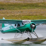
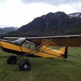
As an example I’ll cite my recent trip to Alaska. My friend and I had flown to a glacier that was calving into the ocean. We landed the beach to enjoy the sights and sounds. The tops of the surrounding mountains were under the clouds, the passes were clear. We probably watched the glacier for twenty minutes, when turning around to check for bears we noticed the clouds had lowered and the mountain tops were obscured. We beat a hasty retreat to the plane and by the time we were in and the plane was running the mountain passes were nearly obscured. Once in the air they were completely obscured. We had two choices, land back at the beach and wait it out, or we could fly out of the bay and along the coastline to Seward, which we did. Along the way the visibility would drop and rise and drop and rise, but never beyond minimums. With time on my hands in the back seat I imagined how we could find ourselves closed out and be forced to land in the ocean as close to the cliffs as possible, and boy would that be cold, not to mention wrecking the plane.

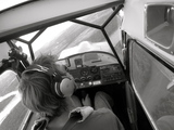
Or, we could use synthetic vision on my iPad. By the time I powered up the iPad and loaded Firelight we were landing at Seward where we took a break, made some phone calls and then launched inland. Here I decided to see if using Synthetic Vision could indeed allow someone to safely extract themselves from Inadvertent Flight into IMC, or if CFIT was inevitable.

I powered up Foreflight and launched Synthetic Vision in the split screen mode and here is what I saw.


Image

What? Where’s the terrain? Does Foreflight not work in Alaska? I launched Garmin Pilot and put it in Synthetic Vision (no split screen option) and here is what I saw.

Image

Now I was confused, why does Garmin Pilot Synthetic Vision have terrain in Alaska, but not Foreflight Synthetic Vision? Back at the house I learned that Foreflight’s US Alaska Terrain is a separate download from US Contiguous. Garmin Pilot makes no such distinction. Important lesson learned here, be sure you know you’ve download everything you need before taking off. In my defense I rarely use Foreflight, favoring Garmin Pilot for a few of its unique features, even though I think Foreflight is a far superior product. In this case I switched preference to Foreflight because of its spit screen capability.

Anyway, as we can see, Synthetic Vision can give us what we need to remain clear of terrain should we find ourselves in Inadvertent flight into IMC, assuming of course you can maintain the aircrafts flight attitude. Adding an AHRS module to either Garmin Pilot (GDL39) or Foreflight (Stratus) would give us an attitude display within the Synthetic Vision.

The cost is minimal, an iPad and a subscription to Foreflight Pro with SV add-on or Garmin Pilot with US VFR add-on.

Of course if we want to be good with Synthetic Vision we need to practice with it. But who wants to look inside the cockpit unless absolutely necessary? Enter X-Plane Flight Simulator Software. Install it on your Laptop, interface it with Foreflight on you iPad, choose realtime weather or specify your own, and practice away. Note: I’m not a computer game guy, not at all, but X-Plane is really cool for practicing IFR flying, and flying with Synthetic Vision.

How many of the souls who’ve perished in CFIT accidents would be alive today if the pilots had Synthetic Vision and knew how to use it. Of course they shouldn’t have gotten into Inadvertent Flight into IMC to begin with, but they’re human just like the rest of us, and humans make mistakes.

I know I’ll be doing a little Synthetic Vision flying practice on X-Plane before my next trip to the mountains.
Barnstormer offline
Posts: 2700
Joined: Sun Oct 14, 2012 7:42 am
Location: Alaska
Aircraft: C185

Re: CFIT & Synthetic Vision

.
Barnstormer said:

The cost is minimal, an iPad and a subscription to Foreflight Pro with SV add-on or Garmin Pilot with US VFR add-on.

Exactly. Who drives a car these days without GPS, or at least the capability if needed ? Talk about CFIT in AK, who can ever forget what happened to Alaska's first senator, Ted Stevens .

Image
Image
Image
I also think you touched on something very important when you mentioned that the Synthetic Vision did not work at first with the Foreflight example. Check all systems and check them again. I just hate it when a flashlight does not work. I usually have several backup flashlights even in my cars and truck. For flying, maybe even a back up SVX is worth considering. When the proverbial "you know what" hits the fan, that dinky electronic gadget could save the day.

Everyone should fly with, among other things, a roll of duct tape, a quality Swiss Army knife, and a flashlight. I think I'll add a portable SVX solution.

Thanks for scaring me this morning with your post. 8) . But it is a healthy scare. I need to carry really good small portable solution when I go flying with friends, now that prices are so reasonable.

Okay Android and Apple ...let's see what's available here in July 2015.
Last edited by Denali on Sat Jul 18, 2015 1:22 pm, edited 1 time in total.
Denali offline
User avatar
Posts: 809
Joined: Sun Sep 16, 2012 1:30 am
Location: East Coast USA

Re: CFIT & Synthetic Vision

I have been thinking a lot about this lately.

The thing is, we have been putting better technology in planes for a while ie the capstone system, synthetic vision etc....but CFIT rates have remained pretty constant in AK. Sometimes the technology is getting pilots in trouble instead of getting them out of trouble. Folks are flying in stuff they would never dream of when they didn't have the GPS, or even it it wasn't working.

This is not an anti-technolgy rant, it is a "let's think about it" rant. If you are thinking of launching into conditions that are less than optimal or can deteriorate (I guess they always can) I guess the question should be "would I launch without a GPS, SVX etc?", if anything to be honest with yourself as to level of reliance on the technology for the safety of yourself and your clients/passengers.

As to a back up Synthetic vision, my thought is that if you are having to use SVX and it goes out, your probably will have time to power up your backup before you hit the big green thing, spend the money on gas.

I have had two different GPS go out on me for no apparent reason during bluebird days, so may faith is not as strong as some.
Headoutdaplane offline
User avatar
Posts: 526
Joined: Thu May 29, 2008 5:21 pm
Location: Homer, AK
The winner is the person with the most stories when he dies, not the most gold.
www.belugaair.com

Re: CFIT & Synthetic Vision

There is no way I will fly in IMC in the mountains relying in Syntethic vision alone.
I need to know the route first and have waypoints marked on a VFR day.

I fly in IMC in the mountains sometimes to go to my uncle's farm, its a I route I have done many times in VFR and made waypoints with the altitude 500 ft above ground level on a clear day, the name of the waypoint is the altitude.
Also have a final waypoint 1 mile from the strip and a miss approach waypoint.
The Garmin 430 with the autopilot works nicely, and also have a Garmin 796 showing 3 D terrain.
motoadve offline
User avatar
Posts: 1423
Joined: Wed Aug 18, 2010 8:29 am
Location: Issaquah
Aircraft: Cessna 182P
CJ 6 Nanchang
Cessna 170B

Re: CFIT & Synthetic Vision

Barnstormer wrote:In my defense I rarely use Foreflight, favoring Garmin Pilot for a few of its unique features, even though I think Foreflight is a far superior product. In this case I switched preference to Foreflight because of its spit screen capability.


Good post Barnstormer. The Bendix King AV8OR my dad had in his cub recently died, so I spent quite a bit of time trying to figure out which app and tablet to go with as a replacement. We ended up choosing a Nexus 7 with GDL 39 and Garmin Pilot. Would have preferred Apple hardware, but even an iPad mini was too wide to fit where it needed to go.

Anyway, I'm curious why you prefer and primarily use Garmin Pilot, but think that Foreflight is superior?

On a somewhat unrelated note, it was nice to read yesterday that Garmin is going to allow Foreflight to interface with their panel mounted hardware (but not the GDL 39). Now if only they would hurry up and release SV on the android version of their app...
Last edited by NoCOpilot on Sat Jul 18, 2015 2:01 pm, edited 3 times in total.
NoCOpilot offline
User avatar
Posts: 86
Joined: Thu Mar 17, 2011 9:47 pm
Location: Fort Collins

Re: CFIT & Synthetic Vision

Who drives a car these days without GPS, or at least the capability if needed ?

I do. Map and compass has never failed me in car, airplane or on foot.

There are two major causes of CFIT - Inadvertent Flight into IMC, and rapidly rising terrain. Let's focus on Inadvertent Flight into IMC.

The C in CFIT stands for 'Controlled". My opinion is VFR flight into IMC then hitting terrain is Uncontrolled Flight Into Terrain.
tcj offline
User avatar
Posts: 1278
Joined: Thu May 29, 2008 12:52 pm
Location: Ellensburg, WA
tcj

Re: CFIT & Synthetic Vision

A telling statistic of AK, in the lower 48 CFIT occurs 90% on Take off or Landing, in AK it happens 90% in the cruise portion of flight.
Headoutdaplane offline
User avatar
Posts: 526
Joined: Thu May 29, 2008 5:21 pm
Location: Homer, AK
The winner is the person with the most stories when he dies, not the most gold.
www.belugaair.com

Re: CFIT & Synthetic Vision

.
I do. Map and compass has never failed me in car, airplane or on foot.

Image

Interesting. I think I have had everything, including the stars and GPS, fail me.

Before I got my first car GPS I used maps, and at night would sometimes crank down the window and navigate N-S-E-W by the stars because astronomy is one of my other passions. Works great, except daytime or when all cloudy at night. Although my car has GPS and a compass, for fun I do look at sun shadows, and can guestimate remaining daylight via 15 degrees per hour of sun above the horizon. Works great, except when raining, snowy, or all cloudy.

I have maps in the car, but sometimes they are the wrong scale. I was recently driving around in rural West Va., and had a local county map from years ago, but they are hard to get, and not updated regularly. So the maps have failed me.

My SOS tool kit in every vehicle includes a small old fashioned compass. I have a couple of old Bruntons from my geology days back during the Triassic. :) I have never resorted to using them, and some are probably magnetized to all hell by now.

I guess I have had everything fail me, and I can see how a map or compass might as well. I started flying when there was no GPS, so I appreciate the emphasis on maps, compasses, and plain looking out the window. It's just my philosophy that they all can fail. In my opinion, Synthetic Vision though is one development that's a real game changer as far as an added margin of safety. A portable Synthetic Vision solution is on my buy list for 2015.
Denali offline
User avatar
Posts: 809
Joined: Sun Sep 16, 2012 1:30 am
Location: East Coast USA

Re: CFIT & Synthetic Vision

So far I haven't used my Foreflight SV much. On this flight to OSH, it didn't occur to me. What little I've used it around home, it seems pretty unrealistic , but that's all been in the flats--maybe it will be more realistic in the hills.

Cary
Cary offline
User avatar
Posts: 3801
Joined: Sun Jan 10, 2010 6:49 pm
Location: Fort Collins, CO
"I have slipped the surly bonds of earth..., put out my hand and touched the face of God." J.G. Magee

Re: CFIT & Synthetic Vision

NoCOpilot wrote:...Anyway, I'm curious why you prefer and primarily use Garmin Pilot, but think that Foreflight is superior?...

For me sectionals provide way too much information and as a result are cluttered, making them difficult get information in flight quickly.

Garmin Pilot has a "VFR Map" which is a Terrain Map (not to be confused with the Terrain Alert feature) on which they overlay configurable "smart" airspace and airports. In addition the topography colors are richer.

Unfortunately there are no non-chart displays in Foreflight that include airports and airspace. And Foreflight's Terrain Map (beyond currently viewed areas) is only available when connected to the Internet.

The other reason I prefer Garmin Pilot is their radar weather display. To me it has greater detail which helps me determine if I need to avoid or if it's safe the fly through/under.

For these two reasons I almost always fly with Garmin Pilot.

Foreflight is far, far more feature rich, immensely easier to navigate menus, logically laid out, a lot easier to do flight planning, and much easier to check one's flight progress and make adjustments (while never leaving the map screen).

The first pic below is a screenshot of Foreflight, the second of Garmin Pilot.

Image

Image
Barnstormer offline
Posts: 2700
Joined: Sun Oct 14, 2012 7:42 am
Location: Alaska
Aircraft: C185

Re: CFIT & Synthetic Vision

@ Barnstormer

Image

Image

Image

AMEN 8)
Denali offline
User avatar
Posts: 809
Joined: Sun Sep 16, 2012 1:30 am
Location: East Coast USA

Re: CFIT & Synthetic Vision

Barnstormer, I didn't know about the VFR map, I just changed mine to that setting, it is awesome. I learned something today, I can check that box and have a beer.
Headoutdaplane offline
User avatar
Posts: 526
Joined: Thu May 29, 2008 5:21 pm
Location: Homer, AK
The winner is the person with the most stories when he dies, not the most gold.
www.belugaair.com

Re: CFIT & Synthetic Vision

Headoutdaplane wrote:Barnstormer, I didn't know about the VFR map, I just changed mine to that setting, it is awesome. I learned something today, I can check that box and have a beer.

Be sure you've downloaded the "High Resolution" Terrain Database (not the Medium Resolution).
Barnstormer offline
Posts: 2700
Joined: Sun Oct 14, 2012 7:42 am
Location: Alaska
Aircraft: C185

Re: CFIT & Synthetic Vision

I don't know what these new gadgets cost, but getting an instrument rating and then using it for cross country flying would be much safer. VFR flying that stays VMC and IFR flying that stays IMC are both very safe. It is the mix that causes CFIT. I can see synthetic as contributing to the mix.

I had the advantage, flying pipeline, seeing how much safer MVFR flying could be at 200' AGL. Most VFR into IMC CFIT starts at a couple thousand feet AGL or higher. In a helicopter that is trying to destroy itself or in an airplane encountering bad weather, getting down from 2,000' is more than most can handle. We can see so much better down low and we can get on the ground quickly. Call that stupid, but nobody dies.
contactflying offline
Posts: 4972
Joined: Wed Apr 03, 2013 7:36 pm
Location: Aurora, Missouri 2H2
Download my free "https://tinyurl.com/Safe-Maneuvering" e-book.

Re: CFIT & Synthetic Vision

FWIW, as cool as SV is, I would not trust it. Flying down the river valley the other day had me bouncing off the banks on one side and well clear on the other. It was maybe 100 feet off, but in those conditions 100 feet will kill you. This was on my 796.
A1Skinner offline
Supporter
User avatar
Posts: 5186
Joined: Sat Jan 21, 2012 11:38 am
Location: Eaglesham
FindMeSpot URL: [url:1vzmrq4a]http://share.findmespot.com/shared/faces/viewspots.jsp?glId=0az97SSJm2Ky58iEMJLqgaAQvVxMnGp6G[/url:1vzmrq4a]
Aircraft: Cessna P206A, AT402/502/602

CFIT & Synthetic Vision

The transition from visual to instruments is still a bitch even with SV. As cool as it is, I'm not sure there's much more of a chance surviving a 180 degree turn than with an altimeter and gyro if the pilot doesn't commit immediately, competently, and fully to instrument flight.

Flight sims are cool and good practice. Now if they could just figure out how to give a user vertigo and get the adrenaline pumping.

Please don't be tempted to push in further than you know you should just because you have a magic box without extensive experience with it. I don't mean to preach but they are scraping one up right now about 15mi E of where I am sitting here in my cozy living room. Pilot dead, 4 hurt passengers.
gbflyer offline
User avatar
Posts: 2317
Joined: Sun Oct 14, 2007 5:35 pm
Location: SE Alaska

Re: CFIT & Synthetic Vision

My post is about CFIT & Synthetic Vision specifically addressing Inadvertent flight into IMC, not flying IFR with Synthetic Vision, nor trusting it to guide one through the mountains.

It is about using it as a tool to provide a visual representation of the terrain around one should one find himself in an Inadvertent flight into IMC situation, providing a far greater opportunity of surviving then having no representation at all.
Barnstormer offline
Posts: 2700
Joined: Sun Oct 14, 2012 7:42 am
Location: Alaska
Aircraft: C185

Re: CFIT & Synthetic Vision

contactflying wrote:I don't know what these new gadgets cost, but getting an instrument rating and then using it for cross country flying would be much safer. VFR flying that stays VMC and IFR flying that stays IMC are both very safe. It is the mix that causes CFIT. I can see synthetic as contributing to the mix.

I had the advantage, flying pipeline, seeing how much safer MVFR flying could be at 200' AGL. Most VFR into IMC CFIT starts at a couple thousand feet AGL or higher. In a helicopter that is trying to destroy itself or in an airplane encountering bad weather, getting down from 2,000' is more than most can handle. We can see so much better down low and we can get on the ground quickly. Call that stupid, but nobody dies.

X2
M6RV6 offline
User avatar
Posts: 2313
Joined: Mon Feb 25, 2008 5:52 pm
Location: Rice Wa. 82WN Magee Creek AERODROME
FindMeSpot URL: http://share.findmespot.com/shared/face ... sWKXuhKlg2
Have as much Fun as is Safe, and Keep SMILIN! GT,

Re: CFIT & Synthetic Vision

I had a friend get upset at me when I didn't want to mount an iPad mini on my dash for synthetic vision "in case I ever punched in."

I can see how it could be helpful if rehearsed in that situation. My response was that I'd rather have a real gyro not dependent on a Wi-Fi or Bluetooth connection and that I just wouldn't punch in.


There's merits for synth vision in the circumstances of iimc, but I think there's a lot more merit to landing when you should and dealing with weather passing over you instead of trying to fly through it. Or to flying true IFR flight in situations where punching in could be life or death.

Just my 2 cents, take them for what they're worth.
CamTom12 offline
User avatar
Posts: 3705
Joined: Sun Jul 08, 2012 1:08 pm
Location: Huntsville
FindMeSpot URL: https://share.delorme.com/camtom12
Aircraft: Ruppe Racer
Experimental Pacer
home hand jam "wizard"

Re: CFIT & Synthetic Vision

Barnstormer wrote:My post is about CFIT & Synthetic Vision specifically addressing Inadvertent flight into IMC, not flying IFR with Synthetic Vision, nor trusting it to guide one through the mountains.

It is about using it as a tool to provide a visual representation of the terrain around one should one find himself in an Inadvertent flight into IMC situation, providing a far greater opportunity of surviving then having no representation at all.


Understood. But in the time it takes to boot it up trying to keep the greasy side down all the while, 90% of us (yes, us) are screwed. Especially in terrain. It is far different than using it on every flight, in the system, flight plan activated, waypoints and approaches loaded in and ready, and intimately familiar with its operation under stress, etc. No disrespect as one has no idea about other's individual levels of IFR experience. If we fly it a lot, the SV is a great tool. If we fly VFR all the time, with little real IFR experience, most of us will be a statistic if we lean on it when we've pushed too far, same as not having it.

I have full syn vis with ADAHRS system, HITS, geo-referenced sectionals, IFR enroutes and approach plates and high quality terrain files. It is scary accurate, as in right to the numbers if you're so inclined. I have found no real significant errors in mapping in my small operating area. The attitude indications are much more sensitive than any GPS based syn vis or old school gyros. I have found myself chasing it all over the place. It would take me at least 50 hours hood before I'd even consider it for real. If I had to use it today, for real, I'd be in trouble.

Again, experience levels vary, my own pain threshold is very low.
gbflyer offline
User avatar
Posts: 2317
Joined: Sun Oct 14, 2007 5:35 pm
Location: SE Alaska

DISPLAY OPTIONS

Next
38 postsPage 1 of 21, 2

Who is online

Users browsing this forum: No registered users and 2 guests

Latest Features

Latest Knowledge Base