
Coyote Flats, Ca. 37.2 North / 118.48 West
Sun Oct 30, 2005 5:22 pm
Coyote Flats, Ca. 37.2 North / 118.48 West
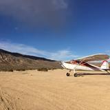
37.2 North / 118.48 West (Northeast of Fresno, CA - West of Bishop, CA) Resting high above Bishop, California, at an elevation of nearly 10,000’ is Coyote Flats. Very interesting "precautionary landing" location. About 45F OAT and 5 kts out of the north on arrival. It's do-able if ya' just keep an eye on the density altitude. More info at http://www.mountainflying.com/colin_2.htm
- retired user offline
- Posts: 710
- Joined: Sat Oct 01, 2005 7:07 am

Sun Oct 30, 2005 7:28 pm


Sun Oct 30, 2005 7:58 pm
You could camp there easy enough. It is high and dry. Not sure where the closest water would be. If I had more time I would have scouted around a bit. The dusting of snow has sure made the Sierra's beautiful right now. It also makes it look a bit less hospitable. If I can find time I'm going to post some more pictures etc. of my wanderings today. I hit Furnace Creek, Stovepipe Wells and Lone Pine along with Coyote Flats on my way back from Las Vegas. Great time of year to be flying. BTW, 100LL was 3.42 at North Las Vegas 
- retired user offline
- Posts: 710
- Joined: Sat Oct 01, 2005 7:07 am
Sun Oct 30, 2005 8:46 pm
These lakes are just over the ridge from Coyote Flats airstrip. Used to do a lot of fishin' in these lakes. I'd like to fly into the strip and walk over to the lakes (about eight miles of easy walking if memory serves me right) and camp and fish there again, but I worry what would happen to the plane while I was away from it. Mostly I worry about what the forest service would do to it if they came across it. This is really beautiful country.
The ridge on the right side of the photo is the one in the background with the snow on it in in N6EA's picture above.
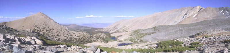
Looking east from the glacial moraine below Thunder & Lightning Lake towards Baker Lake, Twin Lakes et al. Coyote Flats is behind the mountain on the left side of the photo.
The ridge on the right side of the photo is the one in the background with the snow on it in in N6EA's picture above.
Looking east from the glacial moraine below Thunder & Lightning Lake towards Baker Lake, Twin Lakes et al. Coyote Flats is behind the mountain on the left side of the photo.
- Strata Rocketeer offline
- Posts: 504
- Joined: Sat Mar 26, 2005 11:19 am
"I've been ionized, but I'm okay now." - Buckaroo Bonzai
Mon Oct 31, 2005 5:49 am
That photo was taken by a friend of mine who still goes up there almost every summer - he sent it to me a couple of seasons ago to rub it in. According to the topo the hike is about five-six miles to Baker Lake. The Baker cabin is usable, and we've stayed in it a number of times. Rocky Bottom lake looks like it's only a couple of miles from the airstrip.
Coyote Flats Area Map
Coyote Flats Area Map
- Strata Rocketeer offline
- Posts: 504
- Joined: Sat Mar 26, 2005 11:19 am
"I've been ionized, but I'm okay now." - Buckaroo Bonzai
Wed Nov 02, 2005 7:17 am

Coyote Flat looking west toward Rocky Bottom Lake and Funnel Lake.

Baker Lake, Twin Lakes, Hidden Lake, Thunder and Lightning Lake, etc, etc, just south of Coyote Flat.
You could almost connect these two pictures together.
Anybody up for a backpacking trip next spring? Might be more strength in numbers.
- Strata Rocketeer offline
- Posts: 504
- Joined: Sat Mar 26, 2005 11:19 am
"I've been ionized, but I'm okay now." - Buckaroo Bonzai
Fri Jan 20, 2006 4:35 am
Coyote Flats
I get a lot of requests for info. re. the Coyote Flats airstrip near Bishop Ca. (BIH). It was the highest charted airstrip in the country at 9980' (not on the chart anymore). It is still there (less the asphalt).
There is also another strip in the valley South of Coyote which is much better and the wind in the afternoon is much better.
There is also another strip in the valley South of Coyote which is much better and the wind in the afternoon is much better.
Last edited by Desert Rat on Thu Feb 02, 2006 8:27 pm, edited 1 time in total.
- Desert Rat offline

- Posts: 260
- Joined: Thu Jan 19, 2006 6:10 pm
- Location: Big Pine Ca.
Fri Jan 20, 2006 9:42 am

- Desert Rat offline
- Posts: 260
- Joined: Thu Jan 19, 2006 6:10 pm
- Location: Big Pine Ca.
Thu Feb 02, 2006 8:24 pm
"Standoff" at Coyote Flats
They won....

- Desert Rat offline
- Posts: 260
- Joined: Thu Jan 19, 2006 6:10 pm
- Location: Big Pine Ca.
Sun May 13, 2018 4:09 pm
Re: Coyote Flats, Ca. 37.2 North / 118.48 West
Coyote Flats is in good shape.


Mon May 14, 2018 6:58 am
Re: Coyote Flats, Ca. 37.2 North / 118.48 West
Awesome! It is beautiful up there.
Wed May 16, 2018 9:44 pm
Re: Coyote Flats, Ca. 37.2 North / 118.48 West
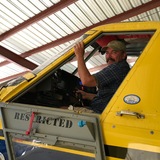
Coyote Flats is a great place! I did part of my summer field work there back in 76 for my Geology degree. Later I payed at the strip with an H46 that I was ferrying up to Fallon from the NARF. I essentially lived up there a month during the field work, only going back to our temp base at Big Pine so we could enjoy the fabulous restaurant, called "EAT." No airplane pics, but here is me in the old Series III diesel Land Rover crossing the mighty torrent running off the hills. The weather can change fast up there. We ended our field season there when a rather sudden and violent thunderstorm system partially (mostly) washed away the road up, essentially cutting it off for the duration.

Thu Jul 19, 2018 4:14 pm
Re: Coyote Flats, Ca. 37.2 North / 118.48 West
This airstrip is technically open and operating but under the jurisdiction of the National Forest Service which is woefully underfunded and understaffed. Unfortunately the temp staff will not issue permission to renovate it (for the last 6 years of attempts trying to obtain it).
If you are a fan of, and / or recently landed at this strip, please call the Bishop District Ranger Linda Riddle at (760) 873 2515 and tell her that this open, public airstrip is in need of renovation (even though it's currently landable) - the more people call, the more they will be pressured to issue a permission to go up there and put in a windsock, pull weeds, widen it and give it all the length it has.
At 10k' elevation, every foot is appreciated.
Thu Apr 25, 2019 11:42 am
Re: Coyote Flats, Ca. 37.2 North / 118.48 West
Any reasonably current news/photos? Snowy, clear, or ???
Thu Apr 25, 2019 12:27 pm
Re: Coyote Flats, Ca. 37.2 North / 118.48 West
That area got more snow this year than normal. I am sure there is plenty of snow.iPat wrote:Any reasonably current news/photos? Snowy, clear, or ???
- qmdv offline

- Posts: 3633
- Joined: Wed Feb 15, 2006 10:22 pm
- Location: Payette
- FindMeSpot URL: http://share.findmespot.com/shared/face ... I5tqEOk0rc
- Aircraft: Cessna 182
Thu Apr 25, 2019 6:58 pm
Re: Coyote Flats, Ca. 37.2 North / 118.48 West
It's on my short list. It'll likely be snow covered until Late summer. Mammoth ski resort will be open until at least July 4. CF is an autumn objective.
P
P
- Pierre_R offline


- Posts: 312
- Joined: Mon Sep 30, 2013 3:17 am
- Location: Minden, Northern Nevada
- FindMeSpot URL: https://share.findmespot.com/shared/fac ... 5KFquxzBYq
- Aircraft: 1964 C182 IO550 on Aerocet 3400's.
Aerotrek A220.
TBM 850
Thu Apr 25, 2019 10:55 pm
Re: Coyote Flats, Ca. 37.2 North / 118.48 West
Did some T&G's there last fall on the way home from HSF. Was not in bad shape. Hope to truly visit later this year when the snow finally melts off.
Flying Fiddler
Mon Jul 06, 2020 7:37 am
Re: Coyote Flats, Ca. 37.2 North / 118.48 West
https://youtu.be/XO7wchmjStw
Here is a video taken from the north end last January. Very beginning of the video is at the end of the runway looking down runway towards the south. Doesn't look like much of a runway anymore but it's certainly doable. 10,000ft, be aware of DA. Landed south to north, 32°F no wind, 2 people (310lbs), 70 gallons of fuel, 2,200lb empty weight NA 520 A36. That's about the limit there for my "bush plane"
Here is a video taken from the north end last January. Very beginning of the video is at the end of the runway looking down runway towards the south. Doesn't look like much of a runway anymore but it's certainly doable. 10,000ft, be aware of DA. Landed south to north, 32°F no wind, 2 people (310lbs), 70 gallons of fuel, 2,200lb empty weight NA 520 A36. That's about the limit there for my "bush plane"
Mon Jul 06, 2020 8:06 pm
Re: Coyote Flats, Ca. 37.2 North / 118.48 West
Really cool to see an A36 in there!
DISPLAY OPTIONS
Who is online
Users browsing this forum: No registered users and 5 guests
Latest Features
-
Live to Tell
A Minnesota pilot is surprised to learn that the sudden asymmetric drag of an out-of-rig ski can…Read More -
Creators
Working in some of the Yukon's most beautiful and remote environments, photographer Simon Blakesley captures aircraft in…Read More -
Aircraft Ownership and Maintenance
Upgrading to big tires can make a huge difference in backcountry performance, but with those gains come…Read More -
Tales from Yesteryear
In this tale from bush flying yesteryear, Don Cogger signs up to help Atlee Dodge Jr recovery…Read More


Latest Knowledge Base
-
Destinations
A regional guide with ideas for winter camping destinations in California, Nevada, New Mexico, and Arizona.Read More -
Aircraft
Finding an affordable aircraft that can handle the backcountry for $80K or less? A challenge for sure, but with the…Read More -
Aircraft
01.29.2018 - Zane - Updated tire diameter graphic to add 8.50x10 Guide to tires for use in the backcountry and off-airport landing…Read More -
Pilots
12.22.2013 - Initial article format Operating aircraft on skis and negotiating a snow-covered landscape is an entirely unique skillset and environment.…Read More


