Saw this from the air: not one but two gravel runways crossing at 100 degrees, obviously someone's private airport. It looks fosaken, but still has a windsock in a decent shape. Google Maps has older aerial photos where it seems in a better shape and shows an airplane parked near the house. Does anyone know the story?
To find the airport, follow the railroad on the other side of the I-25. The property is right next to railroad, with a driveway off Arrow Hondo Trail.
Fly-in Ranch - UNKNOWN - Santa Fe - NM
Wed Mar 06, 2013 6:33 pm
Fly-in Ranch - UNKNOWN - Santa Fe - NM
Last edited by zaitcev on Sun Mar 10, 2013 2:41 pm, edited 1 time in total.

Wed Mar 06, 2013 9:06 pm
Re: Fly-in Ranch - UNK - Santa Fe - NM
I saw that from the train a while back. Looked at Google Earth and those are long strips!
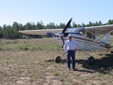
There is a plane at the house north of there - quite a taxi.
I'll be in Santa Fe next month and if I have time I may drive out there.
Very close to town. I will post if I find out anything.
There is a plane at the house north of there - quite a taxi.
I'll be in Santa Fe next month and if I have time I may drive out there.
Very close to town. I will post if I find out anything.
Thu Mar 07, 2013 10:48 am
Re: Fly-in Ranch - UNK - Santa Fe - NM
Are you talking about this one?
35.611, -105.959
35.611, -105.959
Thu Mar 07, 2013 3:37 pm
Re: Fly-in Ranch - UNK - Santa Fe - NM
Do you have coordinates? Tried searching Arrow Hondo Trail in SF, nothing came up. UNK is the identifier for Unakleet AK.
Thu Mar 07, 2013 5:00 pm
Re: Fly-in Ranch - UNK - Santa Fe - NM
Arroyo Hondo
35.3639
105.5731
35.3639
105.5731
Fri Mar 08, 2013 8:31 am
Re: Fly-in Ranch - UNK - Santa Fe - NM
35° 36.668'N 105° 57.467'W
Sun Mar 10, 2013 2:41 pm
Re: Fly-in Ranch - UNKNOWN - Santa Fe - NM
Indeed 35.611, -105.959 and 35° 36.668'N 105° 57.485'W refer to about the same place, which is what picquied my interest.
Mon Mar 11, 2013 9:45 am
Re: Fly-in Ranch - UNKNOWN - Santa Fe - NM
Google Earth shows a plane at the house nearby. So it might be in use.
Good find. I will ask around about ownership and if I come up with anything, will get back to you.
Thanks, Larry
Good find. I will ask around about ownership and if I come up with anything, will get back to you.
Thanks, Larry
DISPLAY OPTIONS
Who is online
Users browsing this forum: No registered users and 1 guest
Latest Features
-
Live to Tell
A Minnesota pilot is surprised to learn that the sudden asymmetric drag of an out-of-rig ski can…Read More -
Creators
Working in some of the Yukon's most beautiful and remote environments, photographer Simon Blakesley captures aircraft in…Read More -
Aircraft Ownership and Maintenance
Upgrading to big tires can make a huge difference in backcountry performance, but with those gains come…Read More -
Tales from Yesteryear
In this tale from bush flying yesteryear, Don Cogger signs up to help Atlee Dodge Jr recovery…Read More


Latest Knowledge Base
-
Destinations
A regional guide with ideas for winter camping destinations in California, Nevada, New Mexico, and Arizona.Read More -
Aircraft
Finding an affordable aircraft that can handle the backcountry for $80K or less? A challenge for sure, but with the…Read More -
Aircraft
01.29.2018 - Zane - Updated tire diameter graphic to add 8.50x10 Guide to tires for use in the backcountry and off-airport landing…Read More -
Pilots
12.22.2013 - Initial article format Operating aircraft on skis and negotiating a snow-covered landscape is an entirely unique skillset and environment.…Read More


