Johnson Creek IFR yet again
Mon Jul 23, 2007 9:16 am
Thu Jul 26, 2007 11:09 am
Here's the cause:

This fire is about 1 mile to the east of Johnson Creek, burning up Reardon Lake.
I haven't even seen Johnsson Creek in a week.
This fire is about 1 mile to the east of Johnson Creek, burning up Reardon Lake.
I haven't even seen Johnsson Creek in a week.
- LowAndSlow offline
- Posts: 161
- Joined: Wed Feb 15, 2006 9:27 am
- Location: Medford, OR
Thu Jul 26, 2007 10:13 pm
Whoa! John.
Hey nice picture of that smoke. 
In the late 70's I was a ground pounder on a couple of dudes like that. One fire we lost over 8000 acres of timber. Wind came up and started to crown, I spent 7 hours neck deep in a little pond with about 20 other fire fighters. Saying to myself WTF am I doing here!
Thanks for the updates and pictures, keep'em coming when you have a chance. Since I imagine your working your tail off.
Be safe, Bub
Robert "Bub" Wright, aka Skylane, passed away in November of 2011. He was a beloved community member and will be missed.
Fri Jul 27, 2007 6:57 am
Fri Jul 27, 2007 1:10 pm
There isn't a TFR there, but IMO, there should be. This morning 3 planes (I was in trail) climbed up Indian Creek right into a swarm of 2 SEATs, a leadplane and air attack. Nobody was talking on the radio, and nobody had been flying it all week. So that was a little surprising. If you're going to work a fire, put up a TFR, that's what they're for.
We finaly got some rain in the area yesterday, and that cleaned up there air and calmed things down a bit. Maybe the USFS can get a couple of these reigned in a bit, we've still got a lot of summer left.
We finaly got some rain in the area yesterday, and that cleaned up there air and calmed things down a bit. Maybe the USFS can get a couple of these reigned in a bit, we've still got a lot of summer left.
- LowAndSlow offline
- Posts: 161
- Joined: Wed Feb 15, 2006 9:27 am
- Location: Medford, OR
Wed Aug 01, 2007 9:24 am
Yikes
Well it doesn't look like things are getting much better.
Low&Slow, John, do you have any updates on the fire situation?
Anything found out about your oil pressure issue on the 206?
Come on RAIN!
See ya, Bub
Low&Slow, John, do you have any updates on the fire situation?
Anything found out about your oil pressure issue on the 206?
Come on RAIN!
See ya, Bub
Robert "Bub" Wright, aka Skylane, passed away in November of 2011. He was a beloved community member and will be missed.
Wed Aug 08, 2007 7:21 pm
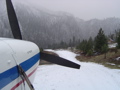
Just checked the JC website. It's the clearest I've seen it in days. Has the strip been closed? I saw that it was right on the edge of the TFR. Just curious.
L&S, how are things up that way? Getting better, worse, same? I really want to head up that way but I'm telling my friends that want me to take them that we may need to wait until the fires die down, i.e. late September/October. Hopefully it won't be that long.
L&S, how are things up that way? Getting better, worse, same? I really want to head up that way but I'm telling my friends that want me to take them that we may need to wait until the fires die down, i.e. late September/October. Hopefully it won't be that long.
- Grassstrippilot offline


- Posts: 3536
- Joined: Wed May 31, 2006 6:17 am
- Location: Syracuse, UT
- FindMeSpot URL: https://share.garmin.com/WolfAdventures
- Aircraft: Cessna 205
Thu Aug 09, 2007 6:03 am


Thu Aug 09, 2007 10:35 am
Not Bad
375,
Around Burns things aren't bad. A lot of SEAT activity going east about 25 miles and one fire south east about 65 miles.
So if you coming into BNO keep 122.8 tuned in to catch the traffic. SEATs have been taking off on 30 and landing 21. There is also a mix of Rotorheads.
I'm not sure of your route, but don't belive up though here you'd have any issues.
Hotshot would proably have good info on the Hells canyon fire since it's in his backyard.
See ya, Fly Safe, Bub
Robert "Bub" Wright, aka Skylane, passed away in November of 2011. He was a beloved community member and will be missed.
Thu Aug 09, 2007 7:25 pm
Tired of the smoke.
I wouldn't go to Johnson Creek. Heck, if it wasn't what put food on the table, I wouldn't even fly in Idaho right now. Every day is totally different than the one before. Some days it's clear, others it's 2 miles, which sucks when you're flying around tall mountains.
Some guy flying around in a Super Cub this morning called out on .9 asking if anyone had been into JC 'today.' I told him I hadn't even seen the strip in a month.
I'd watch the weather from home, wait 'till we get a good low pressure with some rain/snow, and then come visit Idaho. See what's left.
Take care,
John
- LowAndSlow offline
- Posts: 161
- Joined: Wed Feb 15, 2006 9:27 am
- Location: Medford, OR
Thu Aug 09, 2007 7:45 pm
Thanks for the update, John. I'm sorry it's not a happy one, though. From the fire maps, it looks like the whole confluence of the main Salmon and the South Fork of the Salmon has been burned over, including Mackey Bar and Wilson Bar. I sure hope that's not true, but the maps make it look grim, and there's no relief in sight.  Good luck, and thanks again for keeping us posted.
CAVU
CAVU
Thu Aug 09, 2007 9:39 pm
Bub et al:
Departed Santa Rosa, KSTS, direct for Grangeville, S80, at 12:45 PM PDT arrived 4:45 PM PDT. Flew at 11,500, 9,500, 7.500. Nice and bumpy all the way. Fires everywhere. No lightening. Dodged a few clouds, but not many. Landing at S80 was fun: 90 degree crosswind at 15-20 knots. I couldn't complain, though, the jumper planes and retardant planes had been landing there one after another like no big deal.
Good to be home, even if it is smokey.
375HandH
Fri Aug 10, 2007 1:29 pm
CAVU wrote:From the fire maps, it looks like the whole confluence of the main Salmon and the South Fork of the Salmon has been burned over, including Mackey Bar and Wilson Bar.
CAVU
The Main Salmon has been closed for the rest of the season to boaters. I think Mackey Bar made it. I've got a friend with a place up the South Fork, and the fire ran through there and burned several cabins. His made it, but he lost his generator shed and every single tree on his property. I don't think the fire is at Wilson yet, but I haven't been that way in a month. I've flown over the area several times, but you can't see the ground.
I heard Johnson Creek was clear this morning. I wouldn't do anything but go in and back out again though, you're likely to get stuck if you overnight.
The Middle Fork was about 1-3 miles this morning until the wind picked up.
John
- LowAndSlow offline
- Posts: 161
- Joined: Wed Feb 15, 2006 9:27 am
- Location: Medford, OR
Fri Aug 10, 2007 5:35 pm
- Grassstrippilot offline
- Posts: 3536
- Joined: Wed May 31, 2006 6:17 am
- Location: Syracuse, UT
- FindMeSpot URL: https://share.garmin.com/WolfAdventures
- Aircraft: Cessna 205
Sun Aug 12, 2007 7:40 am
Thu Aug 16, 2007 10:31 am
JCreek camera
Just wondering why the link at the top of this thread is still getting images from the JCreek camera and the http://www.ruralnetwork.net/~yellowpinecm/
Link says down for maint.?
Different link?
TD
Link says down for maint.?
Different link?
TD
Thu Aug 16, 2007 10:46 am
Re: JCreek camera
TomD wrote:Just wondering why the link at the top of this thread is still getting images from the JCreek camera and the http://www.ruralnetwork.net/~yellowpinecm/
Link says down for maint.?
Different link?
TD
The camera is probably still updating the image file on the server but they removed the image from the HTML on the page. I wonder why?
- Zzz offline


- Posts: 2855
- Joined: Fri Oct 08, 2004 11:09 pm
- Location: northern
- Aircraft: Swiveling desk chair
Half a century spent proving “it is better to be thought a fool than to open your mouth and remove all doubt.”
DISPLAY OPTIONS
Who is online
Users browsing this forum: No registered users and 3 guests
Latest Features
-
Live to Tell
A Minnesota pilot is surprised to learn that the sudden asymmetric drag of an out-of-rig ski can…Read More -
Creators
Working in some of the Yukon's most beautiful and remote environments, photographer Simon Blakesley captures aircraft in…Read More -
Aircraft Ownership and Maintenance
Upgrading to big tires can make a huge difference in backcountry performance, but with those gains come…Read More -
Tales from Yesteryear
In this tale from bush flying yesteryear, Don Cogger signs up to help Atlee Dodge Jr recovery…Read More


Latest Knowledge Base
-
Destinations
A regional guide with ideas for winter camping destinations in California, Nevada, New Mexico, and Arizona.Read More -
Aircraft
Finding an affordable aircraft that can handle the backcountry for $80K or less? A challenge for sure, but with the…Read More -
Aircraft
01.29.2018 - Zane - Updated tire diameter graphic to add 8.50x10 Guide to tires for use in the backcountry and off-airport landing…Read More -
Pilots
12.22.2013 - Initial article format Operating aircraft on skis and negotiating a snow-covered landscape is an entirely unique skillset and environment.…Read More


