×

Message

Please login first

Backcountry Pilot • Mt Iliamna

Mt Iliamna

Did you fly somewhere cool, take photos, and feel like telling the tale to make us drool from the confines of our offices? Post them up!
10 postsPage 1 of 1

Mt Iliamna

Yesterday's flight home was pretty spectacular. The crummiest flights don't get much photodocumentation, too much to concentrate on already. But the good weather draws the camera out for sure. We took off knowing that there were high clouds out on the Bristol Bay side and scattered layers here and there on the Cook Inlet side, but it was totally gorgeous in Anchorage.

We were aiming for a noon departure, so when it was a quarter after 11 I figured I better wake my wife up...needless to say we didn't leave at noon. We packed up our mess after having spent the night on the floor at our friends' house. Then identified what we were going to take with us, what could wait for the next flight (whenever that might happen), and what should be mailed since we don't know when the next trip in might be. You never do know with the sorts of weather we have and competing work responsibilities. Then we went to the post office, decided we better grab something to eat...(A date! Does Burger King count as a date?...) so we dropped in and ate at Burger King, then finally off to the airport.

At Merrill Field, we got everything out of the van that we were going to load up, then my wife headed off to park the van while I loaded the plane, preflighted it, and checked the weather (which was still awesome).

Finally, she showed back up so we loaded ourselves in and launched. A pair of warbirds, a T6 and a Zero, took off behind us in a flight of two to play around. The tower controller at Merrill 'suggested' a teardrop departure with a low pass over the airfield, which they were only two happy to oblige. Unfortunately it was all happening behind us as we crossed to Point Noname and headed out the powerlines to get through the busy airspace. But the controller came back on and cleared the warbirds out of his airspace, adding, 'thanks for the show."

We were having our own airshow in front of us, because it was a beautiful Saturday with perfect weather, so every weekend warrior in the Anchorage bowl was out flying. And the Jets were taking off to the north at International, so everybody was hanging out down low to maximize wake turbulence separation. My wife got really good at spotting airplanes, she saw a few before I did on this flight.

After we made it to the mouth of the Susitna River, we started our climb, but soon found ourselves under a scattered layer at 3500 feet. I was looking for a good path to climb above it, but it rose as we went, so we ended up at 6500 feet without getting above it. At that point, we could see under it to Redoubt, but the top of Redoubt was shrouded, and it looked like the same story down at Mt Iliamna, so I was thinking we were going to have a change of plans. The weather was really nice, so perhaps we would fly the coast down to Bruin Bay, then across.

But just after making that decision and preparing to descend to 3000 for a better view of the coast, we got a clear line of sight to Mt Iliamna and it was completely open...except for a self-made cloud at the summit.
Image

From the mountain, there are glaciers in all directions. But the one that runs straight down toward Cook Inlet is covered with grime at the lower end, or maybe it is something that has a more proper name, like dirt, or even rock sludge...
Image

South of Mt Iliamna, it has three sisters that come off its flank. Here they are.
Image

Termination dust was apparent on the high ridges after we passed the 3 sisters.
Image

Image


The upper end of Chinitna Bay was dappled in sunlight coming through the dappled clouds that we had to duck back under, as the layer was most open right around Mt Iliamna.
Image

As we looked ahead, we could see down the coast a long way on one side and we could see the coast on the other side...

My wife pointed to the west. "What is that?"

"That's Lake Iliamna."

We flew toward Pile Bay, then Intricate Bay, and over Kokhanok we decided to take a detour and fly down Funnel and Moraine Creeks. Past Iliamna Lake, I took a photo of the high tundra country.
Image

The creeks were quiet, but there were still a view bears visible on them. We headed on past the outlet of Nonvianuk Lake.
Image

From there, it was past Sugarloaf, and on to home. What a great flight. I should do that again sometime.
Troy Hamon offline
User avatar
Posts: 913
Joined: Tue Apr 06, 2010 8:27 am
Location: King Salmon
FindMeSpot URL: http://share.findmespot.com/shared/face ... 04iX0FXjV2
Aircraft: Piper PA-22

Re: Mt Iliamna

Stunning! =D>
denalipilot offline
Supporter
User avatar
Posts: 2789
Joined: Mon Oct 15, 2007 4:53 pm
Location: Denali
Aircraft: C-170B+

Re: Mt Iliamna

Great TR, Troy! Well written as always, and great photos.
Zzz offline
Janitorial Staff
User avatar
Posts: 2855
Joined: Fri Oct 08, 2004 11:09 pm
Location: northern
Aircraft: Swiveling desk chair
Half a century spent proving “it is better to be thought a fool than to open your mouth and remove all doubt.”

Re: Mt Iliamna

Good stuff! .... Thanks for the report!
low rider offline
User avatar
Posts: 778
Joined: Fri Nov 30, 2007 1:43 pm
Location: Tahoe
vail

Re: Mt Iliamna

Really great TR Troy!

That red roofed lodge at the mouth of the Nonvianuk is my uncles lodge..Royal Wolf, same goes for the mouth of the Big Ku.

Some of the largest rainbows in the world at Moraine creek! I think all the fish there are trained.. :)

Really great to see the snow up high.

Post more photos!

AKT
aktahoe1 offline
User avatar
Posts: 2052
Joined: Sun Jul 13, 2008 8:22 am
Location: Alaska and Lake Tahoe = aktahoe
If it looks smooth, it might be. If it looks rough, it is...www.bigtirepilot.com ...www.alaskaheliski.com

Re: Mt Iliamna

Awesome... :-)
Coyote Ugly offline
User avatar
Posts: 897
Joined: Thu Jan 03, 2008 9:51 pm
Location: Middle of Nevada (Middle of Nowhere?)
They used to say there are no old bold pilots, hell, looka here........

Track My Spot

Re: Mt Iliamna

Flew home this week late evening, had a great flight. Once again, I went over the top instead of through the pass. After a few years flying and not making it over the top one time, I have now been over the top a few times, at least six, not sure I remember. I'm going to have a lot of photos of Iliamna and Redoubt if I keep this up, so I may have to find another route just for other photo ops...

Approaching Redoubt, mountains above and below the wisps o' cloud.
Image

Image

Mount Redoubt.
Image

Image

Mt Iliamna.
Image

After passing Mt Iliamna, I got to watch the sun set off to the west. As happens sometimes in the winter, there was a good inversion developing, and the mountains in the far distance were stretched. I keep planning to take photos of a good mountain illusion in the winter, but I need to remember to carry a telephoto lens to make it work at all. And keep the camera around for a really good one, the awesome ones should show up with the lens I regularly use...

I arrived at PAKN a couple minutes after civil twilight and decided to make use of the opportunity to get night current. Wind was 36016G20. Normally I would land on 36 and be done with it. But since I was going to be doing four landings anyway (so I could have three night takeoffs...required for currency...) I decided to work on some crosswind landings at the same time, so I landed on 30. Definitely kept me thinking and aviating. Three landings, then on the third takeoff I circled around to land 36, which was a lot easier, and called it a night. Beautiful flight.
Troy Hamon offline
User avatar
Posts: 913
Joined: Tue Apr 06, 2010 8:27 am
Location: King Salmon
FindMeSpot URL: http://share.findmespot.com/shared/face ... 04iX0FXjV2
Aircraft: Piper PA-22

Re: Mt Iliamna

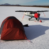
Saturday I flew with a friend to Wolf Lake airport in Palmer. It was severe clear, but as is usual, that was due to a north wind. On the ground, the north wind was fairly benign, but the winds aloft forecast was pretty brutal. I flight planned for 6,000 and 9,000 feet, and either of those would have taken us over 5 hours...which is more than the fuel on board (well, maybe not leaned to altitude...but I didn't want to test the maybe part of that statement...).

So we elected to hang down low, and after takeoff we were finding that 500 feet gave us about a 15 kt headwind, while 1,000 feet put us more in the realm of a 20+ kt headwind. Still better than the 35 kts at altitude though. Rather than fret and worry about fuel, we stopped in Iliamna to fuel up, then took off again. Our ground speed had been better than expected, usually near 80 kts, but the west side of Cook Inlet was supposed to be ripping from the northeast with turbulence below 2,000 feet, so we didn't want to be short on fuel as we were evaluating our options after the pass.

Flying over Port Alsworth, I realized I really hadn't ever taken a photo of the place from the air, so I remedied that.
Image

The wind was fairly benign from Port Alsworth to the middle of the pass, and our groundspeed was up close to 90 kts.
Image

As we passed the midpoint of the pass, we started getting an actual tailwind, and were showing groundspeed over 100 kts for a while. Got a few bumps in the Narrows and passing Big River Lakes, then turned and crested over the ridge toward MacArthur River and points northeast...and our groundspeed was 56 kts.

Oh boy.

Within a few moments of noticing that, it started getting pretty bumpy. I went up to 2,000 feet to see if that was better, and it smoothed out a bit, but we were still showing speeds generally below 60 kts, occasionally 50 kts. Seemed like it might be a really long trip up the inlet. Around Nicolai Creek, I decided to see if the lower altitudes had any smooth air or at least diminished headwinds, so we went down to 500' agl to check it out. Our groundspeed bumped over 60 for a bit, but then back down, and it was just bumpy enough to not be worth it without at least a 20 kt improvement. As I was deciding that, I looked and saw groundspeed of 50 again, and decided for that speed, I could ride some nice smooth air...so we climbed to 3,000 feet and it was smooth as butter. Flew 56-62 kts all the way to the mouth of the Big Su. At that point, I noticed that the speeds started to improve, and pretty soon we were seeing 70-80 as we passed Big Lake.

The automated weather at Wasilla was 21G26kts right down the runway. That gave us a good option in case we needed a backup. Palmer was reporting 26G37kts...not to my liking at all. Since this was my first trip to Wolf Lake, I was wondering which of these sets of conditions will be more similar to what they have there?

Looking ahead, there was a huge plume of dust coming out of the Knik Glacier valley and whipping over Palmer to the southwest. At least Wolf Lake was out of the main thrust of that. As we passed over Wolf Lake at 3,000 feet, the wind was pretty well aligned with runway 6, but the sock was standing straight out and swaying back and forth a little more than I would have liked. We flew past the airport, descended, then turned and entered midfield left downwind for rwy 6. There was a taildragger of some sort, first though was a champ but I didn't spend a lot of time looking at what it was, that was sitting still with the prop spinning, perhaps warming up on a gravel area off the approach end of 6. He wasn't talking, so I kept an eye on him in case he was NORDO as I turned base then final. He never moved, so I looked up and noticed that we were in an uncommanded climb, caught a serious updraft right there on final. I iniated an immediate 360, and since we could verify visually that there was still nobody else in the pattern, we continued the 360 all the way around and re-established final at an appropriate altitude. With the amount of wind, it moved us back far enough to give us a good descent profile, and down we came.

The lower we got, the gustier and more entertaining it got. The plane off the approach end was still sitting there spinning his prop, so we flew on past to make our landing. Wolf Lake has a nice long runway, but it is pretty narrow. I could tell it was going to be fun, as the wind that was whipping down the runway was spilling over the trees into the open airport area and we were getting shoved around pretty good. I kept myself tracking straight, slowing the plane down while repeatedly getting back to center as a gust would push us to one side or another. As I looked ahead, I could see that the corrections were going to take us past the normal land on the numbers practice. In fact, we were sashaying back and forth, less than 20 agl, trying to establish a good smooth descent while the air was anything but smooth. A couple times we were nearly ready to touch down and a side gust would push us over and I'd have to add power and strong correction to keep us from wandering away from the runway. Twice we touched a tire but not in a safe landing movement and had to lift it back up, but finally steadied just long enough to realize that we were going to hit the go-around button if we didn't land in the next two hundred feet...but fifty feet later both mains made good straight contact, I pulled power, and there we were.

Wind? Definitely more like Palmer.

Wow.

Now I had the joy of backtaxiing in the wind. That's a popular way to stick a Tri-Pacer on its nose. So I moved very slowly and deliberately, putting in control inputs the instant we changed direction to need them. As we were taxiing directly downwind, I was thinking of one of those non-sequitur jokes...there I was, pushing the yoke all the way forward. I imagined a passenger asking why I was holding the yoke so far forward...so I could have responded..."Because I can't hold it any farther forward!" And perhaps equally important, we didn't go too fast. I was happy to taxi into the lee side of our friends hangar and get out. Whew.

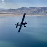
Sunday, we came back in the evening. The wind had died down, and was enough from the side that we didn't have much of a tailwind, but it was diminished enough that it was faster to go over the top than through the pass, so we climbed up to 7,500 to get a good look at the volcanoes again.

Mt Iliamna in the distance past the slopes of Redoubt.
Image

Mt Redoubt, smoking away.
Image

Cook Inlet and Kalgin Island.
Image

Rock and ice face on Redoubt.
Image

Tuxedni Bay and Mt Iliamna.
Image

Glacier coming down off Iliamna, which is steaming away.
Image

And finally, the moon over the mountain...
Image

The sun was going behind the clouds as we passed the volcanoes, which is probably obvious from the light in the photos. I had been keeping track of forecasts to see if we needed to leave earlier, but we had a quarter moon and King Salmon was forecast to have a ceiling greater than 12,000 feet, so I was mostly interested in getting over the mountains in good light, which is what we did. As we passed Igiugig, it was getting dark, but we could see the lights of Igiugig from our cruising altitude of 6,500 feet even while it was still quite light, as the rotating beacon is pretty easy to see. We could see Levelock by the time we passed Igiugig. And as we passed Igiugig both King Salmon and Naknek came into view, as it was just getting dark enough for the lights to stand out.

I always like to know my options, and there were some low clouds over Lake Iliamna as we came over the mountains, so I had tuned in the Iliamna automated weather as we neared Pile Bay, and Iliamna was very good, so we had an alternate if needed. By the time we got to Pedro Bay we could see Iliamna, and tuned in the automated weather for Igiugig, which was even better, and we could nearly see it already. So we already knew we'd make it no problem to Igiugig.

Well, as we neared Igiugig over Kukaklek Lake, we picked up King Salmon weather and it was stellar. We could see that by then, but the official weather is always reassuring. The wind was calm, so from about 30 nm out we started our descent, and as we were 10 miles out I told my passenger to watch for magic, then turned on the runway lights...and she didn't even see them. So as we got closer I dimmed them, then put them on bright again. Then she saw them. I don't think she was very impressed. I love watching runway lights come up. Oh well.

The wind was calm, so a lovely flight ended with a lovely landing and then, after being dressed for cold, unloading the plane made me hot. It was 26 degrees and hot out. Must be winter.

Good flights all.
Troy Hamon offline
User avatar
Posts: 913
Joined: Tue Apr 06, 2010 8:27 am
Location: King Salmon
FindMeSpot URL: http://share.findmespot.com/shared/face ... 04iX0FXjV2
Aircraft: Piper PA-22

Re: Mt Iliamna

Vivid. Thank you!
8GCBC online
User avatar
Posts: 4623
Joined: Thu Aug 05, 2010 11:55 pm
Location: Honolulu
Aircraft: 2018 R44
CFII, MEI, CFISES, ATPME, IA/AP, RPPL, Ski&Amphib ops, RHC mechanic cert, RHC SC— 3000TT

Re: Mt Iliamna

Love mountain shots...these are fantastic! tks for sharing, cheers!
Backcountry Tundra offline
User avatar
Posts: 518
Joined: Sun Mar 27, 2011 9:12 pm
Location: Yukon Territory
FindMeSpot URL: http://share.findmespot.com/shared/face ... WH6oiFuJCR

DISPLAY OPTIONS

10 postsPage 1 of 1

Who is online

Users browsing this forum: No registered users and 1 guest

Latest Features

Latest Knowledge Base