Near Mt. Barcroft 12,000' N37 33' W118 14'


Desert Rat wrote:The Coyote Flats airstrip is at 10,000'. The pix. on the ridge is West of there. It has a good camping area but no trees that high. Very open and uphill landing. Easy to see. Probably about a 10% slope.
EZFlap wrote:Desert Rat wrote:The Coyote Flats airstrip is at 10,000'. The pix. on the ridge is West of there. It has a good camping area but no trees that high. Very open and uphill landing. Easy to see. Probably about a 10% slope.
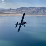
I think the "pics on the ridge" near Mt. Barcroft would be East of Coyote Flats? Coyote Flats is on the Sierra Nevada side (W side of Owens Valley), and Barcroft is in the White Mountains on the East side of the valley. In your photo of the airplane with the snow capped peaks in the background, on the very right side of the photo there are the green fields several miles northwest of Bishop,and the peaks in the photo definitely look like the Sierra instead of the Whites.


Desert Rat wrote:
This is Coyote Ridge Airstrip which is 11,700' and a couple of miles West of Coyote Flats.
Over by Barcroft 12,000'
Users browsing this forum: No registered users and 1 guest