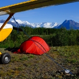
A: My 172 on the way to Johnson Creek!
I've always taken the same route. Tonight, I was looking at other routes in case I might want to come in some time from a different direction. That got me to thinking that there might be people on here who have never been there and would be interested in seeing the canyon flying that is involved.
Here's the route I've always taken:
http://www.runwayfinder.com/?loc=myl;44.923/-115.950;45.048/-115.928;45.075/-115.782;44.945/-115.605;44.960/-115.505;3U2
If you click on the white "terrain" button in the upper right corner of the map, you will get a shaded, topographic map with much higher resolution than the VFR chart. Then, you can zoom in and really see the canyons.
I'd be interested in knowing what routes other people take, and how well they can accomodate lower horsepower planes.
Q: What has six legs and a square tail?
Tue May 25, 2010 11:15 pm
Wed May 26, 2010 5:41 am
Re: Q: What has six legs and a square tail?
Does not open for me
Tim
Tim
- qmdv offline

- Posts: 3633
- Joined: Wed Feb 15, 2006 10:22 pm
- Location: Payette
- FindMeSpot URL: http://share.findmespot.com/shared/face ... I5tqEOk0rc
- Aircraft: Cessna 182
Wed May 26, 2010 9:58 am
Re: Q: What has six legs and a square tail?
qmdv wrote:Does not open for me
Tim
Opens perfectly for me.
Has anyone noticed that Google has integrated the Google Earth functionality into their web based Maps? If you open maps.google.com, search for "yellow pine, id", you'll be taken to the classic 2D map centered on Yellow Pine. If you then select the "Earth" view mode from the upper right menu, it takes you into this mode where you can control your heading, camera angle, zoom, etc...all the cool stuff from Google Earth that lets you virtually fly down the canyon. It's nice to have that without having to fire up the actual GE application.
A word of caution though, it takes a little while to load in the browser.
- Zzz offline


- Posts: 2857
- Joined: Fri Oct 08, 2004 11:09 pm
- Location: northern
- Aircraft: Swiveling desk chair
Half a century spent proving “it is better to be thought a fool than to open your mouth and remove all doubt.”
Wed May 26, 2010 11:25 am
Re: Q: What has six legs and a square tail?
As an alternative, I like overflying Landmark and then flying the Johnson Creek drainage north up to Johnson Creek. Gives you lots of time to slow down and get down and puts you on the downwind leg.

Wed May 26, 2010 12:19 pm
Re: Q: What has six legs and a square tail?
Oregon180 wrote:As an alternative, I like overflying Landmark and then flying the Johnson Creek drainage north up to Johnson Creek. Gives you lots of time to slow down and get down and puts you on the downwind leg.
I have to agree on this one. Wannabe talked me into taking the southern route from McCall last time I flew into JC, and I liked it. You don't have to climb as high, and like Oregon180 said, it sets you up for a nice downwind entry to rwy 17 so that you can scope the field and find your parking spot prior to landing.
- Zzz offline
- Posts: 2857
- Joined: Fri Oct 08, 2004 11:09 pm
- Location: northern
- Aircraft: Swiveling desk chair
Half a century spent proving “it is better to be thought a fool than to open your mouth and remove all doubt.”
Wed May 26, 2010 12:28 pm
Re: Q: What has six legs and a square tail?
Oregon180 wrote:As an alternative, I like overflying Landmark and then flying the Johnson Creek drainage north up to Johnson Creek. Gives you lots of time to slow down and get down and puts you on the downwind leg.
That looks like a good route. I think I'll try it this summer. Anything that precludes climbing over higher terrain and has a road in the bottom is always desirable.
Roads aren't just good for emergencies, they can also be a good navigation aid. I've talked to a few pilots over the years who have told me they flew up the wrong canyon trying to get from JC to Big Creek. It was always the same canyon, due north of Yellow Pine, about a mile to the west of the one they should have taken. It's hard to see on the chart, but there is a road that goes up the correct canyon, and if they had known that and had taken care to follow it, they wouldn't have made that potentially deadly mistake. Of course, the "interesting" strips never have roads in the vicinity!
Wed May 26, 2010 5:48 pm
Re: Q: What has six legs and a square tail?
kevbert wrote:Oregon180 wrote:As an alternative, I like overflying Landmark and then flying the Johnson Creek drainage north up to Johnson Creek. Gives you lots of time to slow down and get down and puts you on the downwind leg.
That looks like a good route. I think I'll try it this summer. Anything that precludes climbing over higher terrain and has a road in the bottom is always desirable.
Roads aren't just good for emergencies, they can also be a good navigation aid. I've talked to a few pilots over the years who have told me they flew up the wrong canyon trying to get from JC to Big Creek. It was always the same canyon, due north of Yellow Pine, about a mile to the west of the one they should have taken. It's hard to see on the chart, but there is a road that goes up the correct canyon, and if they had known that and had taken care to follow it, they wouldn't have made that potentially deadly mistake. Of course, the "interesting" strips never have roads in the vicinity!
kevbert - I can't make the fly-in in June, but am planning a trip to Idaho (Idaho Falls/Jackson, WY/Hailey) to visit family in July, and I'd like to visit JC then ... so am wondering about an approach from the southeast .... you or anybody else here made it in to JC from that direction?
Any advice to offer?
"Sometimes the magic works, and sometimes it doesn't"
Chief Dan George, in "Little Big Man"
Chief Dan George, in "Little Big Man"
Wed May 26, 2010 6:27 pm
Re: Q: What has six legs and a square tail?
Have come into JC from the southeast..Arco, Hailey, Smiley Creek, Bruce Meadows, Landmark, JC. Have also come in several times from Cascade. Approach from up river...long downwind to land up river at JC. No real big mountains to fly over.
HC
HC
'05 7GCBC High Country Explorer
The faster I go , the farther behind I get.
The faster I go , the farther behind I get.
Sat May 29, 2010 6:15 pm
Re: Q: What has six legs and a square tail?
I like the Landmark and fly down Johnson Creek route into Johnson Creek.
1959 Cessna 182 Skylane N9054N
My back country videos are here: http://www.youtube.com/skybobb
"I don't belong to any organized Political party, I'm a Democrat."
Will Rogers 1879 - 1935
My back country videos are here: http://www.youtube.com/skybobb
"I don't belong to any organized Political party, I'm a Democrat."
Will Rogers 1879 - 1935
Sat May 29, 2010 8:11 pm
Re: Q: What has six legs and a square tail?
yup on the south route. us local folks call in "big creek summit for johnson ck"
p.s. not the big creek you're think'in....
p.s. not the big creek you're think'in....

jomac
Sat May 29, 2010 11:22 pm
Re: Q: What has six legs and a square tail?
jomac wrote:yup on the south route. us local folks call in "big creek summit for johnson ck"
p.s. not the big creek you're think'in....
Probably not good terminology to use when directing non-locals then.
- Zzz offline
- Posts: 2857
- Joined: Fri Oct 08, 2004 11:09 pm
- Location: northern
- Aircraft: Swiveling desk chair
Half a century spent proving “it is better to be thought a fool than to open your mouth and remove all doubt.”
Sun May 30, 2010 8:07 pm
Re: Q: What has six legs and a square tail?
yeah, or the non locals should look at a map before they launch!
jomac
DISPLAY OPTIONS
Who is online
Users browsing this forum: No registered users and 30 guests
Latest Features
-
Live to Tell
A Minnesota pilot is surprised to learn that the sudden asymmetric drag of an out-of-rig ski can…Read More -
Creators
Working in some of the Yukon's most beautiful and remote environments, photographer Simon Blakesley captures aircraft in…Read More -
Aircraft Ownership and Maintenance
Upgrading to big tires can make a huge difference in backcountry performance, but with those gains come…Read More -
Tales from Yesteryear
In this tale from bush flying yesteryear, Don Cogger signs up to help Atlee Dodge Jr recovery…Read More


Latest Knowledge Base
-
Destinations
A regional guide with ideas for winter camping destinations in California, Nevada, New Mexico, and Arizona.Read More -
Aircraft
Finding an affordable aircraft that can handle the backcountry for $80K or less? A challenge for sure, but with the…Read More -
Aircraft
01.29.2018 - Zane - Updated tire diameter graphic to add 8.50x10 Guide to tires for use in the backcountry and off-airport landing…Read More -
Pilots
12.22.2013 - Initial article format Operating aircraft on skis and negotiating a snow-covered landscape is an entirely unique skillset and environment.…Read More


