Mountain Doctor wrote:Oh no!
That's close to/inside the park; one of the most beautiful in the country.
I just rode my bicycle around the rim road a couple times a few weeks ago. Glad I was there before the danger and smoke.
BTW a bicycle in the high Cascades will give you a perspective on what our planes deal with regardinf density altitude

tcj wrote:Last night's IR. See the spot fire down over the Rim?
8GCBC wrote:Mountain Doctor wrote:Oh no!
That's close to/inside the park; one of the most beautiful in the country.
I just rode my bicycle around the rim road a couple times a few weeks ago. Glad I was there before the danger and smoke.
BTW a bicycle in the high Cascades will give you a perspective on what our planes deal with regardinf density altitude
Can you tell me more about the biking? Sounds like an unreal area.
8GCBC wrote:Nice IR/VIS photography. Where can we download that? Thank you!
Mountain Doctor wrote:8GCBC wrote:Mountain Doctor wrote:Oh no!
That's close to/inside the park; one of the most beautiful in the country.
I just rode my bicycle around the rim road a couple times a few weeks ago. Glad I was there before the danger and smoke.
BTW a bicycle in the high Cascades will give you a perspective on what our planes deal with regardinf density altitude
Can you tell me more about the biking? Sounds like an unreal area.
It's a 'bucket list' ride. One of the best. I saw a couple from Germany riding there. They are touring the West but the main goal was to ride bikes on the Rim Road. It attracts people from all over the world.
I don't have to tell you about the views
If you're fit and prepared with the right gearing it's not a hard ride, but depending on your ability may take some time. There is a total of 5,000' of climbing, between about 6,600' and 8,000' so density altitude makes many people winded a little easy.
There are a couple of weekends a year they close the road to cars, so only bicycles. I think that would be great but on my ride traffic was no factor.
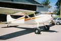
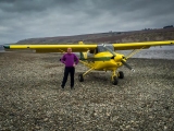
I flew to Klamath Falls and rented a car to drive to the lake. The bikes fit fine in the Maule.
I spent the night in KF prior to heading south in the plane to California for more bicycle riding.
If you have energy left, and I did, I suggest the climb up Mt. Scott. The trailhead is on the rim trail at about 7,000' and it climbs to the highest point in the park at 9,000'.
tcj wrote:8GCBC wrote:Nice IR/VIS photography. Where can we download that? Thank you!
It is a KMZ file. You need Google earth installed on your computer. Save the file then click on it and it will open in google earth. it's seems to be some kind of magic.
http://ftp.nifc.gov/incident_specific_d ... eek_IR.kmz
wannabe wrote:If I can get it here - this link should be "master" incident fire locator with updates.
http://inciweb.nwcg.gov/


Users browsing this forum: No registered users and 0 guests