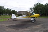
Okay,
We went back to the Rogue and into Agness last Sat. to hike the lower Rogue trail.
A few notes:
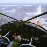
Calm and cool day but still some pretty good sink over where the Illinois River joins the Rogue river.
Power Lines without Marker Balls over (yes over) the Agness Bridge. They are very hard to see and gain elevation as they travel west over the river/bridge. West is to your left as you are on Final.
If you give yourself room over the powerlines, it feels like you are high for landing. This does not seem to be a problem as the strip is up hill (rolling).
So, Give yourself lots of room over the power lines as this is where the "Sink" is as well.
This Airstrip is deceptive from circling above. It looks fairly flat and basic.....
Respect this airstrip.
Agness Approach/Departure Video
Tue Feb 10, 2009 10:46 pm
Agness Approach/Departure Video
Last edited by highroad on Wed Feb 11, 2009 8:40 pm, edited 1 time in total.
- highroad offline

- Posts: 778
- Joined: Wed Feb 20, 2008 10:28 am
- Location: Southern Oregon Coast
- FindMeSpot URL: http://share.findmespot.com/shared/face ... SBWeUVDhQd
- Aircraft: A Maule we call X-ray
Wed Feb 11, 2009 9:44 am
Good info on the strip Brent...Also beware of multiple deer at any time....wind socks located at road in the middle of the strip and also one down at the River end.
River Flyer
River Flyer
- River Flyer offline
- Posts: 2
- Joined: Tue Feb 10, 2009 2:27 pm
- Location: Scenic Rogue River
Wed Feb 11, 2009 10:45 am
Brent
I have heard of a guy doing an approach UNDER the bridge and giving a boost of power to CLIMB up to the runway....
I don't think that I would recommend that approach........
Brian
I have heard of a guy doing an approach UNDER the bridge and giving a boost of power to CLIMB up to the runway....
I don't think that I would recommend that approach........
Brian
- Brian-StevesAircraft offline

- Posts: 759
- Joined: Tue Dec 13, 2005 1:13 pm
- Location: Beagle (White City) Oregon
Wed Feb 11, 2009 12:19 pm
Brian - Steve's Aircraft wrote:I don't think that I would recommend that approach........
Your dad told me a story the day I was over at your shop, about this guy with a Cub who flew into Agness to fish. He didn't have a parking brake, and while he was down at the river he heard a crashing sound and ran up to find his plane had gone off into the trees backwards.
- Zzz offline


- Posts: 2855
- Joined: Fri Oct 08, 2004 11:09 pm
- Location: northern
- Aircraft: Swiveling desk chair
Half a century spent proving “it is better to be thought a fool than to open your mouth and remove all doubt.”
Wed Feb 11, 2009 1:18 pm
Oregon180 wrote:Hey Brent,
Thanks for all the good info on the Agness strip. I was actually over there that same day farting around (didn't see your post until I got back.)
The air felt a little wonky to me that day, so I didn't land, but I did get a good view of the bridge!
I am no expert on Rogue river flying but one thing that I have noticed the last several times I have flown there: If it is Windy on the Coast, the river canyon can be bumpy/turbulent. Several weeks ago it was blowing from the north about 10-15mph over the beach and was turbulent from the mouth to about halfway to Agness. Last Sat. it was blowing harder on the coast and Turbulent to just a few bends down river from Agness. The Agness area was fairly smooth when I went in about 3pm. We came from up river when arriving and the air was still. When I took off about 5pm I thought I would head home up the coastal route. We departed and headed down river and ran into very rough air. We climbed and turned around heading up river to gain altitude and it smoothed out.
Anyway, no rocket science here.....just my observations.
Brent
- highroad offline
- Posts: 778
- Joined: Wed Feb 20, 2008 10:28 am
- Location: Southern Oregon Coast
- FindMeSpot URL: http://share.findmespot.com/shared/face ... SBWeUVDhQd
- Aircraft: A Maule we call X-ray
Wed Feb 11, 2009 8:48 pm
River Flyer,
I was looking at the field w/ the sock in it on the illinois as we were approaching Agness. My dad said that he had heard that the guy that owns that property approaches under the bridge. Is this true? I did not see an obvious mowed area or "strip"
I am not looking to land there, just curious.
Brent
- highroad offline
- Posts: 778
- Joined: Wed Feb 20, 2008 10:28 am
- Location: Southern Oregon Coast
- FindMeSpot URL: http://share.findmespot.com/shared/face ... SBWeUVDhQd
- Aircraft: A Maule we call X-ray
Wed Feb 11, 2009 9:44 pm
Hey Brent ...He use to land flying up the Rogue River under the Lucas lodge water line under the Illinois River Bridge and onto his meadow but he now flies a helicopter and drops right into his place.
River Flyer
River Flyer
- River Flyer offline
- Posts: 2
- Joined: Tue Feb 10, 2009 2:27 pm
- Location: Scenic Rogue River
Wed Feb 11, 2009 11:33 pm
River Flyer wrote:Hey Brent ...He use to land flying up the Rogue River under the Lucas lodge water line under the Illinois River Bridge and onto his meadow but he now flies a helicopter and drops right into his place.
River Flyer
Interesting Approach!
- highroad offline
- Posts: 778
- Joined: Wed Feb 20, 2008 10:28 am
- Location: Southern Oregon Coast
- FindMeSpot URL: http://share.findmespot.com/shared/face ... SBWeUVDhQd
- Aircraft: A Maule we call X-ray
Thu May 26, 2022 10:47 am
Re: Agness Approach/Departure Video
Was just telling a friend about this strip and dredged up this thread. I miss these kind of posts.
- Zzz offline
- Posts: 2855
- Joined: Fri Oct 08, 2004 11:09 pm
- Location: northern
- Aircraft: Swiveling desk chair
Half a century spent proving “it is better to be thought a fool than to open your mouth and remove all doubt.”
Thu May 26, 2022 8:25 pm
Re: Agness Approach/Departure Video
Is this the strip where the Lucas Lodge is located ? And do you need permission to land there ?
Cool Video . Definitely go under the bridge and power lines
Josh
Cool Video . Definitely go under the bridge and power lines
Josh
- Dog is my Copilot offline
- Posts: 433
- Joined: Thu Apr 12, 2018 11:38 am
- Location: Portland
- Aircraft: 1958 Cessna 180A
Thu May 26, 2022 9:14 pm
Re: Agness Approach/Departure Video
Dog is my Copilot wrote:Is this the strip where the Lucas Lodge is located ? And do you need permission to land there ?
Cool Video . Definitely go under the bridge and power lines
Josh
Yes. They appreciate it if you call Lucas Lodge prior to arrival.
- Scolopax offline

- Posts: 1696
- Joined: Tue Sep 27, 2005 5:02 pm
- Location: Nottingham
- FindMeSpot URL: http://share.findmespot.com/shared/face ... 4aYqSexnZC
Thu May 26, 2022 10:58 pm
Re: Agness Approach/Departure Video
Is the lodge an overnight only place or can I fly there and get a $300 hamburger? It looks like a special place.

Fri May 27, 2022 9:19 am
Re: Agness Approach/Departure Video
akschu wrote:Is the lodge an overnight only place or can I fly there and get a $300 hamburger? It looks like a special place.
They used to serve breakfast to the fly in crowd. I am uncertain about what they currently offer.
I was there briefly in February, and they asked that we call first, so my best recommendation is to ring them up. They have been very welcoming in the past.
And, yes it is a very nice spot.
- Scolopax offline
- Posts: 1696
- Joined: Tue Sep 27, 2005 5:02 pm
- Location: Nottingham
- FindMeSpot URL: http://share.findmespot.com/shared/face ... 4aYqSexnZC
Thu Jul 20, 2023 6:56 am
Re: Agness Approach/Departure Video
The Flat Fire started Saturday near the Oak Flat campground on the Illinois River 3 miles south of Agness. Northeast winds so far have limited spread north toward Agness. This morning the IR flight shows 15,217 acres.
Link to the story on Wildfire Today https://wildfiretoday.com/2023/07/18/or ... takes-off/
Link to Incaweb https://inciweb.nwcg.gov/incident-infor ... -flat-fire
Copy and paste these coordinates in the search box in Google Earth or Google maps. 42 30 57, -124 02 14 They will put you at Oak Flats on the Illonois River Three miles south of Agness. You can zoom around and look at the Area. 42 30 57, -124 02 14
The previous fire scars are mostly the Biscuit Fire in 2002.
Looking north

Lucas Lodge Airstrip

Looking west. 13 miles to the pacific ocean at the mouth of the Rogue River

Link to the story on Wildfire Today https://wildfiretoday.com/2023/07/18/or ... takes-off/
Link to Incaweb https://inciweb.nwcg.gov/incident-infor ... -flat-fire
Copy and paste these coordinates in the search box in Google Earth or Google maps. 42 30 57, -124 02 14 They will put you at Oak Flats on the Illonois River Three miles south of Agness. You can zoom around and look at the Area. 42 30 57, -124 02 14
The previous fire scars are mostly the Biscuit Fire in 2002.
Looking north
Lucas Lodge Airstrip
Looking west. 13 miles to the pacific ocean at the mouth of the Rogue River

tcj
Thu Jul 20, 2023 9:15 am
Re: Agness Approach/Departure Video
Really bummed about this fire. Glad to see that Agness and the surrounding structures appear to be ok at this point!
Our mountain bike club as been working pretty hard on opening up the existing trails in the area that the fire is burning. It looks like those trails will be gone at this point, unfortunately.
Of course human life and structures are way more important than trails and trees, but it is sad to see prime recreation area burning up
- highroad offline
- Posts: 778
- Joined: Wed Feb 20, 2008 10:28 am
- Location: Southern Oregon Coast
- FindMeSpot URL: http://share.findmespot.com/shared/face ... SBWeUVDhQd
- Aircraft: A Maule we call X-ray
Fri Jul 21, 2023 8:05 am
Re: Agness Approach/Departure Video
There was no IR flight last night do to cloud cover over the fire. That's a good thing. Here's links to Remote Weather Automated Stations (RAWS) in the Area. 100% Relative Humidity, 52 degrees F, and light winds in Agness this morning.
Agness https://mesowest.utah.edu/cgi-bin/droma ... 3&time=GMT
Quail Prairie Lookout https://mesowest.utah.edu/cgi-bin/droma ... 3&time=GMT
Yesterday's IR with Lookout Location Pins. Coordinates if you want to zoom in on google earth to see what the area looks like today.
Wild Horse 42 28 15.88, -124 09 35.22 Snow Camp 42 20 37.92, -124 09 55.66 Quail Prairie 42 14 31, -124 02 44.93

Wild Horse Lookout. I took this Photo when I was working on the biscuit fire in Oct 2002 The cab collapsed from heavy snow during the winter of 2007/2008. The Sand Mountain Society Removed the cab the following summer. Only the superstructure remains.

The Historical Snow Camp Lookout burned by the Biscuit Fire 2002. The fire team had wrapped it in foil to protect it. After the fire burned through the Operations Chief flew over it in a helicopter and it was still standing, but they didn't land. The Forest Supervisor Flew up there the next day and it was gone. That often happens with foil wrapped structures. You have to get back in on the ground within 30 minutes after the fire passes and check for and smoldering fire under the foil. The Forest Service rebuilt it in 2004 and uses it as a rental cabin. I took the burn photo but snagged the Rental cabin photo off Rex,s Fire lookout site https://www.firelookout.com/

Snow Camp Rental Cabin

Quail Prairie Lookout. I took these photos when I was working on the Craggie Fire in the Kalmiopsis Wilderness in Sept 2001. The roof was also crushed by heavy snow in the winter 2007/2008.


Agness https://mesowest.utah.edu/cgi-bin/droma ... 3&time=GMT
Quail Prairie Lookout https://mesowest.utah.edu/cgi-bin/droma ... 3&time=GMT
Yesterday's IR with Lookout Location Pins. Coordinates if you want to zoom in on google earth to see what the area looks like today.
Wild Horse 42 28 15.88, -124 09 35.22 Snow Camp 42 20 37.92, -124 09 55.66 Quail Prairie 42 14 31, -124 02 44.93
Wild Horse Lookout. I took this Photo when I was working on the biscuit fire in Oct 2002 The cab collapsed from heavy snow during the winter of 2007/2008. The Sand Mountain Society Removed the cab the following summer. Only the superstructure remains.
The Historical Snow Camp Lookout burned by the Biscuit Fire 2002. The fire team had wrapped it in foil to protect it. After the fire burned through the Operations Chief flew over it in a helicopter and it was still standing, but they didn't land. The Forest Supervisor Flew up there the next day and it was gone. That often happens with foil wrapped structures. You have to get back in on the ground within 30 minutes after the fire passes and check for and smoldering fire under the foil. The Forest Service rebuilt it in 2004 and uses it as a rental cabin. I took the burn photo but snagged the Rental cabin photo off Rex,s Fire lookout site https://www.firelookout.com/
Snow Camp Rental Cabin
Quail Prairie Lookout. I took these photos when I was working on the Craggie Fire in the Kalmiopsis Wilderness in Sept 2001. The roof was also crushed by heavy snow in the winter 2007/2008.
tcj
Sun Jul 23, 2023 6:51 am
Re: Agness Approach/Departure Video
IR taken Yesterday morning , July 22, shortly after midnight. 18,463 acres.

Zoomed out

Zoomed out
tcj
Mon Jul 24, 2023 8:09 am
Re: Agness Approach/Departure Video
This morning's IR shows 22,066 total acres burned. The long narrow line of fire on the west end is burn out. They started at Wild horse lookout a couple days ago and continue to the southwest along Forest Service road 3318 on the top of Wild Horse Ridge as conditions allow.

Zoomed out

The Kalmiopsis Wilderness Map

Wild Horse Ridge and Road 3318 upper left


Zoomed out
The Kalmiopsis Wilderness Map
Wild Horse Ridge and Road 3318 upper left
tcj
Fri Jul 28, 2023 7:28 am
Re: Agness Approach/Departure Video
This mornings IR Flight shows 24,329 Acres. Here's my educated guess on tactics. They have put a "Hook", to hook the fire on the southwest end by burning out along Forest Service Roads.

The burnout started at Wildhorse Lookout on the northwest end of the fire, then progressed south and south west along the 3318 road along Wildhorse Ridge to the junction with road 3680 one mile east of Sugarloaf Mountain. Then southeast on road 3680 to Fairview Mountain. Another burnout is progressing south from Saddle Mountain along the 3680 road. About 10 miles total has ben completed There is about 4 or 5 more miles to burnout along road 3680 to enclose the hook.

The burnout started at Wildhorse Lookout on the northwest end of the fire, then progressed south and south west along the 3318 road along Wildhorse Ridge to the junction with road 3680 one mile east of Sugarloaf Mountain. Then southeast on road 3680 to Fairview Mountain. Another burnout is progressing south from Saddle Mountain along the 3680 road. About 10 miles total has ben completed There is about 4 or 5 more miles to burnout along road 3680 to enclose the hook.
tcj
DISPLAY OPTIONS
Who is online
Users browsing this forum: No registered users and 1 guest
Latest Features
-
Live to Tell
A Minnesota pilot is surprised to learn that the sudden asymmetric drag of an out-of-rig ski can…Read More -
Creators
Working in some of the Yukon's most beautiful and remote environments, photographer Simon Blakesley captures aircraft in…Read More -
Aircraft Ownership and Maintenance
Upgrading to big tires can make a huge difference in backcountry performance, but with those gains come…Read More -
Tales from Yesteryear
In this tale from bush flying yesteryear, Don Cogger signs up to help Atlee Dodge Jr recovery…Read More


Latest Knowledge Base
-
Destinations
A regional guide with ideas for winter camping destinations in California, Nevada, New Mexico, and Arizona.Read More -
Aircraft
Finding an affordable aircraft that can handle the backcountry for $80K or less? A challenge for sure, but with the…Read More -
Aircraft
01.29.2018 - Zane - Updated tire diameter graphic to add 8.50x10 Guide to tires for use in the backcountry and off-airport landing…Read More -
Pilots
12.22.2013 - Initial article format Operating aircraft on skis and negotiating a snow-covered landscape is an entirely unique skillset and environment.…Read More


