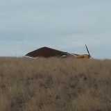
Found this strip when I was flying around the hills north of San Luis Resevoir. Anyone know anything about this strip? I was tempted to land there but since I have little wheels and don't know the condition of the strip and am basically a chicken pilot I was hoping someone with bigger tires and balls would go in and check it out and report back on the field conditions. I guess the road right next to it is landable too. Looks to be about 1500 feet strip. Here's the map with the coords.
[googlemap]https://www.google.com/maps?q=37.2280,+-121.3715&hl=en&ll=37.228005,-121.371503&spn=0.016197,0.030556&sll=37.22698,-121.36837&sspn=0.016197,0.030556&t=h&z=15[/googlemap]
Attention NORCAL pilots - Anyone familiar with this strip?
Fri Dec 13, 2013 4:33 pm
Fri Dec 13, 2013 7:56 pm
Re: Attention NORCAL pilots - Anyone familiar with this stri
That's the Paradise Flat airstrip. I think I know someone who landed there once  It sits in Henry W. Coe State Park. I believe it was shut down in the early 1980's. There's one other strip in the park that is also unfortunately closed.

Fri Dec 13, 2013 8:32 pm
Re: Attention NORCAL pilots - Anyone familiar with this stri
I found this strip several years ago trolling around on GE in the same area. Alway's wondered what was going on up there. Must be private. Usually if it is a park or public area there will be a few of those blue cubes denoting posted photos, but there is nothing there.
Sorry, after 5 minutes of attempting to edit this to show up on the post .I gave up. It's frustrating repeatedly editing url strings and getting no results.
https://maps.google.ca/maps/myplaces?ll=37.323852,-121.539259&spn=0.00703,0.009645&ctz=480&t=h&z=17
Sorry, after 5 minutes of attempting to edit this to show up on the post .I gave up. It's frustrating repeatedly editing url strings and getting no results.
https://maps.google.ca/maps/myplaces?ll=37.323852,-121.539259&spn=0.00703,0.009645&ctz=480&t=h&z=17
- Sidewinder offline
- Posts: 340
- Joined: Mon Sep 30, 2013 5:07 pm
- Location: SouthWest Kanada eh?
Fri Dec 13, 2013 9:58 pm
Re: Attention NORCAL pilots - Anyone familiar with this stri
S Vanarts
Used to fly all over that area until it was turned into a WILDERNESS.
I believe your red marker is actually an old dirt road. Could be wrong. Have not been there in over a year.
BUT - Go from you red marker left to the green arrow then diagonally up and left to that small pond. Enlarge the detail and there IS an old strip just above the right side of the dam. One way in - one way out - windy in the afternoon.
Paradise Flat is a few miles east of this strip.
EDIT The other map that is posted is of a private strip further north on the back side of Mt Hamilton. END OF EDIT
Friend of mine used to take Cessna 310 into Paradise. Before it was all converted to wilderness - we would land - taxi back - and get out just ahead of a guy with a jeep with a shotgun. Used to claim it was his but the 310 pilot said he just did that for the real owner. If any of you ever find it and go for it - there is an almost invisible pipe that stood up about 15-20 feet tall real close on the right.
There are several others back there but are all private. I used to get permission to go into one of them on the south side of a large valley.
One interesting on was a mine where you had to turn uphill rather soon after getting on the ground.
We used to land at several "straight" dirt roads - but did not stay long.
There are some old mine head works back there for those that like to get in low.
PS: We did it all on teeny tired Cubs and Champs. Most pilots out of the old Amelia Reid school were regulars back there. Good fishing at some.
It is nice to know where they are - JUST IN CASE.
Might be able to show ya around if I am feeling OK.
Chris C
Used to fly all over that area until it was turned into a WILDERNESS.
I believe your red marker is actually an old dirt road. Could be wrong. Have not been there in over a year.
BUT - Go from you red marker left to the green arrow then diagonally up and left to that small pond. Enlarge the detail and there IS an old strip just above the right side of the dam. One way in - one way out - windy in the afternoon.
Paradise Flat is a few miles east of this strip.
EDIT
Friend of mine used to take Cessna 310 into Paradise. Before it was all converted to wilderness - we would land - taxi back - and get out just ahead of a guy with a jeep with a shotgun. Used to claim it was his but the 310 pilot said he just did that for the real owner. If any of you ever find it and go for it - there is an almost invisible pipe that stood up about 15-20 feet tall real close on the right.
There are several others back there but are all private. I used to get permission to go into one of them on the south side of a large valley.
One interesting on was a mine where you had to turn uphill rather soon after getting on the ground.
We used to land at several "straight" dirt roads - but did not stay long.
There are some old mine head works back there for those that like to get in low.
PS: We did it all on teeny tired Cubs and Champs. Most pilots out of the old Amelia Reid school were regulars back there. Good fishing at some.
It is nice to know where they are - JUST IN CASE.
Might be able to show ya around if I am feeling OK.
Chris C
53 C-170-B+
It is better to be late in this world, than early in the next.
It is better to be late in this world, than early in the next.
Fri Dec 13, 2013 11:47 pm
Attention NORCAL pilots - Anyone familiar with this strip?
Sidewinder wrote:Sorry, after 5 minutes of attempting to edit this to show up on the post .I gave up. It's frustrating repeatedly editing url strings and getting no results.
When in doubt, don't bother embedding. Just link it. I'm removing the google maps feature because it's too hard for most people to use, including me.
- Zzz offline


- Posts: 2855
- Joined: Fri Oct 08, 2004 11:09 pm
- Location: northern
- Aircraft: Swiveling desk chair
Half a century spent proving “it is better to be thought a fool than to open your mouth and remove all doubt.”
Sat Dec 14, 2013 12:03 am
Re: Attention NORCAL pilots - Anyone familiar with this stri
robw56 wrote:That's the Paradise Flat airstrip. I think I know someone who landed there once
It looks like someone may have been landing there. I saw wheel ruts in the grass but figured they could have been motorcycles.
What did this theoretical person think of the strip? Smooth-ish? Did he find any hidden hazards? Theoretically?
Sat Dec 14, 2013 12:04 am
Re: Attention NORCAL pilots - Anyone familiar with this stri
Sidewinder wrote:I found this strip several years ago trolling around on GE in the same area. Alway's wondered what was going on up there. Must be private. Usually if it is a park or public area there will be a few of those blue cubes denoting posted photos, but there is nothing there.
Sorry, after 5 minutes of attempting to edit this to show up on the post .I gave up. It's frustrating repeatedly editing url strings and getting no results.
https://maps.google.ca/maps/myplaces?ll=37.323852,-121.539259&spn=0.00703,0.009645&ctz=480&t=h&z=17
I've seen this one and was told once by a fairly reliable source that 15 years ago or so the guy that lived there welcomed visiting aircraft. I don't have any current intel on that though. Just as likely to be met with a shotgun these days.
Sat Dec 14, 2013 12:08 am
Re: Attention NORCAL pilots - Anyone familiar with this stri
wannabe wrote:S Vanarts
Used to fly all over that area until it was turned into a WILDERNESS.
I believe your red marker is actually an old dirt road. Could be wrong. Have not been there in over a year.
BUT - Go from you red marker left to the green arrow then diagonally up and left to that small pond. Enlarge the detail and there IS an old strip just above the right side of the dam. One way in - one way out - windy in the afternoon.
Paradise Flat is a few miles east of this strip.
EDIT
Friend of mine used to take Cessna 310 into Paradise. Before it was all converted to wilderness - we would land - taxi back - and get out just ahead of a guy with a jeep with a shotgun. Used to claim it was his but the 310 pilot said he just did that for the real owner. If any of you ever find it and go for it - there is an almost invisible pipe that stood up about 15-20 feet tall real close on the right.
There are several others back there but are all private. I used to get permission to go into one of them on the south side of a large valley.
One interesting on was a mine where you had to turn uphill rather soon after getting on the ground.
We used to land at several "straight" dirt roads - but did not stay long.
There are some old mine head works back there for those that like to get in low.
PS: We did it all on teeny tired Cubs and Champs. Most pilots out of the old Amelia Reid school were regulars back there. Good fishing at some.
It is nice to know where they are - JUST IN CASE.
Might be able to show ya around if I am feeling OK.
Chris C
That sounds fun. Let's go touring when you feel up to it.
Sat Dec 14, 2013 12:11 am
Re: Attention NORCAL pilots - Anyone familiar with this stri
Zzz wrote:Sidewinder wrote:Sorry, after 5 minutes of attempting to edit this to show up on the post .I gave up. It's frustrating repeatedly editing url strings and getting no results.
When in doubt, don't bother embedding. Just link it. I'm removing the google maps feature because it's too hard for most people to use, including me.
Actually it worked pretty good for me. Just click the link icon in Google maps, copy the hyperlink, come to BCP, click the google map button and paste in the link. Like this:
[googlemap]https://www.google.com/maps/ms?msid=213732418950957933334.00045631fb4eb5fa0fe98&msa=0&ll=37.991834,-120.574951&spn=2.051976,3.911133[/googlemap]
Sat Dec 14, 2013 1:16 am
Re: Attention NORCAL pilots - Anyone familiar with this stri
You smart. We dumb. uuug .Can you do a youtube tutorial .I can't even fiqure out how to generate one of those arrowey thingies on GM. It's baffling.
This embedding stuff should be simple for with no need for any editing.
This embedding stuff should be simple for with no need for any editing.
- Sidewinder offline
- Posts: 340
- Joined: Mon Sep 30, 2013 5:07 pm
- Location: SouthWest Kanada eh?
Sat Dec 14, 2013 10:10 am
Re: Attention NORCAL pilots - Anyone familiar with this stri
I bet a mooney never landed there! If it did the owner would prob say its in good shape and that although he's never landed it he'd go again! 

- piperpainter offline
- Posts: 968
- Joined: Sat Nov 29, 2008 10:57 pm
- Location: Auburn, WA
- Aircraft: C-205
Was Backcountry Mooney M20C
Sat Dec 14, 2013 6:16 pm

Sun Dec 15, 2013 11:21 pm
Re: Attention NORCAL pilots - Anyone familiar with this stri
Okay, same area, different strip. What's the story on this strip. I can see it's closed and well within the state park but... It's awfully tempting.
[googlemap]https://www.google.com/maps/ms?msid=213732418950957933334.00045631fb4eb5fa0fe98&msa=0&ll=37.153767,-121.442935&spn=0.008106,0.015278[/googlemap]
[googlemap]https://www.google.com/maps/ms?msid=213732418950957933334.00045631fb4eb5fa0fe98&msa=0&ll=37.153767,-121.442935&spn=0.008106,0.015278[/googlemap]
Fri Jan 10, 2014 6:48 pm
Re: Attention NORCAL pilots - Anyone familiar with this stri
I can neither confirm nor deny that I will be checking out these two strips tomorrow morning. Does anyone have or not have any condition reports on these strips? Anyone been in there lately... or not? 
Fri Jan 10, 2014 7:04 pm
Re: Attention NORCAL pilots - Anyone familiar with this stri
Hoover has big X's on it but it was an old google image. The other was nice when I didn't land there about a year or so ago!
- piperpainter offline
- Posts: 968
- Joined: Sat Nov 29, 2008 10:57 pm
- Location: Auburn, WA
- Aircraft: C-205
Was Backcountry Mooney M20C
Fri Jan 10, 2014 8:04 pm
Re: Attention NORCAL pilots - Anyone familiar with this stri
Thanks Brian! I'll just pretend I didn't hear that. 
As far as Hoover, I'm more concerned with the trees I saw growing in the strip than the X's. Hopefully some gophers dragged the X's away.
As far as Hoover, I'm more concerned with the trees I saw growing in the strip than the X's. Hopefully some gophers dragged the X's away.
Sat Jan 11, 2014 1:08 pm
Re: Attention NORCAL pilots - Anyone familiar with this stri
Too foggy on my side of the valley today. Some other time.
DISPLAY OPTIONS
Who is online
Users browsing this forum: No registered users and 0 guests
Latest Features
-
Live to Tell
A Minnesota pilot is surprised to learn that the sudden asymmetric drag of an out-of-rig ski can…Read More -
Creators
Working in some of the Yukon's most beautiful and remote environments, photographer Simon Blakesley captures aircraft in…Read More -
Aircraft Ownership and Maintenance
Upgrading to big tires can make a huge difference in backcountry performance, but with those gains come…Read More -
Tales from Yesteryear
In this tale from bush flying yesteryear, Don Cogger signs up to help Atlee Dodge Jr recovery…Read More


Latest Knowledge Base
-
Destinations
A regional guide with ideas for winter camping destinations in California, Nevada, New Mexico, and Arizona.Read More -
Aircraft
Finding an affordable aircraft that can handle the backcountry for $80K or less? A challenge for sure, but with the…Read More -
Aircraft
01.29.2018 - Zane - Updated tire diameter graphic to add 8.50x10 Guide to tires for use in the backcountry and off-airport landing…Read More -
Pilots
12.22.2013 - Initial article format Operating aircraft on skis and negotiating a snow-covered landscape is an entirely unique skillset and environment.…Read More


