Backcountry Trail Running Out West
Fri Apr 18, 2025 11:33 am
Backcountry Trail Running Out West
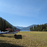
Hey all. When I'm not thinking about airplanes, I'm usually running trails. Anything from smooth, curated singletrack to old Forest Service Roads, to goat paths up 14,000 foot peaks. I've been trying to combine these hobbies here and there. Sometimes I'll fly recon on a far off area to see if the place is melted out yet. Other times I'll fly to destination airports (Steamboat, Angel Fire, etc) and run some good trails in the area. I've been looking for more backcountry-ish places to fly into and do this. Unfortunately, Colorado's list of strips is short. I've been perusing Utah as well, but most places out there seem more geared toward canyoneering and spending time in local rivers. Am I missing something? There's got to be a place a guy can land, tie down, and go run up a hill to a pretty view. Then run back down and camp/fly home of course. Any places come to mind?

Fri Apr 18, 2025 11:54 am
Re: Backcountry Trail Running Out West
If you're up for some travel, a few out in my neck of the woods come to mind.
Sullivan Lake(09S) - lakeshore trail on the east side of the lake, go for a swim after your run and camp as needed.
Priest Lake(67S) - there's a FS road loop from one end of the airstrip to the other up the hill there, spectacular area. I think you can camp there, but I'd probably hike, then fly over to Cavanaugh bay myself.
Stehekin(6S9) - its on the PCT. If you head south of the strip towards the lakeshore trail you can stop by the bakery on your way back. Camp at nearby Harlequin campground.
Ranger Creek(21W) - there's a trail system adjacent to the field. Might see more mountain bikes than runners but would likely suit. Camping at field.
Dug Bar(OR8) - Trail runs N-S along Hells Canyon. Some great views along the way. Camp at the strip9bring firewood).
Meadow Creek(0S1) - great trail at the strip, runs along the river gorge. mostly horseback riding but could be a good run. Camp at the strip.
Some of the strips in the Frank Church have some nice trails adjacent, though some aren't very well traveled so running may be inadvisable to impossible.
- DreadPirateWill offline

- Posts: 101
- Joined: Wed Dec 06, 2017 10:40 am
- Location: Spokane
Fri Apr 18, 2025 12:59 pm
Re: Backcountry Trail Running Out West
You are right, nothing in Utah, or Colorado, nothing at all.
- StillLearning offline
- Posts: 417
- Joined: Mon Nov 05, 2018 6:22 pm
- Location: Salmon
- Aircraft: Cessna 180 Skywagon 1953
Fri Apr 18, 2025 1:34 pm
Re: Backcountry Trail Running Out West
StillLearning wrote:You are right, nothing in Utah, or Colorado, nothing at all.
If only there was a place to ask for beta on such an intersection in adventure interests...like maybe a website with active people who like to fly to backcountry airstrips. I recommend asking the question there where the kind and helpful folks will steer you in the right direction without snark.
- Zzz offline


- Posts: 2854
- Joined: Fri Oct 08, 2004 11:09 pm
- Location: northern
- Aircraft: Swiveling desk chair
Half a century spent proving “it is better to be thought a fool than to open your mouth and remove all doubt.”
Fri Apr 18, 2025 1:53 pm
Re: Backcountry Trail Running Out West
Sorry for the dick response, but to say that Utah is only about canyoneering or river access is ridiculous, almost like an AI generated response to “what is there to do in Utah”
OP posted a trip report a while back about going to every airport in Colorado, apparently none of those have hiking or climbing. Or maybe they do?
In Colorado, perhaps KGWS, Marble, Dolores Point, Aspen, Gunnison, or many others. If municipal airports are out, then yes, there are not a plethora of options, but there are options.
Utah has dozens of airstrips, most of which are in spectacular country, all with hiking, many with climbing, several with water access. I don’t know how you could discount Utah for the stated desires, unless the desire is only to summit named mountains. Or just go land on a dirt road near some cool shit.
- StillLearning offline
- Posts: 417
- Joined: Mon Nov 05, 2018 6:22 pm
- Location: Salmon
- Aircraft: Cessna 180 Skywagon 1953
Fri Apr 18, 2025 3:14 pm
Re: Backcountry Trail Running Out West
DreadPirateWill wrote:If you're up for some travel, a few out in my neck of the woods come to mind.
Sullivan Lake(09S) - lakeshore trail on the east side of the lake, go for a swim after your run and camp as needed.
Priest Lake(67S) - there's a FS road loop from one end of the airstrip to the other up the hill there, spectacular area. I think you can camp there, but I'd probably hike, then fly over to Cavanaugh bay myself.
Stehekin(6S9) - its on the PCT. If you head south of the strip towards the lakeshore trail you can stop by the bakery on your way back. Camp at nearby Harlequin campground.
Ranger Creek(21W) - there's a trail system adjacent to the field. Might see more mountain bikes than runners but would likely suit. Camping at field.
Dug Bar(OR8) - Trail runs N-S along Hells Canyon. Some great views along the way. Camp at the strip9bring firewood).
Meadow Creek(0S1) - great trail at the strip, runs along the river gorge. mostly horseback riding but could be a good run. Camp at the strip.
Some of the strips in the Frank Church have some nice trails adjacent, though some aren't very well traveled so running may be inadvisable to impossible.
Now that's a list! Thanks a bunch, I'll be doing some research for the next time I get to go NW from home.
Fri Apr 18, 2025 3:17 pm
Re: Backcountry Trail Running Out West
Zzz wrote:StillLearning wrote:You are right, nothing in Utah, or Colorado, nothing at all.
If only there was a place to ask for beta on such an intersection in adventure interests...like maybe a website with active people who like to fly to backcountry airstrips. I recommend asking the question there where the kind and helpful folks will steer you in the right direction without snark.
What he said. My interests can be fairly niche--running and hiking to high places. But this is the best place I've found for asking backcountry-related questions.
Fri Apr 18, 2025 3:26 pm
Re: Backcountry Trail Running Out West
StillLearning wrote:Sorry for the dick response, but to say that Utah is only about canyoneering or river access is ridiculous, almost like an AI generated response to “what is there to do in Utah”
OP posted a trip report a while back about going to every airport in Colorado, apparently none of those have hiking or climbing. Or maybe they do?
In Colorado, perhaps KGWS, Marble, Dolores Point, Aspen, Gunnison, or many others. If municipal airports are out, then yes, there are not a plethora of options, but there are options.
Utah has dozens of airstrips, most of which are in spectacular country, all with hiking, many with climbing, several with water access. I don’t know how you could discount Utah for the stated desires, unless the desire is only to summit named mountains. Or just go land on a dirt road near some cool shit.
Nah, I get it. But like you said, the problem is that all of those are airports, not backcountry strips or landing zones. I've been to each of the places you named minus Dolores Point (on my list!) and found great hiking/running/biking. I've been eyeing a great loop south of Marble for months now, waiting for the snow to thaw.
My experience with Utah has been mostly four wheeling in Moab and short overnights in Salt Lake, so I'm still looking for where the cool, yet off the beaten path outdoor fun is. Especially on the West side of the state. Fremont Island looks cool, and perhaps Steer Ridge? There's also the CO/UT border strips to consider. But there's only so much to be gleaned from the UT BCPA site and topo maps.
Fri Apr 18, 2025 3:46 pm
Re: Backcountry Trail Running Out West
If you have been to the UBCP site, then you know there are potentially hundreds of airstrips in Utah. You said west side, but I wonder if that is a mistake, there isn't much on the west side of Utah. If trail running is your thing, not sure what is wrong with all the airstrips in eastern / northern Utah. Which again, is why I don't understand the dismissal of Utah. You have spent the $30 on the UBCP content pack right? Utah is the best flying outside of Idaho, and even then Utah has some really great places, most of which are landable all year long. As opposed to Idaho that doesn't offer much past about November 1 or before May 1.
In Colorado, if airPORTS are of no interest, there is Marble, Dolores Point, Gateway, Steamboat Mesa (barely Utah), Calamity, Flattop, Carpenterridge, BullCanyon. But then you already saw those on the content pack.
In Utah there are too many to list. If you are looking for a tour book there is even a Galen Hanselman book for Utah.
But, the downside to Utah will be here in about a month.
- StillLearning offline
- Posts: 417
- Joined: Mon Nov 05, 2018 6:22 pm
- Location: Salmon
- Aircraft: Cessna 180 Skywagon 1953
Sat Apr 19, 2025 4:54 pm
Re: Backcountry Trail Running Out West
StillLearning wrote:If you have been to the UBCP site, then you know there are potentially hundreds of airstrips in Utah. You said west side, but I wonder if that is a mistake, there isn't much on the west side of Utah. If trail running is your thing, not sure what is wrong with all the airstrips in eastern / northern Utah. Which again, is why I don't understand the dismissal of Utah. You have spent the $30 on the UBCP content pack right? Utah is the best flying outside of Idaho, and even then Utah has some really great places, most of which are landable all year long. As opposed to Idaho that doesn't offer much past about November 1 or before May 1.
In Colorado, if airPORTS are of no interest, there is Marble, Dolores Point, Gateway, Steamboat Mesa (barely Utah), Calamity, Flattop, Carpenterridge, BullCanyon. But then you already saw those on the content pack.
In Utah there are too many to list. If you are looking for a tour book there is even a Galen Hanselman book for Utah.
But, the downside to Utah will be here in about a month.
I think perhaps I'm not explaining what I'm looking for well enough. Utah has no shortage of fun strips for camping, fishing, and just landing at overall. Like you said, there's all sorts of fun flying to be done. But what strips among them have good trail running?
Take Dolores Point. Sure, I'm looking forward to visiting it and camping, but aside from going out and back on the runway and nearby roads, I wouldn't call it a great trail running spot. When I look around the UBCP map and check strips, most of them seem to be this way. You've mentioned a good amount of airports here in Colorado, and I've looked into quite a few before posting. But most of them seem to be the same way. I could run in circles on top of many of the very cool, scenic mesas, sure. But that's not the goal.
Sun Apr 20, 2025 6:42 am
Re: All the Airports in Colorado
Tieton State 4S6, Know as Rimrock Airstrip by the locals. About 40 miles west of Yakima, WA on Highway 12, White Pass. You can camp deside your plane.

The Russel Ranch now on the bottom of Rimrock Lake. When I was a kid, 65 years ago. the rock fireplace was still standing and the fence posts for the cow pasture were still there.

Recreation Guide published by the Forest Service in 1936.

Approach to landing to the east. Goose Egg Mountain on the left. There is a trail to the top. You can walk to it from the Airstrip. It is a good work out.

Another shot of Goose Egg from my little fishing Boat.

Klootchman, it means Woman in Chinook Jargon. My Grandpa said it is a pregnant Indian woman laying on her back, her head on the left and her big belly on the right. Get a copy of "Of Men and Mountains" by former Sepreme Court Justice William O. Douglas. Read the last chapter "Klootchman" before you go. He and a friend climbed it. I took the book with me and used it to find the route they took. I didn't make it. You have to jump up in one spot. I was chicken to do that.

Mount Rainier on the skyline right, the Goat Rocks Wilderness on the left. Klootchman on the left side of the lake, Goose Egg on the right. Photo taken from Jump Off Fire Lookout.

The Russel Ranch now on the bottom of Rimrock Lake. When I was a kid, 65 years ago. the rock fireplace was still standing and the fence posts for the cow pasture were still there.
Recreation Guide published by the Forest Service in 1936.
Approach to landing to the east. Goose Egg Mountain on the left. There is a trail to the top. You can walk to it from the Airstrip. It is a good work out.
Another shot of Goose Egg from my little fishing Boat.
Klootchman, it means Woman in Chinook Jargon. My Grandpa said it is a pregnant Indian woman laying on her back, her head on the left and her big belly on the right. Get a copy of "Of Men and Mountains" by former Sepreme Court Justice William O. Douglas. Read the last chapter "Klootchman" before you go. He and a friend climbed it. I took the book with me and used it to find the route they took. I didn't make it. You have to jump up in one spot. I was chicken to do that.
Mount Rainier on the skyline right, the Goat Rocks Wilderness on the left. Klootchman on the left side of the lake, Goose Egg on the right. Photo taken from Jump Off Fire Lookout.
Last edited by tcj on Sun Apr 20, 2025 8:45 am, edited 1 time in total.

tcj
Mon Apr 21, 2025 7:03 am
Re: Backcountry Trail Running Out West
0U2, the Copper Basin airstrip in Idaho. Great scenery in the basin, even better if you run up to the top of the Burma Road to the east and eyeball the Lemhi Range. Lots of old mine sites on the slopes surrounding the basin, some spooky as hell!
- courierguy offline

- Posts: 4197
- Joined: Thu Mar 31, 2005 6:52 pm
- Location: Idaho
"Its easier to apologize then ask permission"
Tex McClatchy
Tex McClatchy
Sat Apr 26, 2025 11:42 am
Re: Backcountry Trail Running Out West
We should prolly meet up seeing as we have similar interests, airplanes, and are based at the same airport. We could get more done with a ferry rather than limiting to loops. 
If you need a trail to run, you're gonna be hard pressed to find a lot of that RIGHT next to strips - the pilots tend to not be the most athletic. That being said, some adventurous souls can bushwack a bit and get to some awesome stuff.
Marble is next to amazing running up to Schofield pass - and huge amounts of single track to take you down into Crested Butte. Telluride - same - including adding in via ferrata jsut south of town. From the airport there is a trailhead across the street to Last Dollar and if you are fit enough probably and adventurous run up Sneffles.
Del Norte, Morning Shadows, La Garita (no longer access) has access north to penitente. To the east, you have Hooper hot springs - again depending on the time of year you could run out to the Great Sand Dunes NP.
To the west there is Pagosa Springs. There's a small park right next to the airport. A little further run downtown to top out at Reservoir park and a few lollipop loops and then back down to the hippy dips before back to the airport.
Many options in Leadville just east, north and west of town up into the Mosquito range.
Mack Mesa is right next to Highlight State park with a quick loop around the lake. Not far is the book cliffs and all the stuff around fruita if you are into longer distance. Across the road is access to the Rabbit Valley and Kokopelli trails and you can run all the way to Moab if you desire. I chose the two wheel mountain bike adventure and ferried my 180 to the other side for the flight home.
Speaking of Utah - depending on the time of the year there is tons of backcountry access next to hundreds of strips. Combine the location of the strip with OnX Backcountry with offline maps to help to find solutions. Too much really to write about.
To the north of us in Wyoming there is Custer County (RIP Custer State Park) with access to the black hills. Even closer is Glendo with nice loops out at the state park right next tot he strip with awesome camping under the cottonwoods right at the strip. There's the Miracle mile with access to the North Platte river though I think you'll be running on dirt roads if that's okay.
- soyAnarchisto offline

- Posts: 1975
- Joined: Fri Aug 19, 2011 1:23 pm
- Location: Boulder, CO
- Aircraft: 1955 Cessna 180
Sun Apr 27, 2025 9:59 am
Re: Backcountry Trail Running Out West
Whenever I hear someone talk about running as a hobby I always thing back to this

To add some value other than humor, lots of the backcountry spots I’ve gone are probably more suited for hiking, shy of running up and down the strip, copalis beach might be good though
To add some value other than humor, lots of the backcountry spots I’ve gone are probably more suited for hiking, shy of running up and down the strip, copalis beach might be good though
- NineThreeKilo offline
- Retired
- Posts: 1679
- Joined: Thu Dec 31, 2009 8:16 pm
- Location: _
Sun Apr 27, 2025 4:57 pm
Re: Backcountry Trail Running Out West
tcj wrote:Tieton State 4S6, Know as Rimrock Airstrip by the locals. About 40 miles west of Yakima, WA on Highway 12, White Pass. You can camp deside your plane.
The Russel Ranch now on the bottom of Rimrock Lake. When I was a kid, 65 years ago. the rock fireplace was still standing and the fence posts for the cow pasture were still there.
Recreation Guide published by the Forest Service in 1936.
Approach to landing to the east. Goose Egg Mountain on the left. There is a trail to the top. You can walk to it from the Airstrip. It is a good work out.
Another shot of Goose Egg from my little fishing Boat.
Klootchman, it means Woman in Chinook Jargon. My Grandpa said it is a pregnant Indian woman laying on her back, her head on the left and her big belly on the right. Get a copy of "Of Men and Mountains" by former Sepreme Court Justice William O. Douglas. Read the last chapter "Klootchman" before you go. He and a friend climbed it. I took the book with me and used it to find the route they took. I didn't make it. You have to jump up in one spot. I was chicken to do that.
Mount Rainier on the skyline right, the Goat Rocks Wilderness on the left. Klootchman on the left side of the lake, Goose Egg on the right. Photo taken from Jump Off Fire Lookout.
You gave me a cool running spot, a good book recommendation, AND pictures?? I'm spoiled! Thank you!
Sun Apr 27, 2025 4:59 pm
Re: Backcountry Trail Running Out West
courierguy wrote:0U2, the Copper Basin airstrip in Idaho. Great scenery in the basin, even better if you run up to the top of the Burma Road to the east and eyeball the Lemhi Range. Lots of old mine sites on the slopes surrounding the basin, some spooky as hell!
Thanks! I'll add this to my (now) growing list for an Idaho trip one day! Washington, Idaho, etc are pretty far away, so I have to put together a good and full trip before I can go out.
Sun Apr 27, 2025 7:08 pm
Re: Backcountry Trail Running Out West
soyAnarchisto wrote:We should prolly meet up seeing as we have similar interests, airplanes, and are based at the same airport. We could get more done with a ferry rather than limiting to loops.
If you need a trail to run, you're gonna be hard pressed to find a lot of that RIGHT next to strips - the pilots tend to not be the most athletic. That being said, some adventurous souls can bushwack a bit and get to some awesome stuff.
Marble is next to amazing running up to Schofield pass - and huge amounts of single track to take you down into Crested Butte. Telluride - same - including adding in via ferrata jsut south of town. From the airport there is a trailhead across the street to Last Dollar and if you are fit enough probably and adventurous run up Sneffles.
Del Norte, Morning Shadows, La Garita (no longer access) has access north to penitente. To the east, you have Hooper hot springs - again depending on the time of year you could run out to the Great Sand Dunes NP.
To the west there is Pagosa Springs. There's a small park right next to the airport. A little further run downtown to top out at Reservoir park and a few lollipop loops and then back down to the hippy dips before back to the airport.
Many options in Leadville just east, north and west of town up into the Mosquito range.
Mack Mesa is right next to Highlight State park with a quick loop around the lake. Not far is the book cliffs and all the stuff around fruita if you are into longer distance. Across the road is access to the Rabbit Valley and Kokopelli trails and you can run all the way to Moab if you desire. I chose the two wheel mountain bike adventure and ferried my 180 to the other side for the flight home.
Speaking of Utah - depending on the time of the year there is tons of backcountry access next to hundreds of strips. Combine the location of the strip with OnX Backcountry with offline maps to help to find solutions. Too much really to write about.
To the north of us in Wyoming there is Custer County (RIP Custer State Park) with access to the black hills. Even closer is Glendo with nice loops out at the state park right next tot he strip with awesome camping under the cottonwoods right at the strip. There's the Miracle mile with access to the North Platte river though I think you'll be running on dirt roads if that's okay.
I like the way you think! Shot you a FR.
Marble is already on my list for sure, as well as Telluride--although the latter requires a ride into town of some kind, plus landing fees. I hadn't given the Alamosa area there much thought, but I'll be considering what you said now. Especially the Dunes! Leadville is another "ride into/out of" kinda place--something that a folding bike might solve, with the right planning. Good WY beta!
Sun Apr 27, 2025 7:12 pm
Re: Backcountry Trail Running Out West
NineThreeKilo wrote:Whenever I hear someone talk about running as a hobby I always thing back to this
To add some value other than humor, lots of the backcountry spots I’ve gone are probably more suited for hiking, shy of running up and down the strip, copalis beach might be good though
Added to the Washington Bucket, thanks! First rule of Zombieland: Cardio! If I ever get forced down someplace and have to walk out, it's comforting to know I have the fitness to move a bit faster.
DISPLAY OPTIONS
Who is online
Users browsing this forum: No registered users and 1 guest
Latest Features
-
Live to Tell
A Minnesota pilot is surprised to learn that the sudden asymmetric drag of an out-of-rig ski can…Read More -
Creators
Working in some of the Yukon's most beautiful and remote environments, photographer Simon Blakesley captures aircraft in…Read More -
Aircraft Ownership and Maintenance
Upgrading to big tires can make a huge difference in backcountry performance, but with those gains come…Read More -
Tales from Yesteryear
In this tale from bush flying yesteryear, Don Cogger signs up to help Atlee Dodge Jr recovery…Read More


Latest Knowledge Base
-
Destinations
A regional guide with ideas for winter camping destinations in California, Nevada, New Mexico, and Arizona.Read More -
Aircraft
Finding an affordable aircraft that can handle the backcountry for $80K or less? A challenge for sure, but with the…Read More -
Aircraft
01.29.2018 - Zane - Updated tire diameter graphic to add 8.50x10 Guide to tires for use in the backcountry and off-airport landing…Read More -
Pilots
12.22.2013 - Initial article format Operating aircraft on skis and negotiating a snow-covered landscape is an entirely unique skillset and environment.…Read More


