Hi Guys.
Curious if anyone owned one of these units as well? Do you like them? Looks like you get a lot for the money.
So far the best price I have found is on pilotshop.com $750.....
Best price for a Lowrance Airmap 2000c
Sun Jan 07, 2007 4:22 pm

Mon Jan 08, 2007 2:11 pm
Chief has em for $729.
My days of buying stuff on ebay rather than reputable retailers are over. These days I swear by REI, Sierra Trading Post, etc. They will take anything back forever. I say forget the $30 and buy from a retailer with a solid history.
My days of buying stuff on ebay rather than reputable retailers are over. These days I swear by REI, Sierra Trading Post, etc. They will take anything back forever. I say forget the $30 and buy from a retailer with a solid history.
- Zzz offline


- Posts: 2854
- Joined: Fri Oct 08, 2004 11:09 pm
- Location: northern
- Aircraft: Swiveling desk chair
Half a century spent proving “it is better to be thought a fool than to open your mouth and remove all doubt.”
Mon Jan 08, 2007 3:53 pm
Zane,
The places I was refering to are known retailers. They also sell their wares on ebay....
But I hear what you are saying about ebay sellars. Buyer be ware!!! There was an 0-320 listed that just happened to be here on a plane in Honolulu airport. I asked the guy if it was airworthy and if it was in running condition. He stated it was.....well I had access to the parking area and went and looked at it. It had blown a cylinder off the studs and he was trying to bolt it back together and sell it as a good engine. I wished I had known how to get ahold of the people bidding on it to notify them. The people down at the airport told me to look out for anything this guy was selling.
Tue Jan 09, 2007 10:45 am
I bought a 2000c for $700 through West Coast Avionics. I have a Garmin 195 also, and honestly the Garmin is a better format. It gives you much better control over the display, allowing you to tweak it just how you want it. That said, spend one day looking at the big color display of the 2000c and you'll never glance at a black and white display again. I have good eye sight, and I cannot believe how difficult it is to use the Garmin after getting used to the color display on the 2000c.
There is a reliability issue, however. My 2000c froze up shortly after I purchased it. Lowrance sent me a new memory card which fixed the problem. Then it started having other problems...freezing up, runaway cursor, display lighting going haywire. I sent it back to Lowrance and they sent me a new unit, which has worked well, though there are still some quirks with the display lighting. I'm nervous enough about the reliability of the unit that I kept my 195 installed as a back-up.
Lowrance has good customer service, but I get the feeling the price on the 2000c dropped because there is some inherent flaw in the hardware design. I know two other people with the 2000c and they haven't had the problems I have, but they don't fly nearly as much as I do either.
Also, I found that the suction cup mount works well as long as it's warm, but when it cools down it will not adhere. Anything below forty degrees and get ready for the gps to fall in your lap.


Thu Jan 18, 2007 2:43 pm
Thanks for the info guys. Sorry I have been without a PC for a while.
JCB how long will the unit run on 4AA batteries? Do you think I would be better off withg an Airmap 600C instead? I just can't swing the Garmin 296. This unit seemed like a really good deal. I wonder if a lot of people are experiencing the freeze ups, etc.... The price almost seems to good to be true...
JCB how long will the unit run on 4AA batteries? Do you think I would be better off withg an Airmap 600C instead? I just can't swing the Garmin 296. This unit seemed like a really good deal. I wonder if a lot of people are experiencing the freeze ups, etc.... The price almost seems to good to be true...

Wed Jan 24, 2007 11:47 am
gps in the backcountry
I sympathize with the desire to keep flying simple and elemental and not to become overly dependent on gadgets. I've seen people nearly wreck because they planned their approach to a backcountry strip based on their GPS and not on their eyeballs and brains. I like keeping my finger on the map, too, and sometimes the map is a USGS topo or a USFS district map instead of a sectional.
That said, a gps with a terrain database (like the Garmin 2, 3 and 496) offers an emergency safety benefit that's hard to beat, IMHO. If you're down in a canyon and get trapped by weather, with no way back to a place to land (in other words, you really screw up), having a gps with terrain could allow you to climb up through the clag until you're on top. Then you can hit the "nearest" button and follow the line to someplace that has an approach, or at least a low valley where there's a ceiling you can descend below.
This may sound fanciful, but a high time veteran air taxi operator died a couple of years ago under these circumstances. He got trapped down low in a tight canyon and tried to escape by making a corkscrew climb. He flew into a mountain at Vx just a couple hundred feet below the top of the peak. If he'd had a gps with terrain, he could have kept away from the rocks.
The same goes at night. Finger on the map doesn't work so well in the dark.
Before gps had terrain, I considered it nice-to-have but not need-to-have. While I wouldn't call gps w/terrain essential equipment, it's definitely a need-to-have in my book. YMMV of course.
CAVU

Sat Jan 27, 2007 8:32 am
One other thing, if you have one you do not need to use it, put it in the flight bag, but if you find that you need it you can always turn it on. If you don't have one well....
I like mine with terrain and my system has an antenna locater on it as well. All antennas that are built over 200 feet must be licensed and others that are shorter than 200 feet are subject to being licensed by both the FCC and the FAA. The license must be determined prior to building the antenna.
You may be surprised by the amount of antennas out there in unpopulated areas. When going out and nap of the earth flying it is nice to know where they are. In the case of my gps this can be up dated daily. One still needs to be very diligent with regards to all things attached to the earth, but there have been plenty of times that it picks up an antenna with in a mile to one side that I did not see.
- soaringhiggy offline
- Posts: 711
- Joined: Tue Dec 13, 2005 8:22 pm
- Location: Kimberly, ID
48 Stinson 108-3
Sat Jan 27, 2007 9:50 am
soaringhiggy wrote:You may be surprised by the amount of antennas out there in unpopulated areas. When going out and nap of the earth flying it is nice to know where they are. In the case of my gps this can be up dated daily. One still needs to be very diligent with regards to all things attached to the earth, but there have been plenty of times that it picks up an antenna with in a mile to one side that I did not see.
Does your database include power lines across canyons and rivers? I have a harder time seeing them than I do the towers.
tom
- Savannah-Tom offline
- Posts: 891
- Joined: Mon Mar 06, 2006 3:26 pm
- Location: Corvallis, OR
Sat Jan 27, 2007 11:57 am
When I got my private pilot license GPS was a military-only thing, and I'm still amazed at how precise pilotage and dead-reckoning are. I don't spend forty minutes plotting a x-country flight anymore because gps makes it all so damn easy. I'm not recommending dependence on gps, but at the same time I think it's silly not to take advantage of gps technology. For a few hundred dollars you get unlimited access to a few hundred billion dollars worth of satellites...I think it's one of the truly great things our government has done for us.
It goes without saying that a gps is no substitute for knowing where you are, but shunning technology today because you didn't have it yesterday makes about as much sense as declining antibiotics when you get your wisdom teeth out... after all, your great-grandfather got his pulled without antibiotics, and he lived for several more weeks.
Aeronautical charts are "newfangled technology" to my grandfather's generation, and the average pilot is much more likely to get into trouble trying to read a chart in the cockpit than pushing buttons on a gps. For years planes flew without a altimeter, so is that just a fancy distraction, too? Shunning a gps is about as smart as shunning a turn coordinator or a VSI or a oil temperature gage because they'll distract you from flying the airplane...division of attention is a basic pilot skill regardless of where or what you fly.
Last summer I was dumb enough to end up in IFR conditions as a VFR pilot. I had already begun my 180 turn back to the airport when the ground disappeared (rapidly lowering ceiling), but I was immediately at full capacity just flying the airplane. By pushing two buttons on my gps I got a nice, fat line directing me back to the airport, which let me give a whole lot more of my concentration to attitude, airspeed and altitude. That made a BIG difference.
The new terrain awareness feature on the 2000c is definitely an improvement over earlier formats. If nothing else, it's just easier on the eyes. Do you need one to fly? Of course not. But when it gives you so much for so little, why the hell wouldn't you? As I recall the guys from "big rocks and long props" use a gps to double-check their ground speed, and you can hardly accuse them of substituting technology for skill.
Oh ya, my new 2000c has worked fine for about three months. I'm very happy with it, though cheaper ones will do almost as much.
Sat Jan 27, 2007 12:24 pm
Since when is money an issue with us, you guys??!! I plan to buy a Garmin handheld this spring, and there is no question about it for me-- I will have one. Like CAVU said: Better to have one and not need it...
I did all my basic flight training without one, and when I started flying an aircraft with a GNS430, I tried to use it only as a backup, to keep my pilotage skills sharp. It's a heck of a lot more work to track your position with pilotage, but for n00bs and low time pilots like myself, it's more rewarding too.
That said, I have to admit that my life is technology, computers and gadgets. I love it all. I enjoy using the GPS on a flight, then coming home and overlaying my track on Google Earth and analysing where I went and how wacky my flying was.
I'd also rather be a talking, breathing lesser pilot who depended on GPS in a low viz situation, than a kickass map and compass guy splattered on the mountainside.
- Zzz offline
- Posts: 2854
- Joined: Fri Oct 08, 2004 11:09 pm
- Location: northern
- Aircraft: Swiveling desk chair
Half a century spent proving “it is better to be thought a fool than to open your mouth and remove all doubt.”
Sun Jan 28, 2007 9:24 am
ravi wrote:It goes without saying that a gps is no substitute for knowing where you are, but shunning technology today because you didn't have it yesterday makes about as much sense as declining antibiotics when you get your wisdom teeth out... after all, your great-grandfather got his pulled without antibiotics, and he lived for several more weeks.
I agree. Some folks think that gps is doing it the "easy way" and then go on about pilotage and vor. I say use what you have to the best advantage to your situation.
Here's my favorite uses for my gps:
Once up at cruise altitude, I use the gps to establish the proper direction of flight given the wind conditions. Then I use that mountain over there, or whatever as a visual guide.
Again, at altitude, I can see on the gps what my estimated time enroute is and compare that to remaining fuel.
Also my plane cruises painfully slow (85mph), so I pay a lot of attention to the winds. The gps report of true ground speed lets me find the best altitude to take advantage of the winds.
I don't have it, but if I did, terrain awareness would be great to know if I'm gonna clear the ridge ahead. I know how to watch the ridge in the windshield to see if I'll clear it, or watch for stuff beyond the ridge to increase, but these take time to see the effect. The gps would let me know instantly.
Sometimes when the fields in the valley are all mowed, it is hard to pick out a grass strip from the rest of farmland. The gps is very useful to get my attention focussed in the right direction.
tom
- Savannah-Tom offline
- Posts: 891
- Joined: Mon Mar 06, 2006 3:26 pm
- Location: Corvallis, OR
Sun Jan 28, 2007 5:16 pm
I personally use my gps when I fly to the big city airport that doesn't have a vor. I don't know about you guys but flying into an unfamilar city with the airport smack dab in the middle of all the roads, lights and pavement can be difficult while trying to maintain visual seperation from the Cirrus (sorry about the jab) that is "on the glass" on his way outta' town.
When I'm headed for the hills, it is nice for an initial heading and distance but from there I'm on the sectional.
Just my .02...
Mark
When I'm headed for the hills, it is nice for an initial heading and distance but from there I'm on the sectional.
Just my .02...
Mark
- retired user offline
- Posts: 710
- Joined: Sat Oct 01, 2005 7:07 am
Sun Jan 28, 2007 10:52 pm
I agree GPS is not necessary, but it is nice and I love tech. I think it just take a while for people to get used to the idea of GPS...like it was sais...sectionals used to be 'new technology'!!
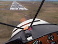
I think I am going to go with the Lowrance airmap 600c instead of the 2000c...looks like from the specs that the battery life is a heck of a lot longer....that and I am deciding I probably don't need that big of a unit...ecspecially if it is sitting on the yoke right in front of me. The 600c also has a terrian DB.
I think I am going to go with the Lowrance airmap 600c instead of the 2000c...looks like from the specs that the battery life is a heck of a lot longer....that and I am deciding I probably don't need that big of a unit...ecspecially if it is sitting on the yoke right in front of me. The 600c also has a terrian DB.
Mon Jan 29, 2007 12:22 am
Tom,
Yes mine does show lines and canyons. it also shows winds aloft at 1000 foot incriminates. It is an amazing machine, and it supplements my dead reckoning very well. the other function that it has is that is shows the fuel prices at all the airports that you could go to. You would be surprised at the differences in fuel cost.
It does so much more that this, it show ground wind at the airport in direction and speed relative to the runway, it shows if the vis is ifr in horizontal or vertical or both aspects for any given airport based on their last advisory etc.
Any one who states that this cannot help them over dead reckoning alone is in my mind crazy.
I do not rely on it for all of my info and I still use my check points and sectional as well, but it is a great safety device.
I loveit.
Dane
- soaringhiggy offline
- Posts: 711
- Joined: Tue Dec 13, 2005 8:22 pm
- Location: Kimberly, ID
48 Stinson 108-3
Mon Jan 29, 2007 12:57 pm
I have to agree about GPS.
When I was just starting out I made my ground GPS into an aviation one by manually inputting all of the MN & WI airports in the AFD into my GPS.
Then I started to fly at night in the winter with lower ceilings so I bought a Garmin 96c with the towers database. It's a great unit and still is my backup. If I was in the mountains I would have gotten the full terrain GPS.
Then I started doing 200-500nm trips and bought a Garmin 396 with the XM weather. I can't stress enough the added value of having live nexrad radar, graphical metars, winds aloft (updated each hour), TAFs, etc. Having weather in the plane has allowed me to make a lot of trips that I wouldn't have by looking just at the FBO weather computer.
People find it funny that being an avionics tech that when I bought my plane I removed the audio panel, 2 nav/comms, ADF, and a loran; all of which didn't work. I then installed a Garmin audio panel, Garmin SL-40 com and the Garmin 396. The transponder still worked. But that is all of my avionics. If the 396 goes out I fallow a sectional which is easy because I never use the direct to button and always use a flight plan in the GPS. So if it goes out I fallow my heading I was on. I already know how far I'm out of my destination (are we there yet?). I take the sectional and draw a line between airports and almost immediately I know where I am. I'm on that line X miles out.
FWIW- The 396 automatically tunes the comm and gives me audible terrain warnings through the audio panel.
Got to run...
Todd Giencke
Mon Jan 29, 2007 12:58 pm
Regarding that wonderful terrain database... I must say that it is endlessly entertaining (I love seeing the radio towers pop up like red mushrooms when I turn towards them), and can be quite informative, as it gives a picture of the terrain around you which can be significantly greater than what you can see from the cockpit. There are some problems users should be aware of, however.
First off, while the data on the topo card is probably very accurate, anyone who has studied maps (of any manufacture) soon realizes they are full of small (and sometimes not so small) flaws. The gps database is no different, and some of those flaws relate to the altitude of a given piece of mountain/tower/structure. Of course, the gps database does not include such things as a grove of 300-foot trees growing on a 2000 foot ridge... it just shows a 2000 foot ridge.
More importantly, gps receivers, even with WAAS, do a much better job of pinpointing locations in a horizontal plane than they do in a vertical plane. So while your position might be accurate to within half a wingspan in the horizontal plane, the margin for error is much higher in relation to your altitude. Since they juxtapose the altitude your gps believes its at to the altitude the database says is around you to show your terrain clearance, both of these errors result in an potentially inacccurate depiction of the terrain around you. While sitting on a runway I'll routinely see a 100 foot difference between the altitude my gps states Iamb at, and the altitude the terrain database tells me my wheels are parked on.
In my experience there is usually a bit less than a 80 foot difference in what my gps and my alaltimetertate Iamb at, but sometimes it's much higher. Once while flying across the top of Sacramento's airspace my gps said I was 380 feet lower than my aaltimeter(which was correctly set at the Sac pressure) said I was. All the while the position error for my location was supposed to be less than twenty feet, according to my ssatellitesignal. I don't know how much of the error was in the gps and how much was in the aaltimeter but it's quite a difference!
What all of this means is (and Iamb sure its going to happen if it hasn't already) someone is going to willingly fly into reduced visibility, believing that their terrain awareness gps is keeping them off the hard stuff, and not realizing that the margin of error can easily be more than 500 feet of altitude.
I think the terrain awareness is WELL worth the money, but approach it with caution.
DISPLAY OPTIONS
Who is online
Users browsing this forum: No registered users and 0 guests
Latest Features
-
Live to Tell
A Minnesota pilot is surprised to learn that the sudden asymmetric drag of an out-of-rig ski can…Read More -
Creators
Working in some of the Yukon's most beautiful and remote environments, photographer Simon Blakesley captures aircraft in…Read More -
Aircraft Ownership and Maintenance
Upgrading to big tires can make a huge difference in backcountry performance, but with those gains come…Read More -
Tales from Yesteryear
In this tale from bush flying yesteryear, Don Cogger signs up to help Atlee Dodge Jr recovery…Read More


Latest Knowledge Base
-
Destinations
A regional guide with ideas for winter camping destinations in California, Nevada, New Mexico, and Arizona.Read More -
Aircraft
Finding an affordable aircraft that can handle the backcountry for $80K or less? A challenge for sure, but with the…Read More -
Aircraft
01.29.2018 - Zane - Updated tire diameter graphic to add 8.50x10 Guide to tires for use in the backcountry and off-airport landing…Read More -
Pilots
12.22.2013 - Initial article format Operating aircraft on skis and negotiating a snow-covered landscape is an entirely unique skillset and environment.…Read More


