The scenery was beyond spectacular, however, and the seeds had been planted for another trip.
As spring arrived, our schedules were lining up for an early April trip. The weather was looking perfect until just before our launch date. We were already packed when the forecasts began to change, showing 30+ kt gusts from Vegas through Canyonlands and we had to scrub. To say I was disappointed would be an understatement. Months of planning and research down the tubes. Still, it was undoubtedly the right call.
As May arrived we realized that we both had some vacation overlap in June, and decided to give it another go. This time, my airplane partner Michael would come along as well. Our plan was as follows:
Day 1: Santa Paula - Boulder City - Grand Gulch Mine - Escalante - Mexican mountain
Day 2: Hike around Mexican Mountain for the day, then head to Happy Canyon for the night
Day 3: Get an early start to hike down to the slot and back.
Day 4: Happy Canyon - Escalante - Boulder City - home
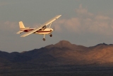
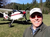
We took off out of Santa Paula in the 180 just after sunrise and headed toward Boulder City for breakfast and fuel. Joe launched in his Husky out of Camarillo at about the same time and joined us for a microwaved breakfast burrito at the Papillon Helicopters snack bar in Boulder City. There was an unbelievable amount of tour traffic at BVU, especially given that it was a Tuesday morning. Helicopters and Twin Otters were going in and out non-stop.
We launched for Grand Gulch, admiring Hoover Dam along the way (took the family there a while back - definitely worth doing), found Grand Gulch, made a couple of passes and landed. The runways are in decent shape - we used them both. Landed on 18-36, and departed into the wind on the SW crossing runway. Grand Gulch was a very cool look back in time.


It’s for sale!

After exploring for an hour or so we took off for Escalante. The winds had picked up a bit and were right down the shorter crosswind runway, so Joe went first with his bigger tires. He reported back that it was fine, so off we went.
I can't say enough good things about Chris and Mary at Escalante. Chris helped us fuel, tie down, offered us water, gave us some local insight into the weather and things to see, then drove us into town for lunch. More than we could have ever expected.
After giving us a tour of the town, Chris dropped us off where they rent off road vehicles. We tried to rent a Jeep for some exploring, but all of the Jeeps were already spoken for, so we walked back up the street and had a good lunch at Escalante Outfitters.
After lunch we started walking back toward the airport when Michael saw Chris' wife Mary across the street. She went above and beyond to run us back to the airport. Again, I can't say enough about them.
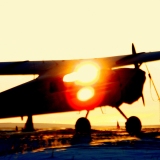
We killed another few hours waiting for the winds to die down. We took off at around 7:45pm, assuming that the winds would be tolerable at Mexican Mountain by the time we landed, just before sunset.
As we approached the south side of Mexican Mountain, things were not looking good. We had a very obvious crab, and when we overflew the airport at 600' or so we were getting pretty well beat up. I called Joe to tell him we couldn't land there, and we both began looking at alternates. We wanted to be on the ground by nightfall, giving us 30 min or so. Green River, Hanksville, Canyonlands, Mineral and Happy Canyon were all discussed, with Hanksville getting the nod because it had the lightest winds (200@7) reported via Foreflight.
Meanwhile, I had to pee like a mother. I gave Michael the controls and did the deed, managing to get most into the ziploc bag. Had it been number two, we'd have been screwed.
Turns out Joe was in the same predicament, but he was solo, pinching it off as he approached Hanksville. I pulled up the AWOS, only to hear the winds reported as 180@18G23. Crap, the runway is 8/26...
When I looked again at ForeFlight, it showed a 2600' north/south dirt runway at HVE that was in 'fair condition'. Joe arrived first and, despite his discomfort, made a pass over the dirt runway, reporting that it looked to be in good shape, but maybe a bit soft. We were just behind, entered a left base and landed. We pulled off the side and shut down. It was a little on the soft side, but not a problem even with 8.00s. Joe landed, dove out of the Husky so he could take care of business, then started back up and taxied to us.

There is *nothing* at the Hanksville airport. Nada. So we did what we came to do - camp. We pushed the airplanes off the side of the dirt runway, tied them down, set up camp, had dinner, told some lies and went to bed.


Wednesday morning was cool, calm and clear. We made some coffee, ate breakfast and packed up our gear. Looking in almost any direction, you'd never guess we were still on an airport.


Despite what ForeFlight says, the dirt runway is not 2600' long. More like 5000 x 400. It's just massive. The useable width is a bit narrower, but it's marked *really* wide. Rather than taxi a mile through soft dirt to get to the paved runway, we just took off from where we were.
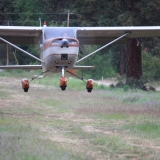
This time, Mexican Mountain was beautiful. I made a pass over the runway and saw Allen's (amacbean) 170 along with Cory's (grasstrippilot) 205 already there. I flew out of the west end of the canyon, turned around and landed. Joe landed in the Husky a few minutes later.


One of the springs in Spring Canyon

We met Stan, Allen and Cory and chatted for a while before they went on their way. Nice to meet some BCP folks.
Cory’s takeoff from Mexican Mountain (Sorry, Allen. Yours didn’t come out well)
We hiked up Spring Canyon to look at the petroglyphs, saw where Butch Cassidy shot it out with Sheriff Tuttle, and eventually ran out of space so we came back to eat lunch. It was at this point that we discovered biting flies. Nasty, tenacious little bastards that inexplicably only went after Michael and Joe. It was as if I was invisible to them. Not that I'm complaining.
After lunch we hiked out to the west, eventually looping back around toward the river. Michael was in the lead when he disturbed a huge swarm of flies. A grey cloud shot up, Michael started running for his life while the flies followed, eventually attacking Joe as well. Meanwhile, my WonderTwin bug repelling power was keeping them off me (might have also been my pants).
These flies are the most tenacious bugs I've ever seen. Michael and Joe ran a good half mile and a bunch of flies followed them the whole way. We finally resorted to swatting them with my towel, which slowly did the trick. Oddly, the biting flies really only attacked from the waist down. Very few issues from the waist up. Except for the one that bit my temple. That one hurt.
All in all, we hiked for several hours and aside from the flies, really enjoyed the day.
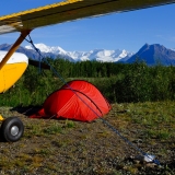
The next morning we packed up our stuff and headed to Happy Canyon. We landed around 8:30 and spent some time exploring the old cabin. Very cool to see. Also glad to see emergency food, water and coffee stashed inside, though the box of Tide might have been overkill.


Now the hike.
I've been looking at this hike for months. I've used several ways to try to get a good estimate of the distances involved, but it's very difficult to do with the many twists and turns of the wash. Straight line it's about 5.5 miles to the slot. Best I could come up with was 6-8 miles of hiking each way, 16 miles round trip, plus however far we ventured into the slot. Our original plan was to hike down, camp and return the next morning. After figuring that it was only 6-8 miles, we decided to lighten our loads and just do the round trip in one day. I was encouraged by the report here on BCP where they did just that.
Now, Michael and Joe hike a lot and have a pretty good gauge on how much water to bring. I don't, so I loaded up as much as I could carry - two 100 oz Camel bladders and two large Nalgene bottles - almost 300 oz total. Needless to say, I sweat more than most.
I used my iPhone and an app to record distance. Without cell coverage it doesn't have maps, but will still preserve our track and distance. I also had a DeLorme InReach that was tracking us in my Camelback.
So at 9:20 or so, off we went. It was a long hike.
Just getting off the Mesa is almost two miles of hiking down barely discernible soft sand roads - way longer than I thought. Once in the main wash, however, you can make good time. It's hard dirt for the most part, with short sections of softer sand. There are at least three springs where water is available, though they are concentrated within a mile or two of the airport mesa. Oddly, they are full of hundreds of tadpoles and the occasional frog - about the last thing I expected to see in the middle of the Utah desert.
Tadpoles!


The Pinnacle

The occasional footprint was the only thing that showed anyone had ever been here..

We had been walking for several hours using the USGS topo map for guidance, and it eventually became painfully clear that my 8 mile worst-case was a bit off.
7 miles - no slot
8 miles - no slot
9 miles - no slot.
Crap. We've come all this way, but might have to turn back. I just emptied my first Camel, the hike back is all uphill and we still don't know how much further it is. Finally, we see a slot! We enter, only to have it end in 50yds or so. This happens a couple of times and is messing with our minds. We really don't want to turn back when we're this close.
Finally, I see the actual slot. I look at my iPhone. 9.8 miles.


There's a 4 foot drop into the slot, and the rest is easy. We hike along the slot for another half-mile or so, and while impressive, it's not quite what I expected and we’re all quietly disappointed. Finally, we stop and sit for a few minutes to discuss how far we want to go. We power through a few Cliff Bars as we talk. My feet are starting to hurt and I'm well into my second Camel, so water is becoming a concern. We decide to wrap it up and head back. I pull out my iPhone to stop tracking - it reads 10.58 miles.


After I save the track, Michael wants to look at it. He stares at the screen and says 'hey, the river is right here! It's close!' I look at the track, and somehow a digital topo map is available. It must have saved it when I was looking at the app many weeks ago, and sure enough it shows us only 0.2 miles from the Dirty Devil River. Well crap, we can't stop now, so we all agree to continue to the river. (A lucky mistake – we were looking at where the Dirty Devil loops around just south of the slot. The actual confluence was over a mile further down. Had we realized this, I doubt we would have continued).

Maybe a hundred yards or so further down the slot, and it becomes truly astonishing. Otherworldly, even.


At each turn it gets better. And better. And better.


Michael and I were shooting pictures while Joe moved ahead, yelling back every time he came into a new section of the slot. This went on for another mile until we made it to the river.
It was one of the most beautiful things I've ever seen in my life. Just amazing.
And we were *this* close to bailing out less than 100 yds from it.
We spent 30 minutes or so at the Dirty Devil River. Joe and Michael had their bare feet in the water, and we're at the same time elated and concerned. The slot is better than we could have ever imagined, yet we realize this is now a 23+ mile hike - much further than any of us have ever done in one day.

We start heading back, through the slot and up the wash. Our feet hurt and our water supply is less than we'd like. With a few miles to go, Michael and I have slowed our pace, so Joe goes ahead.
All of us eventually run out of water. Joe was close enough to camp that it wasn't an issue. Michael and I filtered water from one of the springs to refill two bottles. The road back up the mesa is very hard to see, and all of us missed a turn at first, costing us some time. We eventually got back to the airplanes at 8:30pm, just before sunset. The gnats were ruthless, but at least they didn’t bite, and they were gone as the sun set.
Finally back at the top of the mesa, still a good half-mile to go..


Exhausted, we drank a bunch more water and ate dinner, reflecting on what we'd just done and seen. Between the three of us, we had about 3 gallons of water left in the airplanes. We setup camp and went to bed around 11pm. It was quiet and calm. The moon was just starting to light up the eastern sky.

Then, at about midnight, the wind started.
Very quickly, it was evident that there was no way we could depart in the morning if this kept up. While the airplanes were secured, one never sleeps well when the wind picks up like that. At the same time, while we had lots of food, Michael and I were dreading the 6-8 mile round trip to the spring to refill our water if we ended up stuck for more than another 24 hours or so.
At the same time, the winds re-stoked the fire to the point it was throwing glowing ash all over the place. Michael threw more sand on the remaining embers to keep it down.
Then it started to rain. Crap.
All of us jumped up to get our flies installed, hanging on to them as they fluttered horizontally like a cape. We snugged the tiedowns and retreated once again to our tents. At this point, everything in my tent was covered with fine silt, and the gusts were strong enough to flatten it against my face. Each time a gust came, you could hear it start to roar about 5 seconds before it arrived. Then we heard a VERY loud roar that built up over several seconds and we all thought we were in trouble. But the gust never came. It was an airliner.
After a very long night, morning arrived with calmer winds and very dark skies to the north and east. We really wanted to know what was going on weather-wise, as this was not in the forecast at all, but almost everything we had was useless without data. At about 5am, I sent a message with my InReach to two buddies to have them forward the TAFs for everything nearby. Knowing they probably wouldn’t be awake for a while, I managed to get ahold of a FedEx guy who relayed some AWOS info for us before he went out of range.
Finally our buddies started replying on the InReach and we were able to get a decent enough WX picture to launch with some confidence over to Escalante. After a shower and another Cliff Bar, we were on our way home.
As often happens, the best laid plans go to waste. We had planned and prepped, but not one day went as expected. In a way, that’s part of the adventure. It was a great trip that was over too soon. We were looking for adventure, and we got it. Nobody got hurt and no metal was bent.
Can’t wait to do it again.

Our route.