Here's the little lady a bit nervous about flying to the middle of no where with her old man who forgets where he put his wallet / car keys / child but thats another story.

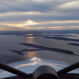
Flying North West at 6,500', climbing over the Great Dividing Range that runs nearly the full length of the East Coast of Australia. The mountain in the distance is called Mt Lindsey and is part of an extinct volcanic region that formed the topography where we live.

Fuel and lunch at Roma, a town now at the centre of gas mining projects. Had to get into a queue to land here, surprising because it is fairly remote and 10 years ago was a dirt strip. Behind me is a King Air from the Royal Flying Doctor Service, looking after remote stations that are impossible to transport patients from in cars.

Part of the sandstone Gorge at Canarvon.

Gets so hot toads fry mid thought.


Aboriginal art circa 3000 BC. The George was used for ceremonies, such as funerals and initiations, this rock art is about halfway up the Gorge.

Cooling my feet after a 12 kilometre walk. The water was crystal clear and freezing, the feet were numb after a couple of minutes, now to walk the 12k back to camp.

Heading back to the Queensland coast, this area is called the Glasshouse Mountains. Apparently they reminded someone on Captains Cooks ship(The Endeavour) of the glass kilns back in England in the 1770s.

To get around Brisbane International Airport you have to head out to sea and fly down the west coast of Morton and Stradbroke Islands.

Shipwrecks off Stradbroke Island, from here we headed south to our home strip around 40 minutes flying time. Got her home safe and sound
without losing anything.