kevbert wrote:Wow, how do they find such clueless people to fill all the government jobs?
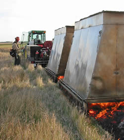
I finally got around to looking at it. It's where they tore up the ground running around with some equipment out in the sagebrush setting a backfire to stop a big blaze that was blowing in that direction. Naturally, the blaze never got to where they drove in the spiral patterns.
Look on Google Earth, and you will see where the fire went in some spots from west to east until it got to the road. It's easier to see if you use the historical imagery from 2001. Coordinates are 42.65, -119.50 .
Here's some more interesting patterns about five miles south along the French Glenn road, 42,59 -119.57. Educated guess is these are prescribe fire blocks, possibly a study area comparing results of mowing vs burning vs mowing and burning of sagebrush. If 58Skylane makes that recon trip I suspect he won't find soil disturbance in the spirals, Just fire scars.
If you look back throug the historical images in google earth the patterns seem to get very faint in some images. Those were taken in spring when the grass that replaced the sage after burning is green. The summer and fall images show up more defined due to the grass being cured.The spirals may have been lit with an ATV torch or possibly a helicopter with a helitorch.