Current Chicken Strip PIREP
Tue May 21, 2019 9:48 am


Tue May 21, 2019 11:21 am
Re: Current Chicken Strip PIREP
Hammer wrote:hamer wrote:Not sure how that is a bad thing? RAF is a great organization as far as I know. Charting it and having RAF maintain it sounds like an ideal way to preserve it.
RAF maintaining it is great...charting it is where the problem will be. It simply cannot accommodate a larger volume of traffic than it's already receiving. Scores of additional users aren't going to preserve it, they're going to ruin it.
The CS isn't difficult, but it's several steps above any other charted, public airstrip on the sectional. One-way approach, soft, short surface, sporadic and often STRONG winds, plus some simply ridiculous DA conspires to wreck a couple airplanes every year... And those were the pilots that found it without it being on the chart. When your average renter takes the flight school 172 for a spin and decides that the CS is an interesting looking place to go for the afternoon, it's going to get worse. Much worse.
Accidents, especially accidents with fatalities, WILL close the strip. Pilots and the RAF can raise all the stink they want, but if the Park Super decides there's more political or legal exposure to leaving it open than there is to closing it, they'll close it. You'll notice it's not part of the Saline Valley Management Plan....they don't have to re-write the plan to change their standing on the CS.
It's a small strip with a very small parking area. Just about every time a new pilot comes in they turn around in a direction that sand-blasts any other airplanes and camps. Given that they're blowing crushed volcanic cinders, that's not a small thing. Inexperienced pilots using the short/soft field departure taught in basic training create a cloud of dust and pulverized propeller aluminum big enough to be seen from space. There are no toilets and no garbage pick-up, and even without being charted, regular users are constantly cleaning up after other less considerate visitors.
Pilots who want to find strips like the CS because they're looking for a remote place to visit don't have any trouble finding them. But advertising it to everyone in So Cal with an airplane reserved for the afternoon and a sectional is a big mistake.
It's pretty academic to me...I don't live in that part of the world anymore and don't plan to ever return, but when I did live in CA my wife and I were the single biggest users of the CS for over a decade. We've camped there every month of the year, often racking up a couple months use during the year. We saw a lot of things during that time, none of which suggested that more inexperienced users was going to be a good thing for the CS.
I'll say it again: if the number of accidents, especially accidents with injuries or fatalities increases, the Park will close the strip. I can already hear the scores of people screaming "they can't do that...it's OUR land...they made an agreement", but they can, and they will. The simplest way to prevent that is to keep it off the chart.
Thanks for the insight, I'm new to the area so I'm still figuring things out.

Mon Aug 19, 2019 11:25 am
Re: Current Chicken Strip PIREP
https://www.nps.gov/deva/learn/news/sal ... CZk_JwtvDk
News Release Date: August 19, 2019
Contact: Abby Wines, 760-786-3221
DEATH VALLEY, CA – Death Valley National Park announced that Saline Valley’s “Chicken Strip” Airfield is now officially authorized, as of August 19, 2019. This legally sanctions the long-established use of this backcountry airstrip.
The Saline Valley Warm Springs Airfield, commonly known as the Chicken Strip, is an unpaved landing strip that has been in use for decades. For most of that time, the land was managed by the Bureau of Land Management (BLM), which did not prohibit use of the airstrip.
The Chicken Strip was part of about one million acres of land that were transferred to Death Valley National Park by the California Desert Protection Act in 1994. This transfer from BLM to National Park Service (BLM) also closed the airstrip by default. Lands and waters of the National Park Service are closed to operation of aircraft unless specifically authorized by a special regulation. However, the closure was never enforced and many park staff were not aware that the Chicken Strip was not authorized.
“This special regulation is really a deregulation,” explained Mike Reynolds, Death Valley National Park Superintendent. “It removes any question about the legality of the airfield’s use by visitors. We believe this is a common sense approach that corrects a regulatory technicality.”
The Chicken Strip has been used by an average of 47 planes per year recently. Some pilots use it to access the nearby Warm Springs. Others are drawn by the challenge of the airstrip itself.
Volunteers with the Recreation Aviation Foundation (RAF) maintain the airstrip at no cost to the taxpayers. “The RAF and the NPS have been successfully partnering for nearly ten years to make access to [the Chicken Strip] safe and available to the aviation community,” RAF board chairman John McKenna said.
The Federal Register posting is available at: https://www.federalregister.gov/documen ... f-airstrip.
Mon Aug 19, 2019 4:59 pm
Re: Current Chicken Strip PIREP
ebag wrote:https://www.nps.gov/deva/learn/news/saline-valley-s-chicken-strip-airfield-authorized.htm?fbclid=IwAR1sia6juYO3lU-y231eG0vanVtWblq0iJj7tBoMr5ANU4bDOCZk_JwtvDk
News Release Date: August 19, 2019
Contact: Abby Wines, 760-786-3221
DEATH VALLEY, CA – Death Valley National Park announced that Saline Valley’s “Chicken Strip” Airfield is now officially authorized, as of August 19, 2019. This legally sanctions the long-established use of this backcountry airstrip.
The Saline Valley Warm Springs Airfield, commonly known as the Chicken Strip, is an unpaved landing strip that has been in use for decades. For most of that time, the land was managed by the Bureau of Land Management (BLM), which did not prohibit use of the airstrip.
The Chicken Strip was part of about one million acres of land that were transferred to Death Valley National Park by the California Desert Protection Act in 1994. This transfer from BLM to National Park Service (BLM) also closed the airstrip by default. Lands and waters of the National Park Service are closed to operation of aircraft unless specifically authorized by a special regulation. However, the closure was never enforced and many park staff were not aware that the Chicken Strip was not authorized.
“This special regulation is really a deregulation,” explained Mike Reynolds, Death Valley National Park Superintendent. “It removes any question about the legality of the airfield’s use by visitors. We believe this is a common sense approach that corrects a regulatory technicality.”
The Chicken Strip has been used by an average of 47 planes per year recently. Some pilots use it to access the nearby Warm Springs. Others are drawn by the challenge of the airstrip itself.
Volunteers with the Recreation Aviation Foundation (RAF) maintain the airstrip at no cost to the taxpayers. “The RAF and the NPS have been successfully partnering for nearly ten years to make access to [the Chicken Strip] safe and available to the aviation community,” RAF board chairman John McKenna said.
The Federal Register posting is available at: https://www.federalregister.gov/documen ... f-airstrip.
Whooo that is awesome - great job RAF
Mon Aug 19, 2019 6:51 pm
Re: Current Chicken Strip PIREP
Kinda crazy how long it takes sometimes to change some wording on some documents to make legitimate something that’s been legitimate for a really long time . Good deal I guess . Thanks to all who made the effort .Sure beats the alternative of no more chicken strip .

vail
Tue Aug 20, 2019 6:52 am
Re: Current Chicken Strip PIREP
Thanks "ebag" for getting the word out. It's REAL, it's done, it's official. "FINALLY" 
- pacerpilot offline
- Posts: 199
- Joined: Mon Feb 23, 2009 10:48 pm
- Location: Kernville, calif.
- Aircraft: PA-22/20
Wed Oct 30, 2019 5:21 pm
Re: Current Chicken Strip PIREP
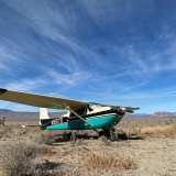
Landed at Chicken Strip today. It's in excellent condition.
Pierre

Pierre
- Pierre_R offline


- Posts: 312
- Joined: Mon Sep 30, 2013 3:17 am
- Location: Minden, Northern Nevada
- FindMeSpot URL: https://share.findmespot.com/shared/fac ... 5KFquxzBYq
- Aircraft: 1964 C182 IO550 on Aerocet 3400's.
Aerotrek A220.
TBM 850
Thu Feb 04, 2021 11:39 am
Re: Current Chicken Strip PIREP
Recently noted on one of the regular DV forums that the Chicken Strip now has an "X" at each end of the runway. It is visible on the most recent google earth/maps satellite images.
It also looks as though the strip could use some dragging too.
It also looks as though the strip could use some dragging too.
Thu Feb 04, 2021 11:49 am
Re: Current Chicken Strip PIREP
Could be damage from the big storms in the Sierra recently? . Not sure if the precip made it over there or not , but a closer look would be in order perhaps .
vail
Fri Feb 05, 2021 12:51 pm
Re: Current Chicken Strip PIREP
Maybe. Or someone took it upon themselves to X it out when the Park closed its campgrounds and facilities under the State's COVID order.
Fri Feb 05, 2021 3:59 pm
Re: Current Chicken Strip PIREP
CAVU wrote:Maybe. Or someone took it upon themselves to X it out when the Park closed its campgrounds and facilities under the State's COVID order.
I've been there since the covid restrictions (hot springs and campgrounds shut down etc) and the airstrip was not X'd.
Fri Feb 05, 2021 4:08 pm
Re: Current Chicken Strip PIREP
Don't look to Google Earth for current conditions. Images will be a minimum of 6 months old, sometimes a lot older. Images for Death Valley N.P. are dated from 2013 to 2017, some of them are undated. The Chicken Strip is dated 2016, there were X's on it at that time, things have changed.
Dale
Gravity Strikes Again.
Gravity Strikes Again.
DISPLAY OPTIONS
Who is online
Users browsing this forum: No registered users and 1 guest
Latest Features
-
Live to Tell
A Minnesota pilot is surprised to learn that the sudden asymmetric drag of an out-of-rig ski can…Read More -
Creators
Working in some of the Yukon's most beautiful and remote environments, photographer Simon Blakesley captures aircraft in…Read More -
Aircraft Ownership and Maintenance
Upgrading to big tires can make a huge difference in backcountry performance, but with those gains come…Read More -
Tales from Yesteryear
In this tale from bush flying yesteryear, Don Cogger signs up to help Atlee Dodge Jr recovery…Read More


Latest Knowledge Base
-
Destinations
A regional guide with ideas for winter camping destinations in California, Nevada, New Mexico, and Arizona.Read More -
Aircraft
Finding an affordable aircraft that can handle the backcountry for $80K or less? A challenge for sure, but with the…Read More -
Aircraft
01.29.2018 - Zane - Updated tire diameter graphic to add 8.50x10 Guide to tires for use in the backcountry and off-airport landing…Read More -
Pilots
12.22.2013 - Initial article format Operating aircraft on skis and negotiating a snow-covered landscape is an entirely unique skillset and environment.…Read More


