After reading that stuff from NWS, and a few other sources, the way I imagine it is that once fully developed, the rapid, concentrated updraft converges near the surface, at the vortex. The downdrafts are peripheral, surrounding the vortex. As a glider pilot, you know that where there is rising air there is also descending air nearby, a sort of displacement reaction. Perhaps the surrounding downdrafts of a tornado, under this supercell TS, both contribute to and are perpetuated by the updrafting vortex.
Also, it seems (from what has been written) that tornadoes occur mostly during the mature stage of TS when convection is strongest, and what you are describing is the dissipating stage, characterized by downdraft and divergence.
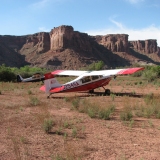
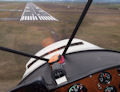
Fascinating stuff. Here's a little better photo with description of the original post "dusty." I can tell you that would want no part of flying airplanes on that day.
Fly Through a Dust Devil?


Mon Apr 26, 2010 4:25 pm
Re: Fly Through a Dust Devil?
EZFlap wrote:I admit I do not have the scientific or field training to argue with the NWS. There are indeed some sharp folks who study this stuff all day. However, if I happened to be standing next to a NWS tornado researcher, I'd ask the following question:
1) We know that tornadoes develop because warm air and moisture rise up high, cool off, and sink back down violently. We know for sure that this phenomenon is the overall "engine" or energy source for the tornado. So the air must rise up first, essentially storing potential energy, "charging up" the storm.
2) Then a heat release or heat exchange occurs. This triggers the release of all that stored energy. I think we know that for sure too.
3) Then the energy is released, and this entire cold wet airmass comes down like an avalanche.
So the big question in my mind is... if the tornado is indeed an updraft (as the NWS quote indicates), then how could any significant updraft possibly form in the face of that enormous downward avalanche of air? The heat/rising cycle has already been completed by the time the cold wet air starts falling. This sounds like something along the lines of a surfer being able to surf against (and burst through) a pretty large tsunami to me.
If Mark Grubb is still reading this forum thread, I believe he is in a position to ask the opinion of two very qualified experts about this (Walt Rogers and Dan Gudgel). They are both highly qualified aviation weather types, and both have a large number of hours in small aircraft.
EZFLAP...the downdrafts (cold air) usually preceed the storm as a large downward blast of air..this blows up a lot of dirt before the rain, then comes the rain, and possibly hail (but not in every case), then comes the tornado..usually at the back edge of the cloud (but not always). Remember what started this phenomina is the rising warm air that produces the cloud as the warm moist air passes the dewpoint. When moisture in the cloud gets heavier than the updraft, it produces rain. If the updraft is very strong, it pushes the moisture even higher, longer and that produces hail when the updraft can no longer hold it aloft and down it comes, cold air and all. So what you have is a storm with updrafts and downdrafts and circular motion and when the whole mess gets violent enough it will produce rain, high winds on the ground, hail, and tornados. I have always been facinated with thunder storms and have probably seen 100 tornados and they are all different but when you see one, especially if you are close, you have no doupt what they are. In June of '99 I watched a small storm develope into a monster within about 20 minutes..baseball sized hail, 80mph wonds for 20 minutes..did $40,000 damage to my house. I went out and took videos as it was approaching and this cloud was dark as night. When it hit, it was pitch back outside while the hail shook the house..we later determined from the damage a tornado had hit about a quarter mile from my house. I don't have to read about severe weather on the plains, I've lived through it most of my life. If anybody would like to witness it first hand, spend some time in tornado alley..it will make a believer out of you!
'05 7GCBC High Country Explorer
The faster I go , the farther behind I get.
The faster I go , the farther behind I get.
Mon Apr 26, 2010 7:45 pm
Re: Fly Through a Dust Devil?
HiC,
I had to come read your post as it relates to some of the weather watching we discussed. You gave a very good description of what happens. We get some big ones here too, we lost the whole town of Spencer SD in '98 and then Manchester in '03 but the most famous tornado description ever was by a man who once lived close by in Aberdeen. His name was Frank Baum.
To this day I'm still scared of tornadoes.
Lynn Sanderson (Dirtstrip) passed away from natural causes in May 2013. He was a great contributor and will be missed dearly.
Tue Apr 27, 2010 3:34 pm
Re: Fly Through a Dust Devil?
This is what happens when ya fly through a dust devil in a Ford Tri Motor...
- Coyote Ugly offline
- Posts: 897
- Joined: Thu Jan 03, 2008 9:51 pm
- Location: Middle of Nevada (Middle of Nowhere?)
Tue May 04, 2010 2:40 pm
Re: Fly Through a Dust Devil?
Just say no.
Aside from the obvious weather problems, consider the damage the sand blasting will do to your paint, fabric, aluminum, windscreen, etc. Now think about that air filter... what happens if that gets plugged up?
Aside from the obvious weather problems, consider the damage the sand blasting will do to your paint, fabric, aluminum, windscreen, etc. Now think about that air filter... what happens if that gets plugged up?
- LostUpNorth offline
- Posts: 6
- Joined: Tue Jun 05, 2007 8:55 am
- Location: Wisconsin
Tue Oct 19, 2010 6:53 pm
Re: Fly Through a Dust Devil?
http://www.youtube.com/watch?v=2iBjqFJsraM
- Student BCP offline
- Posts: 334
- Joined: Mon Oct 08, 2007 6:50 pm
- Location: Eagle River
- Aircraft: PA 22/20
Wed Oct 20, 2010 8:20 am
Re: Fly Through a Dust Devil?
Student BCP wrote::shock:I came across this after watching Zane's "Fuselage not required"
http://www.youtube.com/watch?v=2iBjqFJsraM
What service! The dust devil comes to you! Looked like it could have set them back down on their heads. That looked scarier to me than the zip line video.
tom
- Savannah-Tom offline
- Posts: 891
- Joined: Mon Mar 06, 2006 3:26 pm
- Location: Corvallis, OR
DISPLAY OPTIONS
Who is online
Users browsing this forum: No registered users and 2 guests
Latest Features
-
Live to Tell
A Minnesota pilot is surprised to learn that the sudden asymmetric drag of an out-of-rig ski can…Read More -
Creators
Working in some of the Yukon's most beautiful and remote environments, photographer Simon Blakesley captures aircraft in…Read More -
Aircraft Ownership and Maintenance
Upgrading to big tires can make a huge difference in backcountry performance, but with those gains come…Read More -
Tales from Yesteryear
In this tale from bush flying yesteryear, Don Cogger signs up to help Atlee Dodge Jr recovery…Read More


Latest Knowledge Base
-
Destinations
A regional guide with ideas for winter camping destinations in California, Nevada, New Mexico, and Arizona.Read More -
Aircraft
Finding an affordable aircraft that can handle the backcountry for $80K or less? A challenge for sure, but with the…Read More -
Aircraft
01.29.2018 - Zane - Updated tire diameter graphic to add 8.50x10 Guide to tires for use in the backcountry and off-airport landing…Read More -
Pilots
12.22.2013 - Initial article format Operating aircraft on skis and negotiating a snow-covered landscape is an entirely unique skillset and environment.…Read More


