Knowing the Boeing Company well, they always try to upsell, everything. I can see them trying to maximize every ounce of work, down to see the real pressure points on users and wallets.
I've used brand F and G, and really like brand G. With G I get rastored charts, just two levels of service, easy electronic logbook, and works flawlessly with my GDL-52.
Foreflights changes :(
Mon Dec 19, 2022 7:41 am
- 48Stinson1083 offline
- Posts: 83
- Joined: Wed Feb 09, 2022 4:19 pm
- Location: Maple Valley
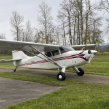
- Aircraft: Stinson 108-3
Mon Dec 19, 2022 9:19 am
Re: Foreflights changes :(
Does GP have those cell-predicting dots that FF used to have?
Mon Dec 19, 2022 10:07 pm
Re: Foreflights changes :(
I know about the 4 color radar, not a fix
Would say I’d be happy to talk to FF or BA about issues in foreflight, but I don’t think they care
Would say I’d be happy to talk to FF or BA about issues in foreflight, but I don’t think they care
- NineThreeKilo offline
- Retired
- Posts: 1679
- Joined: Thu Dec 31, 2009 8:16 pm
- Location: _
Fri Dec 23, 2022 12:04 pm
Re: Foreflights changes :(
daedaluscan wrote:I am so invested in ForeFlight that I just keep paying.
What hurts for me is it not being flexible in terms of subscriptions. Four months to install my O360, or three months in Europe away from the plane and I just keep paying. And realistically I only go the the US in the summer but I have to buy a year. Just seems like poor customer service to me.
Every winter they have sales but not for renewal, only for new subsribers. Nothing for those of us who've been with them for years.
Thu Dec 29, 2022 9:56 pm
Re: Foreflights changes :(
My biggest beef with FF is that if I connect it to my ADS-B, a GDL52, then i no longer have the option to use my cellular weather. It will only use ADS-B weather. The problem is that in Canada we don’t get ADS-B weather. I like the ADS-B for traffic, but I prefer weather over traffic. So I can’t use ADS-B. which sucks. With GP I can pick which weather input I want. So I can get weather and traffic. But I don’t get satellite maps, which we use for spraying… so I end up using both, depending if I’m ferrying or flying. I much prefer the GP log book.


Sun Jan 01, 2023 5:12 pm
Re: Foreflights changes :(
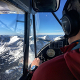
I used to be proud that I worked for the current owner of Foreflight. Since July I've been flying part 135 out of Bethel, AK and it didn't take me more than a couple of two week shifts up there before I drank the kool aid and sucked up my bias against Apple products (I've got my reasons) and bought an iPad mini with foreflight - plus a Sentry. No question it contributes to my (and my passenger's) safety on a daily basis.
Being able to check weather at a destination 100 miles out is nice. The Hazard Advisor is priceless when near actual rocks up near the Yukon River (set to "helicopter" because our cruising altitudes rarely have 4 digits)
But...
This past shift I was sent to Newtok, which I generally get sent to a couple of times per week. The runway is 15-32, narrow and full of potholes the entire length. Making it even more sporty, a 25 knot crosswind isn't unusual and of course this time of year it is covered in ice. Good times, but these people need their pizza rolls and Gatorade. Upon entering the identifier the line snapped to Mertarvik.
A bit of history for the unfamiliar, the village of Newtok is reported to be "sinking". It's on the outside of a bend in the Baird Inlet, subject to tidal flow twice per day, so it isn't sinking as much as the shoreline is rapidly eroding. It is causing the permafrost under the tundra to melt so that is where the sinking action is coming from.
If you want more of the story there is a documentary put out by Patagonia https://www.youtube.com/watch?v=BohwgBqAwJc
There is a new village called Mertarvik, still being built on the inside of the bend in the Baird. It avoids the erosion problems but if you watch the video you'll find that some people are stubborn and will never leave Newtok. Previously we landed on the quarry road at Mertarvik, which is even more sporty because it is quite literally a straight section of gravel road which falls off on both sides. All summer long the DOT was building a new, modern gravel runway up the hill and it just opened last month.
It's new enough that if you look on Google Maps using the satellite view, you can see Newtok and the runway, but Mertarvik is outdated and only shows the quarry road and very few buildings. The new runway is typical of the other DOT runways in SW Alaska at a fat 40-75' wide and 3x longer than we need.
When the Foreflight app first directed me to Mertarvik I saw that both runways used the same four letter identifier PAEW. I figured there was some typographical mistake and sought to report the error to Foreflight.
Yesterday I received a reply which seemed to be confused by my claim that two airports shared the same identifier and said that they didn't remove Newtok, they just modified it. They also said they just use information from the FAA, and that if I had an issue with that I should contact the FAA (which makes me understand why so many people dislike the new ownership)
Calling up Forelight Web I see why they may have been confused by my inquiry, because as of December they made it even worse!
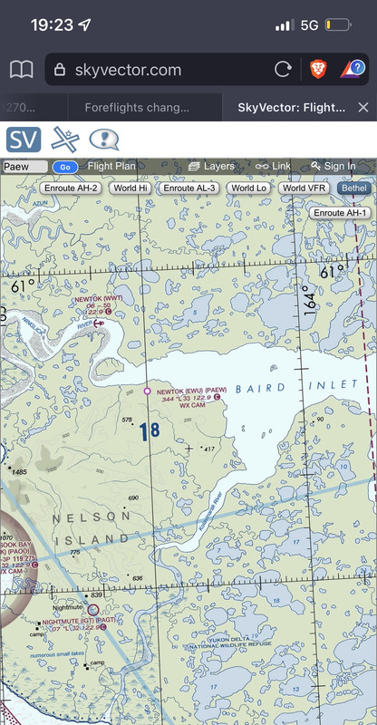
Here's the expired sectional view I used in November showing the two villages, but with both using the same identifier:

You can see Mertarvik across the water to the SE, and the old quarry runway still identified.
Here is what it the sectional view looks like today:

According to the FAA (and Foreflight), Mertarvik is now Newtok, and old Newtok doesn't exist except for the seaplane "runway". Next time I fly there I'll make sure to let them know.
Being able to check weather at a destination 100 miles out is nice. The Hazard Advisor is priceless when near actual rocks up near the Yukon River (set to "helicopter" because our cruising altitudes rarely have 4 digits)
But...
This past shift I was sent to Newtok, which I generally get sent to a couple of times per week. The runway is 15-32, narrow and full of potholes the entire length. Making it even more sporty, a 25 knot crosswind isn't unusual and of course this time of year it is covered in ice. Good times, but these people need their pizza rolls and Gatorade. Upon entering the identifier the line snapped to Mertarvik.
A bit of history for the unfamiliar, the village of Newtok is reported to be "sinking". It's on the outside of a bend in the Baird Inlet, subject to tidal flow twice per day, so it isn't sinking as much as the shoreline is rapidly eroding. It is causing the permafrost under the tundra to melt so that is where the sinking action is coming from.
If you want more of the story there is a documentary put out by Patagonia https://www.youtube.com/watch?v=BohwgBqAwJc
There is a new village called Mertarvik, still being built on the inside of the bend in the Baird. It avoids the erosion problems but if you watch the video you'll find that some people are stubborn and will never leave Newtok. Previously we landed on the quarry road at Mertarvik, which is even more sporty because it is quite literally a straight section of gravel road which falls off on both sides. All summer long the DOT was building a new, modern gravel runway up the hill and it just opened last month.
It's new enough that if you look on Google Maps using the satellite view, you can see Newtok and the runway, but Mertarvik is outdated and only shows the quarry road and very few buildings. The new runway is typical of the other DOT runways in SW Alaska at a fat 40-75' wide and 3x longer than we need.
When the Foreflight app first directed me to Mertarvik I saw that both runways used the same four letter identifier PAEW. I figured there was some typographical mistake and sought to report the error to Foreflight.
Yesterday I received a reply which seemed to be confused by my claim that two airports shared the same identifier and said that they didn't remove Newtok, they just modified it. They also said they just use information from the FAA, and that if I had an issue with that I should contact the FAA (which makes me understand why so many people dislike the new ownership)
Calling up Forelight Web I see why they may have been confused by my inquiry, because as of December they made it even worse!
Here's the expired sectional view I used in November showing the two villages, but with both using the same identifier:
You can see Mertarvik across the water to the SE, and the old quarry runway still identified.
Here is what it the sectional view looks like today:
According to the FAA (and Foreflight), Mertarvik is now Newtok, and old Newtok doesn't exist except for the seaplane "runway". Next time I fly there I'll make sure to let them know.
Sun Jan 01, 2023 5:25 pm
Re: Foreflights changes :(
aftCG wrote:I used to be proud that I worked for the current owner of Foreflight. Since July I've been flying part 135 out of Bethel, AK and it didn't take me more than a couple of two week shifts up there before I drank the kool aid and sucked up my bias against Apple products (I've got my reasons) and bought an iPad mini with foreflight - plus a Sentry. No question it contributes to my (and my passenger's) safety on a daily basis.
Being able to check weather at a destination 100 miles out is nice. The Hazard Advisor is priceless when near actual rocks up near the Yukon River (set to "helicopter" because our cruising altitudes rarely have 4 digits)
But...
This past shift I was sent to Newtok, which I generally get sent to a couple of times per week. The runway is 15-32, narrow and full of potholes the entire length. Making it even more sporty, a 25 knot crosswind isn't unusual and of course this time of year it is covered in ice. Good times, but these people need their pizza rolls and Gatorade. Upon entering the identifier the line snapped to Mertarvik.
A bit of history for the unfamiliar, the village of Newtok is reported to be "sinking". It's on the outside of a bend in the Baird Inlet, subject to tidal flow twice per day, so it isn't sinking as much as the shoreline is rapidly eroding. It is causing the permafrost under the tundra to melt so that is where the sinking action is coming from.
If you want more of the story there is a documentary put out by Patagonia https://www.youtube.com/watch?v=BohwgBqAwJc
There is a new village called Mertarvik, still being built on the inside of the bend in the Baird. It avoids the erosion problems but if you watch the video you'll find that some people are stubborn and will never leave Newtok. Previously we landed on the quarry road at Mertarvik, which is even more sporty because it is quite literally a straight section of gravel road which falls off on both sides. All summer long the DOT was building a new, modern gravel runway up the hill and it just opened last month.
It's new enough that if you look on Google Maps using the satellite view, you can see Newtok and the runway, but Mertarvik is outdated and only shows the quarry road and very few buildings. The new runway is typical of the other DOT runways in SW Alaska at a fat 40-75' wide and 3x longer than we need.
When the Foreflight app first directed me to Mertarvik I saw that both runways used the same four letter identifier PAEW. I figured there was some typographical mistake and sought to report the error to Foreflight.
Yesterday I received a reply which seemed to be confused by my claim that two airports shared the same identifier and said that they didn't remove Newtok, they just modified it. They also said they just use information from the FAA, and that if I had an issue with that I should contact the FAA (which makes me understand why so many people dislike the new ownership)
Calling up Forelight Web I see why they may have been confused by my inquiry, because as of December they made it even worse!
Here's the expired sectional view I used in November showing the two villages, but with both using the same identifier:
You can see Mertarvik across the water to the SE, and the old quarry runway still identified.
Here is what it the sectional view looks like today:
According to the FAA (and Foreflight), Mertarvik is now Newtok, and old Newtok doesn't exist except for the seaplane "runway". Next time I fly there I'll make sure to let them know.
Interesting here’s it on sky vector. Who I don’t think has anything to do with FF/BA
- NineThreeKilo offline
- Retired
- Posts: 1679
- Joined: Thu Dec 31, 2009 8:16 pm
- Location: _
Sun Jan 01, 2023 6:54 pm
Re: Foreflights changes :(
All these outfits HAVE to get their map data, identifiers, etc from the FAA. ForeFlight CAN’T publish map data that’s not provided by the FAA, for obvious liability reasons.
I’d be calling the FAA.
MTV
I’d be calling the FAA.
MTV

Sun Jan 01, 2023 7:23 pm
Re: Foreflights changes :(
I understand and I guess I'm just whining. If FF/BA became aware of a database error you'd think they would have a hotline to the FAA to coordinate a correction. I did a quick search and it says to call the FAA or walk into the FSDO.
Seriously, no way to just submit an error by email in 2023?
Seriously, no way to just submit an error by email in 2023?
Sun Jan 01, 2023 9:11 pm
Re: Foreflights changes :(
aftCG wrote:I understand and I guess I'm just whining. If FF/BA became aware of a database error you'd think they would have a hotline to the FAA to coordinate a correction. I did a quick search and it says to call the FAA or walk into the FSDO.
Seriously, no way to just submit an error by email in 2023?
What do you expect, it’s not like we pay over 25% of our income to the feds…oh wait lol
If the FAA was held to half the standard of the private sector they would have gone out of business within a few months
It would be cool if we could hold the FAA to just 1/10 the level of discretion they hold us self sustained private sector working airmen to
- NineThreeKilo offline
- Retired
- Posts: 1679
- Joined: Thu Dec 31, 2009 8:16 pm
- Location: _
Sun Jan 01, 2023 9:22 pm
Re: Foreflights changes :(
mtv wrote:All these outfits HAVE to get their map data, identifiers, etc from the FAA. ForeFlight CAN’T publish map data that’s not provided by the FAA, for obvious liability reasons.
I’d be calling the FAA.
MTV
Reminds me of
GS’s are all about do the min, keep their heads down for 30yrs to their pensions
Back in my medevac days we had a issue with a hospital, they would have calls for us, but it was night and bad weather and the approach was NA at night, I spear headed finding the issue, which was a few trees, the very large medevac company I worked for teamed up with locals and the property owners, we removed the trees, the FAA couldn’t be bothered to verify the issue was resolved and remove the restriction, even knowing this was for life saving medevac flights….it’s been over half a decade, just looked still NA at night
- NineThreeKilo offline
- Retired
- Posts: 1679
- Joined: Thu Dec 31, 2009 8:16 pm
- Location: _
Mon Jan 02, 2023 6:54 am
Re: Foreflights changes :(
aftCG wrote:I understand and I guess I'm just whining.
This entire thread is just whining. You actually have Flight Service Stations still…call them, or now this’ll be a whine about the FAA thread…..
MTV
Mon Jan 02, 2023 8:29 am
Re: Foreflights changes :(
mtv wrote:aftCG wrote:I understand and I guess I'm just whining.
This entire thread is just whining. You actually have Flight Service Stations still…call them, or now this’ll be a whine about the FAA thread…..
MTV
Bringing issues to light for others to know about is one of the things encouraged in aviation, discussing the FAA charts dropping airports or FF dropping weather products and features is no more whining than giving a pirep…
A FSS is not a EFB
- NineThreeKilo offline
- Retired
- Posts: 1679
- Joined: Thu Dec 31, 2009 8:16 pm
- Location: _
Tue Jan 03, 2023 9:55 am
Re: Foreflights changes :(
Follow up: Maybe there's hope after all. I had sent the same two images I posted above to the person at Foreflight and just received an email thanking me for clarification. They said they will contact the FAA and get it straightened out.
Yay.
Any bets that neither runway will be on the next revision?
Yay.
Any bets that neither runway will be on the next revision?
Tue Jan 03, 2023 7:13 pm
Re: Foreflights changes :(
And another update. I got a call from a woman at Foreflight today asking very specific details about the mapping error so she could work the the FAA to get it fixed. When she was sure she understood the issue she told me she and a coworker would work with the FAA, but it might not make it in time for this very next chart revision.
My faith in the process has been restored.
My faith in the process has been restored.
Tue Jan 03, 2023 8:34 pm
Re: Foreflights changes :(
I wonder if this is not a mapping error, but actually a decision by the state of Alaska to move the official airport location/identifier
Tue Jan 03, 2023 10:20 pm
Re: Foreflights changes :(
asa wrote:I wonder if this is not a mapping error, but actually a decision by the state of Alaska to move the official airport location/identifier
Doesn't matter. I'll still be delivering good there 5 years from now and it will be called Newtok. And Mertarvik will be a few miles away and has its own brand new airport.
Wed Jan 04, 2023 6:55 am
Re: Foreflights changes :(
aftCG wrote:And another update. I got a call from a woman at Foreflight today asking very specific details about the mapping error so she could work the the FAA to get it fixed. When she was sure she understood the issue she told me she and a coworker would work with the FAA, but it might not make it in time for this very next chart revision.
My faith in the process has been restored.
Nice!
We’ll here’s hoping for the best
- NineThreeKilo offline
- Retired
- Posts: 1679
- Joined: Thu Dec 31, 2009 8:16 pm
- Location: _
DISPLAY OPTIONS
Who is online
Users browsing this forum: No registered users and 0 guests
Latest Features
-
Live to Tell
A Minnesota pilot is surprised to learn that the sudden asymmetric drag of an out-of-rig ski can…Read More -
Creators
Working in some of the Yukon's most beautiful and remote environments, photographer Simon Blakesley captures aircraft in…Read More -
Aircraft Ownership and Maintenance
Upgrading to big tires can make a huge difference in backcountry performance, but with those gains come…Read More -
Tales from Yesteryear
In this tale from bush flying yesteryear, Don Cogger signs up to help Atlee Dodge Jr recovery…Read More


Latest Knowledge Base
-
Destinations
A regional guide with ideas for winter camping destinations in California, Nevada, New Mexico, and Arizona.Read More -
Aircraft
Finding an affordable aircraft that can handle the backcountry for $80K or less? A challenge for sure, but with the…Read More -
Aircraft
01.29.2018 - Zane - Updated tire diameter graphic to add 8.50x10 Guide to tires for use in the backcountry and off-airport landing…Read More -
Pilots
12.22.2013 - Initial article format Operating aircraft on skis and negotiating a snow-covered landscape is an entirely unique skillset and environment.…Read More


