Hah Hah. I'm so dumb. I just looked and the map posted above is the same one I'm talking about. I don't know anything about a Chukar Flat on the John Day, though.
tom
Forgotten Airstrips: Fish Creek, Oregon
Fri Aug 08, 2008 4:54 pm
- Savannah-Tom offline
- Posts: 891
- Joined: Mon Mar 06, 2006 3:26 pm
- Location: Corvallis, OR
Sun Aug 10, 2008 2:34 pm
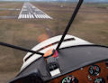
Over-flew the Fish Creek airstrip this morning. Hangar Trash went with me, but I don't know if he took pictures or not. Saw some really pretty water falls just west of the upper end of the lake on the Clackamas.
The Fish Creek Airstrip is way up above the river, on a bench. It is about 2200 feet long. The roads to get to it are twisty dirt/gravel. It is very overgrown with brush and small trees. Looks to me like it would take a lot of work to get it serviceable. Even all cleaned up, I'm not sure how desirable it would be. It would be a hell of a hike to get to the river. Seems like all you could do up there is dry camp and say, "I've been there". It is out of the way enough that I can't imagine too many people coming up there to bug you.
In the next week or two, I hope to check out the airstrip on the John Day, and the one on the Deschutes.
tom
- Savannah-Tom offline
- Posts: 891
- Joined: Mon Mar 06, 2006 3:26 pm
- Location: Corvallis, OR
Sun Aug 10, 2008 3:15 pm
Tom,
When you go over to Chukar Flats and Deschutes, can you shoot some pictures from altitude and/or some video (especially if you land them)?
I hate to always be the guy asking for people to take pics, shoot video, post pireps, etc - but that IS my job as Zane has recently changed my BCP title officially to Airstrip Database Manager!
- chrisg offline
- Airstrip Database Manager
- Posts: 220
- Joined: Tue Jan 01, 2008 9:04 pm
- Location: Coeur d'Alene, Idaho
Chris
http://www.shortfield.com - Backcountry Airstrip Database
https://discord.gg/HNHKeDE - Groundfall - Bush Flying Video Game
http://www.shortfield.com - Backcountry Airstrip Database
https://discord.gg/HNHKeDE - Groundfall - Bush Flying Video Game
Sun Aug 10, 2008 4:56 pm
I will. Got a late start this morning, and by the time I got on location the air was too bumpy to take worth a crap pictures. Next time I'll get going at dawn.
tom
tom
- Savannah-Tom offline
- Posts: 891
- Joined: Mon Mar 06, 2006 3:26 pm
- Location: Corvallis, OR
Tue Aug 12, 2008 1:25 pm
On my way to check out the airstrips on the Deschutes and John Day rivers, I flew over Fish Creek Airstrip and got a picture.
tom

tom
- Savannah-Tom offline
- Posts: 891
- Joined: Mon Mar 06, 2006 3:26 pm
- Location: Corvallis, OR

DISPLAY OPTIONS
Who is online
Users browsing this forum: No registered users and 0 guests
Latest Features
-
Live to Tell
A Minnesota pilot is surprised to learn that the sudden asymmetric drag of an out-of-rig ski can…Read More -
Creators
Working in some of the Yukon's most beautiful and remote environments, photographer Simon Blakesley captures aircraft in…Read More -
Aircraft Ownership and Maintenance
Upgrading to big tires can make a huge difference in backcountry performance, but with those gains come…Read More -
Tales from Yesteryear
In this tale from bush flying yesteryear, Don Cogger signs up to help Atlee Dodge Jr recovery…Read More


Latest Knowledge Base
-
Destinations
A regional guide with ideas for winter camping destinations in California, Nevada, New Mexico, and Arizona.Read More -
Aircraft
Finding an affordable aircraft that can handle the backcountry for $80K or less? A challenge for sure, but with the…Read More -
Aircraft
01.29.2018 - Zane - Updated tire diameter graphic to add 8.50x10 Guide to tires for use in the backcountry and off-airport landing…Read More -
Pilots
12.22.2013 - Initial article format Operating aircraft on skis and negotiating a snow-covered landscape is an entirely unique skillset and environment.…Read More


