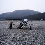
New to the fixed wing community, and to BCP. I'll need to make a trip from Alaska to Alabama after returning from Iraq in late August to early September. I've done all my homework on the AlCan route that gets me down to Dawson City, but after that I've had trouble finding a good route. I hope to do lots of camping along the way and stay clear of the beaten path so to speak. Anyone have any experience with this, suggestions, or warnings.
Brett
1953 Cessna 180
Good route Alaska to Alabama
Fri Nov 14, 2008 12:40 pm

Fri Nov 14, 2008 1:27 pm
All things are possible to him that believes.
Fri Nov 14, 2008 1:33 pm
Have to end up in Enterprise, AL. The trip will be in late summer / early fall of 09. I have a friend that made the same trip in early summer 08. He is actually here in Iraq here with me and we have discussed this at length, but he just wandered his way through. I'm trying to be a little more informed than he was.
Brett
Brett
Mon Nov 17, 2008 9:23 pm
If your trip brings your through North Alabama, then I would recommend two great airports for camping. One is 3M5 (Moontown) that is a 2200' grass strip with lots of nostalgia and local taildraggers. The other is 8A1, Guntersville. Beautiful location surrounded by water. If you come this way please drop us a line. Enjoy your trip.
All things are possible to him that believes.
Tue Nov 18, 2008 3:25 am
The Great Circle route from Dawson Creek to Enterprise takes you over the northeast corner of Montana, across the western corner of North Dakota, and through the center of South Dakota. A deviation to the west would allow you to explore the Missouri Breaks (lots of backcountry strips, and you can stop at Winnifred (9S7) to camp). Check with Centmont (of the sc.org site) for additional details of exploring the Breaks and camping at Winnifred.
You can continue down to Billingings and connect with Kase (also on sc.org) for great ideas on places to explore. Coninuing south, you can stop at Greybull and check out all the remnants of the Hawkins & Powers water bombers. Going southeast from there takes you over enormous open pit coal mines (really hard to imagine manmade holes that big) and you can overfly Mount Rushmore - just use it's CTAF to keep track of the tourist flights. You can camp at Custer State Park (3v0) - an uphill north/south runway with nearby camping. Watch out for the cross winds!
The Great Circle route from 3V0 takes you across Nebraska - a bit of a wasteland - but hydrocub may be able to offer some suggestions of places to visit. Then you're into eastern Kansas, and your route will take you just west of Kansas City: cublite or Steve Johnson (both of sc.org) can give you recommendations for traversing the endless wheat and corn as well as good BBQ restaurant recommendations. They may also be able to help with recommendations for the Show Me State.
Cubchick (sc.org) may have ideas for Arkansas.
This route will take you over Memphis, where you are morally obliged to stop for a day or two to sample bbq. Corky's should be at the top of your list. After taking a triple dose of Lipitor it is only a short flight to Enterprise.
Sounds like you'll have a fun trip.
Eric
- PA12_Pilot offline

- Posts: 236
- Joined: Wed Dec 22, 2004 2:29 pm
- Location: Knoxville
Tue Nov 18, 2008 8:18 am
From Dawson City you can hit either Whitehorse which that time of year is a pretty busy little city or head to Watson Lake. As well, most of all the little towns along the highway in between have airports or at least strips if you need to land because of weather. Watson has fuel and a nice campground at the airport as well some great people at the airport. Town however is about 5 miles or so from the airport. Before leaving there I would check locally for weather and travelling "The Trench" south which is very scenic or jumping over to Fort Nelson which puts you east of the rocks. From there fuel and airports are a bit more frequent. Big & small as you head toward Calgary and the US/CDN border. Make sure to get a CFS (Canadian Flight Suppliment) You can check the towns to see what they have for an airport and services as well contact numbers so that you can call ahead to see if they do actually have fuel and are open. Some of the northern communities will run out of fuel or may just take a weekend off. Sounds like a great adventure. Take care.
- sheephunter offline
- Posts: 92
- Joined: Tue Jun 05, 2007 8:58 am
- Location: Central Ontario
Tue Nov 18, 2008 9:00 am
Lambert's Restaurant in Sikeston, Missouri - "Home of the throwed rolls" They will pick you up at the airport and then take you through the back door to the head of the line. They treat pilots very well.
Gaston's on the White River in Mountain Home, Arkansas. Good strip, Nice cabins, great restaurant, great fishing.
I second Moontown. Great little country strip.
Memphis is fun. Corky's is excellent BBQ, but also consider The Rendezvous.
Have fun!
Gaston's on the White River in Mountain Home, Arkansas. Good strip, Nice cabins, great restaurant, great fishing.
I second Moontown. Great little country strip.
Memphis is fun. Corky's is excellent BBQ, but also consider The Rendezvous.
Have fun!
ceh
Tue Nov 18, 2008 9:34 am
Uh, I'm confused. Dawson City is NOT on the AlCan. In fact, Dawson City really isn't on a line from most of Alaska to AL.
If you take the Alaska Highway route, it would take you from Northway to Whitehorse, to Watson Lake, to Fort Nelson, Fort Saint John, Red Deer, then clear Customs at several places in either MT or ND.
From there down, the sky's the limit, so to speak, and others have offered some good suggestions.
MTV

Tue Nov 18, 2008 10:30 am
I cleared customs in Cut Bank Montana on my way back to Albany Ga. Real good place to clear customs and the airport has a couple of courtesy vehicles at no cost that you can take with you to the Motel, or there are apparently rooms at the airport you can stay at. I assume they are free, but I do not know.
Further south, I would go through here http://www.hotelbeaumontks.com/
You land at the grass strip, taxi through the tiny town and tie down in the Hotels front yard. Kind of neat and you waste no time driving to the airport etc., wake up, eat breakfast and leave. No fuel here though.
You going to mother Rucker to be a traffic pattern I.P.?
Tue Nov 18, 2008 1:11 pm
MTV, you caught me. I misspoke and meant to say that I have read a great deal about the highway route, but haven't gotten a great deal of info about good places to go south or southeast of Fort Nelson (CYXJ). I have been as far as Northway several times. I have studied the highway route and the options and pitfalls along the way (weather reporting gaps). Thank you for your help.
AH-64pilot, I actually am only going for the career course. I am an evil captain. I'm going to try to get out of there as quickly as possible so as not to grow roots.
Everyone else, these are great suggestions. It is making my days go much faster here to rush back to my container house and plan another stop. I really look forward to posting some results of this in the "places I flew today" thread.
PA12_Pilot, your recommendation to try Corky's took me back a couple of years. My wife and I were married in Marion Arkansas on a weekend pass from our two Army training bases. Had Corky's for lunch that day. That makes it a mandatory stop.
Brett
1953 C-180
Tue Nov 18, 2008 3:56 pm
You haven't had BBQ if you haven't been to Interstate BBQ. Little family run BBQ in the hood, close to KMEM. BBQ everything. They even have BBQ nachos. I flew into Memphis KMEM and parked under this huge canopy at Wilson Air Center. The line guys treated me good so I asked if they wanted anything from Interstate and they said "BBQ Nachos". So I ate the "Platter" BBQ pork loin, beef, beef rib, sausage, BBQ spaghetti and baked beans. (man I'm gettin hungry). Got a nachos to go for the lineman and I'll be darned if my plane was still under the canopy when I got back and they were parking Jets in the back 40. Now you know thats good BBQ. Sorry off topic but someone else started it, it's not my fault, really......

If you find yourself in a hole, the first thing to do is stop digging.
Wed Nov 19, 2008 8:39 am
MTV, definitely correct that Dawson City is not on the Alcan. I was figuring UH-60 was coming down from the north and was going to pick up the Yukon River north of Fairbanks and run it on into Dawson City. If so I would then consider heading SE down the Klondike Hwy.to Stewart Crossing then if weather was still good hitting the Pelly River into Faro and then the Glen Campbell Hwy. past Ross River and on into Watson. Presuming he is coming from Anchorage area disregard the above there is no reason to be up in the Dawson City area. You should be as stated previously heading to Whitehorse to clear and then fuel will have you into Watson and like also said once in Fort Nelson the options become unlimited. As well out of Watson if there is a window with good weather you might consider "the trench" which is very scenic taking you down past Scoop Lake - Terminus Mtn. - Fort Ware - MacKenzie - into Prince George - McBride - Lake Loiuse - Banff and out of the mountains at Canmore west of Calgary which is a lot more scenic and adventuresome but you will need the weather. UH-60, you flying the C180 on wheels out of Anchorage area? If so I also have a buddy at the Matanuska Glacier. He has a strip and camping with beautiful views and walking trails out onto the glacier. It's not that far out of Anchorage but if weather dictates, it's not a bad place to hang around. Leo & Rene (L&R Aircraft Service / Big Hangar at Watson) are both great people. Val & Angus have the fuel and aircharter there. The terminal building is very clean and quiet. Angus can provide good advise on how to proceed out of Watson based on weather. Flown floats out of Watson once east and on wheels 3 times all heading to Toronto area so was staying north of your track after Fort Nelson then High Level SE from there. You really do have a lot of options from Fort Nelson depending on the time you have and what you like to do a see. Have fun and keep us posted. Great time of year to be planning. Sounds like fun.
- sheephunter offline
- Posts: 92
- Joined: Tue Jun 05, 2007 8:58 am
- Location: Central Ontario
Wed Nov 19, 2008 9:44 am
The Trench route would really only be a good idea IF the weather was bad on the highway route. This is due to the Trench route going pretty much due south, so longer if going east.
Also, from Watson Lake, I would not necessarily follow the highway the whole distance to Ft Nelson, I'd cut north of the highway route, as it enters the Continental Divide, and follow the lower terrain to the north. Lots of gravel bars there to land on. Lots of BIG rocks along the highway route.
I've cut straight across from Watson Lake direct to Fort Saint John on a stone clear day, but there are very few nice places to land if anything goes wrong.
Once at Ft Saint John, I'd angle as far east as possible, and work my way through the Canadian prairies, as opposed to dropping further south to Cutbank. Cutbank would be quite a ways out of your way. A direct line might cross the Canadian border somewhere in Minnesota or at Pembina, ND, or??
Then again, weather will drive most of those decisions for you. No weather to worry about? (Like that'll happen!!) Punch in Alabama direct to, and follow the pink line...
Great little towns out in the Canadian prairies, nice folks and very accomodating. Gas isn't cheap, but accomodations are.
Coming south the last time, weather forced me south from Ft St John, and got me stuck at Red Deer. I slept on a flight school couch in their offices, and walked the three or four blocks to a restaurant to meals. Was going to set up a tent, and they said "no way--camp in here..."
So, pick yer pleasure. Lots of great places to visit in this here continent.
MTV
Wed Nov 19, 2008 10:10 am
2nd the post above about great camping and scenery at Watson Lake. It may be 5 miles out of town, but it beats anything town has to offer anyway.
Also, some of the WWII emergency strips offer really nice camping and solitude. Prophet River is particularly nice that time of year. It's between Fort Nelson and Fort St John
Also, some of the WWII emergency strips offer really nice camping and solitude. Prophet River is particularly nice that time of year. It's between Fort Nelson and Fort St John
- denalipilot offline


- Posts: 2789
- Joined: Mon Oct 15, 2007 4:53 pm
- Location: Denali
- Aircraft: C-170B+
Wed Nov 19, 2008 10:55 pm
between watson and nelson if you go direct there is an old staging route strip about half way. its big but its quite grown up with trees. you could still get in there with a cub last summer but be careful! its quite remote! there is also an outfitters strip just south east of there by the river it is quite hard to spot and I believe its private but it could be used in a pinch.
I second what MTV said about not following the highway through there unless you like turbulence.
going pelly to faro is good nice wide valley and lots of sandbars. from faro to watson lk you basically follow the highway it gets narrow just before watson and the weather hangs up in there but you can follow the highway through.
Once you get to nelson, go direct to ft st john or grand prairie there is lots of oilfield activity in there many strips.
after that follow the gps you are on the prairies not much for obstacles. have a good trip.
tricycles are for little girls
Sat Nov 22, 2008 8:10 am

- sheephunter offline
- Posts: 92
- Joined: Tue Jun 05, 2007 8:58 am
- Location: Central Ontario
Sat Nov 22, 2008 8:14 am

- sheephunter offline
- Posts: 92
- Joined: Tue Jun 05, 2007 8:58 am
- Location: Central Ontario
Sat Nov 22, 2008 9:25 am
Matanuska Glacier, approx. 105 miles from Anchorage on Glenn Hyw. Going toward Whitehorse. Just up the valley from Palmer.

- sheephunter offline
- Posts: 92
- Joined: Tue Jun 05, 2007 8:58 am
- Location: Central Ontario
Sat Jan 15, 2011 4:22 pm
Re: Good route Alaska to Alabama
UH-60andC-180,
Did you make the trip? I'm looking to do the same in late April early May (weather permitting)...
Any advice is welcome!
Did you make the trip? I'm looking to do the same in late April early May (weather permitting)...
Any advice is welcome!
- Alaskabound offline
- Posts: 138
- Joined: Sun Dec 12, 2010 1:39 pm
- Location: Lake Visnaw (T66) Alaska
Sat Jan 15, 2011 5:01 pm
Re: Good route Alaska to Alabama
I got an invitation to fly wing man to Alaska this August with a man I camped by at Oshkosh who is from Edmonton, Alberta. Who knows when I will get this opportunity again, so Hell Yeah. Plans are to go from here in SD to Edmonton, then Whitehorse to meet a fellow Tundra builder (blue one above mine on the Dream Aircraft home page). Plans from there are in discussion but mostly its open. I'm glad you made this post to bring things up to date. I also would like to share in the experience providing your trip was made. Yet this winter I'm going to hang an MT constant speed prop on my Superior 180 hp and plumb on a 4 into 1 exhaust to see if I can squeeze a little more out of the bird.
My first trip preparation includes my wife letting me hone my plumbing skills for the exhaust system on our new bathroom that she wants. For a copilot she is SO smart.
My first trip preparation includes my wife letting me hone my plumbing skills for the exhaust system on our new bathroom that she wants. For a copilot she is SO smart.
Lynn Sanderson (Dirtstrip) passed away from natural causes in May 2013. He was a great contributor and will be missed dearly.
DISPLAY OPTIONS
Who is online
Users browsing this forum: No registered users and 5 guests
Latest Features
-
Live to Tell
A Minnesota pilot is surprised to learn that the sudden asymmetric drag of an out-of-rig ski can…Read More -
Creators
Working in some of the Yukon's most beautiful and remote environments, photographer Simon Blakesley captures aircraft in…Read More -
Aircraft Ownership and Maintenance
Upgrading to big tires can make a huge difference in backcountry performance, but with those gains come…Read More -
Tales from Yesteryear
In this tale from bush flying yesteryear, Don Cogger signs up to help Atlee Dodge Jr recovery…Read More


Latest Knowledge Base
-
Destinations
A regional guide with ideas for winter camping destinations in California, Nevada, New Mexico, and Arizona.Read More -
Aircraft
Finding an affordable aircraft that can handle the backcountry for $80K or less? A challenge for sure, but with the…Read More -
Aircraft
01.29.2018 - Zane - Updated tire diameter graphic to add 8.50x10 Guide to tires for use in the backcountry and off-airport landing…Read More -
Pilots
12.22.2013 - Initial article format Operating aircraft on skis and negotiating a snow-covered landscape is an entirely unique skillset and environment.…Read More


