As luck always has it, a few weeks before this trip was to start I had a magneto start to go bad on me after nearly 600 hours. I pulled the mag and shipped it off for repair. While it was away, I took care of a few minor maintenance issues that are always present with a 59-year old classic airframe. I prepped the airplane and all the needed supplies for a 4-day flying, camping adventure while I awaited the UPS truck to arrive. Big Brown dropped my gift off Tuesday evening. First thing Wednesday morning we proceeded to install the mag. As all mx actions seem to, it took longer than desired. Feeling the pressure of the incoming wx and the need to get out of town, I slowed down and made sure we were being thorough. By mid-afternoon, the mag had been installed, double-checked and test ran. The rest of the engine compartment items were finalized and the cowl secured. A quick test flight verified everything was working as desired.
My original plan had been to leave on Thursday, but wet, cloudy weather rolling into Western Washington up against the Cascade Mountains led me to needing to get out of town Wednesday. So with the high clouds rolling in, I departed Snohomish, WA’s Harvey Field, S43, and turned to the east, following Hwy 2 over Stevens Pass. The recent rains and snows had brought the numerous waterfalls along the route back to full strength. As I crested the summit, the vibrant bright fall colors of the Leavenworth and Peshastin areas slid under my wings. An hour and a half after taking off, my wheels gently rolled down my crop duster buddy’s strip in Moses Lake, WA. My partner for the trip, my brother, was waiting for me. Mike is the third pilot in the family. He earned his private license less than a year ago. I landed feeling much more relaxed after a stressful few days wondering if I would have to end up driving on this trip.


Thursday morning presented itself with high clouds, but no true weather concern for our 445nm run south to Dead Cow Lake. Our flight plan took us from Moses Lake to Pendleton OR, KPDT. Strong winds aloft from the south kept these two farm boys happy to be flying low across the farmlands of Central Washington. Soon the Snake River slid below us as we crossed into the dry-land farming area that would lead us to our first fuel stop. The rolling wheat fields and desert sagebrush draws were providing us lots of deer to observe. Of course, it was during hunting season, so all the bucks were tucked away in their hideouts. We really didn’t need fuel at PDT, but this route didn’t have many fuel options and due to our weight, we could only carry 30 of my maximum 37 gallons to remain below gross. Pendleton sits on a hill just west of this famous rodeo town. This former WWII training base has connections back to the Doolittle Raiders of the 17th Bombardment Group.
Less than 20 minutes after landing we were airborne again for our second leg. An early 90-degree left turn from our runway 29 departure had us on course to pickup Hwy 395 that we would follow through Eastern Oregon to John Day and Burns. The seventy-seven miles to John Day introduced us to the ever slightly rising terrain of the high mountain plateaus, pine trees and prime fishing rivers that make this part of Oregon a sportsman’s favorite. Immediately south of John Day, the scars from forest fires along Strawberry Mountain the last few seasons were evident. Thankfully, they were actively logging the areas, salvaging much of the wood and reducing future fuel loads as well as providing the local economy good jobs. We continued to only see 75-80KTS ground speeds as the south winds lived up to the daily forecast. About the midpoint of the leg was a private 5,000’ paved strip at the “Ponderosa Ranch”. This Ponderosa was a 120,000-acre private ranch that for approx. the last 20 years has served as a high-end dude ranch, with its own reversible 18-hole golf course, par 3 course, shooting clays and numerous other activities. The ranch also still runs approx. 5,000 head of cattle. Another 122 miles of similar terrain led us into Burns Oregon and the BNO airport. Located 7 miles east of the small rural town, recently made infamous by the standoff between the federal government and ranchers and activist from several western states, the airport offers little more than the 100LL we needed.


Airborne for our third and longest leg of the day had us headed mostly directly toward Loveland, NV. Immediately south of Burns we climbed out over the Malheur Wildlife Refuge. Created in 1908 by President T. Roosevelt, 58 species of mammals and 320 species of birds call these 293 square miles home. From a few thousand feet above, we spotted several flocks of birds, large and small. The skies ahead we quickly clearing, providing beautiful views, just as forcasted. With terrain in Nevada often rising to over 9,000’ MSL, we were fortunate to be traveling parallel to most of the terrain. One of those large terrain features is the Steen Mountains. When I was flying F-15C’s out of Mt Home AFB, we flew a low level that approached the sloping west flanks, peaking out between 7,500 and 9,000 feet. As we approached the top we would rapidly roll into 135 degrees of bank and aggressively pull down the backside, which featured a very steep drop back down to the high desert floor. If one has never flown thru this part of the country, they really can’t realize how BIG this part of the country is. Near the end of this leg my brother commented, “We only had one dry lakebed to go before our 2+40 hour leg was complete.” Unfortunately, he failed to realize this lakebed, Black Rock – home to the famous Burning Man Festival, was over 40 miles long. Eventually the lake passed behind us, leaving a few small hills between our destination and us.


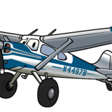
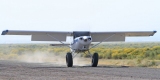
Derby Field, KLOL, at Lovelock, NV was home to a WWII training base. A very neat little photographic museum next to the fuel pumps documented its proud history. As we pulled up to the fuel ramp we observed four different C-180/185s. I recognized one of the birds as a fellow BackCountryPilot.Org member. Then I heard my name being called, only to turn around and see a fellow USAF Fighter Pilot friend of mine. He flew his 180 in from Tucson, AZ for the event. Fuel was not available on the lakebed, so we uploaded about 25 gallons for the 40-mile run westward to HSF. As we lifted off of LOL, we faced a ridge 5 miles in front of us with tops over 4,000 above the airport elevation. As we started our slow climb out at a DA of over 6,000 feet, I spotted a small dry lake that I suspected would be producing some rising air. Sure enough, as we passed over the north end, the VVI quickly confirmed what we were feeling in our seats. A left turn took us down the lake until the free lift started to wane. An immediate hard 180 put us back into the rising air. By the time we hit the north end again, we had enough altitude to point our nose directly towards the ridge and the fun that was soon to be ours. Three perpendicular ridgelines slid beneath us presenting us with beautiful views of Pyramid Lake and the unique geological formations at its northern shores that the lake derives its name from. We had been monitoring the CTAF for Dead Cow Lake and were building the mental picture of the traffic as we rounded the northern end of the last terrain between fun and us. Dead Cow Lake is over 5 miles across and even knowing where to look, it wasn’t easy to see the over 100 airplanes and numerous RV’s and vehicles that had already arrived. We flew south of the camping area, watching and listening for an opening in the pattern. We joined the right downwind for a landing to the SE. With my brother having never experienced a landing environment such as a dry lakebed, I explained the visual difficulties, lack of depth perception, and lack of visibility due to dust and other factors and how we would deal with them. A 30-flap approach with 5mph higher than normal airspeed and a few hundred RPM’s allowed us to have a gentle descent rate as we approach the widely spaced cones marking the runway area. Once below 20 feet it wasn’t that difficult to determine our height above the surface and soon our three wheels touch the white dusty surface. We decelerated, turn right and slowly taxied towards the randomly parked aircraft. It was time to set up camp, enjoy a cold one and start meeting new friends and admiring airplanes.
End of Part 1