Backcountry Pilot • Is this an old WW2 emer strip on Ore hwy 20? (pic)

Is this an old WW2 emer strip on Ore hwy 20? (pic)

Discuss your knowledge of airports and off-airport strips. Help inform other pilots of status, warnings, noise abatement, and closure endangerment. See also: http://www.shortfield.com
7 postsPage 1 of 1

Is this an old WW2 emer strip on Ore hwy 20? (pic)

I've wanted to ask this for a while. Kinda looks like it, and if it was, does anybody know the name of it. Any history on it,etc.?
Location: 18NM West of Riley Oregon, 16NM East of Hampton Oregon, 6NM NE of Glass Butte, on the North side of Ore Hwy 20. Looks like 2300 ft long X 130ft wide.

I know, I know...History is not everyone's bag, and it looks like the sage is back, so not of much use to BCP members.
Just wondering...Thanks. Image
Photo Credit: G-Earth
Mods: please move, if this is not the place. :oops:
BladeRunner offline
User avatar
Posts: 133
Joined: Wed Feb 05, 2014 12:46 pm
Location: Willamette Valley, Oregon

Re: Is this an old WW2 emer strip on Ore hwy 20? (pic)

The Army built a few emergency strips in Oregon during the war, but they were all big enough to land a B 24 on, this looks about 1/2 size or less. Rome state and Alkali lake state are 2 former emergency strips left over from the war.
Dale Moul offline
User avatar
Posts: 523
Joined: Fri Dec 21, 2007 12:37 pm
Location: Boise Idaho
Dale
Gravity Strikes Again.

Re: Is this an old WW2 emer strip on Ore hwy 20? (pic)

History not everyone's bag? You haven't found the Giant Concrete Arrow thread have you? Lot's of airway history there. Many of the old airway beacons used by the airmail guys also had emergency landing strips built along the routes. I'll go back and see if this correlates to one of the beacons.

Edit: Does NOT correlate to an airway beacon location.
svanarts offline
User avatar
Posts: 1393
Joined: Sun Aug 10, 2008 3:18 pm
Location: Modesto, CA
Aircraft: 7AC (65HP) Aeronca Champ (borrowed horse)
Six Chuter Skye Ryder Powered Parachute

Re: Is this an old WW2 emer strip on Ore hwy 20? (pic)

Dale: Rodger that, on the Rome and Alk State airports in Eastern Oregon.
Scott/Svanarts, I thought the concrete arrows were to direct the aliens toward Roswell NM.
Image
I've seen a few posts here at BCP that basically raze guys that post stuff about airports that are not usable, and was trying to avoid the same coming to me. ( case in point, Tunnel Meadows Ca. )

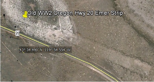
I used a G-earth measuring tool to get the dimensions. Sounds wide enough, not sure how much length a B-17, 24, 25, 26, or 29, would take on a normal day. What about a Fighter E-strip? Aux training strip for Stearmans? Anyways, it sure is interesting to speculate on. I guess it could have been built in the early years of the war ( therefore shorter ), or even part of the air-mail system. Maybe an E-strip for smaller aircraft only? With the way we were expecting the "land of the rising sun" to invade the West coast, who knows :?: . Maybe just an early BLM/FS strip similar the other USFS strips for wildland fire purposes. I think back in the 1950's the policy was to have fires out in a day ( yeah, sure...), therefore many, many small strips. Doesn't cost much to plow up some sage and therefore have another fire asset available in case you need it. Closest airport would have been Burns or Millican and Brothers back then. And of course, we have all seen how short a FS strip can be.

Anybody else care to speculate? Share your opinion and lets all learn something.
BladeRunner offline
User avatar
Posts: 133
Joined: Wed Feb 05, 2014 12:46 pm
Location: Willamette Valley, Oregon

Re: Is this an old WW2 emer strip on Ore hwy 20? (pic)

It is pretty close to the Fort Rock BLM strip, that is not on sectionals or published in any way. So my guess is that it's probably an old BLM strip or possibly a ranchers strip.
chosstronaut offline
User avatar
Posts: 543
Joined: Thu Apr 05, 2012 5:07 pm
Location: Corvallis
FindMeSpot URL: http://share.findmespot.com/shared/face ... 9a7NU2UfGC
Aircraft: Savannah
Tyler Adams, aka Chosstronaut, perished in a mid-air collision October 12, 2014. He was an enthusiastic and beloved contributor and he will be missed greatly.

Re: Is this an old WW2 emer strip on Ore hwy 20? (pic)

In case you don't know of this site, it's a pretty cool resource for abandoned strips and history. You might be able to find something here, or contact them and see what they know.

I find this stuff interesting and often wonder which one of these abandoned strips might have potential to be revived.

http://www.airfields-freeman.com
Grassstrippilot offline
Knowledge Base Author
User avatar
Posts: 3536
Joined: Wed May 31, 2006 6:17 am
Location: Syracuse, UT
FindMeSpot URL: https://share.garmin.com/WolfAdventures
Aircraft: Cessna 205

Re: Is this an old WW2 emer strip on Ore hwy 20? (pic)

A very large majority of WW2 training, auxiliary, and emergency strips are laid out as triangles. This is the reason that you see so many municipal and regional airports that still have that triangle somewhere in the runway layout, even though runways were extended in different directions over the years.

I believe most of the WW2 triangles were made up of runways that were about 3500 feet in length. This is enough to take off and land a B-17, but not when it's heavy. Apparently it's a kite when empty. The B-24 should need far more real estate than the B-17, whether empty or heavy. The famous "Davis wing" on the '24 was one of the early "natural laminar flow" airfoils, coupled with a high aspect ratio. Designed for cruise at altitude with very little compromise elsewhere.

The Freeman airfields website is an absolute gem. Anyone who loves aircraft history needs to spend some quality time there.
EZFlap offline
User avatar
Posts: 2226
Joined: Thu Aug 13, 2009 9:21 am
.

DISPLAY OPTIONS

7 postsPage 1 of 1

Who is online

Users browsing this forum: No registered users and 0 guests

Latest Features

Latest Knowledge Base