One of the things I've tried to do on shortfield.com is to encourage the documentation (in the airstrip database) of these types of runways so that we know where they are and what their current status is. I figure its a good thing for us to know about them (even if they are currently closed) and to collect information (photos, pireps, videos, etc.) so we have documentation of their former and current use.
I hear most of the strips on the John Day are in the same situation and I fear they will also be lost if we don't get on it.
This is the best place for backcountry flying conversations, but specific airstrip information gets lost and spread out in the various forum posts. I encourage anyone who uses these types of airstrips to post information at shortfield.com so we have all the airstrip information in a central location.
I'll add these strips to the database and I will also create a new article/section on threatened airstrips and would like to hear any news you might have so we can keep tabs on meetings, etc. If we know in advance, we can get people organized and show-up and weigh-in on the issue.
Let me know what you think.
Owyhee strips "X'ed" out..
Wed Oct 27, 2010 12:58 pm
- chrisg offline
- Airstrip Database Manager
- Posts: 220
- Joined: Tue Jan 01, 2008 9:04 pm
- Location: Coeur d'Alene, Idaho
Chris
http://www.shortfield.com - Backcountry Airstrip Database
https://discord.gg/HNHKeDE - Groundfall - Bush Flying Video Game
http://www.shortfield.com - Backcountry Airstrip Database
https://discord.gg/HNHKeDE - Groundfall - Bush Flying Video Game
Wed Oct 27, 2010 1:04 pm
Re: Owyhee strips "X'ed" out..
I think it would be good relations for anyone who feels so inclined to send a message to the Shoshone Paiute tribes congratulating them on recognizing the importance of general aviation to remote areas of the country.
Tom
Tom
Wed Oct 27, 2010 2:31 pm
Re: Owyhee strips "X'ed" out..
Well, they could have plowed it up and made it unavailable...it is their land after all...instead they reoriented the runway to the prevailing winds and are putting in a very usable airport.
I don't know what you find in your area but keeping small airports in operation is a continuing battle and I am all for giving an attaboy to those who seem to recognize general aviation is useful.
Do nothing if it pleases you, it was just a suggestion.
TD
I don't know what you find in your area but keeping small airports in operation is a continuing battle and I am all for giving an attaboy to those who seem to recognize general aviation is useful.
Do nothing if it pleases you, it was just a suggestion.
TD
Wed Oct 27, 2010 6:16 pm
Re: Owyhee strips "X'ed" out..
DavidB. wrote:Oregon Natural Desert Association is responsible for it.
Responsible for which? The conversation has kind of gotten confusing about which strip/airport we are talking about.
- onceAndFutr_alaskaflyer offline
- Posts: 1319
- Joined: Sun Apr 23, 2006 4:23 pm
- Location: Keweenaw Peninsula, Michigan and Carson Valley, Nevada
Wed Oct 27, 2010 10:31 pm
Re: Owyhee strips "X'ed" out..
once&futr_alaskaflyer wrote:DavidB. wrote:Oregon Natural Desert Association is responsible for it.
Responsible for which? The conversation has kind of gotten confusing about which strip/airport we are talking about.
The strips on the Owyhee. I looked through my saved emails, but think I got rid of the new letter from them looking for the donation of time with a tractor to remove several airstrips they thought were too close to the study area. They have been doing stuff like this to the dirt bikers for a few years, now they are going after airstrips too. A bunch of the trails around Bend have been ruined by their tire spikes and relocated barbed wire. At least they x'd out these strips. I do not know for sure it was them, or if they pressured the BLM or land owner to remove the strip, but it was on their agenda a few months ago.

Mon Mar 28, 2011 11:41 am
Re: Owyhee strips "X'ed" out..
Any more news on this?
- chrisg offline
- Airstrip Database Manager
- Posts: 220
- Joined: Tue Jan 01, 2008 9:04 pm
- Location: Coeur d'Alene, Idaho
Chris
http://www.shortfield.com - Backcountry Airstrip Database
https://discord.gg/HNHKeDE - Groundfall - Bush Flying Video Game
http://www.shortfield.com - Backcountry Airstrip Database
https://discord.gg/HNHKeDE - Groundfall - Bush Flying Video Game
Sun Oct 09, 2011 9:57 am
Re: Owyhee strips "X'ed" out..
DavidB. wrote:There is also a down with ODNA Facebook page.
I can't find their page. Does it still exist? And what does the ODNA abbreviation stand for? (hope that's not a dumb question. But I did try Googling it, but nothing came up).


Sun Oct 09, 2011 10:47 am
Re: Owyhee strips "X'ed" out..
drifter wrote:The lat./long. for the two landing areas referred to in my initial posting are:
1. What the topo maps call Jackson Hole: 43°11'25.08"N; 117°38'48.03"W
2. What I call "Deserted Ranch": 43°12'24.37"N; 117°36'5.83"W
Phil
I just purchased the latest maps from the Vale BLM Office and I'm finding some interesting stuff here. More on that later when I get my thoughts straight
The first strip mentioned above (Jackson Hole) is for sure with in the "Wilderness Study Area".
The second one "Deserted Ranch" is actually called "Hole in the Ground Ranch". On the map I have that I just purchased from the Vale BLM office show's that ranch being on BLM land. But, there is no airstrip shown on the map. There is an existing road that you can drive, bike or ATV in on to the ranch. I was just out at Birch Creek Ranch on Saturday. I bummed I didn't think to look at the map to go check out the Hole In the Ground Ranch too now. Next time I will. Oh..... one more thing about this Ranch. It is inside the Blue Dotted Area (OHV Limited to Designated Roads). Which means that "motorized vehicle travel is limited strictly to only roads displayed on the map".
Anyway........ the reason why I bring this up, is that I've been riding a Yamaha Rhino around in the Owyhee's and this has sparked up my interest again.
Sun Oct 09, 2011 11:28 am
Re: Owyhee strips "X'ed" out..
I spent my Saturday exploring the Birch Creek Historical Ranch area on a Yamaha Rhino. This ranch in owned by the BLM and is displayed as being on BLM land along the Ohyee River. In fact, BLM owns the land for about 2-3 miles south of the ranch along the river (on both sides) and about 3-5 miles to the north (on both sides). This ranch (Birch Creek Historical Ranch) also appears to have an airstrip on the north end of the ranch. It appears the have been kept watered and mowed. So I wonder if the BLM is using this airstrip for themselves??
And across the Ohyhee River to the north of Birch Creek Historical Ranch is what I believe in known as "No Shit South" airstrip which is Xed out and lot's of big rocks tossed on the runway. It is located on BLM land, NOT the Wilderness Study Area or Wilderness land. There are also numerous trails and roads that are in this same area of the OSS airstrip. I spoke with a hunter that was staying in the campground at the Birch Creek Ranch and he said that ATVers and even the BLM themselves ride up and down those trails/roads by the OSS airstrip all the time. So why close an airstrip that is right next to existing trails and roads that are still being used by ATVers and even the BLM??? I dunno
Another airstrip of interest to some is what may be called "No Shit North". The map that I purchased from the BLM office (like I mentioned earlier) shows that airstrip as possible being owned by the State of Oregon and/or Other Federal agency. OSN is NOT inside a "Wilderness Study Area", "Wilderness" and/or "BLM' land. OSN is also OUTSIDE of the blue dotted area (OHV Limited to Designated Roads). Which means that "motorized vehicle travel is limited strictly to only roads displayed on the map". I did ask the people at the Vale BLM office about this strip (OSN) and they did tell me it is "CLOSED". But, I didn't look at the map until I got home. Now it would be very interesting to get the down right facts form somebody about this strip and all the other strips along the Owyhee.
On another note I did have a fantastic day exploring the Birch Creek area on ground!! What an amazing area! To me, it rivals the Grand Canyon to a certain degree. Pretty remote with very little people around. I'm thinking late spring, early summer would be pretty epic to see this area! Actually, the whole Owyhee area from Wild Horse Reservoir in Northern Nev. all the way down the the Snake river would be just awesome to see form the air, raft, and by 4x4/ATV's.
And across the Ohyhee River to the north of Birch Creek Historical Ranch is what I believe in known as "No Shit South" airstrip which is Xed out and lot's of big rocks tossed on the runway. It is located on BLM land, NOT the Wilderness Study Area or Wilderness land. There are also numerous trails and roads that are in this same area of the OSS airstrip. I spoke with a hunter that was staying in the campground at the Birch Creek Ranch and he said that ATVers and even the BLM themselves ride up and down those trails/roads by the OSS airstrip all the time. So why close an airstrip that is right next to existing trails and roads that are still being used by ATVers and even the BLM??? I dunno
Another airstrip of interest to some is what may be called "No Shit North". The map that I purchased from the BLM office (like I mentioned earlier) shows that airstrip as possible being owned by the State of Oregon and/or Other Federal agency. OSN is NOT inside a "Wilderness Study Area", "Wilderness" and/or "BLM' land. OSN is also OUTSIDE of the blue dotted area (OHV Limited to Designated Roads). Which means that "motorized vehicle travel is limited strictly to only roads displayed on the map". I did ask the people at the Vale BLM office about this strip (OSN) and they did tell me it is "CLOSED". But, I didn't look at the map until I got home. Now it would be very interesting to get the down right facts form somebody about this strip and all the other strips along the Owyhee.
On another note
Sun Oct 09, 2011 7:31 pm
Re: Owyhee strips "X'ed" out..
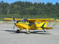
Here's the possible airstrip that is located at the Birch Creek Historical Ranch. It's actually called The Pinnacle Ranch Airstrip (according to Google Earth and a Google search).
Looking to the south (note the trees at the end)

Looking to the north.

The strip is in excellent shape and obviously well maintained, even kept watered and mowed. It's a short runway (I didn't think to measure it), but plenty wide. But it does have some trees on the south end of the strip. I believe the BLM owns this strip. So that means you and I are paying for this . (which is fine, we're paying for a lot of airstrips we don't get to use
  ). The one thing I didn't see or missed is a windsock. So I'm not even sure if a plane even lands here. But why else would the BLM water and mow this strip of land? The mower is sitting under a shelter (looked fairly new, too). And I assume the tractor is inside the fairly new barn and even a huge fuel tank by the toilets
But, I wonder what it would take to get it open to the public? It would be an awesome place to fly into! Already has established camp sites and toilets. Great hunting, fishing, and hiking trails in an very scenic part of the Owyhee River. Heck, they allow dirt bikes, atv's, cars and trucks with trailers in this area, why not airplanes?? Maybe this is something the RAF might be interested in if they have not already?
Just checked Shortfield.com: http://www.shortfield.com/index.php?option=com_jumi&fileid=5&Itemid=125&snum=19480.3*A&initlat=43.22904555556&initlong=-117.49683111111
Looking to the south (note the trees at the end)
Looking to the north.
The strip is in excellent shape and obviously well maintained, even kept watered and mowed. It's a short runway (I didn't think to measure it), but plenty wide. But it does have some trees on the south end of the strip. I believe the BLM owns this strip. So that means you and I are paying for this
But, I wonder what it would take to get it open to the public? It would be an awesome place to fly into! Already has established camp sites and toilets. Great hunting, fishing, and hiking trails in an very scenic part of the Owyhee River. Heck, they allow dirt bikes, atv's, cars and trucks with trailers in this area, why not airplanes?? Maybe this is something the RAF might be interested in if they have not already?
Just checked Shortfield.com: http://www.shortfield.com/index.php?option=com_jumi&fileid=5&Itemid=125&snum=19480.3*A&initlat=43.22904555556&initlong=-117.49683111111
Sun Oct 09, 2011 7:54 pm
Re: Owyhee strips "X'ed" out..
58Skylane wrote:DavidB. wrote:There is also a down with ODNA Facebook page.
I can't find their page. Does it still exist? And what does the ODNA abbreviation stand for? (hope that's not a dumb question. But I did try Googling it, but nothing came up).
ODNA stands for Oregon Natural Desert Association. They are a fringe group of the Seira Club and ran by one of the founders of earth first, Asante Riverwind. They are out of Bend Oregon. They are a nasty bunch of tree huggers. Not sure what they are doing now, or what the staus of the "Down with ODNA" site is. Last I heard a pipe line company paid them 17,000,000 to stop bugging them and that they were now going to spend the money going after the ranchers and loggers in Harney County Oregon (Burns area). Thats who ran the "Down with ODNA" site. They are all probably to broke and beaten down to fight now. I decided to stop fighting them, it get my blood pressure to high and makes me want to start drinking. It is much easier to just retreat to my hangar and work on my Champ.
Thu Oct 27, 2011 7:28 pm
Re: Owyhee strips "X'ed" out..
This is kind of encouraging!
From the Nov. 2011 IAA "The Flyline" newsletter. http://www.idahoaviation.com/images/usercontent/November%202011%20web.pdf
From the Nov. 2011 IAA "The Flyline" newsletter. http://www.idahoaviation.com/images/usercontent/November%202011%20web.pdf
Closure of Owyhee River Airstrips by BLM
DuWaine Emmons
The flying community has officially lost the use of several
superb backcountry airstrips along the Owyhee River
drainage in Eastern Oregon. Those strips are upstream of
Owyhee Reservoir State Airport (Pelican Point) 28U and
downstream of Rome Service Airport 0OR6. This was
discovered on October 9th by a local SkyPark pilot flying to
Pinnacle Ranch Airstrip near Birch Creek Ranch.
After a few calls to the Idaho Aviation Association (IAA),
Oregon Pilots Association (OPA) and the Recreational
Aviation Foundation (RAF) and emails to the Director of
BLM, Oregon and the Director of the Oregon Department of
Aviation, a meeting was scheduled with the Director of the
Vale BLM office. This meeting was held on October 17th.
Four members of the IAA met with the Director of Vale
BLM. The meeting was very informative and cordial. It
was discovered that the airstrips along the Owyhee River
were closed by federal law in the Wild and Scenic River Act
of 1984. Further, a BLM Management Plan dated in 1993
specifically named the airstrips along the river as “closed to allaircraft”.
In 2002, Southeast Oregon Resource Management
Plan reaffirmed the closures.
The Vale BLM office ordered for the Pinnacle Ranch Airstrip
to be closed by placing a white X in the center of the 2,600’
airstrip and the placement of rocks/boulders along the length
of the strip. This creates a significant hazard to any aircraft
trying to make an emergency landing. Pinnacle Ranch
has been used continuously over 20-years by pilots from
Idaho, Oregon, and those traveling to and from Nevada and
California. Pinnacle Ranch has been identified on USAF
training maps forever.
The OPA, IAA and RAF are trying to research the history of
Pinnacle Ranch along with Morrison Ranch, Jackson Hole
and Bogus Creek along the Owyhee River in Oregon. (If you
have knowledge of any of these strips, please contact Bill
Miller with the IAA.)
The positive news from all of this is the Director of the Vale
BLM is having his staff remove the rocks/boulders from the
strip to allow emergency landings if required. Please note
violating a closure within the Wild and Scenic River Act is a
Class B misdemeanor. There is a maximum fine of $500 and/
or 6 months in jail.
Currently, the OPA, RAF and IAA are researching the
regulations and looking at options to try and have the
Pinnacle Ranch and other airstrips reopened. As this a good
reason to join all three organizations and maintain a good
standing, they are working for you! I’ll keep you posted as
details evolve.
Wed Nov 23, 2011 4:45 pm
Wed Nov 23, 2011 5:59 pm
Re: Owyhee strips "X'ed" out..
Throttle Pusher wrote:"Wilderness Study Area" Is just another way for the granola eaters to give us the finger.
Another two strip gone into history.That just Sucks!!!

The tree huggers have tried to pull that Wilderness Study Area crap here in NW Wyoming... The whole NFS office is entrenched with those " STAY OUT " assholes..... Case in point... the Wyoming range is a VERY remote area with steep slopes and hostile terrain... It is next to impossible to even hike in the area. So...... A few years back a local helicopter company set out to use the area for heli skiing. They didn't bother anyone,, it is so far from people even the noise is not an issue, the place is so remote there is no way anyone can access it during the winter unless in a helicopter..... And.. once the snow melts there is NO sign of anyone ever being there as their ski tracks dissappear with the spring thaw.................... So here comes the treehuggers and manage to shut down the heli operation based on perceived conflicts and the FS rolled over and caved in.

There were other places in the forest around here where they posted their " Wilderness Study Area " signs to keep out us snowmobilers.... We confronted them on their motives and their response was .. we are protecting the winter ranging moose population..... Keep in mind these signs were planted at over 10,000 feetMSL on ridgelines, in very rocky, windy areas... Even a first grader knows all the moose are on the valley floor 4000 lower hanging out in the willows for habitat.... Those huggers put up a good fight till we requested documentation on any "official" studies to confirm the moose, that didn't exist up that high would be stressed by human presence..... They finally caved in and admitted their request for the "study" area was based on some fanatical biologist who had a dream....... Those signs were then used for traction for any snowmobiler in the area.
 . In fact their theory was so flawed they never even tried to enforce the action they wanted to force down our throats............................. YMMV....
Now, for putting boulders on a grass airstrip to prevent planes from landing.. That's all fun and games till someone dies from hitting one.. Then the lawyers will sue the crap out of every agency within 1000 miles that had even a hint of involvement... IMHO... That deadly action cuts both ways ya know..
Last edited by Stol on Wed Nov 23, 2011 6:36 pm, edited 1 time in total.

Ben Haas
www.haaspowerair.com
www.haaspowerair.com
Wed Nov 23, 2011 6:15 pm
Re: Owyhee strips "X'ed" out..
Stol wrote:
Now, for putting boulders on a grass airstrip to prevent planes form landing.. That's all fun and games till someone dies from hitting one.. Then the lawyers will sue the crap out of every agency within 1000 miles that had even a hint of involvement... IMHO... That deadly action cuts both ways ya know..
Actually now that you brought that up and my fault for not adding that information in. The rocks on the airstrip across the river and downstream from the Pinnacle Ranch have been removed recently just for the reason you mentioned Ben. The strip is supposedly clear of rocks but can only be used for and "Emergency"
Bill sounded optimistic about these airstrips being reopened someday. He's just hoping to get more support from pilots that want these strips open and willing to use them on a regular basis.
Wed Nov 23, 2011 6:17 pm
Re: Owyhee strips "X'ed" out..
Zane maybe you can merge these.
BLM trying to close ALL! BLM strips in Oregon
viewtopic.php?f=2&t=8827
Another good reason for bushwheels.
BLM trying to close ALL! BLM strips in Oregon
viewtopic.php?f=2&t=8827
Another good reason for bushwheels.
- OregonMaule offline

- Posts: 6977
- Joined: Fri Sep 01, 2006 9:44 pm
- Location: Orygun
My SPOT page
"They who can give up essential liberty to obtain a little temporary safety, deserve neither liberty nor safety". Ben Franklin
http://en.wikiquote.org/wiki/Benjamin_Franklin
"They who can give up essential liberty to obtain a little temporary safety, deserve neither liberty nor safety". Ben Franklin
http://en.wikiquote.org/wiki/Benjamin_Franklin
DISPLAY OPTIONS
Who is online
Users browsing this forum: No registered users and 0 guests
Latest Features
-
Live to Tell
A Minnesota pilot is surprised to learn that the sudden asymmetric drag of an out-of-rig ski can…Read More -
Creators
Working in some of the Yukon's most beautiful and remote environments, photographer Simon Blakesley captures aircraft in…Read More -
Aircraft Ownership and Maintenance
Upgrading to big tires can make a huge difference in backcountry performance, but with those gains come…Read More -
Tales from Yesteryear
In this tale from bush flying yesteryear, Don Cogger signs up to help Atlee Dodge Jr recovery…Read More


Latest Knowledge Base
-
Destinations
A regional guide with ideas for winter camping destinations in California, Nevada, New Mexico, and Arizona.Read More -
Aircraft
Finding an affordable aircraft that can handle the backcountry for $80K or less? A challenge for sure, but with the…Read More -
Aircraft
01.29.2018 - Zane - Updated tire diameter graphic to add 8.50x10 Guide to tires for use in the backcountry and off-airport landing…Read More -
Pilots
12.22.2013 - Initial article format Operating aircraft on skis and negotiating a snow-covered landscape is an entirely unique skillset and environment.…Read More


