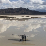
Took a friend flying today. Left Sedona for a killer b'fast a LaPasada in Winslow(which I believe is the last of the Lindburg airports), probably the best b'fast stop in northern Az..
Went over to St. Johns for some $2.75/gal Avgas(Saweeet). Pretty cool spot. Besides the relativey cheap gas, they have a nice picnic area, camping is allowed on field, and a courtesy car is available to go to town for some good food(I hear) at local restaurants, or whatever.
Headed south out of there(kinda) for a ways, then saw a drainage that ran into the Salt River, and into Roosevelt Lake. It started up on the Apache Reservation near a town called Cebecue, or something like that. Some really nice canyon flying down there, particularly once you hit the Salt.
So, anyways, my question for the Az. guys is: About 10 miles before I got to Roosevelt, I saw what looked like, must of been an airstrip at one time, and still should be, it was on the left side flying down the river. Has anyone landed there? Does it have a name? Looks like probably 7-800' with a little uphill towards the down river. A little narrow, but defineately doable.
So, lets here it guys. Whadya know about it?
Thanks Gary
Question for the Az. Backcountry Specialist
Tue Jan 13, 2009 6:42 pm
- shortfielder offline
- Posts: 2350
- Joined: Sun Mar 05, 2006 7:14 pm
- Location: Durango, Colorado
- FindMeSpot URL: http://share.findmespot.com/shared/face ... D263l9HKFb
If you want to go up, pull back on the controls. If you want to go down, pull back farther.
My SPOT page
My SPOT page
Wed Jan 14, 2009 11:26 pm
Shortfielder,
That may be on the reservation. I know several of the ranches around that part of the world, I can make a couple of calls and see what those folks know.
Jim
That may be on the reservation. I know several of the ranches around that part of the world, I can make a couple of calls and see what those folks know.
Jim
- flyin puncher offline

- Posts: 42
- Joined: Wed Apr 09, 2008 7:58 pm
- Location: Las Cruces, NM (LRU)
In the market for a plane.
Thu Jan 15, 2009 12:02 am
Hey Jim
I was talking to a friend tonight that has rafted down that river, and walked the strip. He said that area was geiser flats, or something like that. He said you could drive across some ranch land, so I thought that it probably wasn't on any reservation, but that's only a guess.
Thanks for the response, and any effort to find out more.
Gary
- shortfielder offline
- Posts: 2350
- Joined: Sun Mar 05, 2006 7:14 pm
- Location: Durango, Colorado
- FindMeSpot URL: http://share.findmespot.com/shared/face ... D263l9HKFb
If you want to go up, pull back on the controls. If you want to go down, pull back farther.
My SPOT page
My SPOT page
Thu Jan 15, 2009 10:18 am
Gary, I was just speculating on the distance. I have to be over there next week, so I will see what I can find out. I do some work on the Haystack Butte Ranch and the Flying H, which are across the river from each other at about the distance that you estimated.
Jim
Jim
- flyin puncher offline
- Posts: 42
- Joined: Wed Apr 09, 2008 7:58 pm
- Location: Las Cruces, NM (LRU)
In the market for a plane.
Thu Jan 15, 2009 1:17 pm
Jim
I will see if I can get you exact coordinates. My friendsaid that it used to be on the old charts.
Gary
I will see if I can get you exact coordinates. My friendsaid that it used to be on the old charts.
Gary
- shortfielder offline
- Posts: 2350
- Joined: Sun Mar 05, 2006 7:14 pm
- Location: Durango, Colorado
- FindMeSpot URL: http://share.findmespot.com/shared/face ... D263l9HKFb
If you want to go up, pull back on the controls. If you want to go down, pull back farther.
My SPOT page
My SPOT page
Thu Jan 15, 2009 7:21 pm
Hey Jim
I tried to find it on google, and in my gazetter, with no luck. I have some coordinates that willl get you pretty close. 110.45'W, 33.40' N. It's a pretty cool flight, even if you don't find it. It is pretty obvious, I doubt that you can miss it from the air. There is a road to, and through it. Pretty close to the river. If you plan to land, figure for soft sand,
Gary
- shortfielder offline
- Posts: 2350
- Joined: Sun Mar 05, 2006 7:14 pm
- Location: Durango, Colorado
- FindMeSpot URL: http://share.findmespot.com/shared/face ... D263l9HKFb
If you want to go up, pull back on the controls. If you want to go down, pull back farther.
My SPOT page
My SPOT page
Thu Jan 15, 2009 7:33 pm
I am jealous Gary, I think I am going to forget how to fly my 180. Sounds like you had a good trip.
Cheers,
Dave
Cheers,
Dave
- wagonwrench offline
- Posts: 107
- Joined: Sat Sep 15, 2007 12:40 pm
- Location: Grangeville, ID
Thu Jan 15, 2009 8:13 pm
Hey Dave
Ya gotte get down here. Been some real good flyin lately, Last couple months. Just got back from Az. and doing my annual. That went well, and did some good flyin while I was down there.
Got some good videos on the way back. If it comes out good I'll send it to ya, and see if it will getcha in the mood, anddown here.
Later G
- shortfielder offline
- Posts: 2350
- Joined: Sun Mar 05, 2006 7:14 pm
- Location: Durango, Colorado
- FindMeSpot URL: http://share.findmespot.com/shared/face ... D263l9HKFb
If you want to go up, pull back on the controls. If you want to go down, pull back farther.
My SPOT page
My SPOT page
Thu Jan 15, 2009 8:52 pm
Hi Gary,
A specialist I am not... but I know that area a bit
At first it sounded like you just followed Cheery Creek down to the salt, but I know the strip on your coordinates, and it is above (east of) Cherry Creek. FWIW... in that region the north side of the Salt is reservation, furthermore that whole stretch is wilderness from about 25 east of there clean through and past Roosevelt to Jakes corner. No one seems to bother about low and slow flying, but landing can and has raised the eyes of the "eagle police" . They don't get as testy as other az areas, but it's worth knowing...
The strip presents good quail opportunities... err so I've heard. I think it's a bit tight for a 180, but I have a good friend (I pay him well) who used to take a pacer in there with no problems, so it may just be that I'm not a "real bush pilot"
North of there on the res there are a few canyons that are riddled with cliff dwellings. I suspect you knew already, I have heard that you can access a few, but I suppose you might have to be indian to land there...
I will be down for a bit yet, or I'd join you sometime. PM me if I can give you some specifics.
Take care, Rob
A specialist I am not... but I know that area a bit
At first it sounded like you just followed Cheery Creek down to the salt, but I know the strip on your coordinates, and it is above (east of) Cherry Creek. FWIW... in that region the north side of the Salt is reservation, furthermore that whole stretch is wilderness from about 25 east of there clean through and past Roosevelt to Jakes corner. No one seems to bother about low and slow flying, but landing can and has raised the eyes of the "eagle police"
The strip presents good quail opportunities... err so I've heard. I think it's a bit tight for a 180, but I have a good friend (I pay him well) who used to take a pacer in there with no problems, so it may just be that I'm not a "real bush pilot"
North of there on the res there are a few canyons that are riddled with cliff dwellings. I suspect you knew already, I have heard that you can access a few, but I suppose you might have to be indian to land there...
I will be down for a bit yet, or I'd join you sometime. PM me if I can give you some specifics.
Take care, Rob


Thu Jan 15, 2009 9:11 pm
quail hunting
Hey Rob
My coordinates are not accurate, just indicating the general area. The strip is on the southside. I did not know about the ruins. It is the first time I have flown that particular area. But I will be back.
The strip I saw was short with some slope, and narrow. Wings might brush an occasional branch. That was why I was asking if any local guys had been in there.
There is a fella I met from here that Imet last fall (hafast) down at Casa Grande. I thought maybe he had been in there, or was familiar with it, and would join in this discussion.
My particular plane is modded so it will perform better than a stock 180, but still appreciate the advice for caution. I don't think the length would be a problem, particularly on these cooler days, but there may be soft sand, and that may add a degree of difficulty.
Anyways, thanks, and have a good evening Gary
- shortfielder offline
- Posts: 2350
- Joined: Sun Mar 05, 2006 7:14 pm
- Location: Durango, Colorado
- FindMeSpot URL: http://share.findmespot.com/shared/face ... D263l9HKFb
If you want to go up, pull back on the controls. If you want to go down, pull back farther.
My SPOT page
My SPOT page
Thu Jan 15, 2009 9:42 pm
Hi Gary, the coordinates were close enough to point me to the strip. I haven't been there with B (halfast), although I'm he probably knows the strip. He knows the pacer that I was referring to all too well
I was surprised he didn't pick up on your post, so maybe the strip didn't ring a bell to him. House Rock ranch, Young international, the Willow springs / Horse canyon F/S strip, and multiple ruins are some of the cooler spots to stop in on around there.
I have some cool pics of flying with Joecub in that area.
Take care, Rob
DISPLAY OPTIONS
Who is online
Users browsing this forum: No registered users and 0 guests
Latest Features
-
Live to Tell
A Minnesota pilot is surprised to learn that the sudden asymmetric drag of an out-of-rig ski can…Read More -
Creators
Working in some of the Yukon's most beautiful and remote environments, photographer Simon Blakesley captures aircraft in…Read More -
Aircraft Ownership and Maintenance
Upgrading to big tires can make a huge difference in backcountry performance, but with those gains come…Read More -
Tales from Yesteryear
In this tale from bush flying yesteryear, Don Cogger signs up to help Atlee Dodge Jr recovery…Read More


Latest Knowledge Base
-
Destinations
A regional guide with ideas for winter camping destinations in California, Nevada, New Mexico, and Arizona.Read More -
Aircraft
Finding an affordable aircraft that can handle the backcountry for $80K or less? A challenge for sure, but with the…Read More -
Aircraft
01.29.2018 - Zane - Updated tire diameter graphic to add 8.50x10 Guide to tires for use in the backcountry and off-airport landing…Read More -
Pilots
12.22.2013 - Initial article format Operating aircraft on skis and negotiating a snow-covered landscape is an entirely unique skillset and environment.…Read More


