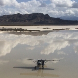
I was out most of the day yesterday flying from Durango to Gateway for b'fast, then a wide perimeter around te Canyonlands area, checking out/landing various strips.
From Gateway,, flying down the Dolores River, to the Colorado, then up the Green, and over to Hidden Splendor. Down to Dirty Devil, Cal Black, and back to DRO.
So my spot was on tracking all the time, and I got about 5 locations, out of about 9 hrs. out. I fly with the Spot on my glare shield, next to my compass, thinking that gave it the best exposure to the sky.
Is anyone getting similar results, and found a better/more reliable location/way to do this?
Thanks Gary
?'s for pilots using spot around south central Utah
Sun Jan 18, 2009 8:24 am
?'s for pilots using spot around south central Utah
Last edited by shortfielder on Sun Jan 18, 2009 9:50 am, edited 2 times in total.
- shortfielder offline
- Posts: 2350
- Joined: Sun Mar 05, 2006 7:14 pm
- Location: Durango, Colorado
- FindMeSpot URL: http://share.findmespot.com/shared/face ... D263l9HKFb
If you want to go up, pull back on the controls. If you want to go down, pull back farther.
My SPOT page
My SPOT page
Sun Jan 18, 2009 8:54 am
Re: ?'s for pilots using spot & flying around south cent
[quote="shortfielder"]I was out most of the day yesterday flying from Durango to Gateway for b'fast, then a wide perimeter around te Canyonlands area, checking out/landing various strips.
From Gateway,, flying down the Dolores River, to the Colorado, then up the Green, and over to Hidden Splendor. Down to Dirty Devil, Cal Black, and back to DRO.
So my spot was on tracking all the time, and I got about 5 locations, out of about 9 hrs. out. I fly with the Spot on my glare shield, next to my compass, thinking that gave it the best exposure to the sky.
Is anyone getting similar results, and found a better/more reliable location/way to do this?
Thanks Gary[/quote
I'm flying with my SPOT velcroed to the glareshield and it seems to work reasonably well . I've got the tracking feature that seems to work about
80-90 % of the time . Still trying to figure out to link it here on BCP.org
Noticed in your pictures your airplane looks like a early Cessna 180 -before
1964 (no third window) but cowl shot looks more like later 180 or possibly
185. Possibly 182 cowl modified > exhaust exit on left hand side I'd say
1956 (in 57 they went to R/H side )182 with 185 cowl ??? It also looks like a STOL kit possably Sportsman . Inquiring minds want to know ??
- 182 STOL driver offline
- Posts: 1529
- Joined: Tue Apr 22, 2008 8:27 pm
Sun Jan 18, 2009 8:57 am


Sun Jan 18, 2009 9:19 am
58S
I tried flying with my spot off to one side, and flying E-W and W-E, it only seemed to work in one direction. That is why I put it in the middle. Apparently it is very sensitive to what part of the sky it is exposed to.
Might have to put a skylight in? Naaaaa
I still wish there was a better plan for satellite phones. Don't mind so much buying the phone, sure would be nice, just don't like getting sucked into the plan($$$$) for as much as I plan to use it. I'd be happy to $5/min. when want to use it, just don't like the monthly fee.
Bill
It is a '56 model, stock cowl. I do have the Sportsman/micro vg's. Pponk eng w/2 blade 88" McC. 8.50's main, AkBush tailwheel.
Gary
- shortfielder offline
- Posts: 2350
- Joined: Sun Mar 05, 2006 7:14 pm
- Location: Durango, Colorado
- FindMeSpot URL: http://share.findmespot.com/shared/face ... D263l9HKFb
If you want to go up, pull back on the controls. If you want to go down, pull back farther.
My SPOT page
My SPOT page
Sun Jan 18, 2009 12:42 pm
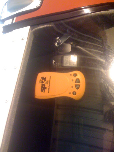
I'm based about 40 SE of Gateway, so not really a true UT guy, but here is what has helped me. The sat is in the southern portion of the sky so try to keep high wings from blocking that. Also the ant is made so that you lay the unit flat with the spot logo facing up. This seems strange with the belt clip orientation but it has helped my success quite a bit. 2 cents worth.
- Meat Servo offline
- Posts: 170
- Joined: Thu Oct 23, 2008 7:27 am
- Location: A mountain valley
Sun Jan 18, 2009 3:58 pm
More than 90% of my tracking messages get through when flying in Southern UT or anywhere else in the lower 48.
I keep my SPOT on a little non slip bean bag holder as far forward as it will fit on the glare shield. By putting it forward as little as possible of the airplane roof will block its view of the satellites. The non slip bean bag keeps the SPOT from sliding around.
The SPOT antenna is located under the SPOT logo on the device and needs to be pointed towards the sky. If it is upside down (logo facing the ground) you will not get nearly as many successful transmissions. Even having the SPOT horizontal will eliminate about half of the available satellites.
The image below shows a sample snap shot of the location of the SPOT satellites and their coverage area. Southern Utah is being covered by 4 satellites in this image. It looks like all of the lower 48 states have 2-4 satellites in view. Northern Alaska only has one. The satellite covering Northern Alaska is down south by the Aleutian Islands and so a view of the southern sky would be required. In Utah there is a satellite with in view in every direction so at this particular time a SPOT beacon pointed in any direction should successfully transmit to a satellite.

The satellites are always moving and the image above is just an example of where they were at one point in time. The above image might make you think that SPOT should work in the middle of the Pacific Ocean which it does not (see the coverage map below). To successfully pass a signal the satellite has to be able to see your beacon and one of the SPOT ground stations at the same time. SPOT does not work in the middle of the ocean or in southern Africa because there are no ground stations there. I'll try to get a map of the ground station locations but do not have one available at the moment.

I'd be glad to try to answer any other SPOT questions you may have. As always, BCP members get a 10% discount on SPOTs and everything else at Prepared Pilot by using the coupon code "BCP"
I keep my SPOT on a little non slip bean bag holder as far forward as it will fit on the glare shield. By putting it forward as little as possible of the airplane roof will block its view of the satellites. The non slip bean bag keeps the SPOT from sliding around.
The SPOT antenna is located under the SPOT logo on the device and needs to be pointed towards the sky. If it is upside down (logo facing the ground) you will not get nearly as many successful transmissions. Even having the SPOT horizontal will eliminate about half of the available satellites.
The image below shows a sample snap shot of the location of the SPOT satellites and their coverage area. Southern Utah is being covered by 4 satellites in this image. It looks like all of the lower 48 states have 2-4 satellites in view. Northern Alaska only has one. The satellite covering Northern Alaska is down south by the Aleutian Islands and so a view of the southern sky would be required. In Utah there is a satellite with in view in every direction so at this particular time a SPOT beacon pointed in any direction should successfully transmit to a satellite.
The satellites are always moving and the image above is just an example of where they were at one point in time. The above image might make you think that SPOT should work in the middle of the Pacific Ocean which it does not (see the coverage map below). To successfully pass a signal the satellite has to be able to see your beacon and one of the SPOT ground stations at the same time. SPOT does not work in the middle of the ocean or in southern Africa because there are no ground stations there. I'll try to get a map of the ground station locations but do not have one available at the moment.
I'd be glad to try to answer any other SPOT questions you may have. As always, BCP members get a 10% discount on SPOTs and everything else at Prepared Pilot by using the coupon code "BCP"
- Prepared Pilot offline
- Posts: 93
- Joined: Sun Apr 09, 2006 10:13 am
- Location: Utah
Sun Jan 18, 2009 5:10 pm
I put mine on its back, as far forward and as near the center as possable of the glare shield, with nothing under it, and the top pointed forward.
I had 5 messages on the map. I had 20 messages in my folder. All from 10:45AM TO 5.30PM. So it sent a lot of messages, but only 5 made it to the map. I thought that they all would have been on the map.
An only 1 OK out of 4 made the map. 2 made my cell phone and computer.
I had 5 messages on the map. I had 20 messages in my folder. All from 10:45AM TO 5.30PM. So it sent a lot of messages, but only 5 made it to the map. I thought that they all would have been on the map.
An only 1 OK out of 4 made the map. 2 made my cell phone and computer.
- shortfielder offline
- Posts: 2350
- Joined: Sun Mar 05, 2006 7:14 pm
- Location: Durango, Colorado
- FindMeSpot URL: http://share.findmespot.com/shared/face ... D263l9HKFb
If you want to go up, pull back on the controls. If you want to go down, pull back farther.
My SPOT page
My SPOT page
Sun Jan 18, 2009 5:42 pm
Yup, I'll second that. That would be a great idea. Hope they are watching. Probably have to be FAA approved. That would muddy the waters.
- shortfielder offline
- Posts: 2350
- Joined: Sun Mar 05, 2006 7:14 pm
- Location: Durango, Colorado
- FindMeSpot URL: http://share.findmespot.com/shared/face ... D263l9HKFb
If you want to go up, pull back on the controls. If you want to go down, pull back farther.
My SPOT page
My SPOT page
Sun Jan 18, 2009 6:46 pm
shortfielder wrote:I put mine on its back, as far forward and as near the center as possable of the glare shield, with nothing under it, and the top pointed forward.
I had 5 messages on the map. I had 20 messages in my folder. All from 10:45AM TO 5.30PM. So it sent a lot of messages, but only 5 made it to the map. I thought that they all would have been on the map.
An only 1 OK out of 4 made the map. 2 made my cell phone and computer.
It sure sounds like you are doing it exactly right. I would have expected a much higher percentage of the messages to get through to the satellites. It sounds like there is a second issue too. Do I understand correctly that when you log onto your SPOT account you see 20 messages listed but only 5 of them show up on your SPOT share page? I think I have your phone number. I'll try to call you to make sure I understand the problem and I'll call SPOT in the morning to try to get the issue fixed.
- Prepared Pilot offline
- Posts: 93
- Joined: Sun Apr 09, 2006 10:13 am
- Location: Utah
Sun Jan 18, 2009 6:50 pm
- shortfielder offline
- Posts: 2350
- Joined: Sun Mar 05, 2006 7:14 pm
- Location: Durango, Colorado
- FindMeSpot URL: http://share.findmespot.com/shared/face ... D263l9HKFb
If you want to go up, pull back on the controls. If you want to go down, pull back farther.
My SPOT page
My SPOT page
Sun Jan 18, 2009 7:08 pm
- OregonMaule offline

- Posts: 6977
- Joined: Fri Sep 01, 2006 9:44 pm
- Location: Orygun
My SPOT page
"They who can give up essential liberty to obtain a little temporary safety, deserve neither liberty nor safety". Ben Franklin
http://en.wikiquote.org/wiki/Benjamin_Franklin
"They who can give up essential liberty to obtain a little temporary safety, deserve neither liberty nor safety". Ben Franklin
http://en.wikiquote.org/wiki/Benjamin_Franklin
Sun Jan 18, 2009 7:47 pm
Hey Rob
I can't tell from the picture where that is, ut thanks
But for anyone else following this thread. The other Rob(prepared Pilot) just called me. We had a 10-15 conversation about this. He doesn 't know me other than I have bought some stuff from him, and spoken on the phone a couple times with him.
He is very concerned, very helpful, and very easy to talk with. This is the kind of person I like to deal with. Most people, if you have a problem, you own it, it is your problem. So, just so ya know, in my opinion, if you buy something from Rob, you are buying it from someone who knows the products that he is selling, and cares that you are satisfied with it after you get.
Gary
- shortfielder offline
- Posts: 2350
- Joined: Sun Mar 05, 2006 7:14 pm
- Location: Durango, Colorado
- FindMeSpot URL: http://share.findmespot.com/shared/face ... D263l9HKFb
If you want to go up, pull back on the controls. If you want to go down, pull back farther.
My SPOT page
My SPOT page
Mon Jan 19, 2009 5:31 am
not Utah , BUT
the things must work,,,Saturday I got called out for a SAR with exact lat&Lon for a snowmobiler...got cancelled as I was about to launch...they called in a helo because of exact know location....changed from SAR to rescue....saved many hours of misery for the victim.....bypassed the search part....that sold me....non of the ad hype/promises of a new product did..actions speak louder than words...they are not just a fad toy..this was in SW Montana
the things must work,,,Saturday I got called out for a SAR with exact lat&Lon for a snowmobiler...got cancelled as I was about to launch...they called in a helo because of exact know location....changed from SAR to rescue....saved many hours of misery for the victim.....bypassed the search part....that sold me....non of the ad hype/promises of a new product did..actions speak louder than words...they are not just a fad toy..this was in SW Montana
Bill White
N2485Q
Twin Bridges, MT
N2485Q
Twin Bridges, MT
Mon Jan 19, 2009 6:05 am
Hi Bill
I'm not saying it doesn't work. But I am concerned with reliability,and/or how to make it work better. As I mentioned, I spoke at length with Rob last night. There does seem to be some quirks here, so we are working on that part.
There also can be some pilot error here. I will be working on that too. I will be going out and checking my tecnique. There are some functions that seem a little vague to me, and questionable as to how to verify. The manual could tell a little more detail.
I like the unit. I just want to make sure it is doing what it is supposed to, and that I know how to make it do what I want.
Gary
- shortfielder offline
- Posts: 2350
- Joined: Sun Mar 05, 2006 7:14 pm
- Location: Durango, Colorado
- FindMeSpot URL: http://share.findmespot.com/shared/face ... D263l9HKFb
If you want to go up, pull back on the controls. If you want to go down, pull back farther.
My SPOT page
My SPOT page
Mon Jan 19, 2009 7:03 am
Gary,
I wasn't taking issue..I concur with you...if our lives depend on them ...and the system works...seems they would figure out how to deal with the reception problem. I just heard the snowmobiler is dead...I'll find out how the SPOT was triggered and by whom...my biggest concern is can the system handle what may become an overload....same issues with PLBs..if every hiker, boater, pilot, snowmobiler, ATVer, etc has one, the system may end up overwhelmed....think about 911 abuse......
.remember the old days when you could buy a n auxillary cell phone antenna that just stuck on a window,,,no wires...that [/i]alledgedly increased the range? HMMMMM $$$$$$$$$
Bill White
N2485Q
Twin Bridges, MT
N2485Q
Twin Bridges, MT
Mon Jan 19, 2009 7:50 am
Bill
Yes, I think the remote antenna would be a GREAT dea. I know they are trying to make improvements. And that Rob will be talking with them soon. I'm sure he will make them aware of the idea of a remote antenna, although I would think others probably have also made them aware.
Have a good day Gary
Yes, I think the remote antenna would be a GREAT dea. I know they are trying to make improvements. And that Rob will be talking with them soon. I'm sure he will make them aware of the idea of a remote antenna, although I would think others probably have also made them aware.
Have a good day Gary
- shortfielder offline
- Posts: 2350
- Joined: Sun Mar 05, 2006 7:14 pm
- Location: Durango, Colorado
- FindMeSpot URL: http://share.findmespot.com/shared/face ... D263l9HKFb
If you want to go up, pull back on the controls. If you want to go down, pull back farther.
My SPOT page
My SPOT page
Mon Jan 19, 2009 9:11 am
Been using mine in a C-180 I tried it clipped up on the Rosens like somebody recommended it keeps shutting off the tracking mode. Tried it up on the dash as far forward as I can get it logo up It keeps shutting off of the tracking mode again no matter which direction I'm going. Defective?
- Glidergeek offline

- Posts: 1937
- Joined: Sat Sep 06, 2008 8:02 pm
- Location: Hesperia
- Aircraft: 1968 P206C
DG 400
Mon Jan 19, 2009 10:17 am
Glidergeek wrote:Been using mine in a C-180 I tried it clipped up on the Rosens like somebody recommended it keeps shutting off the tracking mode. Tried it up on the dash as far forward as I can get it logo up It keeps shutting off of the tracking mode again no matter which direction I'm going. Defective?
If it is actually entering tracking mode and then shutting off on its own it is defective. If this is happening it is the first time I have heard of such a problem. A more likely problem is that it is not entering the tracking mode to begin with. Since sending an OK message and entering track mode use the same button people sometimes send an OK message when they intended to enter track mode. According to the instruction manual to send an OK message you momentarily press the OK button and to enter track mode you hold the OK button down for 5 seconds. Unfortunately many people, myself included, are not very good judges of time. If I have some one with a stop watch time me as I slowly count off seconds I usually say 5 seconds are up after only 4.5 seconds. That is not good enough for the SPOT to enter track mode it needs the full 5 seconds. If I don't hold the button down quite long enough it sends an OK message instead of entering track mode. One way to make sure you have held the button down long enough for the SPOT to enter track mode is to hold the OK button down until the LED next to the button starts blinking. Try it. Instead of trying to judge 5 seconds just hold the OK button down until it starts blinking and I bet your problem will go away. If not, please give me a call.
Rob
801-455-5271
- Prepared Pilot offline
- Posts: 93
- Joined: Sun Apr 09, 2006 10:13 am
- Location: Utah
Mon Jan 19, 2009 12:18 pm
Gary, hi. Rob at prepared Pilot is where I bought my PLB. You are correct, Rob is a class act.
When I moved my SPOT to the top of the wind screen my track hits the sat about 98% of the time. Before it was more like 85%. Same with my wx worx antenna and my gps for my tablet.
I made a bracket that clamps up top to hold all 3.
I'll bet you do the same and your problems will go away.
Rob
When I moved my SPOT to the top of the wind screen my track hits the sat about 98% of the time. Before it was more like 85%. Same with my wx worx antenna and my gps for my tablet.
I made a bracket that clamps up top to hold all 3.
I'll bet you do the same and your problems will go away.
Rob
- OregonMaule offline
- Posts: 6977
- Joined: Fri Sep 01, 2006 9:44 pm
- Location: Orygun
My SPOT page
"They who can give up essential liberty to obtain a little temporary safety, deserve neither liberty nor safety". Ben Franklin
http://en.wikiquote.org/wiki/Benjamin_Franklin
"They who can give up essential liberty to obtain a little temporary safety, deserve neither liberty nor safety". Ben Franklin
http://en.wikiquote.org/wiki/Benjamin_Franklin
DISPLAY OPTIONS
Who is online
Users browsing this forum: No registered users and 2 guests
Latest Features
-
Live to Tell
A Minnesota pilot is surprised to learn that the sudden asymmetric drag of an out-of-rig ski can…Read More -
Creators
Working in some of the Yukon's most beautiful and remote environments, photographer Simon Blakesley captures aircraft in…Read More -
Aircraft Ownership and Maintenance
Upgrading to big tires can make a huge difference in backcountry performance, but with those gains come…Read More -
Tales from Yesteryear
In this tale from bush flying yesteryear, Don Cogger signs up to help Atlee Dodge Jr recovery…Read More


Latest Knowledge Base
-
Destinations
A regional guide with ideas for winter camping destinations in California, Nevada, New Mexico, and Arizona.Read More -
Aircraft
Finding an affordable aircraft that can handle the backcountry for $80K or less? A challenge for sure, but with the…Read More -
Aircraft
01.29.2018 - Zane - Updated tire diameter graphic to add 8.50x10 Guide to tires for use in the backcountry and off-airport landing…Read More -
Pilots
12.22.2013 - Initial article format Operating aircraft on skis and negotiating a snow-covered landscape is an entirely unique skillset and environment.…Read More


