Given recent seemingly consistent, erratic (high) wind conditions in the desert SW, a planned 5+ day trip with multiple friends turned into a quick, one plane, two day trip to various backcountry strips. Some of you might have seen this trip report posted in a few groups on Facebook; For those not on FB, here’s a short write up with numerous pictures.
Goal was to fly over multiple uncharged strips and at least take pictures to assess possible future landing opportunities. A number of strips appeared unusable, even by aircraft with 31” or 35” Bushwheels. I also wanted to test my recently upgraded Insta360 camera.
Camping was GREAT!
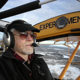
Side note re cameras: I increasingly like to use just one camera. Too much time/hassle and distractions during flight to manage multiple cameras. That being said, there is a super nice multi-camera set up here (https://flightflix.net/rock-steady-camera-system-2/). With one 360°, I can view any angle I chose to see either the scenery, or perhaps to study what my flaps/slats/tailwheel/… is doing—which would require multiple cameras otherwise. Hence, I recently upgraded to the Insta360 One X2 (https://www.insta360.com/product/insta360-onex2/).
I took a number of 360ۣ° videos. For those perhaps not familiar with this video format, once you start the video, you can move your mouse or finger on a trackpad, or you can rotate your phone/tablet to see different perspectives. Links to videos below. Here is one video taking off from Brown's Rim to give you an idea:
Winds were generally light the first day. Perhaps 10 mph headwinds 1,500’ AGL and light at the surface.
If perhaps you’re not familiar with the region, during the 1950’s and 60’s there was a “gold rush” on Vanadium, Radium and of course Uranium. The U.S. government guaranteed a fixed price for uranium. Most of the strips now in Western Colorado and many locales in Utah were put in to supply nearby uranium exploration or mining. You can’t imagine the number of abandoned roads seemingly in the middle of nowhere! Some strips, aka the uber too popular Mineral Canyon, survive in great condition; Most haven’t seen traffic of any sort in decades.
For instance, here’s a view of Spring Creek strip, Colorado: Appears unusable. 38.39016°N/108.69389°W

We wanted to see the "Confluence"...where the Green & Colorado Rivers meet. Here's a picture:

We earlier flew over Rockland, Utah. Google it. Interesting to see some "homes" carved right into the rocks:

Photo of Brown's Rim below

Onward to Fry Canyon. Fry Canyon is known for the ancestral puebloan ruins visible after a short hike. FYI, the strip had recently been "graded" and was in abysmal condition. Fine for maybe 10" or larger tires, but not in the good conditions others reported in the past.


In late afternoon, we departed to check out Lake Powell. This picture of the boat ramp at Hite gives you some perspective on how crazy low the water is...

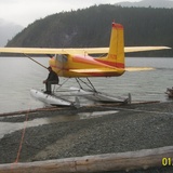
From there we flew to Simplot (also known as "Funky" after a pilot's name) for camping (picture at the top).
Video landing at Simplot:
About 2 am the winds went from relatively calm to 20 gust maybe 30+ I was up the rest of the night tending the plane and thinking of the "fun" takeoff.
Here's a picture at dawn:

We had plenty of fuel. The takeoff was a full-on rodeo. Full control deflections with swirling winds over the canyons and mesa's. After we got to altitude all was smooth (surprisingly enough).
Saw the 2nd highest tailwind & groundspeed ever in my Super Cub on the way home:

Yikes! Good, albeit short, trip. Thank you all for viewing. I'm very blessed to be able to visit these places and to share them with you!