For my next helicopter winter bush flying story I will take a look at what working for the Polar Continental Shelf Project or PCSP is like. You can read about them here: https://www.nrcan.gc.ca/science-and-dat ... gram/10003 The quick version of what PCSP is, is that they help coordinate science projects across the arctic and as part of that provide aircraft, both fixed wing and rotor, for the purpose of getting into the field. This allows for better use of resources and in the past when I’ve worked contracts for them I’ve had two different science teams working together on related projects and sharing my helicopter for cost savings.
These jobs tend to be some of the more interesting that you get up north since every project is different. Some involve tree sampling where you go to the edge of the treeline, that is the area just before tundra starts and trees can’t grow anymore. Other times I’ve taken a crew with a drone to survey grass heights which track goose feeding patterns. Animal capture and tagging is another job or taking geology teams out to sample erosion slumps.
For this contract there is a single project. We will be heading out into the Mackenzie Mountains to the south and west of Norman Wells NWT. Once there we will be looking for caribou herds and well, we will be collecting samples of their poop… This will be analyzed in a lab to determine things like overall herd health as well as numbers. The goal will be to fill around 200 to 300 sample bags with their droppings from as many different locations as possible along their migration and home routes.
Ahead of the start day I get some emails with maps of the routes they want to check out and where our fuel cache is going to be set up. In this case they have purchased 7 drums of fuel that are being flown out to a snow covered landing strip at a cabin site. A twin otter on skis will drop them off a day or two before we start and will pick up the empties some time after the job is done. With the route way points programmed and the fuel delivery confirmed we are good to go!
As is typical in the north, sometimes things don’t go exactly according to plan. This part is rather silly because of all things I ended up locked out of our crew house. You see with a few days of no flying I had stopped taking my helmet/flight bag to the hangar and instead was bringing my laptop bag. I had put my glasses case in that bag as I needed them to drive to the hangar in the morning dark as well as for flying. Of course that was the one item I forgot to transfer over and when I was getting the helicopter ready I noticed I was missing them. I let the engineer know and then drove back to the crew house which is only a few minutes away.
Once I get there I run into a problem. The lock won’t open! I struggle for a bit but then give up. It’s about -28C out right now and I figure the lock has frozen. Not the first time this has happened so I zip back to the hangar. There I picked up one of the buddy heaters and a cloth to make a makeshift heating blanket for the doorknob since we don’t have lock deicer handy. Using the truck block heater cord for power, I heat up the doorknob until it’s hot to the touch and water is visible dripping down the door. Excited that my plan worked I put in the key and, what the heck…it still doesn’t open!
Now thoroughly annoyed I drive back yet again to grab the spare keys that I should have brought the first time. In all my mucking about I noticed that I bent the first key slightly and it was no longer fitting well. Luckily the spare key worked just fine and I grabbed my glasses and head back yet again to the hangar to get ready.
At this point I’m running 30 minutes behind schedule but at least the customer hasn’t shown up yet. We have two crew here and are picking up two more in nearby Tulita before heading to the work site. The engineer and I managed to get the helicopter outside and the blades unfolded when the first customer arrived. I greet them while the engineer puts on a full load of fuel for me. The crew member is a local from the town and was a pleasure to chat with while we waited for the second member to arrive. Turns out I wasn’t that late after all as by now we are 20 minutes past the original meeting time.
They finally show up and the first thing the engineer notices before I do is that he isn’t wearing proper clothing. His jacket looks a little light but it is supposed to warm up to -14C this afternoon. What is more concerning is his boots, or rather lack thereof. Running shoes are not an appropriate set of footwear for walking around in the snow in -28C to -14C let alone if anything happens that strands us in the field overnight. Luckily we have a set of NEOS overshoes that mean in the worst case they can slip those on and be warm. Otherwise they would have been left behind as we are responsible for our passengers well being and that included the possibility of being stranded overnight with whatever gear they brought with them.
With that all taken care of and safety briefing complete (including remembering to dress properly tomorrow) we are ready to go to Tulita and pick up the rest of our crew and the sample gear. It’s a quick 25 minute hop over there and then we end up waiting around again. This half of the crew was also not ready for the meeting time and it’s another 45 minutes before we are ready to go. That too is just part of helicopter life. Sometimes we have mechanical issues with the aircraft or the weather is too bad, other times delays are just because things are harder and slower to do when it’s cold and snowy out.


Tulita airport, both when I landed at the main parking spot and photo of the terminal I took off Wikipedia since I forgot to take one when I was there!
The crew leader and I go over the plan once more and we are also joined by an elder from Tulita. A cool part of the job in these remote locations is that often they involve the local band members, in this case the Sahtu, as hired help, guides or just have members of the community ride along if we have the space. This helps keep the community involved in the projects happening around their land and builds good relationships between them and the various agencies and companies that work up here. We also get a neat side project from the elders of Tulita. It turns out our flight path will be very close to a source of mineral salt they use for medicinal purposes. The elder joining us today will be our guide to that spot so we can pick some salt up for them as well as being a helper for the caribou sampling. With plans set and a rough coordinate for the salt added to the GPS we were finally ready to start the day's work!

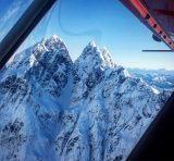
The flight out to the first stop at the mineral salt was gorgeous. With a clear blue sky, almost no wind and a rapidly rising temperature from the previous -36C up to our high of -14C it was turning into a beautiful day. We soon approach the area where the elder expects us to find the salt. After a low pass around the area he thought it was, we see nothing resembling the tendrils of salt rock he described. He thinks maybe there is too much snow so we continue on our way. A couple miles later a previously programmed way point on the GPS pops up that catches my attention. It’s named salt and since it’s within 5 miles of where we currently were I figure it’s a good chance this will be the place.
Sure enough we turn the next bend on the river and see topography very similar to what the elder pointed out the first time. He was right, it’s just around a bend in the river with some cliffs but it had been over a couple decades since he was last there so he mixed the two bends together. Knowing we were for sure in the right place I again slowed down and started crawling along the river to find the salt tendrils. Sometimes us helicopter pilots like to do things like low level river runs to have a bit of fun. Times like this it’s actually part of the job!
Video of the search for salt: https://youtu.be/LUxMyAlAVmU
The elder spotted the location shortly after that video ended and from there it was a matter of landing as close to it as possible. It was up one of the hillsides a little ways which meant a short climb up to it. With an elder and another almost there it was up to the two younger members of the crew to go up and fetch some. I can’t risk twisting my ankle so like normal I’m stuck at the machine while they got their snowshoes on and ready to go. The PCSP team lead in the field is a university student for biology out of Ottawa and Environment Canada employee, he is also the fittest of the group and on point for the climb.


After about a 15 minute wait we see the two of them climbing back down with the spoils. Without the elder up top to show them exactly what they were after it took a bit for them to identify the salt. It looks just like most of the ice that was around but eventually they did spot a sort of cave where it was. A quick taste test to confirm it was salt and then a few axe chops and they had what they were after. Several big chunks each put into a plastic bag were collected and brought down to the elders' delight!

They had 4 bags like this, really does look like ice until you touch or taste it.
Mineral salt in hand we now get to head deeper into the mountains and begin the hunt for caribou tracks. We aren’t just looking for trails but rather spots where they stopped as a group to feed on lichen by “cratering”. They dig holes or craters with their hooves to find the lichen that is their winter diet. That is useful for us since the survey is based around collecting the poop from many animals and when they crater you know there will be a large selection of samples in a relatively small area.


After enjoying the wonderful views we finally spotted our first cratering site. The first thing to be done after landing is a quick prayer and tobacco ceremony led by one of the Sahtu. Thanks are given to the caribou for their sacrifice to feed the people and wishes of good health for the herds are spoken. Then the tobacco leaves are spread by our PCSP lead who was honoured to take part. This is another nice aspect of the PCSP contracts and working with the locals in general. You get to meet them first hand, speak with them and in cases like this even participate in their culture. The elders especially love to talk about the land and how things were and how they have changed.

Now we get into the task at hand. Sampling is done with wooden popsicle sticks and plastic bags. Just scoop the poop in and put the bags into a cooler for transport after they are labelled.

We repeat the same all day long. Follow the route, find a crater site then do a typical snow landing to collect the samples. Some spots had more loose snow than others so each time I had to assume the worst and plan for a white out landing every time. Unlike in Fort Good Hope this time I have 4 passengers on board, a large fuel load and some more gear. This brings even the Astar B2 up to its max gross weight leaving the airport. We started at around 200’ above sea level in that cold -28C. By the time we got into the mountains the altitude was ranging from 1000’ to 4000’ above sea level and the temperatures were rising to a balmy -10C.
The B2 is still a very capable machine and it was still pretty cold overall so performance wasn’t near any limits but it does mean more care had to be taken when landing or departing. Nice gentle approaches are needed to ensure a loaded rotor disk before committing to a landing. If you hot dog it and come in too fast you might find yourself unable to slow the helicopter down in time and end up in a “settling with power” situation. In helicopter terms Settling with Power (aka power required exceeds power available) is kind of like driving too fast and trying to slam on the brakes at the last second. The brakes are working just fine but you didn’t leave enough stopping distance and end up rear ending the car in front of you. In this case it would be instead of a lack of just braking distance it’s also lack of power to stop the helicopter before hitting the ground and a heavy helicopter needs more power and distance to stop moving. Again this isn’t a big deal if you fly according to conditions but something to keep in mind when going from a lightly loaded machine in the lowlands to a heavily loaded one in the mountains.

https://youtu.be/ZXsY9bBeyj4 - this video from the above picture landing site shows just how nice the area is to work in!
The rest of the first day goes fairly well. We hit several sites and completed two different loops of our plan and burned 2 of 7 drums. This was a great first start and we couldn’t complain about the weather. The forecast for the next two days was also going to be excellent with light winds, clear skies and temperatures nearing -2C! After dropping off all the crew we even leave the helicopter outside overnight. Faster to just toss the main body cover on and plug it in. With no overnight snowfall expected and beautiful conditions we didn’t even bother with the blade covers and for once that didn’t bite us the next day.
Next day was a much smoother start. No issues with crew house doors or pushing helicopters around. Another quick stop in Tulita to pick up the rest of the crew and some new elders to show around and it’s go time again. Back in the mountains we spot a nice looking river with what appears to be a good collection of tracks and possible crater. Elder in back pipes up on short final to the spot that those look like moose. This close to landing team lead decides that we might as well confirm it. I land on my target bush in the snowball and we all stay put inside while the leader hops out to confirm. Sure enough a few seconds later he hops back in and goes “Yep, that’s moose”. Pretty valley at least!

Moving on we start getting a little deeper into the mountains and every turn seems to bring a fresh new amazing view. This quick video gives good example: https://youtu.be/igreDQlUwDY
Now with new knowledge of what the difference between moose and caribou tracks look like from the air we spot some more caribou trails and nice crater sites to check out. I’ve mentioned in the wildfire stories before that flight planning as a helicopter pilot is a very different kind of challenge than the more typical airport to airport airplane flying. I have no set altitude during this search, we simply fly whatever gives about 500’ to 1000’ above the ground which means our altitude on the altimeter set to sea level will be changing all the time as we cross valleys and mountain ranges. I also don’t have a set airspeed as we zoom around at the max 110 knots that I can squeeze out of this Astar (with two cargo cheeks and a full basket we are not the most aerodynamically slick configuration) when crossing mountains or areas with no tracks at all and then slow down to 60 knots and drop lower when we start seeing tracks again. This means my power usage is all over the place and so is my fuel burn.
So how do you calculate fuel burns to figure out how far out you can go? Well that’s down to educated guessing. We use an average of 180l/hr (48gal) or 33%/hr as the gauge is based on percent of fuel for the Astar. It holds pretty true at max cruising power. Because I’m using less power for a large amount of the survey I can end up stretching that number quite far. With a full fuel tank in theory 180/hr means 3 hours of flying time till the tank is completely empty. Company and Transport Canada require I have 15% fuel left or a bit more than 20 minutes. However with my low power survey flying I can stretch that to landing with 20% fuel after over 3 hours of flying. So that still brings up the question of how do I know how far I can go? I can’t guarantee what we will see after the next turn so I have no idea if I’m going full max continuous power to the next good site or will be cruising at low power and landing often.
The answer is in how I plan the route. We have the plan in the morning of where we want to go and I will either plug in some GPS spots along that route or just use existing ones that are close enough. Once I visualize the area we will be searching and have the route planned I will then set the GPS route to go direct to my fuel cache. That gives me a distance to the cache that updates in real time as well as an ETA based on my current speed and the local winds. From there I can look at what percent of fuel I have left and can decide if it is time to head back or not based on cruising at 110 knots (modified for wind if required). It’s all mental math but nothing too difficult to work out on the fly given I don’t need answers down to the decimal point or anything like that. Aim to land with 20% fuel and that gives some more buffer to land with 15% if the winds change. From there we just go as far along the route as I feel comfortable with the fuel remaining and pick it up from that point after a fuel stop.
We have just started the day however so I still have 50% fuel to play with before we start thinking about the cache just yet. Our next crate site is both very large and like this entire project is turning out to be, very beautiful for a stop as well. Not only do we have a huge group of caribou passing by here by the tracks but the frozen lake it’s next to has just started to have the snow disappear on the surface and reveal cool looking blue ice and water reflecting the sun.
Video here for the panorama: https://youtu.be/wzuIdwgDBPw


You can see the tracks all around the area and the crater where I actually landed so less walking needed for sample collection. With so many samples to collect they will be here awhile. Time for lunch! After walking around taking those pictures it’s time to eat. The crew will use fuel stops to eat their food but I’m going to be busy then and prefer to eat before risking getting Jet A or B on my hands, even if I don’t spill the fuel gloves tend to have some residual inside them. I was smarter today and remembered to put my bag in the cabin so it stays above 0C. Since I have a much more full backseat I’m forced to put my bag under the seat. Since people are coming in and out with snow on their boots and the aircraft heater will melt that into water on our longer jumps between sites I have to protect it. A towel from the crew house wrapped around my bag keeps the water mostly away from it allowing me to have a warm and dry lunch. Little things like this you pick up over the years really do help improve quality of life in the field!
With lunch done as well as the site we continue on with the rest of the day's samples. When not eating or taking pictures I have another activity to keep me busy while the crew works. An ebook is the greatest thing for fighting boredom on long waits which are common no matter what customer I’m flying. With bags as pillows the back seat of an Astar is a pretty comfortable spot to relax with a book and with the ebook I have more novels that I can hope to read in a full month-long tour. Today I can’t complain about the view outside while reading safe from the wind inside.

After hitting a few more sites it’s time to head in for fuel again. You can see in the pictures below the tracks made by the ski equipped Twin Otter that dropped off the fuel for our cache prior to the job start. This highlights one of the reasons I love helicopters over bush planes. They get to fly over the same terrain most of the time but they never get to hang out in it and really explore like we get to. Dropping the drums and heading home is all they got to do while I spent 3 days going up and down each valley and seeing the wildlife and scenery up close. In general bush helicopter flying has a lot more freedom of choice when it comes to how we get the job done. Very rarely is the job a simple A to B flight, we have something we need to do on the ground and it is entirely up to me and the crew to figure out how to accomplish this. We also have options for things like deciding to randomly pick a mountain peak to have lunch (or next to a lake that looks like good fishing) or if we see something neat we can just decide to drop in for a closer look. Even better are the times we finish early and the helicopter is already prepaid for more hours then we used. Customers already paid for it so they turn into tourists and have us take the long way home or again look for cool fishing spots or whatever. Even better are the times we finish early and the helicopter is already prepaid for more hours then we used. Customers already paid for it so they tLife of an Ice Helicopter Pilot Part 4: Polar Polar Continental Shelf Project (Final Ice Story)urn into tourists and have us take the long way home or again look for cool fishing spots or whatever. I had one memorable job where we finished 20 hours early (already prepaid) and so went up and down Bathurst Inlet looking for waterfalls,Kattimannap Qurlua was particularly spectacular, and the rest of the time fishing anywhere that looked nice.
 - Twin Otter Tracks
Another thing about the fuel cache itself that is slightly hard to tell from the pictures is that I actually have to land in a little circle around the drums, moving around each time. Because of space, weight and typically not needing a huge hose, the lines we use are not very long. They won’t reach much more than the 2 drums closest to the fuelling cap just behind the basket. Buried in deep snow like they are there is no way to easily move them around so better to just land next to them each time regardless of where the wind is coming from.