Anyone know anything/have any info on an airstrip in northern Montana called Wurtz (MT17)? I came across it on shortfield.com and it looked like a neat place:
-Sam
[airport]MT17[/airport]
Wurtz?
Sun Nov 23, 2008 2:27 pm
Sun Nov 23, 2008 4:41 pm
Sun Nov 23, 2008 4:42 pm
Go to www.recreationalaviationfoundation.org/raf/about.htm it has a picture and a little information.
- montanamaule offline
- Posts: 10
- Joined: Tue Jun 05, 2007 7:25 pm
- Location: Montana USA
Wed Nov 26, 2008 11:16 am
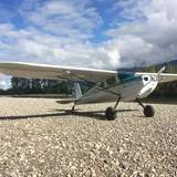
I landed there this summer in my Super Cub and also walked the whole area this month hunting deer. It is rough and narrow and not for most tricycle planes with minimum prop clearance. You need to be able to pick you landing spot and then hit it. With the bigger tires on the Cub it is not near so rough. Here's a picture of the Cub with 8.5's on and with these tires it is rough enough that you notice it.
It is a beautiful area. Both ends of the strip end at the North Fork of the Flathead River. The strip was built on a bow in the river. The other side of the river is Glacier National Park. The strip was originally private and was the bought by the Forest Service. The road leading to the strip is closed during the fall and winter months and the assumption is that the strip is then too although the FS is inconsistent in their treatment of the strip.


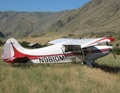
Here's another view from a few years ago, before the fire. You get a better view of the entire strip and the roughness. That is a tricycle gear plane out there in this picture. As I said, you need to be able to hit your spot.
It is a beautiful area. Both ends of the strip end at the North Fork of the Flathead River. The strip was built on a bow in the river. The other side of the river is Glacier National Park. The strip was originally private and was the bought by the Forest Service. The road leading to the strip is closed during the fall and winter months and the assumption is that the strip is then too although the FS is inconsistent in their treatment of the strip.
Here's another view from a few years ago, before the fire. You get a better view of the entire strip and the roughness. That is a tricycle gear plane out there in this picture. As I said, you need to be able to hit your spot.
making 'em spin. . .
Thu Nov 27, 2008 9:54 am
If it is on USFS land it is not private. They just haven't changed the symbol on the chart yet. Ryan Field, a little SE of Wurtz has been donated for public use. The previous owners still live there. In order to land there you need to contact the MPA first, but it's no longer a private field.
- Bonanza Man offline
- Posts: 909
- Joined: Fri Jul 07, 2006 3:42 pm
- Location: Seeley Lake
Thu Nov 27, 2008 6:18 pm
DISPLAY OPTIONS
Who is online
Users browsing this forum: No registered users and 1 guest
Latest Features
-
Live to Tell
A Minnesota pilot is surprised to learn that the sudden asymmetric drag of an out-of-rig ski can…Read More -
Creators
Working in some of the Yukon's most beautiful and remote environments, photographer Simon Blakesley captures aircraft in…Read More -
Aircraft Ownership and Maintenance
Upgrading to big tires can make a huge difference in backcountry performance, but with those gains come…Read More -
Tales from Yesteryear
In this tale from bush flying yesteryear, Don Cogger signs up to help Atlee Dodge Jr recovery…Read More


Latest Knowledge Base
-
Destinations
A regional guide with ideas for winter camping destinations in California, Nevada, New Mexico, and Arizona.Read More -
Aircraft
Finding an affordable aircraft that can handle the backcountry for $80K or less? A challenge for sure, but with the…Read More -
Aircraft
01.29.2018 - Zane - Updated tire diameter graphic to add 8.50x10 Guide to tires for use in the backcountry and off-airport landing…Read More -
Pilots
12.22.2013 - Initial article format Operating aircraft on skis and negotiating a snow-covered landscape is an entirely unique skillset and environment.…Read More


