I've flown quite a few times with a friend who owns a Beach A36, and he bought a Garmin 696 last year and gets the XM Wx subscription with it. I liked having the Nexrad and lightning strike info in the cockpit in near real time, and it helped us pick our way through T-storms a couple of times.
I didn't want to pay the purchase price or subscription fees for the Garmin, however, so I bought an Anywhere Map ATC for less than1/4 the price ($600) of the Garmin. The ATC has an upgrade available for XM Wx at $700, and the monthly subscription fee at $55/month also seemed a bit steep, so I kept putting off the upgrade.
(Anywhere Map has a newer unit out now, called the Quadra, for the same price but it has better capabilities, such as WAAS gps and faster performance)
This year, however, we've had an unusual string of fogged in/clouded up as well as T-stormy days on my usual weekly commute between Albuqerque (KAEG) and Hobbs (KHOB), so I finally broke down a week and a half ago and ordered the WxWorx receiver for my ATC, but it didn't arrive until a couple of days ago while I was in Hobbs.
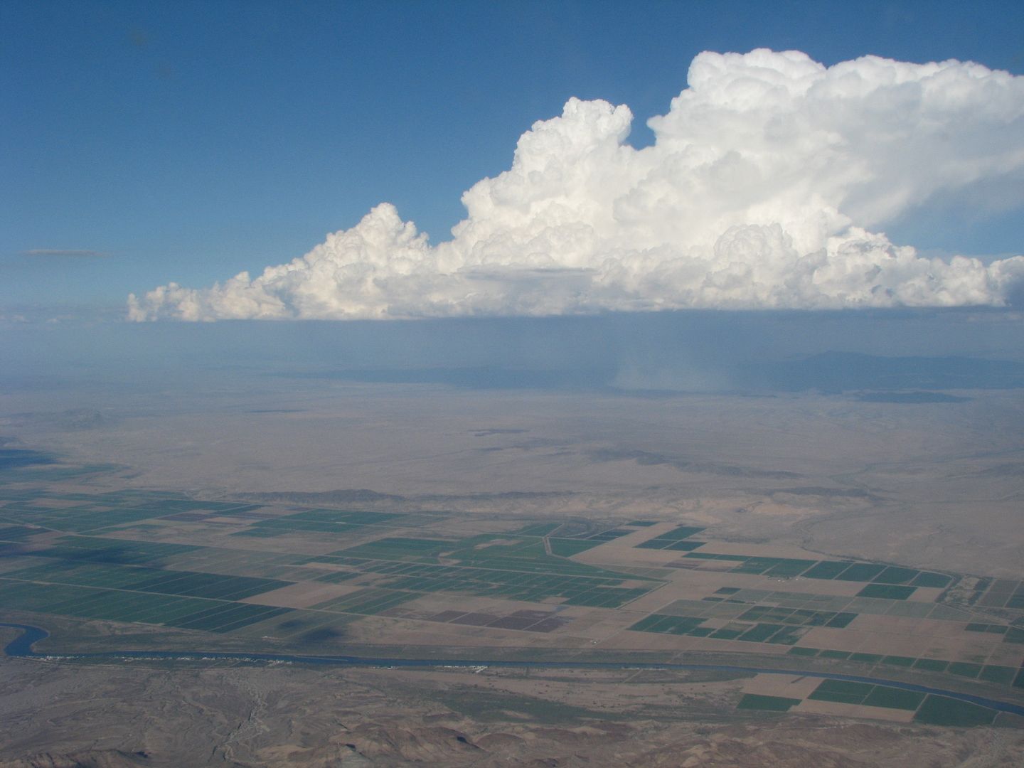
Late yesterday afternoon, while making my way home from Hobbs, and without the XM Wx in the cockpit, I found that I was confronted with a long (hundreds of miles?) line of T-storms, on a north-south axis, standing squarely in my path back home. They were extremely dark and nasty, with lots of lightning strikes. Yet those cells weren't on the NexRad when I checked weather an hour before launch.
I usually do flight following on cross-country flights, and Albuquerque Center began feeding me advisories as I deviated to the north to try and get around the nearly continuous line of storm cells. Finally Albuquerque Center advised me to make a landing at Santa Rosa (KSXU) to wait out the storms, as "there's stuff all around Albuqerque and north to Santa Fe". I elected to take their advice, and flew another 30 some miles northeast to land at KSXU. Once on the ground, I went into the un-staffed airport office, got on the internet and checked out the NexRad radar and saw that the big T-storm cells did in fact surround Albuquerque on three sides (east, south, and west), but the north was mostly clear. I hemmed and hawed around for awhile and after watching several updates of the NexRad, I finally decided to launch again and head to the north to get around one big cell near KSXU, then headed due west and made my approach into the north end of Albuquerque just fine.
Moral of the story? I'f I'd had the Xm Wx with me in the cockpit, I could have easily seen that the Center controllers were being a bit overly cautious in their assessment of the weather (I can see why - I won't criticize them for erring on the side of caution), but based upon my own reading of NexRad, I could have saved myself the detour to Santa Rosa. The money I would have saved on avgas from not making that detour would have paid most of my first month's subscription fee.
Yes, cockpit Wx is not cheap. But I believe the XM Wx has utility that can be measured in dollars and cents, as well as heightened mental relief, not to mention that it could help avoid flying into a really bad scenario, especially when visibility isn't all that good and the T-storm cells are not necessarily evident to the pilot in the cockpit.
Also, having METARs, TAFs, ground winds, and winds aloft in the cockpit can really come in handy when you're searching for an alternate airport. Here in New Mexico, we have places where you can't get ahold of Flight Watch or talk to Center to get that info. Being a regular cross country flyer, diversions for changing weather are an not-uncommon affair for me.
XM Weather - how useful is it?
Fri Jul 16, 2010 11:34 am
XM Weather - how useful is it?
Last edited by nmflyguy on Sat Jul 17, 2010 9:27 am, edited 1 time in total.
"Sometimes the magic works, and sometimes it doesn't"
Chief Dan George, in "Little Big Man"
Chief Dan George, in "Little Big Man"
Fri Jul 16, 2010 2:09 pm
Re: XM Weather - how useful is it?
We just put it in the 182 this spring and the BCP fly-in was the second long XC I've done with that unit. You just can't beat being able to look hundreds of miles down range and see what the current and forecast weather is. Flying from CT to UT a few years ago, as well as up to NW MT two weeks ago, XM weather was invaluable and I love having it on board. With Garmin's new Aera out, you can get the 496 from $1,000 -$1,500, less than $2,500 installed. You can also do the Aviator lite package which is half the cost of full subscription. You loose winds aloft and cloud mosaic, but still have most wx products you'd want to have.
- Grassstrippilot offline


- Posts: 3536
- Joined: Wed May 31, 2006 6:17 am
- Location: Syracuse, UT
- FindMeSpot URL: https://share.garmin.com/WolfAdventures
- Aircraft: Cessna 205
Fri Jul 16, 2010 2:48 pm
Re: XM Weather - how useful is it?
Had XM on my 496 when i was down in the lower 48, wish it covered up here in Alaska. On long cross country flights its hard to beat, especially if you really need to get were your going. I used the avaitor light since it was alittle easier on the pocket book.
Had a simular situation flying up to Kansas from Texas and hit a line of thunderstorms from West Texas all the way to Chicago and was able to pick a spot to miss the worst of it. There is a "delay" time between whats happening and what Nexrad is reporting, but you can extrapolate whats on Nexrad and what your seeing. Had the winds aloft feature for awhile and that was really nice for choosing crusing altitude without having to use the gas to find out if the forcasted winds were accurate or not. hard to justify the cost unless i did alot of cross country flying. Sadly, now that i am actually flying to several villages every week XM dosent reach this far north.
I would aggree with grassstrippilot and just get a 496 now that they are "outdated"
Chris

Fri Jul 16, 2010 2:48 pm
Re: XM Weather - how useful is it?
XM/WX - Don't leave home without it! 
"illegitimati non carborundum est"
Fri Jul 16, 2010 3:29 pm
Re: XM Weather - how useful is it?
It's worth every penny. It's either play with this funny gadget goodie or talk to Flightwatch with questionable reception. Plus, you get the info on the ground, in the backcountry. I recommend it.
- Zzz offline


- Posts: 2854
- Joined: Fri Oct 08, 2004 11:09 pm
- Location: northern
- Aircraft: Swiveling desk chair
Half a century spent proving “it is better to be thought a fool than to open your mouth and remove all doubt.”
Fri Jul 16, 2010 4:03 pm
Re: XM Weather - how useful is it?
slowhawk wrote:I would aggree with grassstrippilot and just get a 496 now that they are "outdated"
Chris
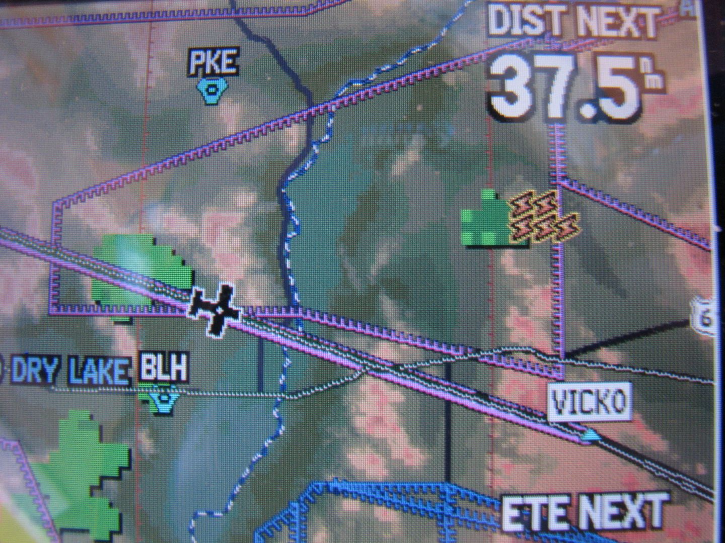
Chris - you might also want to check out the Anywhere Map Quadra at http://www.anywheremap.com. It's quite a bit cheaper to buy and maintain than even the "old" 496s ($600 for the standard Quadra, and $800 for the Quadra Max which has built-in seamless sectional maps), yet has much better capabilities. They have a feature by feature comparison table on the website showing the Quadra vs other products including the Garmins. For instance, the Quadra with XM Wx/WxWorx receiver uses a bluetooth connection vs. wires, and it can be updated without a computer connection using its built-in WiFi. The screen resolution is much better on the Quadra than even the highest-end Aera model, let alone the Garmin 496. I really like the touch screen interface, which Garmin finally adopted with the Aera. The Aera model that is closest to the capabilities of the Quadra, however, costs nearly three times as much, and still doesn't have all the features of the Anywhere Map device.
Not only is the hardware cheaper, but the subscriptIions are dirt cheap for the Quadra's as compared to Garmin. You get all the nav data updates (every 28 days), plus daily TFRs, plus taxi diabrams, plus all the sectional map updates for only $115 a year vs. $495 for Garmin (which doesn't offer the electronic sectionals at all).
As I said in the first post, I bought the ATC unit last year, and it's been working great. I've had a couple of software glitches that the tech support guys fixed for me online, other than that it's been flawless. I'd upgrade to the new Quadra, but I like the ATC so much I'll probably stick with that til it breaks.
Most pilots are most familiar with Garmin, which has dominated the aviation gps market since it began, but there's other products out there that are giving Garmin a run for its money.
Duane
"Sometimes the magic works, and sometimes it doesn't"
Chief Dan George, in "Little Big Man"
Chief Dan George, in "Little Big Man"
Fri Jul 16, 2010 4:27 pm
Re: XM Weather - how useful is it?
Sounds good, the garmin update costs always irritated me cha-ching! But, these days i'm flying all remote, unattended gravel, except for the jonts over to Nome for fuel so the AOPA, taxi diagrams, ect are'nt any help anyway. Since the hills around here don't change, unless we get another BIG earthquake  , doubt i'll be doing any updates for a long while.
Chris
Chris
Fri Jul 16, 2010 5:38 pm
Re: XM Weather - how useful is it?
I use the Aviator Lite package with the XM Weather, and find it invaluable for enroute decision making. Being able to scroll out to find current wx makes it so easy to plan fuel stops or get prepped if I have to file to get in somewhere.
The delay in the NEXRAD is a non-issue at our speeds (slow), and what really has saved my butt a bunch of times now up here in the Wilds of Nevada, is the TFR depictions. Been more than once I've hopped in the airplane to go buzz coyotes, just to have a red ring pop up where I am or where I'm going, showing a military or fire TFR I had no clue about (because I didn't bother calling FSS). It's a real adrenaline jolt to see that, and realize that without the XM I'd a been out there right in the middle just waiting to get a violation.
Of course a guy gets a bit spoiled with XM radio, moving map GPS and all the other cool toys too.
Gump

Fri Jul 16, 2010 7:17 pm
Re: XM Weather - how useful is it?
It's almost a "Don't leave home without it" item.
Pat
Pat
Fri Jul 16, 2010 8:42 pm
Re: XM Weather - how useful is it?
West of the Rockies you sometimes get a chance to calibrate the XM Wx.
Hmmm.... isolated cell, across the Colorado River, about 10 o'clock...
Yup. There he is.
This stuff is nice to know when you are east of the Rockies and these suckers can hide in 3-5 mile haze.
Oh, and ditto what Gump said about TFR's. They can pop up after you depart and you could be descending over the Sierra's through a hornet's nest of firefighting P-3's.
I had a subscription for my "ancient" Garmin 396. Go for the full Monty. I saved several flights based on winds aloft and metar information. It's worth it. You'd spend that much on aviation magazines.
YB
- Yellowbelly offline

- Posts: 355
- Joined: Wed Apr 27, 2005 9:03 pm
- Location: Beautiful southern Utah
Maule M-7-235C
I'm lost
but I'm not afraid
I'm lost
but I'm not afraid
Sat Jul 17, 2010 4:25 am
Re: XM Weather - how useful is it?
I had weather radar service in the 430 for several years and got good use out of it, especially when making the 600 nm trips north in the summer. It was quite helpfull in skirting problem areas and planning the next move. Now that I am in the north country all the time, I have XM weather in the 496 and get good use out of it when out and about in the boonies. One note, to get XM weather in Canada, the subscription fee is a lot higher than the States. I just subscribe in the summer. Steve

Sat Jul 17, 2010 8:51 am
Re: XM Weather - how useful is it?
steve wrote:One note, to get XM weather in Canada, the subscription fee is a lot higher than the States.
Just a rumor mind you, but I heard from friends of mine in Bella Coola BC that they had an associate in the States that let them use his address to register their XM and Dish Network in the US. I'm sure it's illegal.
Gump
Sat Jul 17, 2010 9:09 am
Re: XM Weather - how useful is it?
XM Wx is the cats meow in your plane. I waited 30 yrs to get something like this in the cockpit.
I have had it since the 696 came out, and Garmin pisses me off with what I have to pay, until I need it. I have been able to complete flights by avoiding wx that I could see on the 696. Even though flight watch was pitching "the sky is falling" to everyone on freq.
FW was recommending that we get down and wait out some tstorms. XM Wx not only showed them, it gave the tops, the direction they were moving and the speed they were moving at. A 50 mile detour to the west resulted in a beautiful uneventful conclusion of the trip.
I sometimes get tempted on the Anywhere Map, but I don't want to rely on Microsoft O/S in the cockpit. The Garmin unit is solid and reliable. I have had Garmins since the 196 and NEVER had an issue with a unit. After all, is it my a** and my family in the plane. I just feel the extra $ I'm paying with the Garmin give me peace of mind.
My 2 cents worth on the subject.
- rfinkle offline


- Posts: 334
- Joined: Sat Feb 21, 2009 9:27 pm
- Location: KSZP, KCCR, 18AZ
- FindMeSpot URL: http://share.findmespot.com/shared/face ... gujelTKUbh
You're never too old to learn something stupid.
Sat Jul 17, 2010 9:42 am
Re: XM Weather - how useful is it?
rfinkle wrote:I sometimes get tempted on the Anywhere Map, but I don't want to rely on Microsoft O/S in the cockpit. The Garmin unit is solid and reliable. I have had Garmins since the 196 and NEVER had an issue with a unit. After all, is it my a** and my family in the plane. I just feel the extra $ I'm paying with the Garmin give me peace of mind.
My 2 cents worth on the subject.
I bought my Cherokee 180 fifteen months ago (my first airplane purchase), which has a panel mount Garmin 150XL in it, and I bought the Anywhere Map ATC to mount on the yolk at the same time. The Garmin has quit on me several times in the air since then, and I've had it in the local avionics shop a couple times, and they've not been able to troubleshoot the issue (it periodically resets itself - and following Murphy's Law, it happens only when it's least convenient). On the other hand, the ATC has been 100% reliable, having never let me down in the air in the 250 hours or so I've flown with it so far. The information presentation and the user interface on the ATC is also much more friendly and easy to use, even in turbulence.
The end result is I that rely on the ATC in the cockpit, for myself and my family, and the Garmin is there as a sometimes reliable backup for the ATC, which so far I haven't really needed.
Am I saying that my experience is definitive when it comes to Garmin vs. Anywhere Map? No, of course not. But I also don't believe it's accurate to assume that the Garmin is reliable per se, and that Anywhere Map is suspect per se.
"Sometimes the magic works, and sometimes it doesn't"
Chief Dan George, in "Little Big Man"
Chief Dan George, in "Little Big Man"
Sat Jul 17, 2010 9:54 am
Re: XM Weather - how useful is it?
Not that I'm anti-Garmin either .... I'm not IFR certified yet, but I expect I will go for that rating before too much longer, just because I get skunked by low clouds quite often on my weekly commutes to Hobbs. I'm saving my pennies (a lot of them) to buy a Garmin 430W as prerequisite for the IFR training, because the published WAAS approaches are quickly becoming the norm for most of the rural airports I'm likely to fly to.
However, on the other hand I know that I won't like the Garmin user interface much, including all the darn knobs and buttons on the 430W, which is the same 1990s technology used on my 150XL. One of the reasons I'm reluctant to invest in the G430W now is that Murphy's Law dictates that a month after my purchase, Garmin will announce their new G4XXW gps/nav/com with the touch screen interface that's on the Aera!
However, on the other hand I know that I won't like the Garmin user interface much, including all the darn knobs and buttons on the 430W, which is the same 1990s technology used on my 150XL. One of the reasons I'm reluctant to invest in the G430W now is that Murphy's Law dictates that a month after my purchase, Garmin will announce their new G4XXW gps/nav/com with the touch screen interface that's on the Aera!
"Sometimes the magic works, and sometimes it doesn't"
Chief Dan George, in "Little Big Man"
Chief Dan George, in "Little Big Man"
Sun Jul 18, 2010 5:12 am
Re: XM Weather - how useful is it?
Gump, or anyone else that knows. The story I got, is that the radar will only work in the US, unless an additional fee is paid to have the Canada radar turned on. My subscription, is payed through a US account, with Canada added. I will say that the weather service I used on the 430 ( before XM) did work in Canada. If anyone knows that the radar sites work in Canada's interior and there is no need to pay the extra, please let me know. Thanks. Steve
Sun Jul 18, 2010 6:37 am
Re: XM Weather - how useful is it?
steve wrote:The story I got, is that the radar will only work in the US, unless an additional fee is paid to have the Canada radar turned on.
Here's the pricing/services breakdown:
http://www.xmwxweather.com/aviation/dat ... icing.html
Gump
Sun Jul 18, 2010 10:08 am
Re: XM Weather - how useful is it?
Thanks Gump. That is how I understood it and do have the Aviator for the that price. Was hoping there was a way to slip under the wire, but it doesn't look like it.
We went about an hour north yesterday, to fish in a remote lake where we have a boat cached, on the way back I could see yellow and green splotches on the radar to the west of us, but had no worries knowing what it was and that we would get back ahead of it. Comforting to know what is out there. Steve
We went about an hour north yesterday, to fish in a remote lake where we have a boat cached, on the way back I could see yellow and green splotches on the radar to the west of us, but had no worries knowing what it was and that we would get back ahead of it. Comforting to know what is out there. Steve
Sun Jul 18, 2010 12:00 pm
XM Weather - how useful is it?
I will admit that I don't have the most recent 411, but at one time as recent as last November, if you ordered the Master Mariner package you got everything that is included in the Aviator package (yes even aviation-specific data) plus additional marine stuff (like isobars and offshore forecasts) that are also useful to us, all for five dollars less. I guess it is just one more example how we rich pilots should be expected to pay more 
In this case it is particularly interesting to consider because -guess what- Canada radar is included in the Master Mariner where it isn't in the Aviator.
Now, since my info is dated by seven or so months someone is going to have to go out on a limb and try it to confirm. Don't bother calling and asking XM customer service, they have always been clueless about this nuance and will likely say "huh?" And yes, the info on their site does not list specific aviation data available for the Master Mariner. You'll have to trust my info that it is there. You wouldn't be gambling much since there is no commitment...if I'm wrong you could call up the next day and order an aviation package instead.
From Gump's link go to the marine data pricing page.
- onceAndFutr_alaskaflyer offline
- Posts: 1319
- Joined: Sun Apr 23, 2006 4:23 pm
- Location: Keweenaw Peninsula, Michigan and Carson Valley, Nevada
Sun Jul 18, 2010 2:34 pm
Re: XM Weather - how useful is it?
Hey Richard,
Are you getting XM weather data in Alaska? I lose the signal just west of Ft Nelson and don't see it again until i head back that way.
Your right about the XM service reps, cluless just begins to discribe my dealings with them. They say there is coverage up here, but i have come to the conclusion that it must be much further south. I wish i had XM up here, the very few AWOS stations that are around Norton sound are not terribly reliable.
Chris
DISPLAY OPTIONS
Who is online
Users browsing this forum: No registered users and 0 guests
Latest Features
-
Live to Tell
A Minnesota pilot is surprised to learn that the sudden asymmetric drag of an out-of-rig ski can…Read More -
Creators
Working in some of the Yukon's most beautiful and remote environments, photographer Simon Blakesley captures aircraft in…Read More -
Aircraft Ownership and Maintenance
Upgrading to big tires can make a huge difference in backcountry performance, but with those gains come…Read More -
Tales from Yesteryear
In this tale from bush flying yesteryear, Don Cogger signs up to help Atlee Dodge Jr recovery…Read More


Latest Knowledge Base
-
Destinations
A regional guide with ideas for winter camping destinations in California, Nevada, New Mexico, and Arizona.Read More -
Aircraft
Finding an affordable aircraft that can handle the backcountry for $80K or less? A challenge for sure, but with the…Read More -
Aircraft
01.29.2018 - Zane - Updated tire diameter graphic to add 8.50x10 Guide to tires for use in the backcountry and off-airport landing…Read More -
Pilots
12.22.2013 - Initial article format Operating aircraft on skis and negotiating a snow-covered landscape is an entirely unique skillset and environment.…Read More


