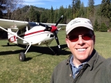
Yesterday I took my ex-chief pilot (he just returned to flying the line in May) and his wife flying in Southern UT. It was a "10" kind of day for flying! We didn't even feel a ripple until about 2:30pm. I picked them up in Heber, UT and from there we headed down to Mineral Canyon. I hadn't been in there for a few years and the strip is in great shape. Hard and quite smooth except for the very last bit of the south end where it is uneven from vehicles being on it. Not a factor though. Thanks to those guys that recently went in and cleared some brush!
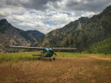
From there, we flew over Canyonlands and the confluence of the Green and Colorado Rivers. We then turned to the northeast to go see Delicate Arch before turning west for the San Rafael Swell and Mexican Mountain. We joined the swell just south of I-70 and flew it up to Mexican Mountain. Mexican Mountain was in great shape and the extension of the runway is noticeable. Great to have. The mud from a few weeks ago has all dried up and is not a factor. There we had a really nice picnic lunch in the shade of the trees which were about halfway changed to Fall colors.
After a nice lunch, we went for a walk to checkout an RV-8 who a few days earlier overran the west end of the runway. Apparently he was advised by the other aircraft he was with that the east end was a little soft and that he might want to land long. Unfortunately, he wasn't able to get it stopped in the distance he left himself. The left wing leading edge was caved in and the left main was ripped off. Fortunately, from what I understand he was ok. From there we walked down to the petroglyphs to check them out.
Needless to say, this pretty much blew my friends minds in a good way. I think that a pretty strong seed of getting their own aircraft was planted. We couldn't have asked for a better day! After a quick fuel stop at Huntington (really nice new facilities they've put in there by the way!) and we were on our way back home.
And now, ANOTHER REASON TO HAVE A SPOT!!!
This day took kind of a strange twist. At 11:45am, Dee got a knock on the door. Standing there was an officer from our local police department. He asked if I lived there and then asked her if I was flying. For a brief moment, Dee thought that she was a widow and it scared her. He told her it was probably nothing but that she might want to call my cell. She told him that she could look at my Spot page and see where I was. She had to explain what a Spot was and then looked up my location, which showed that 1 minute before I was over Canyonlands. The officer didn't have any details to give her as to why he had been dispatched to do a wellness check, which I don't think was very cool. If it wasn't for her being able to check my Spot and see where I was and that I was ok, I can't imagine the worry and concern she would have had for several hours. That right there makes any cost for the Spot worthwhile!
So when I got home and heard about this, I talked to a police officer friend of mine (ccstricker) that gave me the number for the county dispatch. I called them and this is what I learned. Around the time I went through Weber Canyon, someone called the Morgan County police to report having seen a plane go down. They must have called Ogden and/or Hill tower who must have given them my tail number. From there they got my name and address and dispatched an officer to do a wellness check. I see also this morning that the officer that got the dispatch up in Morgan (a friend of ccstricker) posted pics of his 45 minute heli ride in the state chopper that he got to go on looking for me! I guess it's good to know that they would have come looking. I'll talk to ccstricker this afternoon to get some more info on the whole thing.
Moral of the story: get a Spot and use it!
Here are some pics.
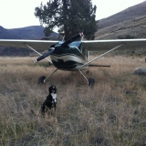
Mineral Canyon


The confluence of the Colorado and Green Rivers.


San Rafael Swell

Oops!

Mexican Mountain