Agness Approach/Departure Video
Fri Jul 28, 2023 8:08 am
Re: Agness Approach/Departure Video
Thanks tcj for the effort it takes to post things like this. I've enjoyed the information and your insights, and for creating another rabbit hole about which to learn.

Fri Jul 28, 2023 9:33 am
Re: Agness Approach/Departure Video
jcadwell wrote:Thanks tcj for the effort it takes to post things like this. I've enjoyed the information and your insights, and for creating another rabbit hole about which to learn.
Here's a time waster for you. This link will take you to the Panoramic Photos taken From the Game Lake Peak Lookout in 1934. Note the pack horses in the North View. They packed the Osbourne Transit camera that was used to take the Photos. Game Lake Peak Coordinates
Copy and paste into the search Box in Google Earth 42 25 49, -124 05 31
http://osbornepanoramicimages.blog.iamw ... k220/b.htm
Snow Camp Lookout Panoramics. Same Photographer that took the Game lake Peak Photos two days earlier.
http://osbornepanoramicimages.blog.iamw ... k590/b.htm
Link to information about the Lookout Photos and The camera. It was invented by the same Osbourne that invented the Osbourne Fire Finder still used in Lookouts today. https://www.wildlandnw.net/articles#/th ... -panoramas
Link to all the Panoramic photos taken from Lookouts in Washington and Oregon. Click on a dot on the map to see the photos.
http://osbornepanoramicimages.blog.iamw ... egion6.htm

tcj
Sun Jul 30, 2023 6:44 am
Re: Agness Approach/Departure Video
Last Night's IR flight, July 29 20:39 Hrs PDT. The The Burnout Hook is closing in on the southwest end of the fire. 25,572 Acres.

Silver Peak Lookout in 1944, built in 1940, destroyed in1968.

Silver Peak Lookout in 1944, built in 1940, destroyed in1968.
tcj
Wed Aug 02, 2023 6:37 am
Re: Agness Approach/Departure Video
IR flight last night Aug 1, 19:34 HRS PDT, 29,387 total Acres. Most of the new acres are burnout in the southwest interior using drones to ignite.

tcj
Thu Sep 05, 2024 2:29 pm
Re: Agness Approach/Departure Video
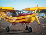
Just went in there on Monday, and wanted to share an Insta360 video of the approach. Strip is in real good shape. The Husky you see in the video is based on the field, and that pilot maintains the airstrip along with the Lucas Lodge staff. Anyway, just figured I'd upload a raw video of the approach, and the ability to see in all directions is pretty cool, if you ask me.
It looks like it might not like the 360 video being embeded, so just follow the link to view it on the youtubes.
https://www.youtube.com/watch?v=DfmWBW2craQ
It looks like it might not like the 360 video being embeded, so just follow the link to view it on the youtubes.
https://www.youtube.com/watch?v=DfmWBW2craQ
- Redtail Aviation offline
- Posts: 4
- Joined: Mon Jun 14, 2021 2:04 pm
- Location: SPRINGFIELD
- Aircraft: Zenith STOL CH-801-HD
Thu Sep 05, 2024 3:28 pm
Re: Agness Approach/Departure Video
That 360 view is cool. Do you have a video of the departure? What's typical? It seems like heading up or down any of the rivers (Rogue or Illinois) would be doable...
Mon Sep 09, 2024 3:08 pm
Re: Agness Approach/Departure Video
I will upload the departure video momentarily. On the map below I've drawn out the departure options. The first little yellow segment is about 700 ft, and due to the ski jump at the top, most airplanes are off by then. Conservative is to just head down the Illinois (green) to the southeast, where the valley opens up and there is plenty of room to turn back around. Easily doable for most airplanes is a circle up to the north (yellow) and climb through the valley. You can see by the terrain on the map below, that a right turnout down the canyon (orange/red) is turning at a pretty tight angle while climbing out, then either headed down a narrow and twisting canyon, or climbing up to get over it. Definitely doable for planes with good performance (Huskies, Supercubs, Zenith) but wouldn't try it until you really know the area, your plane, etc.

Here are a few things to keep in mind from our experience:
Here are a few things to keep in mind from our experience:
- The wind very consistently picks up in the afternoons, so approaches and departures between 1pm and 6pm should be made with extreme caution or avoided. A lot of turbulence from the terrain and the river and often a swirling cross wind. On Approach
- There is a power line that slopes away from the mountain at an angle in front of the bridge on approach. Some... helpful individuals... find it good fun to use the marker balls that are usually attached to the powerlines as target practice, so they are unmarked.
You can get a good look at them in this Google Street view (as well as a look over at the airstrip and see the slope) and also see them at 3:16 in the Approach video above. As long as you cross the bridge in the middle at a decent height (plus 20 ft), you're fine. - Don't try to hit that first 200 ft. It's a steep up hill grade, and you'll have plenty of room to stop if you touch down just as the hill rounds out. Still be aware that it is an uphill grade through much of the first half of the strip and carry just a little extra speed (3-5 knots for most planes) to help transition to the higher AOA to match the rising terrain and should help you avoid testing your gear strength, just my 2c.
- Don't carry way too much speed either. Though too much is preferable to coming up short, and there are some aspects that help you (uphill, short skijump at the top).
- There is a road crossing the airstrip at the middle (1000 ft from either end.) One collision has happened in the history of the strip, so be aware. We've had a car decide to pull out into the path and stop to watch the plane take off coming at them. Again, with the ramp at the top we were off in plenty of time, but we certainly had a bit of an issue gaining altitude until after we had buzzed just over the top of the car...
- You can park your aircraft to the left of the airstrip, either just before the road, or up to the side of the hangar. Both areas are a little rough, so be warned if you have low prop clearance, would hate for a gopher hole to ruin a perfectly good propeller.
General flying and ettiquette: - There is a lot of boat traffic on the river, and lots of powerlines crossing it as well as a pipeline just to the southwest. Please don't be "showboating" low in the canyon near the river. We get to hear about it from the locals enough as it is.
Last edited by Redtail Aviation on Mon Sep 09, 2024 3:29 pm, edited 1 time in total.
- Redtail Aviation offline
- Posts: 4
- Joined: Mon Jun 14, 2021 2:04 pm
- Location: SPRINGFIELD
- Aircraft: Zenith STOL CH-801-HD
Mon Sep 09, 2024 3:18 pm
Re: Agness Approach/Departure Video
Here's a link to the departure video. You can see at about 1:30 that we could make the right turnout down the river, we've done it, but it's a pretty tight turn into a bad angle, so you have to know that your plane can do it.

https://youtu.be/ohjSZ4n8nv8
https://youtu.be/ohjSZ4n8nv8
- Redtail Aviation offline
- Posts: 4
- Joined: Mon Jun 14, 2021 2:04 pm
- Location: SPRINGFIELD
- Aircraft: Zenith STOL CH-801-HD
DISPLAY OPTIONS
Who is online
Users browsing this forum: No registered users and 1 guest
Latest Features
-
Live to Tell
A Minnesota pilot is surprised to learn that the sudden asymmetric drag of an out-of-rig ski can…Read More -
Creators
Working in some of the Yukon's most beautiful and remote environments, photographer Simon Blakesley captures aircraft in…Read More -
Aircraft Ownership and Maintenance
Upgrading to big tires can make a huge difference in backcountry performance, but with those gains come…Read More -
Tales from Yesteryear
In this tale from bush flying yesteryear, Don Cogger signs up to help Atlee Dodge Jr recovery…Read More


Latest Knowledge Base
-
Destinations
A regional guide with ideas for winter camping destinations in California, Nevada, New Mexico, and Arizona.Read More -
Aircraft
Finding an affordable aircraft that can handle the backcountry for $80K or less? A challenge for sure, but with the…Read More -
Aircraft
01.29.2018 - Zane - Updated tire diameter graphic to add 8.50x10 Guide to tires for use in the backcountry and off-airport landing…Read More -
Pilots
12.22.2013 - Initial article format Operating aircraft on skis and negotiating a snow-covered landscape is an entirely unique skillset and environment.…Read More


