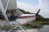
This year’s trip focus was to packraft and hike in Icy Bay, in SE Alaska (about 60 nm W of Yakata PAYA).

I flew a modified “coast” route, from Abbotsford (Canadian Customs) up the interior to the head of Bute Inlet, then to Anaheim Lake CAJ4, Terrace CYXT, Ketchikan PAKT (U.S. Customs), Petersburg PAPG, Yakutat PAYA. For the most part I flew direct courses.
Lots of VERY remote mountainous, glaciated terrain in Canada.

Numerous too-long water crossing sections once in coastal Alaska.

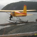
Here’s a video link (10 min long) highlighting one section of flying in Icy Bay. We camped on the beach there for a number of days. When the tide was up the water was within maybe 20’ of the tent—made for an interesting “Why do I hear waves at 2 am” the first night.
NOTE: These are 360-degree videos. Use your mouse, trackpad, tilt your mobile device or tablet, or use your finger on your mobile device or trackpad to view different perspectives.
Last year the goal was also to get to Icy Bay. Weather prevented even getting to Yakutat. This year just the opposite—absolutely perfect weather for the entire trip to/from Western Colorado.
Last year the weather was perfect in early May/June; Then seemingly continuous rain early July thru August. This year just the opposite. Go figure. Hence when people ask “What is the best time to fly to Alaska” I surmise there is no “right” answer.
Smoke made the usual views very hazy. Best visibility in Icy Bay was maybe 20 miles; In parts of Canada perhaps 15 miles.
Here are a couple of other short videos from Icy Bay. Note: These are also 360-degree videos.
We saw plenty of bear tracks. No problems or sightings at our various tent camps.

Only 1 night in a hotel (Ketchikan) the entire 2++ week trip.
I’m still going thru a bit over 1600 pictures to whittle them down to a select best-of-trip.
I’ll post updates, pictures and video links on http://fly2ak.com as well.
You can always email me at [email protected]
Thank you for your interest!
Ted