I'm headed to the Alvord Desert flyin this coming weekend, but I'll be stopping for a visit with the Oregon Star Party in the Ochoco National Forest for a couple of days first. My plan is to leave the plane in Prineville and have a buddy pick me up in his car. A quick search of the Start Party Location on Google Earth shows there is a defunct airfield called the Cold Springs Guard Landing Field about 3 miles NE of the park where the Star Party is being held. I did notice the black X in the NE corner of the field, but I wonder if anybody from Oregon knows some more history about this strip. It doesn't show up on any flight planning software, but here are the coordinates:
44 degrees, 20 minutes 34.06 seconds north, 120 degrees, 07 minutes 44.58 seconds west
Does anybody know more about the place? It appears to be part of the Ochoco National Forest, so I'll touch base with the USFS tomorrow to see if they have any feedback on the strip. If it is a viable backcountry spot, I'd walk it before trying to bring my plane in. It appears to be more than 4,000' long with mostly unobstructed approaches, so even with an elevation of over 3,000' it doesn't present much of a challenge. It sure would be convenient though! .
Cold Spring Guard Landing Station SE Oregon
Sun Aug 09, 2015 11:41 am

Sun Aug 09, 2015 2:47 pm
Re: Cold Spring Guard Landing Station SE Oregon
It's an old forest service strip that hasn't been in use for some time. It's listed on some FS maps and some of the online mapping programs but not aviation maps. You can drive right to it to inspect it and I would recomend doing that prior to landing there. I landed it a couple years ago and will not be doing it again. Lot's of big loose rocks on the surface that left me a few reminders of my visit  If you can land real slow and have 31's it shouldn't be as big of a deal?? I forwarded this strip to some of the advocacy groups as well as folks on here compiling lists of fields that could be re-opened with volunteer labor but haven't heard much of it since. I would love to see it open. I know the area up there really well! Maybe I'll catch you in or around the Prineville airport. I may be out flying monday morning.
CW
CW
- clippwagon offline
- Posts: 737
- Joined: Sun Nov 13, 2011 9:49 pm
- Location: Oregon
Sun Aug 09, 2015 3:15 pm
Re: Cold Spring Guard Landing Station SE Oregon
FWIW, it is called Big Summit Airstrip.

tcj
Sun Aug 09, 2015 3:26 pm
Re: Cold Spring Guard Landing Station SE Oregon
tcj wrote:FWIW, it is called Big Summit Airstrip.
I've only seen it listed the same as the thread title but I could be wrong. There are two others on Big Summitt Prarie that are both private. One on the east end and one on the west end. Cold Springs in on public land east of the prarie.
CW
- clippwagon offline
- Posts: 737
- Joined: Sun Nov 13, 2011 9:49 pm
- Location: Oregon
Sun Aug 09, 2015 3:54 pm
Re: Cold Spring Guard Landing Station SE Oregon
The aerial view on Foreflight lists it as Cold Spring Guard Station Landing Field. It looks like it would be a great spot to get re-opened to airplanes.

Sun Aug 09, 2015 3:56 pm
tcj
Sun Aug 09, 2015 4:11 pm
- clippwagon offline
- Posts: 737
- Joined: Sun Nov 13, 2011 9:49 pm
- Location: Oregon
Sun Aug 09, 2015 7:57 pm
Re: Cold Spring Guard Cabin Rental
Looks like you can rent the cabin. All the more reason to get the strip reopened. Link below:
http://www.recreation.gov/camping/cold- ... rkId=74163
http://www.recreation.gov/camping/cold- ... rkId=74163
Sun Aug 09, 2015 8:50 pm
Re: Cold Spring Guard Landing Station SE Oregon
Thanks all. I'll walk it while out there, but probably won't try landing there if there are big rocks. II think I'll reach out to the RAF and see if I can generate some enthusiasm over restoring the field and getting it opened again.
Clippwagon: I'll get in to Prineville at about 2:00 PM on Tuesday. I'll be back at the airport on Friday morning for the flight down to the Alvoird. I'd enjoy the chance to connect it you're in the area.
Clippwagon: I'll get in to Prineville at about 2:00 PM on Tuesday. I'll be back at the airport on Friday morning for the flight down to the Alvoird. I'd enjoy the chance to connect it you're in the area.
Sun Aug 06, 2017 9:52 pm
Re: Cold Spring Guard Landing Station SE Oregon
Did anything develop with this? Considering going to the star party later this month.
- Scolopax offline

- Posts: 1696
- Joined: Tue Sep 27, 2005 5:02 pm
- Location: Nottingham
- FindMeSpot URL: http://share.findmespot.com/shared/face ... 4aYqSexnZC
Wed Aug 09, 2017 8:54 am
Re: Cold Spring Guard Landing Station SE Oregon
i inspected Cold Springs GS airstrip in May 2017 and I would not recommend landing there. The airstrip has a large number of sizable rocks poking up through the ground. Even a bush wheeled Cub type aircraft would take quite a beating.
On a more positive note, the RAF is working with USFS to try and make some improvements at Cold Springs. Stay tuned, but have patience.
On a more positive note, the RAF is working with USFS to try and make some improvements at Cold Springs. Stay tuned, but have patience.
- Windknot54 offline

- Posts: 114
- Joined: Thu Dec 27, 2012 11:58 am
- Location: Bend
- Aircraft: Husky, Skywagon P-Ponk
Wed Aug 09, 2017 9:25 am
Re: Cold Spring Guard Landing Station SE Oregon
Good information. Thanks Windknot!
- Scolopax offline
- Posts: 1696
- Joined: Tue Sep 27, 2005 5:02 pm
- Location: Nottingham
- FindMeSpot URL: http://share.findmespot.com/shared/face ... 4aYqSexnZC
Mon Jun 01, 2020 6:43 pm
Re: Cold Spring Guard Landing Station SE Oregon
Resurrecting an old thread.
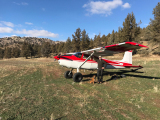
After reading this thread, I drove out to cold springs a month ago and looked it over. I drive the runway a few times and marked a strip in the best part. There are pairs of rocks painted white marking the edge. The surface consists of softball sized rocks, mostly embedded 50% or more in the hard packed dirt.
I flew back and landed a couple times in my Pacer on 8:50 X 6 tires with no issue. I approached low over the threshold and drug the runway touching down in the last 800 ft. where the surface is best. The runway is slightly uphill to the east.
There is a nice camping spot at the east end of the runway. I plan to go back and camp in the next few weeks.
https://photos.app.goo.gl/wA9e8vYySubf8L3a8
- TriPacerPilot offline
- Posts: 41
- Joined: Thu Jun 03, 2010 9:36 am
- Location: Hillsboro, Oregon
- Aircraft: PA-22/20-150, PA-24-250 Turbo
Fri Jul 01, 2022 7:57 pm
Re: Cold Spring Guard Landing Station SE Oregon
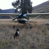
I fly into Cold Springs a few times a year in my Pacer on GY 26" and revisited again this year in my PA-12 on 35's. The strip is as rocky as ever but the camping area is in great shape. If you are thinking about going, use the east most 800 ft. as it is the smoothest. As WindKnot54 pointed out, this is not for planes with tender gear.
-
- coldsprings.jpg (181.44 KiB) Viewed 1118 times
- TriPacerPilot offline
- Posts: 41
- Joined: Thu Jun 03, 2010 9:36 am
- Location: Hillsboro, Oregon
- Aircraft: PA-22/20-150, PA-24-250 Turbo
DISPLAY OPTIONS
Who is online
Users browsing this forum: No registered users and 1 guest
Latest Features
-
Live to Tell
A Minnesota pilot is surprised to learn that the sudden asymmetric drag of an out-of-rig ski can…Read More -
Creators
Working in some of the Yukon's most beautiful and remote environments, photographer Simon Blakesley captures aircraft in…Read More -
Aircraft Ownership and Maintenance
Upgrading to big tires can make a huge difference in backcountry performance, but with those gains come…Read More -
Tales from Yesteryear
In this tale from bush flying yesteryear, Don Cogger signs up to help Atlee Dodge Jr recovery…Read More


Latest Knowledge Base
-
Destinations
A regional guide with ideas for winter camping destinations in California, Nevada, New Mexico, and Arizona.Read More -
Aircraft
Finding an affordable aircraft that can handle the backcountry for $80K or less? A challenge for sure, but with the…Read More -
Aircraft
01.29.2018 - Zane - Updated tire diameter graphic to add 8.50x10 Guide to tires for use in the backcountry and off-airport landing…Read More -
Pilots
12.22.2013 - Initial article format Operating aircraft on skis and negotiating a snow-covered landscape is an entirely unique skillset and environment.…Read More


