Backcountry Pilot • Depth, Flood, Ebb, Slack water predictions

Depth, Flood, Ebb, Slack water predictions

Information and discussion about seaplanes, float planes, and water operations.
4 postsPage 1 of 1

Depth, Flood, Ebb, Slack water predictions

Hawaii has about a 2' daily tide. Highs and lows do not require much interpretation. My sailboat at the Ala Wai harbor goes up and down with very little relative motion to the pier and of course no current.

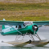
But, the rivers and bays in Oregon have a 7' foot daily tide! There is significant changes in depth and current direction. Flying my little seaplane in these brackish waters requires a little extra planning to be safe.

Here we see low tide with the flood starting:
Image

To sort out the complexity I use Garmin "Blue Water" nautical charting software to get realtime prediction on water movement:
Image
Image

Also the depths, buoys, and day markers come in handy:
Image

The airspace planning is done on ForeFlight:
Image

The very nice feature of the iPAD is I can switch between ForeFlight and Garmin "Bluewater" in the cockpit and have realtime GPS navigation in the air and on the surface.
8GCBC offline
User avatar
Posts: 4623
Joined: Thu Aug 05, 2010 11:55 pm
Location: Honolulu
Aircraft: 2018 R44
CFII, MEI, CFISES, ATPME, IA/AP, RPPL, Ski&Amphib ops, RHC mechanic cert, RHC SC— 3000TT

Re: Depth, Flood, Ebb, Slack water predictions

Cool! Now you can leave Ports & Passes at home! :D

Cary
Cary offline
User avatar
Posts: 3801
Joined: Sun Jan 10, 2010 6:49 pm
Location: Fort Collins, CO
"I have slipped the surly bonds of earth..., put out my hand and touched the face of God." J.G. Magee

Re: Depth, Flood, Ebb, Slack water predictions

You can also get a blue water chip for the 296, 396, 496 and toggle between them, which is handy. The Kachemak Bay will get 25 foot tide swings. The trick is basically to plan your trips to land at mid-tide rising.
Headoutdaplane offline
User avatar
Posts: 526
Joined: Thu May 29, 2008 5:21 pm
Location: Homer, AK
The winner is the person with the most stories when he dies, not the most gold.
www.belugaair.com

Re: Depth, Flood, Ebb, Slack water predictions

Headoutdaplane wrote:You can also get a blue water chip for the 296, 396, 496 and toggle between them, which is handy. The Kachemak Bay will get 25 foot tide swings. The trick is basically to plan your trips to land at mid-tide rising.


25' is a major tide. Very dangerous if not predicted correctly!

Thank you for the reminder, I agree with mid-rising tide arrival. Garmin multi layer charts; celestial, airspace, terrain, nautical and bathymetric are useful.
8GCBC offline
User avatar
Posts: 4623
Joined: Thu Aug 05, 2010 11:55 pm
Location: Honolulu
Aircraft: 2018 R44
CFII, MEI, CFISES, ATPME, IA/AP, RPPL, Ski&Amphib ops, RHC mechanic cert, RHC SC— 3000TT

DISPLAY OPTIONS

4 postsPage 1 of 1

Who is online

Users browsing this forum: No registered users and 1 guest

Latest Features

Latest Knowledge Base