When you import it into the app it will give you all the airstrips as waypoints, shown below as dark red circles. It's easy to add them to your flight plan and use them to navigate to.
- IMG_0053.PNG (2.4 MiB) Viewed 2879 times
When you click on a waypoint it will give you a quick summary of the GPS coordinates and other relevant information like elevation, runway length and CTAF (if applicable).
- IMG_0057.PNG (1.92 MiB) Viewed 2879 times
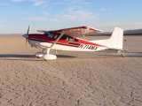
It also has a linked PDF for each waypoint. The PDF includes photos, maps, and more detailed information. Pretty much all of these are taken from Fiddler's document. It's easy to add to these, so if you have photos or suggestions, let me know.
- IMG_0058.PNG (622.14 KiB) Viewed 2883 times
The zip file is attached. Download at your own descretion. Don't edit the contents unless you know what you're doing. The format is pretty finicky, it's easy to mess up.
 California Backcountry Airstrips.zip
- ForeFlight Content Pack
- (3.01 MiB) Downloaded 552 times