The "Elkhorn Fire" in Idaho has jumped the Salmon River and grown to 10000 acres.
https://inciweb.nwcg.gov/incident-information/idpaf-elkhorn-fire?fbclid=IwAR03OLJMOzDj4mJEup3NyO5YCznskl2ab-Vh9g4BeMmUyzxjsYS9k09eojM#
Unfortunately, it appears that it has overtaken Whitewater Ranch, Yellow Pine Bar and Allison Ranch. Hoping for the best. These ranches and the surrounding forests are irreplaceable treasures. This is a tragic loss for the Idaho Backcountry.
Salmon River Canyon Fire
Mon Jul 31, 2023 10:19 am
- Scolopax offline

- Posts: 1696
- Joined: Tue Sep 27, 2005 5:02 pm
- Location: Nottingham
- FindMeSpot URL: http://share.findmespot.com/shared/face ... 4aYqSexnZC
Mon Jul 31, 2023 1:22 pm
Re: Salmon River Canyon Fire
Just down river from there was on fire last October when I was in that area elk hunting. Not far from Mackay. Huge bummer.
Mon Jul 31, 2023 2:17 pm
Re: Salmon River Canyon Fire
Josef wrote:Just down river from there was on fire last October when I was in that area elk hunting. Not far from Mackay. Huge bummer.
I was also there in October and saw that fire. It was pretty small with no TFR.
- Scolopax offline
- Posts: 1696
- Joined: Tue Sep 27, 2005 5:02 pm
- Location: Nottingham
- FindMeSpot URL: http://share.findmespot.com/shared/face ... 4aYqSexnZC
Mon Jul 31, 2023 6:06 pm
Re: Salmon River Canyon Fire
Tragic? I may have a unique view on this. Born and raised in Idaho, worked summers thru college fighting fires. A big one I was on was on the Salmon, burned 10000 acres a day for awhile. Can't even really tell where it was now. If the trees burn, they'll grow back. It's kind of a natural process there. Back in the twenties?, I think, idaho had a fire that burned three million acres. My grandpa might have been on that one.  All of it is lush forest now. If people's property burns, I'm sorry about that, but that is one of the risks you take when you buy property in Idaho forest. Hopefully, they can rebuild. Take the long view.
Wayne
Wayne
Mon Jul 31, 2023 7:20 pm
Re: Salmon River Canyon Fire
The Last Infra Red flight was Friday July 28, at 04:00 Hours PM MDT. It shows 1652 acres.

This Operations map for today was made Last night July 30, 11:04 PM MDT. The red perimeter is all unsecured fire edge. 24,174 Acres

This Operations map for today was made Last night July 30, 11:04 PM MDT. The red perimeter is all unsecured fire edge. 24,174 Acres

tcj
Tue Aug 01, 2023 6:06 am
Re: Salmon River Canyon Fire
IR Flight This morning Aug 1, 01:23 HRS, Shows accurate perimeter now, Acres burned reduced slightly to 22,361. They had done some structure protection measures in the area earlier such as setting up sprinklers on cabin roofs. We'll have to watch https://inciweb.nwcg.gov/incident-infor ... khorn-fire for a possible update on structures.

tcj
Tue Aug 01, 2023 9:39 am
Re: Salmon River Canyon Fire
Here's a link to the RAWS Remote Automatic Weather Station located at Chamberlain airstrip AKA Ranch airstrip if you're curious about the weather in the area.https://mesowest.utah.edu/cgi-bin/droma ... =0&order=1
Coordinates for locations you can copy and paste into the search box in Google Earth or Google Maps and zoom in to see the buildings and such.
Chamberlain 45 22 31, -115 11 49
Whitewater Ranch 45 31 54, -115 18 17
Yellow Pine Bar 45 32 33, -115 15 04
Allison Ranch 45 33 56, -115 13 28
Arctic Point Lookout 45 28 27, -115 02 18
River of No return Lodge 45 29 10, -114 58 34
tcj
Tue Aug 01, 2023 12:13 pm
Re: Salmon River Canyon Fire
c180pilot wrote:Tragic? I may have a unique view on this. Born and raised in Idaho, worked summers thru college fighting fires. A big one I was on was on the Salmon, burned 10000 acres a day for awhile. Can't even really tell where it was now. If the trees burn, they'll grow back. It's kind of a natural process there. Back in the twenties?, I think, idaho had a fire that burned three million acres. My grandpa might have been on that one.
Wayne
I'm with you on a lot of that Wayne. I realize that it's a natural process and that forests are surprisingly resilient and regenerative. I have seen forests miraculously come back to abundance over a relatively short period.
The tragedy, in my opinion, is the loss of historical lodges. If they go down, they will most likely never return.
Could you build out new structures on wilderness in holdings today? If so, I doubt that you could find an insurance policy covering fire damage for a lodge on the lower Salmon, which has fires every year it seems.
It is uncertain to me if any of these lodges were destroyed, but the property upon which they are built appears to have been burned through.
I have heard that Sulphur Creek lodge may be closed to the public indefinitely because of infrastructure problems that resulted from the big fire a couple of years ago.
The Minam River Lodge was threatened by a wildfire burning less than a half mile away last year. Fortunately, it is still standing.
I simply hope that the places that I have been fortunate enough to spend time at with my family and friends remain intact for others well in to the future. The loss of such places is what I would find to be tragic.
- Scolopax offline
- Posts: 1696
- Joined: Tue Sep 27, 2005 5:02 pm
- Location: Nottingham
- FindMeSpot URL: http://share.findmespot.com/shared/face ... 4aYqSexnZC
Wed Aug 02, 2023 6:44 am
Re: Salmon River Canyon Fire
IR flight last night Aug 1, 22:40 HRS MDT. 1,579 acre increase for total of 23,940 acres. most of the increase on the north edge of the fire.

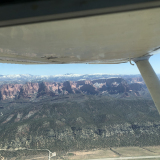
Zoomed out to see the surrounding area.

Zoomed out to see the surrounding area.
tcj
Wed Aug 02, 2023 9:40 am
Re: Salmon River Canyon Fire
Unfortunately it looks like the fire has done some damage to structures:
https://www.gofundme.com/f/fire-relief- ... 0LCrkUnXco
https://www.gofundme.com/f/fire-relief- ... 0LCrkUnXco
- highroad offline

- Posts: 778
- Joined: Wed Feb 20, 2008 10:28 am
- Location: Southern Oregon Coast
- FindMeSpot URL: http://share.findmespot.com/shared/face ... SBWeUVDhQd
- Aircraft: A Maule we call X-ray
Wed Aug 02, 2023 9:53 am
Re: Salmon River Canyon Fire
highroad wrote:Unfortunately it looks like the fire has done some damage to structures:
https://www.gofundme.com/f/fire-relief- ... 0LCrkUnXco
That's terrible news
- Scolopax offline
- Posts: 1696
- Joined: Tue Sep 27, 2005 5:02 pm
- Location: Nottingham
- FindMeSpot URL: http://share.findmespot.com/shared/face ... 4aYqSexnZC
Wed Aug 02, 2023 10:22 pm
Re: Salmon River Canyon Fire
We just rode motorcycles up Salmon River from Riggins and traversed up to top near Burgdorf. Smoke was getting thick from day before. It’s hot and dry up there.
- skyward II offline
- Posts: 447
- Joined: Sun Jul 05, 2020 9:42 pm
- Location: Upland, CA/Etna, Wy
Thu Aug 03, 2023 8:24 am
Re: Salmon River Canyon Fire
highroad wrote:Unfortunately it looks like the fire has done some damage to structures:
https://www.gofundme.com/f/fire-relief- ... 0LCrkUnXco
Im not familiar with Alison Ranch-- is there an airstrip there, lodge, campground ??

Cessna Skywagon -- accept no substitute!
Thu Aug 03, 2023 11:41 am
Re: Salmon River Canyon Fire
FYI there was no IR Flight last Night due to weather.
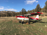
Allison Ranch Airstrip

Allison ranch buildings

Sheepeater Lookout, built in 1934 and replaced with a metal lookout in 1976
The original in 1967

The Metal Lookout still in use today

Allison Ranch Airstrip
Allison ranch buildings
Sheepeater Lookout, built in 1934 and replaced with a metal lookout
The original in 1967
The Metal Lookout still in use today
tcj
Thu Aug 03, 2023 8:41 pm
Re: Salmon River Canyon Fire
From Inciweb https://inciweb.nwcg.gov/incident-publi ... -firestorm
McCall, Idaho – August 2, 2023: In the early afternoon of July 30, 2023, the Elkhorn Fire began taking what would be by the end of the day, a 20,000-acre run of extreme fire behavior up the Salmon River. In the path of the fire were Allison Ranch and Yellow Pine Ranch. Unfortunately, seven structures at Allison Ranch and one at Yellow Pine Ranch were a complete loss, and another partially damaged at Yellow Pine Ranch.
Shortly after the morning inversion cleared, a notable increase in fire behavior took place on the south side of the river, and a substantial smoke column developed. Within minutes, the fire had crossed the river in the area of Allison Ranch where firefighters acted by using the sprinklers, pumps, and hose lays already in place at the ranch in an effort to protect the structures. Soon, another report of the fire having crossed the river at Yellowpine Ranch came in. Within the next hour, the smoke column collapsed. Firefighters who were at Allison Ranch estimated 50, then 60 and even as high as 90 miles per hour wind blowing from all directions with large burning pieces of debris flying through the air. Firefighters remained on site to provided structure protection as long as they could but had to evacuate the area due in extreme fire behavior and burn intensity. Structure protection took place at Yellow Pine Ranch as well that helped minimize the damage.
What was different this time? Fire and structure protection has taken place at ranches along the river many times in previous years. This time was the perfectly wrong alignment of fuels, terrain and weather that equated to the significant fire behavior that took place. While the loss of the structures is unfortunate, we are thankful that all firefighters and members of the public that were with them were quickly accounted for.
The Payette National Forest has a public wildfire information hotline for fire information – 208-634-0820. Visit Inciweb for information on large wildfires at https://inciweb.nwcg.gov
, and follow the Payette National Forest on Twitter at @PayetteForest, and on Facebook at U.S. Forest Service – Payette National Forest.
tcj
Fri Aug 04, 2023 7:30 am
Re: Salmon River Canyon Fire
There was no IR flight last night due to weather.
I added another RAWS station to the map. Mariah, one half mile north of White Water Ranch Ranch.
Coordinates 45 32 12, -115 18 38
Link https://mesowest.utah.edu/cgi-bin/droma ... =0&order=1
The RAWS at Ranch airstrip has gotten .05 inches of precipitation in the last 2 days but Mariah has had zero.

I added another RAWS station to the map. Mariah, one half mile north of White Water Ranch Ranch.
Coordinates 45 32 12, -115 18 38
Link https://mesowest.utah.edu/cgi-bin/droma ... =0&order=1
The RAWS at Ranch airstrip has gotten .05 inches of precipitation in the last 2 days but Mariah has had zero.
tcj
Sat Aug 05, 2023 6:57 am
Re: Salmon River Canyon Fire
No IR flight last night due to weather again. The good news is Lodge Pole RAWS (The one at Chamberlain AKA Ranch Airstrip) received 0.16 inches of rain in the past 24 Hours. Mariah received only 0.01 though. It is going to be good fire fighting weather today and the next few days with good chances of rain. Not so good for flying.
Link to the National Weather Service 'Gridpoint" forecast for The ElkHorn Fire area https://forecast.weather.gov/MapClick.p ... 3444404923
Coordinates for the Gridpoint 45.55, -115.2
Link to the National Weather Service 'Gridpoint" forecast for The ElkHorn Fire area https://forecast.weather.gov/MapClick.p ... 3444404923
Coordinates for the Gridpoint 45.55, -115.2
tcj
Sun Aug 06, 2023 4:55 pm
Re: Salmon River Canyon Fire
The Incident management team on the fire has installed a RAWS station at the Whitewater Ranch. It is an IRAWS (Short for Incident RAWS)
Link to IRAWS 33 https://mesowest.utah.edu/cgi-bin/droma ... ?stn=BGHC1
In the last 24 hours IRAWS 33 has received 0.44 inches of rain, Lodgepole RAWS at Chamberlain received .42 inches in the past 2 days and Mariah 0.37 inches. That should stopmuch fire spread for a few days.
Close up in google Earth
tcj
Fri Aug 11, 2023 7:18 am
Re: Salmon River Canyon Fire
The clouds finally cleared and they were able to make an IR flight last night, Aug 10. There was an increase of 2024 acres since the last IR flight on Aug 2nd. Total acres is now 25,964. in the last 10 days the three RAWS stations in the fire area have received approximately 0.6 to 0.7 inches of rain.
Still lots of hot spots.

Zoomed out to see the surrounding area.

Still lots of hot spots.
Zoomed out to see the surrounding area.
tcj
Fri Aug 11, 2023 7:50 am
Re: Salmon River Canyon Fire
On Inciwedb they posted a photo of a Lookout and cabin wrapped in foil. The Inciweb photo is labeled Sheep Hill. It is actually the Arctic Point Lookout.

Sheep Hill Lookout is about 8 Miles north northwest. http://www.firelookout.com/id/sheephill.html
Sheep Hill Lookout is about 8 Miles north northwest. http://www.firelookout.com/id/sheephill.html
tcj
DISPLAY OPTIONS
Who is online
Users browsing this forum: No registered users and 0 guests
Latest Features
-
Live to Tell
A Minnesota pilot is surprised to learn that the sudden asymmetric drag of an out-of-rig ski can…Read More -
Creators
Working in some of the Yukon's most beautiful and remote environments, photographer Simon Blakesley captures aircraft in…Read More -
Aircraft Ownership and Maintenance
Upgrading to big tires can make a huge difference in backcountry performance, but with those gains come…Read More -
Tales from Yesteryear
In this tale from bush flying yesteryear, Don Cogger signs up to help Atlee Dodge Jr recovery…Read More


Latest Knowledge Base
-
Destinations
A regional guide with ideas for winter camping destinations in California, Nevada, New Mexico, and Arizona.Read More -
Aircraft
Finding an affordable aircraft that can handle the backcountry for $80K or less? A challenge for sure, but with the…Read More -
Aircraft
01.29.2018 - Zane - Updated tire diameter graphic to add 8.50x10 Guide to tires for use in the backcountry and off-airport landing…Read More -
Pilots
12.22.2013 - Initial article format Operating aircraft on skis and negotiating a snow-covered landscape is an entirely unique skillset and environment.…Read More


