The next morning finds the skies in much better form. Only an hour to go and I'm home.


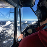
As I neared Whittier the clouds again increased but this time I could go over them and the mountains.


Whittier

Past Whittier and now looking down the Turnagain Arm.

Twenty miles of this and I'm nearly home.

Thanks everyone whom I met and those that offered advice.
Flying days went like this.
Day One planned Tucson AZ, but surrendered to weather at El Paso TX
Day Two planned and made Tucson AZ
Day Three planned and made Santa Ynez CA
Day Four planned and made Madera CA
Day Five planned Albuquerque NM, but went to Santa Fe NM because of weather. Much better choice
Day Six planned Coeur d'ALene ID but decided on Durango CO instead to recharge my energy
Day Seven planned Coeur d'ALene ID, but surrendered to weather at Lewiston ID
Day Eight planned and made Ketchikan
Day Nine planned Home, but surrendered to weather at Valdez
Day Ten planned and made Home
Total flying hours 46.5
I used Garmin Pilot mostly, but at the end was using Foreflight (that's another discussion). Transponder yes, but no ADS-B. Only flight plans filed were to cross the borders, otherwise I told friends where I was going and had them follow me on inReach.
I used the FlashPass app for filing eApis. Definitely worth it if you plan on crossing borders more than just one trip.
NavCanada persons were great as usual even with my foibles, as was Canadian customs (just a phone call). U.S. Customs was pleasant which was refreshing.
A great trip, a great route, and really enjoyed meeting everyone. Hope I have the opportunity to reciprocate sometime.