2017 Total Eclipse Map
Wed Aug 02, 2017 12:16 pm
Re: 2017 Total Eclipse Map
Copper Basin is a good one. Twin Bridges is closer to the center of the path of totality but is right next to the road from Ketchum which is expecting a huge crowd. I stop at Hollow Top all the time but as noted it is outside of totality. A lot is going to depend on weather and smoke. Even though there are no nearby fires, it is pretty smokey here in southern Idaho right now. I think it is coming from northern Nevada and California.
- CamasFlyer offline
- Posts: 12
- Joined: Wed Sep 21, 2016 7:24 pm
- Location: U86
- Aircraft: Ellis Highlander
Thu Aug 03, 2017 6:14 pm
Re: 2017 Total Eclipse Map
I looked to see where my closest point of totality approach is. Turns out it's around St Joe Missouri. I then looked around for a seemingly remote county airport to go to and found KBIE, Beatrice Nebraska, population 13,000. Called up today to see if they know an eclipse is coming and the lady told me they expect 100-200 airplanes at the airport and 20,000-50,000 people in town! Yikes. So I am still planning to head there but now I have a better idea of what I'm getting into.
They're allowing camping on the field... that's my plan. Really curious if the crowds will materialize. After all, what is there to compare it to? Nobody can say "well last year we had X."
Do I bring enough supplies to avoid the local War-Mart? Yes. Will my cell phone work? Probably not. Will it be worth it? Most definitely.

Thu Aug 03, 2017 6:30 pm
Re: 2017 Total Eclipse Map
That's my plan. Be self contained for everything and have enough fuel to get there and come all the way home if needed!
I just landed in SLC. Man it's smokey! I understand it's really smokey up in the Seattle area too. That could really put a damper on the eclipse if it keeps up!
Sent from my iPhone using Tapatalk
I just landed in SLC. Man it's smokey! I understand it's really smokey up in the Seattle area too. That could really put a damper on the eclipse if it keeps up!
Sent from my iPhone using Tapatalk
- Grassstrippilot offline


- Posts: 3536
- Joined: Wed May 31, 2006 6:17 am
- Location: Syracuse, UT
- FindMeSpot URL: https://share.garmin.com/WolfAdventures
- Aircraft: Cessna 205
Thu Aug 03, 2017 6:49 pm
Re: 2017 Total Eclipse Map
It's very smokey in Central Washington the past few days. This morning when the sun came up it looked like it does with eclipse glasses on on a clear day. Ijust looked in the direction of the sun not directly at it. I don't think the smoke is a substitute for proper eye protection to view the eclipse.

tcj
Thu Aug 03, 2017 7:57 pm
2017 Total Eclipse Map
Sorry I can't find a link to this without going through fb, but the NWS out of Boise had some interesting models forecasting smoke coverage. If someone smarter than I am can find a non-FB link...please post it!
https://www.facebook.com/NWSBoise/video ... 631473519/
https://www.facebook.com/NWSBoise/video ... 491593333/
Sent from my iPhone using Tapatalk
https://www.facebook.com/NWSBoise/video ... 631473519/
https://www.facebook.com/NWSBoise/video ... 491593333/
Sent from my iPhone using Tapatalk
- Grassstrippilot offline
- Posts: 3536
- Joined: Wed May 31, 2006 6:17 am
- Location: Syracuse, UT
- FindMeSpot URL: https://share.garmin.com/WolfAdventures
- Aircraft: Cessna 205
Fri Aug 04, 2017 7:54 am
Re: 2017 Total Eclipse Map
tcj wrote:There's a lot more to the total eclipse than just the couple minutes of totality. Even shadow snakes if you're lucky.
How to scientifically watch an eclipse.
http://iafi.org/how-to-watch-the-eclips ... every-day/
I finally got around to watching this. Wow! That was really cool! Between this and the news story last night, I'm really getting t excited for this!
Sent from my iPhone using Tapatalk
- Grassstrippilot offline
- Posts: 3536
- Joined: Wed May 31, 2006 6:17 am
- Location: Syracuse, UT
- FindMeSpot URL: https://share.garmin.com/WolfAdventures
- Aircraft: Cessna 205
Fri Aug 04, 2017 10:08 am
Re: 2017 Total Eclipse Map
I don't know where to get a set of the cool-dude 1950's-3D movie-looking eclipse glasses.
I'll probably break out my old welding hood.
That'll give the people who see me wearing it something to talk about, if nothing else.
I'll probably break out my old welding hood.
That'll give the people who see me wearing it something to talk about, if nothing else.

Cessna Skywagon -- accept no substitute!
Fri Aug 04, 2017 10:13 am
Re: 2017 Total Eclipse Map
While not as unique, the eclipse glasses can be ordered on Amazon. Lots of vendors.
Sent from my iPhone using Tapatalk
Sent from my iPhone using Tapatalk
- Grassstrippilot offline
- Posts: 3536
- Joined: Wed May 31, 2006 6:17 am
- Location: Syracuse, UT
- FindMeSpot URL: https://share.garmin.com/WolfAdventures
- Aircraft: Cessna 205
Fri Aug 04, 2017 10:17 am
Re: 2017 Total Eclipse Map
hotrod180 wrote:I don't know where to get a set of the cool-dude 1950's-3D movie-looking eclipse glasses.
I understand your desire to look cool wearing a welding hood, but I mean you can get the glasses about anywhere online, it's not like trying to find Cessna parts. The only reason not to buy some are because the sheer amount of buying options is staggering. Also, while a welding hood will probably work, it's not tailored to the brightness of the Sun, so the $3 you spend on glasses to see something that will never happen in your lifetime again where you live, seems to be worth it. Maybe not, your call.
https://www.amazon.com/s/ref=nb_sb_ss_c ... B5DFGAJ9MP
Fri Aug 04, 2017 7:43 pm
Re: 2017 Total Eclipse Map
Welding hoods will work fine IF you have a #14 filter, if you bought it for wirefeed welding it most likely has a #8 or #10 filter, many hoods for stick welding only have a #12. Oxy-acetylene goggles may have as light as a #5 filter. The advantage of a welding hood is they are usually gray or green tint, many of the eclipse glasses for sale have an orange tint.
Dale
Gravity Strikes Again.
Gravity Strikes Again.
Sat Aug 05, 2017 5:56 pm
Re: 2017 Total Eclipse Map
We ordered some of these a while ago, they seem legit: http://www.eclipse2017.org/glasses_order.htm
NASA was also handing them out for free at OSH so we ended up with a pile of them (I grabbed some, then my wife grabbed some, then my kids... By the time we achieved unit cohesion again, we had a lot). They are flimsy though, so a couple spares may not be a bad idea.
For you people flying around, make sure to get a good preflight briefing. I spoke with someone at Casper yesterday, they are anticipating local and area NOTAMS going out a few days beforehand, and special traffic routing at the more popular places. CPR is expected to have three different inbound routes, and they have assigned 15-minute landing time slots to aircraft. Airports are starting to shut down reservations due to volume, meaning pilots may not be able to land if they aren't on the list. I was told to talk to ATC enroute and file a plan, and that the tower will check my tail number against the party list. CPR, AIA, and other airports are completely shutting down for at least an hour around this thing.
ATC seems to be fully preparing for a nationwide clusterf**k that day. Get where you're going early, expect a less than direct path there, and plan to spend some time getting back. Anticipate OSH levels of crazy in some places, except with planes going to multiple airports at once. It's gonna be a blast!
Sun Aug 06, 2017 12:40 pm
2017 Total Eclipse Map
Just got back from camping in southern Idaho on a 8K foot location. SO smokey! Couldn't even see the valley floor. This morning even the trees 50 yards from the tent were hazy with smoke between us and them. I don't know what it's like up north, but I sure hope it clears out over the next few weeks! It was marginal VFR all the way back to Ogden, UT.
Sent from my iPhone using Tapatalk
Sent from my iPhone using Tapatalk
- Grassstrippilot offline
- Posts: 3536
- Joined: Wed May 31, 2006 6:17 am
- Location: Syracuse, UT
- FindMeSpot URL: https://share.garmin.com/WolfAdventures
- Aircraft: Cessna 205
Sun Aug 06, 2017 3:18 pm
Re: 2017 Total Eclipse Map
There are several large fires burning in south and east Idaho right now. They are desert fires so will likely be out soon.

Sun Aug 06, 2017 3:24 pm
Re: 2017 Total Eclipse Map
Yeah I just got home and pulled up the TFRs. I spent a lot of time fighting fire in those areas during college! Sure makes you glad to not still be doing that. Anyway, it's anyone's guess what will be happening in a couple of weeks. It's sure dry out there!
Sent from my iPhone using Tapatalk
Sent from my iPhone using Tapatalk
- Grassstrippilot offline
- Posts: 3536
- Joined: Wed May 31, 2006 6:17 am
- Location: Syracuse, UT
- FindMeSpot URL: https://share.garmin.com/WolfAdventures
- Aircraft: Cessna 205
Sun Aug 06, 2017 4:29 pm
Re: 2017 Total Eclipse Map
Grassstrippilot wrote:Just got back from camping in southern Idaho on a 8K foot location. SO smokey! Couldn't even see the valley floor. This morning even the trees 50 yards from the tent were hazy with smoke between us and them. I don't know what it's like up north, but I sure hope it clears out over the next few weeks! It was marginal VFR all the way back to Ogden, UT.
Sent from my iPhone using Tapatalk
8,000'? Don't know of anything on the sectional anyway that high..... off airport? Just curious. Which reminds me, a few weeks ago I flew into Twin Bridges and camped out (so I could get an early start the next day, it is not recommended as a camp site, near a road and no place to pitch a tent other then the end of the runway), as soon as I could see the next morning I rode 5 miles on the eMontague to the trailhead(up Trail Creek, to the road that leads to Copper Basin, then across the river, to the second trail on the left) then rode the trail I had spotted from the air last year up the mountain.
I had no idea where it went, just that it was on "my list" of places to ride after flying into, so when I eventually got up higher I was surprised to see a structure up there. I had to hike the last few hundred vertical feet as it was extremely steep and rocky, as opposed to just very steep and rocky as the balance of it was. Parts of it were pretty nice though. That's the mountains to the east of Sun Valley/Ketchum etc. in the background

Once on top, here's what I saw, the sign pretty much says it all. What you can't see is the wood stove (with wood) and misc. lawn chairs, a table, bunks, and other accouterments inside. This place is open for public use, on a first come first served basis, it is such a bitch to get to it has escaped vandalism, cool. I had failed to notice it earlier as all the other times I've flown by, I've been on the deck, usually coming out of Copper Basin after camping out
 up there. At 9500', it would seem to be a prime place to watch the event, but who knows how many people have a similar idea.
 There is also a private strip just east of Twin, and I have permission to fly into there, granted last year before this eclipse thing was scheduled (ha ha). I'm not sure if I'm going to find a totally secluded LZ spot to watch (and I have them near that area, 2 of them) or if it would be somehow more fun to be around a bunch of people, we'll see, but right now I', planning on flying over my 2 alternatives, then Twin, and make up my mind then.
- courierguy offline

- Posts: 4197
- Joined: Thu Mar 31, 2005 6:52 pm
- Location: Idaho
"Its easier to apologize then ask permission"
Tex McClatchy
Tex McClatchy
Sun Aug 06, 2017 4:32 pm
Re: 2017 Total Eclipse Map
SO smokey this morning I bagged a flight to Alpine for breakfast, I just couldn't see the point what with all the smoke. It's even worse now, short of having to get some where for a reason, I'm grounded, at least for pleasure flying. Even sitting in the house, it's like i have my head stuck in the woodstove.
- courierguy offline
- Posts: 4197
- Joined: Thu Mar 31, 2005 6:52 pm
- Location: Idaho
"Its easier to apologize then ask permission"
Tex McClatchy
Tex McClatchy
Sun Aug 06, 2017 4:51 pm
Re: 2017 Total Eclipse Map
Yeah it's pretty bad. That's really cool! I love those old lookouts. Dee and I ran to one just outside of Alpine a few years ago. They were built back in the 30s and there are a bunch of them up in the backcountry. I've marked a bunch in FF with the goal of someday flying in and hiking to them.
As for our spot, I know its blasphemy, but where we were camping was via car, not airplane. Up on Mt. Harrison south of Burley.
Sent from my iPhone using Tapatalk
As for our spot, I know its blasphemy, but where we were camping was via car, not airplane. Up on Mt. Harrison south of Burley.
Sent from my iPhone using Tapatalk
- Grassstrippilot offline
- Posts: 3536
- Joined: Wed May 31, 2006 6:17 am
- Location: Syracuse, UT
- FindMeSpot URL: https://share.garmin.com/WolfAdventures
- Aircraft: Cessna 205
Sun Aug 06, 2017 5:22 pm
Re: 2017 Total Eclipse Map
Got it, and know it well. Good day for driving!
- courierguy offline
- Posts: 4197
- Joined: Thu Mar 31, 2005 6:52 pm
- Location: Idaho
"Its easier to apologize then ask permission"
Tex McClatchy
Tex McClatchy
Fri Aug 18, 2017 11:04 am
Re: 2017 Total Eclipse Map
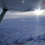
I am thinking about being in the air during the eclipse. I should be able to see the sun well enough to enjoy the moon passing over it.
My main goal is to watch the shadow hit. Over Nebraska at around 10,000 ft should give an interesting view.
Weather permitting of course.
My main goal is to watch the shadow hit. Over Nebraska at around 10,000 ft should give an interesting view.
Weather permitting of course.
- ShadowAviator offline
- Posts: 191
- Joined: Thu Feb 20, 2014 3:30 pm
- Location: Waldo
- Aircraft: 1969 C-172K "Valor"
SERVICE CEILING -noun - The altitude at which the pilot starts smacking the dash, exclaiming, "CLIMB OL' GIRL CLIMB!"
Fri Aug 18, 2017 12:52 pm
Re: 2017 Total Eclipse Map
That will be cool. I wish I could do both.
We are planning on leaving Sunday morning for either Warm Springs (first choice) or Graham. I'm really looking forward to it. I'm also looking forward to looking down on the line of cars as we are flying back home!
Sent from my iPhone using Tapatalk
We are planning on leaving Sunday morning for either Warm Springs (first choice) or Graham. I'm really looking forward to it. I'm also looking forward to looking down on the line of cars as we are flying back home!
Sent from my iPhone using Tapatalk
- Grassstrippilot offline
- Posts: 3536
- Joined: Wed May 31, 2006 6:17 am
- Location: Syracuse, UT
- FindMeSpot URL: https://share.garmin.com/WolfAdventures
- Aircraft: Cessna 205
DISPLAY OPTIONS
Who is online
Users browsing this forum: No registered users and 0 guests
Latest Features
-
Live to Tell
A Minnesota pilot is surprised to learn that the sudden asymmetric drag of an out-of-rig ski can…Read More -
Creators
Working in some of the Yukon's most beautiful and remote environments, photographer Simon Blakesley captures aircraft in…Read More -
Aircraft Ownership and Maintenance
Upgrading to big tires can make a huge difference in backcountry performance, but with those gains come…Read More -
Tales from Yesteryear
In this tale from bush flying yesteryear, Don Cogger signs up to help Atlee Dodge Jr recovery…Read More


Latest Knowledge Base
-
Destinations
A regional guide with ideas for winter camping destinations in California, Nevada, New Mexico, and Arizona.Read More -
Aircraft
Finding an affordable aircraft that can handle the backcountry for $80K or less? A challenge for sure, but with the…Read More -
Aircraft
01.29.2018 - Zane - Updated tire diameter graphic to add 8.50x10 Guide to tires for use in the backcountry and off-airport landing…Read More -
Pilots
12.22.2013 - Initial article format Operating aircraft on skis and negotiating a snow-covered landscape is an entirely unique skillset and environment.…Read More


