Backcountry Pilot • Alaska Trip June 2025

Alaska Trip June 2025

Did you fly somewhere cool, take photos, and feel like telling the tale to make us drool from the confines of our offices? Post them up!
35 postsPage 1 of 21, 2

Alaska Trip June 2025

I've always enjoyed reading the good questions, advice, and adventures of everyone here. Given the great level of experience and knowledge on this board, the bar for contributing something worthy has always seemed pretty high, although admittedly sometimes I can’t stop myself from posting anyway. Now, I have something I’d really like to share.

For years, I’ve been both inspired by and envious of all of those who have flown in Alaska, and dreamed that—someday—I would do it myself. My dream came true, ironically, when our son’s engineering internship with NAVAIR (the division of the Navy responsible for Navy aircraft) was cancelled courtesy of DOGE last March. He’s an instrument-rated pilot, and shares the love of adventure, backcountry flying, and the outdoors. The unexpected evaporation of his summer employment created an opening for us to pack up and go.

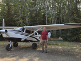
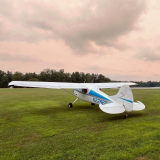
We departed on June 3 and returned home on June 27. The airplane is a 1975 U206F Stationair that I’ve owned for 21 years with a Continental IO520F. It has a Horton STOL kit, Leading Edge stainless headers, GAMIs for running LOP, Hartzell Voyager prop, 8.50 x 10 mains and an 8.50 x 6 nosewheel (AirGlas fork), nose strut bumper, and horizontal stab gravel guard.

I hope those who have lived in Alaska or made the trip to Alaska will enjoy this trip report, and that anyone who hasn’t yet made the trip will be inspired, as I was by Shaun Lunt and many others on this site. It must be experienced to be believed. What an extraordinary thing it is to live in a time and place where it is possible to do this.

We left Northern California on June 3, flew past Mt. Shasta and stopped at Prineville for fuel and to file our border crossing flight plan.

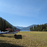
East Lake by Paulina Peak
Image

After we cleared Canadian customs at Kelowna, we flew to Prince George via the East Thompson River, Kamloops and Quesnel. The lower half of the BC interior looks like a giant tree farm, with the occasional giant mine.
Image
Image

Approaching Prince George. Loving the long evening.
Image
Image


Next morning on the way to McKenzie for fuel before proceeding up the Trench.
Image

A raft of logs coming down Williston Lake.
Image


Williston Lake goes on forever. We surprised a herd of buffalo along the eastern shore of the lake.
Image
Image

The Trench
Image

Out of the main gorge of the Trench, to the north lies Aeroplane Lake. Surreal colors, er, "colours."
Image

Fuel at Watson Lake. The obligatory hangar shot.
Image

The weather started deteriorating a little as we followed the highway towards Whitehorse. There was plenty of snow still on the ground (June 4).
Image
Image


We got fuel and overnighted in Whitehorse, enjoying the late evening along the Yukon River.
Image
Image

And now it was time for U.S. Customs. We called the night before to see if we could enter at Northway and were told that it was unlikely that there would be an agent available at Northway to clear us in the next morning, but to call again in the morning. We called in the morning at the first opportunity and the manager of the station asked how soon we could get to Northway, as there was another airplane that would be arriving around 10 a.m. The soonest we could possibly make it was 11, so he said ok. We doubled-timed it to McDonalds, and then took a taxi to the airport. Departing Whitehorse, the tower told us that we needed to have a border crossing flight plan for Canada on file in order to cross into the U.S. This was one of many times that having two pilots on board was extremely helpful. We quickly flew into really unpleasant moderate turbulence and were bucking 40 knot headwinds. No ice, but things ahead along the highway were not looking at all good.

Image

While I was flying, my son filed the flight plan with Canadian Flight Service and got us all squared away. The GPS predicted that, at the current ground speed, we would miss our arrival time by significantly more than 30 minutes if we kept to our plan of following the highway to Haines and on past Destruction Bay. The view at the window was increasingly dark and nasty, and the turbulence was more than uncomfortable. I decided to abandon the highway and cut the corner up past Aishishik Lake to Northway. That spared us the direct headwind and, after a few miles the worst of the turbulence. After a few nervous minutes, the GPS estimated our arrival time once again at 11 a.m.

We followed the Nisling River drainage for a while. The sun through the clouds showed miles of vibrant new green growth. Nothing like nearly 24 hours of daylight to make things grow.
Image
Image

The shortcut worked, and we were able to avoid scattered thunderstorms crossing the White River south of Wellesley Lake.
Image
Image
Image
Image

We touched down at Northway exactly at 11. The temperature was mild, and we were greeted by the friendliest officer by far of our entire trip. He explained that they really are extremely short-staffed, but that he was able to be at Northway due to the misfortune of another pilot who had landed at Northway the night before without having made arrangements in advance. That pilot was made to return to Canada and spend the night in Beaver, returning the next morning to Northway. The officer checked our paperwork efficiently and wished us a good trip on our way.
Image

We made the brief hop over to Tok for fuel, where we saw our first real Alaska ramp. We had come to the right place.
Image


We walked over the Fast Eddy’s for lunch, and happily relaxed knowing we were across the border and now could enjoy flexibility in our route and timing to pick our way down to Lake Hood in Anchorage. The weather in Mentasta Pass looked pretty nasty, and the pilot who had preceded us into Northway had tried to get through but had turned around to wait at Tok. After a leisurely lunch and some time studying the FAA webcams along the Glenn Highway, we decided to give it a shot. There were some squalls around the pass.
Image

It got pretty low along the highway passing north of Gulkana
Image

But then it started opening up and we were treated to a beautiful tour down the Glenn Highway past the Matanuska Glacier, and on into the Lake Hood strip at Anchorage.
Image
Image
Image

We changed the oil the next day and walked over to Point Woranzoff for some jumbo watching.
Image
Image

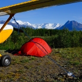
The next day, we left Lake Hood under low ceilings to fly down to King Salmon via Lake Clark Pass. There aren’t many pictures of this leg, as the weather was quite low. But between the FAA Webcams, the radio traffic with other aircraft, and ADS-B showing where they were and where they were going/coming from, we were able to pick our way to the entrance of the pass, and then on down to Lake Clark.
Image
Image

The rest of the trip down to King Salmon was under lowering ceilings, but there’s nothing to run into down there, and the views were interesting.
Image
Image
Image
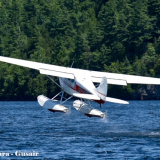
That’s our bear spray bungeed to the strut.

We spent the next 5 days fly fishing for rainbows at Naknek River Camp.
Image

This is an excellent, no nonsense fish camp with good, clean accommodations, excellent food, and serious fishing. We were right at the opening of the season for rainbows. The salmon were not in yet, and there was no evidence of bears. The fishing was on the slow side, but my son caught several terrific fish. This was a small one.
Image

And a bigger one. "What bugs?"
Image
Image

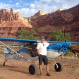
We left King Salmon on an incredibly clear and beautiful day, taking the high road at 13,500’ to Willow for fuel, then on to Talkeetna.
Image
Image
Image
Image
Image
Image
Image
Image
Image

In Talkeetna, we met up with a wonderful man—a master guide and life-long bush pilot who willingly shared his knowledge, enthusiasm, and love for Alaska and its people with us. We had been introduced through mutual connections, and had only corresponded by text to coordinate our meeting. He invited us into his home, took us on quads to visit the incredible cabin he homesteaded with his family outside of town, and shared a lifetime of experience and insight with us. I asked him to take the left seat to fly us on a tour of the Ruth Glacier and Denali environs, and he flew us on a voyage that makes IMAX seem pale in comparison. Flying Alaska with my son was the greatest trip in my 64 years. Making his acquaintance was one of the absolute highlights of our trip.
Image
Image
Image
Image
Image
Image
Image
Image
Image

From Talkeetna, we flew up the highway to Fairbanks. Along the way, we did another tour of the west side of Denali, and got a great view of the NPS repair project on Polychrome Pass on the Denali Park road. There's a huge landslide that the road crosses. For years, the NPS kept filling and grading, but with the road sinking at an astronomical rate, they finally had to close it and are in the process of putting a truss bridge in place.
Image
Image

The view north of the Alaska Range on the way to Fairbanks.
Image

The airplane campground at Fairbanks is as excellent as advertised, with clean bathrooms, showers, firewood, and outlets for recharging devices. The only drawbacks currently are the lack of bikes, which would be very useful for getting to the store, and the road noise from the nearby expressway. There are also jets departing at all hours, but hey, it's an airport! Fairbanks served as our base for explorations for the next couple of days.
Image

The next day was my day to fly, so we went east up the Salcha river, looking for strips that were mapped on Tundra Pilot to see if there were any good prospects for camping. We made a few low passes on a couple of strips, but they appeared to overgrown with saplings or otherwise in dubious condition. We kept going Northeast until we crossed over into another river drainage and arrived overhead a little airstrip, which we had also seen on Tundra Pilot. After making several inspection passes, the length appeared consistent with the 750’ noted on Tundra Pilot, the saplings didn't appear to be too tall, and the surface appeared ok. I was a little hot on landing, though, and, even with heavy braking, we used about 730 of the 750 available feet of runway. Pucker time.
Image
Image
Image
Image

The surface was also quite a bit narrower (just the width of the mains), with some ruts, and some of the saplings were tall enough to reach the wings. Fortunately, there was no damage done, other than to my ego. We spent a couple of hours with loppers and shovels from the cabin filling in ruts, moving rocks, and cutting down brush and saplings. Finally, we turned the airplane around by the tail and blasted out of there. It was a true maximum performance operation, on a narrow, rough strip, and in tight quarters that required maneuvering down river between trees immediately after liftoff. In a nutshell, the airplane will do it, but I would not do it again without more experience, and I dearly wish that I had called around to some of the local air taxis for real information on the condition of the strip before attempting it.

We then flew over to Central on the Steese Highway. This is a typical village strip, which looked like JFK after our last adventure.
Image

We got a satisfying burger lunch at the Skookum roadhouse, then took off to tour around the Yukon basin.
Image
Image
Image

The Yukon basin is an incredible expanse of wild wetland and forest. You can see the forces of nature, from floods, to fires, to massive blowdowns.
Image
Image
Image

The White Mountains north of Fairbanks.
Image
Image

We had talked with a fellow pilot at the Fairbanks campground about our desire to visit the sand dunes in Kobuk Valley National Park. As luck would have it, he flies tourists into the dunes in his 185. He generously shared his current information on landing sites and conditions, and we were all set for the next day. We took off after breakfast and soon crossed the Yukon River, landing at Rampart.
Image

It was my son’s day to fly, and he took the opportunity to sharpen his short and soft skills on a number of village strips along the way. We soon got our first view of the Brooks Range.
Image
Image

Soon, the sand dunes came into sight. My son flew a couple of low passes on the landing zone, which was conveniently marked by the tire tracks from our friend’s landings a couple of days prior. Finally, he set us up for a perfect short/soft touchdown on the sand.
Image
Image

The weather was perfect—mid ‘70s and just a light breeze. We took off our shoes and enjoyed exploring, just trying to get our heads around being above the arctic circle, barefoot in the sand, with snow drifts and ponds of ice water in the folds of the sand dunes. It is a magical place.
Image
Image
Image

After spending a couple of hours wandering and eating some lunch, we took off for Kotzebue and fuel.
Image
Image

Soon, we were seeing sea ice and the town.
Image
Image
Image

We got a big dinner at the Bison, which was the only restaurant in town that was open, then headed back to the airport for the long flight back to Fairbanks. Thunderstorms were kicking up in the Kobuk Valley, so we deviated to the south and dodged around some cells. The downbursts created gust fronts of pollen, which made a surreal sight along with the dark clouds and rainbows.
Image
Image
Image
Image

Even after such a long day, the flight back was mesmerizing.
Image

The next day, we slept in and ran some errands while thunderstorms continued to build. After taking a tour of Everts Air Cargo and hanging out at East Ramp Pizza (see the next installment), we took off around 6 p.m. with hope of finding someplace to camp in the Romanzof Range on our way to the Arctic.

Storms were building over the mountains as we approached Artic Village.
Image
Image
Image
Image

Well, I've hit the limit for photos I can download today. The best are yet to come! I hope you're enjoying the trip so far.

CAVU
Last edited by CAVU on Tue Dec 09, 2025 11:40 am, edited 6 times in total.
CAVU offline
User avatar
Posts: 659
Joined: Wed May 10, 2006 4:54 pm

Re: Alaska Trip June 2025

Wow! That has got to be the best flight report I've ever read! I have lived in Alaska my entire life, and you saw things I have never seen before. Damn! Well done, and thank you for sharing! I look forward to reading the rest once you're able to post it.
Brian M offline
Posts: 148
Joined: Sat Jun 11, 2016 10:29 am
Location: Eagle River
Aircraft: PA-18

Re: Alaska Trip June 2025

That’s the dream trip right there. Great photos. Wow!!!!
daedaluscan offline
Supporter
User avatar
Posts: 1269
Joined: Sat Jan 12, 2013 1:06 pm
Location: Texada BC

Re: Alaska Trip June 2025

Thank you for a great trip report and all of the wonderful pictures.

Lots of Alaska flight tips and customs information at https://fly2ak.com
tedwaltman offline
Contributing author + Supporter
User avatar
Posts: 345
Joined: Sat May 17, 2014 7:51 pm
Location: Lakewood
FindMeSpot URL: https://share.delorme.com/tedwaltman
Aircraft: Experimental Super Cub

Re: Alaska Trip June 2025

Thanks guys!

The next installment will come as soon as I finish the narrative part and get some more pictures uploaded.

I want especially to thank Ted for Fly2AK. The information on his website is outstanding and current. We referred to it many, many times in planning for customs. The crossings would have been much more nerve-wracking without this information. It's a great example of the value of BCP. There's so much to see and learn here, and you can take comfort in the fact that reading about it online will not diminish your experience when you live it for yourself. Again, my heartfelt thanks to ZZZ and everyone for sharing all of their travels and information.

CAVU
CAVU offline
User avatar
Posts: 659
Joined: Wed May 10, 2006 4:54 pm

Re: Alaska Trip June 2025

Hot damn, Terry. Knocked it out of the park. That’s one of the best trip reports we’ve ever had here. Nice work. Great photos too.
Zzz offline
Janitorial Staff
User avatar
Posts: 2854
Joined: Fri Oct 08, 2004 11:09 pm
Location: northern
Aircraft: Swiveling desk chair
Half a century spent proving “it is better to be thought a fool than to open your mouth and remove all doubt.”

Re: Alaska Trip June 2025

You know it’s a good trip report when it makes you feel like you need to go see the place even though you already live there.
Squash offline
Supporter
Posts: 605
Joined: Sat Nov 24, 2012 12:46 pm
Location: Alaska

Re: Alaska Trip June 2025

Great report and the plane looks awesome too!!!!!!
180Marty offline
Supporter
User avatar
Posts: 2313
Joined: Mon Jan 02, 2006 11:59 am
Location: Paullina IA

Re: Alaska Trip June 2025

Holy crap! What a great way to spend time with your son.

Pete
pburns offline
Supporter
User avatar
Posts: 475
Joined: Fri Dec 14, 2012 4:05 pm
Location: Adirondack Mt's
Aircraft: Champ 7AC

Re: Alaska Trip June 2025

Awesome TR CAVU! Thanks for sharing!
A1Skinner offline
Supporter
User avatar
Posts: 5186
Joined: Sat Jan 21, 2012 11:38 am
Location: Eaglesham
FindMeSpot URL: [url:1vzmrq4a]http://share.findmespot.com/shared/faces/viewspots.jsp?glId=0az97SSJm2Ky58iEMJLqgaAQvVxMnGp6G[/url:1vzmrq4a]
Aircraft: Cessna P206A, AT402/502/602

Re: Alaska Trip June 2025

Wow! What a trip report! Thanks for sharing!
SmokeyTheBear offline
Supporter
User avatar
Posts: 136
Joined: Fri Jul 10, 2020 6:55 am
Location: Charlestown
Aircraft: Cessna 170B

Re: Alaska Trip June 2025

tedwaltman wrote:Thank you for a great trip report and all of the wonderful pictures.

Lots of Alaska flight tips and customs information at https://fly2ak.com


Thanks Ted for maintaining that resource. Really helpful.
Zzz offline
Janitorial Staff
User avatar
Posts: 2854
Joined: Fri Oct 08, 2004 11:09 pm
Location: northern
Aircraft: Swiveling desk chair
Half a century spent proving “it is better to be thought a fool than to open your mouth and remove all doubt.”

Re: Alaska Trip June 2025

Holy mole! What a trip! And what an awesome trip report!

Thank you for taking us along. It both brought back memories and inspired me to want to go back to Alaska again! =D>
Oregon180 online
KB and Supporter
User avatar
Posts: 1259
Joined: Tue Jun 19, 2007 10:37 am
Location: Ashland
Aircraft: C180B

Re: Alaska Trip June 2025

What a great trip report. More places to add to my list. Thank you!
offroute offline
User avatar
Posts: 78
Joined: Tue Apr 15, 2014 2:52 pm
Location: Reno
Aircraft: Kitfox Super Sport Turbo SLSA

Re: Alaska Trip June 2025

Nice report so far. I hope you took a turn or three around Arrigetch peaks if you were playing in the brooks and the sand dunes. Some really cool flying out of Bettles. Arrigetch Peaks is just a place you have to see, pictures don't do them justice.
akavidflyer offline
User avatar
Posts: 521
Joined: Sat Nov 20, 2010 7:36 pm
Location: Soldotna AK

Re: Alaska Trip June 2025

akavidflyer wrote:I hope you took a turn or three around Arrigetch peaks if you were playing in the brooks and the sand dunes.


Yep. We'll get there in the next installment.

Thanks.
CAVU offline
User avatar
Posts: 659
Joined: Wed May 10, 2006 4:54 pm

Re: Alaska Trip June 2025

Ok. Time for part 2! I hope everyone had a good Thanksgiving.

We really wanted to land out away from everything and spend some time camping and exploring. The Brooks Range has captured my imagination for longer than I can remember. The Romanzof mountains were well within our reach. The weather in early to mid-June was fantastic for flying, but we were still early in terms of the melt and runoff.

After our long day, we waited out storms in the campground and at East Ramp Pizza in Fairbanks (really good pizza, with a view of the ramp and runways).
Image

We also got a tour over at Everts Air Cargo/Fuel. This is a must-do if you love round engines.
Image
Image
Image

Our friend in Talkeetna had guided all over the state for decades, and suggested a couple of remote places that we should have no trouble getting in and out of. As we flew beyond Arctic Village, the view below showed that it was still early Spring on the ground. The strips where we wanted to land were still half covered in ice and snow, the river was at flood stage, and all of the tributaries were running chocolate. But the scenery . . .
Image
Image
Image
Image
Image
Image

If there is a heaven, this is what it will look like for me.

Image


It was getting late, so we decided we had better cross over to the North Slope to see if we could find a camp site there. We crossed the range and looked back on the snowy, treeless peaks, still crowned with thunderstorms.
Image

We could see all of the way to the Beaufort Sea. The sun was still shining, of course, as we were only days from the solstice. The Arctic plain was beautiful.
Image
Image

We checked out one strip on the HulaHula River that was free of snow, but it was apparent that the winds were howling at the surface. It getting late, and that strip was more than I wanted to tackle, so we continued on to Deadhorse to see if we could get a hotel room. We had also been flying for a few hours, so knowing that we could get fuel (we had called Colville Aviation in advance) was a comfort.


In terms of range, the 206 has 80 gallon tanks. By running it lean of peak at 23 inches and 2,400 rpm, we true out at in the low 130s, and get between 10 and 11 mpg. Here’s a typical cruise setup:
Image

Not bad for a 50 year old drag queen with big tires. It also means that we can fly for more than 5 hours and still land with an hour’s worth of reserve fuel. (Oxygen and pee bottles are needed to take full advantage of that endurance.) That kind of endurance makes it easy in the lower 48, where there’s fuel everywhere. But in Alaska, where there’s no fuel between, say, Fairbanks and Kotzebue, or Bettles and Deadhorse, careful planning is still required. And there are the headwinds . . . .

We landed at Deadhorse around 10:30 p.m. The wind was howling, but very steady. We scored the last room at the Aurora Hotel. It turns out that the Yukon had taken out the Dalton Highway down near Bettles, so everyone north of the washout was stuck and almost every room in town was taken.

There was no one at the airport when we landed, so we tied down next to the Fish and Wildlife Service’s amphib and then hunted for a way to get OUT of the airport.
Image

Because it’s a 121 airport, there is serious fencing, locked gates, and locked doors everywhere, and we didn’t have a code. We ran into a similar situation in Kotzebue, where an Alaska Airlines flight was expected to land soon after we did. My son and I started walking across the ramp and were stopped by rampers who said we had to be escorted. We caught a ride in the airport pickup truck through the gate, but when we returned after dinner, no one was around so we just walked to the plane and took off.

There was no one around at 10:30 at night in Deadhorse, so we found our way around the fence and walked the half hour to the Aurora Hotel. The Aurora is pretty basic, but clean. Booties are mandatory in order to prevent the carpet from turning into muck.
Image
Room with a view.
Image

When checking out the next morning, I asked the desk clerk if we could get a ride back to the airport. She said sure, but looked confused, and asked how we got to the hotel the previous night. I explained that we had walked, and she said, “Oh. You shouldn’t have done that.” It turns out that a mama and two grizzly cubs were wandering around that part of town looking for things to eat. We’re fortunate our paths didn’t cross, as I’d left both the shotgun and the bear spray in the plane. It’s just not something I’m used to thinking about at home.

We decided to visit the village of Kaktovik at Barter Island. It was my son’s day to fly. We grabbed some extra chocolate glazed donuts from the commissary at the hotel, caught the pickup shuttle back to the airport, where there ensued a minor comedy about getting us back out to the ramp. Colville topped off the tanks, using their mammoth fuel truck as a wind break. Then we took off, did a touch-and-go, and enjoyed beachcombing for the hour+ flight.
Image
Image
Image

Homer Simpson's Flying Dream:
Image
Image

While we were flying, I noticed that the G5s in the panel were warning that there was no heading or wind direction data.
I had a moment of tech consternation, but everything else was fine. I took advantage of the InReach text capability and texted my friend back at home who is a highly experienced and practical electrical engineer, and avionics whiz. He replied with a screenshot of a section of the GTN375 manual that explains that heading data is unreliable north of 70 degrees latitude. Ah hah. Problem solved. RTFM!
Image

The headwinds were 30-40 knots on the way to Barter Island, but it was very smooth flying and we went low.
Image

The wind chill factor on the ground was significant even though the sun was warm.
Image

A Wright Air Caravan flight arrived shortly after we did, so we caught a ride into town in a van with the village agent, who was extremely helpful and friendly. He dropped us off at the town hall, where we met the mayor of Kaktovik. The warmth and kindness of everyone we met was remarkable. We were such obvious Cheekakos, and, in another time or place, it would have been easy for folks to turn their backs on us. It was just the opposite. We thoroughly enjoyed our visit and learned about the Village’s relationship with the bears (quite different for polar bears verses grizzlies), the federal government, and the history of the village.
Image
The closest we got to seeing a polar bear.
Image
Image
Image
Twelfth Street

Then we walked down to the beach to see the Beaufort Sea. My son’s Norwegian friend had insisted that he swim in the ocean, but he settled for getting knee deep.
Image
Image
Image
Image

We had walked a mile or so down the beach when we noticed someone walking towards us. We were soon joined by a friendly resident wearing a wolf’s head hat (it was cold in the wind).
Image

She asked about our travels and told us stories of growing up in Kaktovik--fishing along the arctic coast, the annual hunts up into the Brooks Range, games they played as children before technology came to town. One game, in particular, involved juggling and balancing a stick with a nail or spike in the end of it, with increasingly complex variations of the gyrations, and graduated score-keeping. She explained that this game and many others were great social pastimes growing up, but that the internet and video games have taken their place. Other major changes came with the creation of the ANWR. It was fascinating. I think of my grandparents, who were born before the invention of powered flight and lived to see the moon landing. Our friend in Kaktovik may have been born in the 'early '60s, but arguably has lived through an even greater transition.

The polar bears were still out on the ice, so we were not too concerned about encountering one. She did tell us, though, to keep an eye on the ice, and, if we saw anything that seemed to move, to pay attention and get out there. Her advice on polar bears if we encountered one was to act big and bluff. I’m glad I didn’t get to test that out.

After grabbing tacos for dinner at the town hotel, we walked back to the airport, and took off.
Image
Image
Image
Image
Image

There was another spot not too far from the Dalton Highway that our Talkeetna friend had recommended for camping, so we wanted to check that out. First, though, we had to stop by Kavik River camp, because we wanted to, and because the unexpected headwinds on the way to Barter Island had eaten substantially into our fuel. The wind was howling at Kavik River Camp, but the runway is huge and the wind was down the pipe. One complication was that the gravel connector taxiway between the runway and the ramp and fuel pump had washed out.
Image

No problem. The friendly folks at the camp met us in the Sherp and took us across the wash to camp.
Image

¿Quién tiene los tires más grandes?
Image
Image
Image
Chena Hot Springs monster truck

We had a nice visit and then took 20 gallons of avgas back over to the plane.
Image

The wind was rocking the wings vigorously, and that made getting the fuel into the tanks a bit of a challenge. Then we made a very short takeoff into the wind and headed towards the spot nearer to the Dalton Highway to see if it was clear enough to land and camp.
Image
Image
Image

It was and it wasn’t--at least for us. It was clear enough that the owner/operators of the nearby hunting camp were there in their Supercubs, but the 206 strip was still under water and ice.
Image
Image

After a couple of circles and longing looks out the window, we decided to head back to the south side of the Brooks Range to find a dry place to camp with—hopefully—less wind.

We followed the haul road and enjoyed another passage through the mountains. Atigun Pass is really more of a notch than a pass. I wondered why the haul road wasn’t built up the John River to Anaktuvuk instead of up and over Atigun, but we got a pretty good idea a few days later when we flew the route from Anaktuvuk to Bettles. The weather was great, so we had no difficulty following the haul road to Wiseman.
Image
Image
Image
Image
Image
Image

Wiseman is a classic backcountry/village camping destination. It’s surrounded by trees, down by a river, and close to a little settlement. It reminds me a little of Warren, Idaho. There are no services (except for the phone), but it’s a very pleasant place to camp, and the strip had recently been cleared of saplings.
Image
Image
Image

We’d been running on sunlight and adrenalin for about 2 weeks, with very little sleep, so we took a rest day in Wiseman, enjoyed a long walk, a couple of naps, a dip in the creek, and the quiet. We also did some brushing-out around the wind sock and finished cutting saplings around the runway end markers.
Image
Image
Public phone
Image
Image

After our rest day, we took off for Anaktuvuk Pass.
Image
Image
Image
Image

Right base, landing to the North
Image

We did not see much living wildlife on our trip, but we did see evidence of it
Image
Image

We walked around the town and bought some groceries, then took off to fly down the John River to Bettles.

Anaktuvuk river departing the village
Image

We topped the tanks at Bettles, then took off to fly around the Arrigetch Peaks. We had hoped to land and camp at a bar near the confluence of Arrigetch Creek and the Alatna River, but the water was too high. We had a great view of the Brooks Range in Spring and made a few turns around the highest of the peaks.

Image
Image
Image
Image

After a few circuits, we decided to return to Fairbanks for a shower. In fact, there were quite a few showers and thunderstorms around the White Mountains and Fairbanks area.
Image
Image
Image

SEATs were fighting the fires close to town, dipping in the Fairbanks float pond
Image

One reason we went north from Fairbanks was that the temperatures were downright hot there, with highs above 90, and lows at night just barely cool enough to sleep under a sheet. The heat wave continued, but the lightening fires started by the thunderstorms we’d witnessed a few days earlier on our way from Kotzebue to Fairbanks were starting to make a lot of smoke. Between the smoke and the heat, we decided it was time to head south.
Image
Image
Image

The next morning, we broke camp and headed back to Talkeetna to meet up with our friend for lunch. Along the way, we saw a large fire burning to the west of Healy.
Image

Headwinds (again!) made for a slow and rough flight back to Talkeetna, but once we were there, the sun was out and we enjoyed the good company of our friend and shared some more tales.
Image
Image
Image

Then we headed south to look for another camping spot. I hadn’t given up on fishing, but the rivers in the whole Mat-Su basin were all in flood stage and out of their banks. We checked out the Nakotchna strip and the strip near Lake Creek Lodge, but the water was too high for fishing. We landed at Skwentna and set up a buggy camp by the runway where there was a bit of a breeze to keep the ‘skeets away.
Image

As you can see, we didn’t spare much on the camping gear, having brought the Coleman stove, folding table, chairs, cots for sleeping, and the big tent. Luxury camping is great, as long as you don’t have to move too often.

After breakfast the next morning, we took off and flew low and slow with the windows open. The temperature was balmy—in the mid-70s, and the breeze got rid of most of the bugs that had infested the inside of the plane. (Just yesterday, I wiped up multiple Alaska mosquito corpses still stuck in the oil sheen on the motor mount structure inside the cowl.) I’ve never flown in a cub on a calm warm evening before, so this is as close as I got. We were getting close to the end of our trip, so we started planning our return.
Image
Image
Image

We stopped at Palmer for fuel and lunch, then headed up the Glenn Highway and then cut over to the Richardson Highway for Delta Junction. Along the way, my son took us for a tour up the Matanuska Glacier before heading up the highway. An embarrassment of riches:

Image
Image
Image
Image
Image
Image
Image
Image
Image
Image
Image

We got a good view of a southern segment of the pipeline on the way into Delta Junction.
Image
Image

Lodging was modest. The temperature was still in the 80s when we arrived. All of the restaurants were closed, so we went to the well-stocked supermarket and foraged for supper and breakfast.
Image

The next morning was smokey. Thank goodness for Class G. We flew down the road from Delta to fuel again at Tok Junction, then on to Beaver in Canada to clear Canadian Customs.
Image
Image

We were careful to fly around and outside the control zone at Northway. It was raining when we landed at Beaver, so we sat in the plane and made our phone calls. Customs was somewhere back in Ontario, and they were having a hard time finding a record of our ever having cleared through Canada. The shotgun, again, was a particular attraction. Fortunately, we had both registered it with U.S. Customs before our departure, and had the receipt from Kelowna with a report number on it showing that we had paid our fee and properly declared the Remington. It took close to an hour to sort all of this out, and we were finally cleared and released to continue on our way. When we went inside the flight service station at Beaver, the nice lady there told us we could have left the airplane and come inside to do all of our phone calls in more comfortable surroundings. Noted for the next trip.

The weather improved as soon as we left Beaver, and we enjoyed fine views of Kluane Lake following the highway to Whitehorse.
Image
Image

We had enough fuel to make it to Watson Lake without stopping, so we flew on. The weather was starting to deteriorate again and we encountered some rain along the way. As we crossed the last ridge to the west of Watson Lake, we noticed a gaggle of 6 or 7 airplanes on ADS-B heading west towards us. It looked like a small armada on the screen. It turns out it was a popular social media pilot and his buddies on their way to play in Alaska. We exchanged pleasantries and some weather info and went our separate ways.
Image

After fueling at Watson Lake, we headed down the Trench. At Watson Lake, our helpful briefer from Canadian Flight Service cautioned us that there were numerous storms along our route to McKenzie. They don’t have any radar for that area, but they have satellite, and the view out the windscreen confirmed his read on the situation.
Image
Image

We made it past Chee House and Aeroplane Lake, almost to Fort Ware, before there was an ominous, ugly darkness that extended all of the way to the ground where the real Trench began. Things looked better to West, though. We were fat on fuel, so we turned West and climbed up over some of the most rugged and trackless country of our trip.

Image
Image
Image

We were hoping to make an end-run around the storm and land at McKenzie, but wound up heading over to Smithers. There was only one proper airstrip between the Trench and the Smithers area. We could have landed there if we got completely shut down. If the weather behind us remained clear, though, our Plan C was to turn back to Watson Lake. Fortunately, neither was necessary. It was late and full dark by the time we got to our hotel room. All of the restaurants were closed (notice a pattern?) so we bought microwave burgers at a gas station and called it a night.

Down at Smithers
Image

The weather was already down when we woke the next morning, so we took our time to file our eAPIS and make phone calls for clearing into U.S. Customs at Dorothy Scott airport. We were able to follow the highway low through rain showers until things cleared up enough to go direct to Williams Lake. We needed to update our arrival time at least 2 hours before crossing the border. My son had a strong cell signal on his phone approaching Williams Lake and was able to talk with the U.S. Customs officer who would meet us. I was dodging rain cells and was preparing to call the Mandatory Frequency for the remote tower to transit the Williams Lake airspace. The customs officer said he couldn't find any record of our eAPIS filing. My son fortunately had a screen shot of it, including the number, and that was enough to get to the next step. Which was . . . the shotgun! I was about to penetrate the Mandatory Frequency airspace at Williams Lake when the customs officer asked my son for the registration number for the shotgun, so I made a hard right to avoid the airspace while we dug through the pockets in our binder to get the Canadian and U.S. numbers. Considering that we didn’t see a single live bear on our entire trip, I am inclined to leave the Remington at home the next time we head north in June. Then again, if we had been able to camp on the north slope or in the Brooks Range, I wouldn’t have wanted to be there without both the bear spray and the lead sprayer.

Back to the tree farm
Image

We landed at Dorothy Scott on time. We had to dig out the shotgun for inspection (it was on the floorboards at the bottom of the pile). Our customs officer chided us for putting Spokane down as our port of entry. But the fact is that the U.S. Customs website will not accept any identifier for Dorothy Scott as a port of entry. The identifier for Dorothy Scott 0S7. Customs insists that it’s “K0S7.” We had tried to enter both while we were in Canada—both on the ground in Smithers and in the air by Williams Lake, but the web site will accept neither. Hence, the closest point of entry was Spokane. Fortunately, we had a record of our eAPIS filing handy, there was good cell reception at Williams Lake, and there were two of us--one to fly the plane and one to wrangle the paperwork.

We topped the tanks again at Omak and headed off into the sunset to spend the night in Oregon. We landed in full dark at Redmond, and made it to a restaurant in Sisters just before closing time for a beer and hot meal.
Image
Image
Image
Image
Image

Image

Scratching the Surface

It’s impossible to capture in words how much I loved this trip. The people were wonderful. Every day was new and exciting. The flying was great. The views were incredible. It was clear from the moment we crossed the border Northbound that we were flying over such a great expanse of wild country that one lifetime is not enough to get to explore and get to know it. As our friend in Talkeetna told us, “Next time, come back and spend some more time on the ground and get to know the people and the places.” Sound advice. I intend to take him up on that.

Image

Last, but not least, I am eternally grateful for my wife, who supported and encouraged this "boys' trip," and served as mission control monitoring our InReach and texts, and for our son, whose inner strength and character are as fine as everything we saw and experienced together, in and above the Great Land.


Terry/CAVU
Last edited by CAVU on Wed Jan 07, 2026 4:01 pm, edited 12 times in total.
CAVU offline
User avatar
Posts: 659
Joined: Wed May 10, 2006 4:54 pm

Re: Alaska Trip June 2025

The 2025 BCP award for best trip report goes to :wink: , it's epic. =D>
Mapleflt offline
Supporter
User avatar
Posts: 2324
Joined: Sun Feb 12, 2017 2:35 pm
Location: Bradford
Aircraft: Cessna S170B NexGen (NM) Variant

Re: Alaska Trip June 2025

So good, Terry! I for one really appreciate the careful thought that went into the storytelling.

I hope this inspires others to submit their own TRs. You just have to want to tell a story. Feel free to PM or email me for guidance if you feel so inclined.
Zzz offline
Janitorial Staff
User avatar
Posts: 2854
Joined: Fri Oct 08, 2004 11:09 pm
Location: northern
Aircraft: Swiveling desk chair
Half a century spent proving “it is better to be thought a fool than to open your mouth and remove all doubt.”

Re: Alaska Trip June 2025

Fantastic trip report, thanks for sharing the story! Thanks as well for stoking the fire on the fact that I gotta get up there with my dad as well.
DreadPirateWill offline
Supporter
User avatar
Posts: 101
Joined: Wed Dec 06, 2017 10:40 am
Location: Spokane

DISPLAY OPTIONS

Next
35 postsPage 1 of 21, 2

Who is online

Users browsing this forum: No registered users and 0 guests

Latest Features

Latest Knowledge Base