I have 100 acres of dry ground around my house that we just use for range ground for some sheep, and I’d like to grade out a dirt airstrip. It’s overall a half mile east-west and about 1,950 north-south, with fence all around it and a power line on the south and west edges.
Obviously the longest runway would be generally east-west, but that’s the way it’s least flat. There’s probably a 20’ rise as you move from the west edge to mid point, and 15’ of fall from midpoint to the east. North-south it’s flat on the east and west edges, and rolling terrain through the middle.
I think my longest line (red) that’s nearly flat would be 2,070’ from power line to fence, according to google earth. It can likely be graded to within a foot or two elevation difference from end to end. It’s over a half mile to be near any houses close to the extended centerline.
Next best flat-ish possibility (blue) would only gain about 100 more feet of length, with the added disadvantage of a neighbors house only being a couple hundred feet off the extended centerline, 1,200 feet beyond the fence. It’s probably within a 10’ elevation range from end to end.
The longest passable(?) line (green) is about 2,800 feet long and would go right over the rise and fall described earlier. I am concerned that sheep could be really hard to see over the rise if they get on the runway, and the terrain could make for some pretty roller-coastery takeoffs and landings.
Given all that, which line would you favor?
How concerning is the power line at the end of any possible runway? I think it could get very expensive to try to get a line buried. How much useable runway length do you figure is lost to cross over a power line?
According to the county it’s going to be about $2,500 in permits, and though I can do the grading myself, that’s also not free, so I’d like to make a strip I can be happy with on the first try.
Let me know what you think.
Siting an airstrip: longer vs flatter
Sat Feb 04, 2023 2:16 pm
Siting an airstrip: longer vs flatter
-
- C4400AEE-514A-4E13-82AE-702FB687F8C1.jpeg (506.99 KiB) Viewed 2601 times
Last edited by BigBen on Sat Feb 04, 2023 4:48 pm, edited 1 time in total.
Sat Feb 04, 2023 4:07 pm
Re: Siting an airstrip: longer vs flatter
What altitude are you at there? What kind of density altitude in the summer? What kind of plane are you flying with what kind of load in it?
The airport I got my ppl at only had a 2000 foot runway, everything got in and out easily, and that's with power lines, buildings and busy streets on each end. I think you probably have lots of length there any way you orient it. Which way is the prevailing wind?
The airport I got my ppl at only had a 2000 foot runway, everything got in and out easily, and that's with power lines, buildings and busy streets on each end. I think you probably have lots of length there any way you orient it. Which way is the prevailing wind?
- Fraser Farmer offline
- Posts: 388
- Joined: Tue May 13, 2014 10:38 pm
- Location: Abbotsford
- Aircraft: 1977 Cessna 185
Sat Feb 04, 2023 4:47 pm
Re: Siting an airstrip: longer vs flatter
Fraser Farmer wrote:What altitude are you at there? What kind of density altitude in the summer? What kind of plane are you flying with what kind of load in it?
The airport I got my ppl at only had a 2000 foot runway, everything got in and out easily, and that's with power lines, buildings and busy streets on each end. I think you probably have lots of length there any way you orient it. Which way is the prevailing wind?
Elevation is about 1260’. Density altitude in the summer can be thousands of feet high in the afternoons when it’s hot, but it cools off significantly overnight. Should be a chance to take off at 2,000’ or less DA most mornings.
I have a Cessna 175 that’s within a couple hundred pounds of gross with just me and full fuel (I’m about 310#). If I came in to a bunch of money tomorrow I think I’d be shopping for a 206. Maybe a 205 if I only came in to a more modest amount of money…
Prevailing wind is from the SW.
I’ve been a little spoiled with runway length, learning to fly at MWH first and then EPH recently. The short runways are 3,300’ or more with nothing, taxiway, or old, unmaintained pavement for a couple thousand more feet. It’s pretty hard to run out of runway, to say the least. I’ve really been focusing on keeping landings short, figuring I’m eventually going to be flying places where you don’t have 5,000 to 13,000 feet to work with. Hot weather takeoffs, of course, are what will demand the most length.
Sat Feb 04, 2023 5:58 pm
Re: Siting an airstrip: longer vs flatter
A major consideration, with family, is how close is the larger airport to load family? From a single pilot or crop duster point of view, wires in open country like yours are usually safer to go under rather than over during high density altitude times. A sheep fence is not a big consideration, but requires a bit of extra runway. Another major consideration on uneven ground is where you are getting into low ground effect and if low ground effect can be maintained when overflying the hills in the runway. Once to the end of whatever runway, down drainage egress is a major consideration. A 175 is nearly a 182 in takeoff performance and your ground is fairly smooth and open. Practice some form of power/pitch deceleration to be able to touchdown slowly and softly on the numbers consistently at the big airport. Practice hover taxi down the long runway and rudder turns, with cross controlled aileron to keep the wing level, from one side of the runway to the other. Practice zoom climb from fairly slow in low ground effect flight to jump obstructions. Either the rudder turn around or the short zoom climb followed by a soft field type return to low ground effect can safely miss animals or unexpected obstructions. The big issue with spray strips and farm strips is technique not engine power. Technique can be practiced safely on long runways.
With hills, culverts or regrading high water ditches come into play. The culvert need not be runway wide if good rudder and ground effect technique is learned first. Narrow runway practice would be necessary if there was need to roll over the culvert.
With hills, culverts or regrading high water ditches come into play. The culvert need not be runway wide if good rudder and ground effect technique is learned first. Narrow runway practice would be necessary if there was need to roll over the culvert.
- contactflying offline
- Posts: 4972
- Joined: Wed Apr 03, 2013 7:36 pm
- Location: Aurora, Missouri 2H2
Download my free "https://tinyurl.com/Safe-Maneuvering" e-book.
Sat Feb 04, 2023 6:31 pm
Re: Siting an airstrip: longer vs flatter
Every year I clear a huge pond hockey rink and then spend an inordinate amount of weekend hours maintaining twice as much ice as what I could actually get by with. Sometimes less is more. Somehow I keep putting in a huge rink every year though  . YMMV.
-DP
. YMMV.-DP
Last edited by denalipilot on Sat Feb 04, 2023 7:14 pm, edited 3 times in total.
- denalipilot offline


- Posts: 2789
- Joined: Mon Oct 15, 2007 4:53 pm
- Location: Denali
- Aircraft: C-170B+
Sat Feb 04, 2023 6:45 pm
Re: Siting an airstrip: longer vs flatter
contactflying wrote:A major consideration, with family, is how close is the larger airport to load family? From a single pilot or crop duster point of view, wires in open country like yours are usually safer to go under rather than over during high density altitude times. A sheep fence is not a big consideration, but requires a bit of extra runway. Another major consideration on uneven ground is where you are getting into low ground effect and if low ground effect can be maintained when overflying the hills in the runway. Once to the end of whatever runway, down drainage egress is a major consideration. A 175 is nearly a 182 in takeoff performance and your ground is fairly smooth and open. Practice some form of power/pitch deceleration to be able to touchdown slowly and softly on the numbers consistently at the big airport. Practice hover taxi down the long runway and rudder turns, with cross controlled aileron to keep the wing level, from one side of the runway to the other. Practice zoom climb from fairly slow in low ground effect flight to jump obstructions. Either the rudder turn around or the short zoom climb followed by a soft field type return to low ground effect can safely miss animals or unexpected obstructions. The big issue with spray strips and farm strips is technique not engine power. Technique can be practiced safely on long runways.
With hills, culverts or regrading high water ditches come into play. The culvert need not be runway wide if good rudder and ground effect technique is learned first. Narrow runway practice would be necessary if there was need to roll over the culvert.
It’s 6 nm north to an airport with good long runways, avgas, and IAs.
The wires at the end of the runway would not be ones to go under… terrain slopes up slightly to the road, and with the newly added fiber optic cable below the original wires, there’s not much air between it and the top of the fence. I’ll attach a picture near the end of the red line looking southwest.
I’ll take the point about difficulty maintaining low ground effect over varying terrain as a vote for the flatter path. I’m getting much better at hitting the numbers and stopping shorter at the bigger runways. I can usually be full stop by the touchdown marks without having to romp on the brakes very hard.
I’m not familiar with what “hover taxi” is, you might have to expand on that thought.
We’re too dry to need to give much thought to culverts or ditches. When snow accumulation is melting and while the frost is coming out of the ground things can get too wet/soft to be fit for use for a week or three, but the rest of the year our dirt can be about as firm as a paved road so long as it’s packed well when there’s a little moisture and it’s not driven to a powder when it’s dry.
Sat Feb 04, 2023 7:50 pm
Re: Siting an airstrip: longer vs flatter
When you decelerate on short final until the sink brings the throttle into dynamic play to direct glide angle and rate of descent to the numbers, you will have some power at the flair (no round out needed). Add just a bit more power just before touchdown and use dynamic elevator to just stay off in low ground effect. Rudder only to keep the centerline between your legs and power adjustment to keep from touching down or to keep from climbing out of low ground effect, but once power is right it will only take dynamic proactive elevator to bracket low ground effect. Reduce power to touch down where you please and roll a bit to stop without brakes.
- contactflying offline
- Posts: 4972
- Joined: Wed Apr 03, 2013 7:36 pm
- Location: Aurora, Missouri 2H2
Download my free "https://tinyurl.com/Safe-Maneuvering" e-book.
Mon Feb 06, 2023 6:42 am
Re: Siting an airstrip: longer vs flatter
Once you are really comfortable with hover taxi, it can be used to evaluate the best runway heading at your strip. Just bring the airplane into hover taxi near the beginning of the proposed runway over the scrub and tumbleweed and then accelerate in plenty of time to make the fence or wire at the end. It will give you a feel for how much the hilliness will affect the takeoff once in low ground effect and what actually works out best for egress. Remember that there is never any need to get up fast or overfly obstructions by more than just a few feet. Over the vegetation there, you will be at about a five foot ground effect. That is not as energy producing as is a foot or even six inches ground effect over smooth ground or runway.
- contactflying offline
- Posts: 4972
- Joined: Wed Apr 03, 2013 7:36 pm
- Location: Aurora, Missouri 2H2
Download my free "https://tinyurl.com/Safe-Maneuvering" e-book.
Mon Feb 06, 2023 7:32 am
Re: Siting an airstrip: longer vs flatter
How close to the center is the hump on the north edge? and where is the nearest obstacle to the east of that edge. With no wire on the eastern boundary, and a better approach, if the 'hump is centered, you have a quarter mile of uphill to get it stopped, with another quarter mile of downhill 'overrun'. I'd take clean approaches, no neighbors to pass at full throttle on take off, and wires farther off the departure end than a few hundred longer feet of ground run every day. If the rise is centered, you'll have what amounts to two 1/4 mile E-W strips with 1/4 mile over runs.
My 'home' strip is a quarter mile end to end, with reasonably tall brush on both ends, and a levee shortly after that. All the planes you list have been in it, and most of them use half to get shut down or off the ground.
Take care, Rob
My 'home' strip is a quarter mile end to end, with reasonably tall brush on both ends, and a levee shortly after that. All the planes you list have been in it, and most of them use half to get shut down or off the ground.
Take care, Rob

Mon Feb 06, 2023 9:43 am
Re: Siting an airstrip: longer vs flatter
If you use the term "hover taxi" in reference to fixed wing operations in a mixed crowd of aviators the swing wing gang are going to think you've been self-medicating. They might even go “Bob Hoover” on your hinny and call in the Ferderallies.
Mon Feb 06, 2023 10:26 am
Re: Siting an airstrip: longer vs flatter
"Slow as possible in low ground effect" is awkward to say.
- contactflying offline
- Posts: 4972
- Joined: Wed Apr 03, 2013 7:36 pm
- Location: Aurora, Missouri 2H2
Download my free "https://tinyurl.com/Safe-Maneuvering" e-book.
Mon Feb 06, 2023 10:57 am
Re: Siting an airstrip: longer vs flatter
Ephrata? I'd give pretty strong consideration to which direction is into the wind.
Second to that would probably be clear approaches for me. There's a strip at my folks place with a similar power line on one end, touchdown zone is about 500' past the line. Plenty of clearance, but it certainly eats in to the distance available. Much nicer when you can bring it in a bit flatter with more margin. You might ask GCPUD about undergrounding, even though it's 3 phase they may be able to plow it in there. It won't be cheap, but should be cheaper than a bent airplane.
Third on my ranking would be terrain. Certainly flatter is better, if there's an obstacle where I can't see critters I'm landing before or after it.
That said, living at the airstrip is the best aviation investment I've made hands down. Luckily for me the home strip is 2500' with clear approaches so I can pretty much fly anything I can afford any day. Balance that against Greg Miller's home strip where I wouldn't even fly a kite. Different risk tolerance I guess.
https://www.youtube.com/watch?v=oCUtlSfGtCI&t=963s
- DreadPirateWill offline
- Posts: 101
- Joined: Wed Dec 06, 2017 10:40 am
- Location: Spokane
Mon Feb 06, 2023 7:46 pm
Re: Siting an airstrip: longer vs flatter
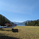
- home.png (1.24 MiB) Viewed 2184 times
I only had one area where I could put in my strip due to wetlands (highly protected) and terrain. Mine is similar to yours as far as a rise in the middle.
Not as much as you (10'+/-). The predominate direction for runways in my area is 13/31 meaning the winds are mostly out of the northwest. My strip orientation in Northeast/Southwest which means I deal with nearly 90 degree crosswinds frequently. Both ends of my strip are tall pine trees with the SW end having a hill with century old pines, almost perfectly aligned with the strip, when landing to the NE.
I'm thinking, if you are comfortable and proficient in your plane, all of your choices are do able. Go find a place with similar terrain and practice with the plane in the configuration you normally fly. That's what I did before the first landing on my strip. I had zero problems landing in about 1/3 of a 2000' strip and that was not trying to land as short as possible, just a leisurely average landing. I'm very comfortable with the plane having flown it over 30 years.
Last edited by WWhunter on Mon Feb 06, 2023 8:26 pm, edited 1 time in total.
Mon Feb 06, 2023 8:26 pm
Re: Siting an airstrip: longer vs flatter
Rob wrote:How close to the center is the hump on the north edge? and where is the nearest obstacle to the east of that edge. With no wire on the eastern boundary, and a better approach, if the 'hump is centered, you have a quarter mile of uphill to get it stopped, with another quarter mile of downhill 'overrun'. I'd take clean approaches, no neighbors to pass at full throttle on take off, and wires farther off the departure end than a few hundred longer feet of ground run every day. If the rise is centered, you'll have what amounts to two 1/4 mile E-W strips with 1/4 mile over runs.
My 'home' strip is a quarter mile end to end, with reasonably tall brush on both ends, and a levee shortly after that. All the planes you list have been in it, and most of them use half to get shut down or off the ground.
Take care, Rob
The top of the hump on the north is about in the middle of the property. It drops off pretty fast to the west so the NW quadrant of the property is generally flat. From the high point going east along the north edge, the fall is more gradual and somewhat rolling depending on just what line you take.
On the east edge there’s the fence, an undeveloped road ROW, a large irrigation canal, then a half mile to one house, then nothing else for miles.
It does sound more appealing to say “two 1/4 mile air strips with 1/4 mile overrun areas” than so say “a half mile airstrip with a bigass hill in the middle of it.”
Mon Feb 06, 2023 8:46 pm
Re: Siting an airstrip: longer vs flatter
DreadPirateWill wrote:Ephrata? I'd give pretty strong consideration to which direction is into the wind.
Second to that would probably be clear approaches for me. There's a strip at my folks place with a similar power line on one end, touchdown zone is about 500' past the line. Plenty of clearance, but it certainly eats in to the distance available. Much nicer when you can bring it in a bit flatter with more margin. You might ask GCPUD about undergrounding, even though it's 3 phase they may be able to plow it in there. It won't be cheap, but should be cheaper than a bent airplane.
Third on my ranking would be terrain. Certainly flatter is better, if there's an obstacle where I can't see critters I'm landing before or after it.
That said, living at the airstrip is the best aviation investment I've made hands down. Luckily for me the home strip is 2500' with clear approaches so I can pretty much fly anything I can afford any day. Balance that against Greg Miller's home strip where I wouldn't even fly a kite. Different risk tolerance I guess.
https://www.youtube.com/watch?v=oCUtlSfGtCI&t=963s
Strong winds are generally from the SW, so no lines on my sketch are directly crosswind. In the winter the wind will blow out of the north more. The blue line probably best for warm season wind alignment, and the red line best for winter.
I can ask PUD about burying the power line, but I’m not optimistic about the price, given what I’ve seen materials cost do in the last couple years. I was hoping not to spend too awful much on this project, especially since if they ever grant me irrigation water on this property it’ll probably be the end of this airstrip.
Thanks for the 500’ number, that’s useful for estimating how landing over the power lines would go.
Mon Feb 06, 2023 9:19 pm
Re: Siting an airstrip: longer vs flatter
WWhunter wrote:I was flying an O-300 powered 172A in and out of my strip which is around 1600' end to end (usable). My field elevation is 1500' but not the high heat you probably get. Being in north central MN it can get hot and humid with high DA, but it is only a few weeks out of the year.
I only had one area where I could put in my strip due to wetlands (highly protected) and terrain. Mine is similar to yours as far as a rise in the middle.
Not as much as you (10'+/-). The predominate direction for runways in my area is 13/31 meaning the winds are mostly out of the northwest. My strip orientation in Northeast/Southwest which means I deal with nearly 90 degree crosswinds frequently. Both ends of my strip are tall pine trees with the SW end having a hill with century old pines, almost perfectly aligned with the strip, when landing to the NE.
I'm thinking, if you are comfortable and proficient in your plane, all of your choices are do able. Go find a place with similar terrain and practice with the plane in the configuration you normally fly. That's what I did before the first landing on my strip. I had zero problems landing in about 1/3 of a 2000' strip and that was not trying to land as short as possible, just a leisurely average landing. I'm very comfortable with the plane having flown it over 30 years.
Man, I’d have had trouble finding the airstrip in that picture if you hadn’t described its orientation. Maybe my lines aren’t so bad…
I need to pay closer attention to my takeoff distances in the summer. I just wasn’t as focused on that distance as I had been on working to keep landings short.
Tue Feb 07, 2023 4:30 pm
Re: Siting an airstrip: longer vs flatter
Often takeoff distance is the limiting factor for critical operations, but somehow as pilots in learning we almost always start by obsessing about the landings. But learning to land is hard, and the plane virtually takes off itself, so getting to the point where we realize the takeoff is the part we need to focus on often takes some time.
Believe it or not, you have a huge array of technique and preparation that can determine your takeoff distance. You should be able to roll onto the runway and estimate within 100 feet of where the airplane is going to depart. In order to do that, you need to make yourself think about it and guesstimate the liftoff point as part of every takeoff. If you do that, you will find you know the numbers pretty well after only a few flights.
As for taking off shorter, find an old bush pilot and spend some time in the airplane with them.
- Troy Hamon offline
- Posts: 913
- Joined: Tue Apr 06, 2010 8:27 am
- Location: King Salmon
- FindMeSpot URL: http://share.findmespot.com/shared/face ... 04iX0FXjV2
- Aircraft: Piper PA-22
Mon Feb 13, 2023 11:43 pm
Re: Siting an airstrip: longer vs flatter
I have saved your land as a place to land before there is even an airstrip! If you have 2000ft of runway in a good location in Eastern WA you will love it. Especially if you can build your own airstrip/hangar. 2500ft plus will be no problem. Just fuel lightly when planning to be heavier or hot days, you can always fill up at longer airstrips nearby. I have a 205 and would have no problem operating in that land mass that you showed, especially with larger tires on soft ground. The harder the better! TWSS! Let me know if you build it, i'll fly into it!
- piperpainter offline
- Posts: 968
- Joined: Sat Nov 29, 2008 10:57 pm
- Location: Auburn, WA
- Aircraft: C-205
Was Backcountry Mooney M20C
Tue Feb 14, 2023 10:02 am
Re: Siting an airstrip: longer vs flatter
I’d use the blue line. I don’t think the neighbor will be an issue on takeoff because you’ll be off the ground well in advance and a slight turn out and pull the power back a bit and they’ll be happy. And it’s close to your yard so you don’t have to have a big long taxiway/taxi time to get on your strip. Having the hangar right by the house is worth it. That’s my 2 cents.

Tue Feb 14, 2023 7:15 pm
Re: Siting an airstrip: longer vs flatter
"Long and flat?" I guess I don't understand the issue. 1ID9
- courierguy offline

- Posts: 4197
- Joined: Thu Mar 31, 2005 6:52 pm
- Location: Idaho
"Its easier to apologize then ask permission"
Tex McClatchy
Tex McClatchy
DISPLAY OPTIONS
Who is online
Users browsing this forum: No registered users and 0 guests
Latest Features
-
Live to Tell
A Minnesota pilot is surprised to learn that the sudden asymmetric drag of an out-of-rig ski can…Read More -
Creators
Working in some of the Yukon's most beautiful and remote environments, photographer Simon Blakesley captures aircraft in…Read More -
Aircraft Ownership and Maintenance
Upgrading to big tires can make a huge difference in backcountry performance, but with those gains come…Read More -
Tales from Yesteryear
In this tale from bush flying yesteryear, Don Cogger signs up to help Atlee Dodge Jr recovery…Read More


Latest Knowledge Base
-
Destinations
A regional guide with ideas for winter camping destinations in California, Nevada, New Mexico, and Arizona.Read More -
Aircraft
Finding an affordable aircraft that can handle the backcountry for $80K or less? A challenge for sure, but with the…Read More -
Aircraft
01.29.2018 - Zane - Updated tire diameter graphic to add 8.50x10 Guide to tires for use in the backcountry and off-airport landing…Read More -
Pilots
12.22.2013 - Initial article format Operating aircraft on skis and negotiating a snow-covered landscape is an entirely unique skillset and environment.…Read More


