Southwest Alaska Flying
Mon Oct 21, 2013 5:42 pm
Re: Southwest Alaska Flying
Great pix Troy! Wish I was there!!
Mon Oct 21, 2013 6:48 pm
Re: Southwest Alaska Flying
Come on up! We'll keep the light on, and the couch is always ready for company. Seriously.
- Troy Hamon offline
- Posts: 913
- Joined: Tue Apr 06, 2010 8:27 am
- Location: King Salmon
- FindMeSpot URL: http://share.findmespot.com/shared/face ... 04iX0FXjV2
- Aircraft: Piper PA-22
Mon Oct 21, 2013 9:22 pm
Re: Southwest Alaska Flying
I know you're serious Troy. And, I really appreciate it. I know for sure that I'll be up there next year, or the following. No later than that. I just want to get my Dornier ready, and I 'm considering doing Idaho next year, before I come up to AK. Thanks for the offer.
Mon Oct 21, 2013 11:04 pm
Re: Southwest Alaska Flying
Very cool! Let me know when you have us on your schedule!
I'd love to go adventure around Idaho some...but I'm going to be a while just paying off the little bird so probably no long-flight adventures in the near future. But lots of big adventures close to home...
I'd love to go adventure around Idaho some...but I'm going to be a while just paying off the little bird so probably no long-flight adventures in the near future. But lots of big adventures close to home...
- Troy Hamon offline
- Posts: 913
- Joined: Tue Apr 06, 2010 8:27 am
- Location: King Salmon
- FindMeSpot URL: http://share.findmespot.com/shared/face ... 04iX0FXjV2
- Aircraft: Piper PA-22
Mon Oct 21, 2013 11:10 pm
Re: Southwest Alaska Flying
For me, ID is about half way, so it makes it easier than AK for next year. Yeah, you sure don't have to go far for some out-of-this-world flying. Very lucky or blessed man! (However you look at it!) But, I'll make it to AK by 2015. When is the best tIme to come up?
Mon Oct 21, 2013 11:24 pm
Re: Southwest Alaska Flying
Summer is definitely the time when flying is most feasible on a schedule. Scud running is manageable with the warmer temperatures and ice at low elevations is not an issue. Winter flying is the most amazing, but sometimes you have to wait a long time for the conditions. Spring gives long days and you can get some good ice conditions, which make for lots of fun options. And fall gives moose gazing and good colors.
Unless you have a lot of time to wait for conditions...spring or summer. If you want some camp-on-a-frozen-lake kind of fun, then the parameters are a lot different. It might depend how free you are and how much time it will take you to get here. You could fly up when a good high pressure system is building and we could go play anytime there is a good ice surface all winter.
Unless you have a lot of time to wait for conditions...spring or summer. If you want some camp-on-a-frozen-lake kind of fun, then the parameters are a lot different. It might depend how free you are and how much time it will take you to get here. You could fly up when a good high pressure system is building and we could go play anytime there is a good ice surface all winter.
- Troy Hamon offline
- Posts: 913
- Joined: Tue Apr 06, 2010 8:27 am
- Location: King Salmon
- FindMeSpot URL: http://share.findmespot.com/shared/face ... 04iX0FXjV2
- Aircraft: Piper PA-22
Tue Oct 22, 2013 8:34 am
Re: Southwest Alaska Flying
Sorry I wasn't more precise in my question. I meant to ask when was it best when it's NOT all frozen outside. But you've answered that. Thanks.
As to how much time I'm going to have up there, I really don't know yet, but it won't be short. If I'm going all the way up there, my plan is to stay about a month. There is so much I want to do, and I don't want to rush it. Anyway, flying from El Salvador is not like go in to the corner store to get milk!! I'm even considering taking the airplane up first, leaving it there, and come back later to stay.
Also, when's the best time for avoiding some of the bugs?
Tue Oct 22, 2013 6:40 pm
Re: Southwest Alaska Flying
Avoiding the bugs and avoiding the cold are mutually exclusive...you get one or the other...
You might be able to get the bugs down to a dull roar by catching the end of April or early May, or coming in late September and early October. But it can be cold then...though not cold like winter cold. But coming from El Salvador, you will think it is cold no matter when you come!
You might be able to get the bugs down to a dull roar by catching the end of April or early May, or coming in late September and early October. But it can be cold then...though not cold like winter cold. But coming from El Salvador, you will think it is cold no matter when you come!
- Troy Hamon offline
- Posts: 913
- Joined: Tue Apr 06, 2010 8:27 am
- Location: King Salmon
- FindMeSpot URL: http://share.findmespot.com/shared/face ... 04iX0FXjV2
- Aircraft: Piper PA-22
Tue Oct 22, 2013 8:42 pm
Re: Southwest Alaska Flying
You know, it's not like we can't handle cold. It's the midwinter AK cold we would rather avoid. Originally, I had thought that Sept would be a good choice, but would Sept be better than spring?? I would prefer to avoid bugs than the cold.
Tue Oct 22, 2013 11:46 pm
Re: Southwest Alaska Flying
Spring is probably more bug-free. But if the ice has melted, the unpaved surfaces are unreliable for a while, so we would have more landing options in. The most landing options are when there is hard ice on all the tundra ponds, but most of the time that is in the truly chilly season, and around mid-April the ice usually is getting pretty suspect...
So fewer bugs in the spring. More places to land in September. Fabulous country all the time.
So fewer bugs in the spring. More places to land in September. Fabulous country all the time.
- Troy Hamon offline
- Posts: 913
- Joined: Tue Apr 06, 2010 8:27 am
- Location: King Salmon
- FindMeSpot URL: http://share.findmespot.com/shared/face ... 04iX0FXjV2
- Aircraft: Piper PA-22
Wed Oct 23, 2013 7:01 am
Re: Southwest Alaska Flying
I think Sept would be better. I'm going to plan for fall. I'll let you know as soon as I have something definite.
Sat Oct 26, 2013 4:29 pm

- M6RV6 offline
- Posts: 2313
- Joined: Mon Feb 25, 2008 5:52 pm
- Location: Rice Wa. 82WN Magee Creek AERODROME
- FindMeSpot URL: http://share.findmespot.com/shared/face ... sWKXuhKlg2
Have as much Fun as is Safe, and Keep SMILIN! GT,
Sat Oct 26, 2013 4:56 pm
Re: Southwest Alaska Flying
Amazingly enough, even though there are hundreds of video screens in the cabin which give the ETA, time at destination, etc, the flight attendants constantly call asking "how much more time to landing".
If the trip is 11 hours long, I set this in my precious little timer, and when cleared for take-off, I hit the countdown button. Although we have several clocks in the cockpit, none of them count down, only up.
"We have 9 hours and 40 minutes to touch down"
"NOOOOOOOOOOOOOOO!"
If the trip is 11 hours long, I set this in my precious little timer, and when cleared for take-off, I hit the countdown button. Although we have several clocks in the cockpit, none of them count down, only up.
"We have 9 hours and 40 minutes to touch down"
"NOOOOOOOOOOOOOOO!"
Maule MXT-7-180A
Sat Oct 26, 2013 4:58 pm
Re: Southwest Alaska Flying
I thinkI have the same timer on a piece of velcro so when I need one( about 4 times ayear) I have one handy!! 
- M6RV6 offline
- Posts: 2313
- Joined: Mon Feb 25, 2008 5:52 pm
- Location: Rice Wa. 82WN Magee Creek AERODROME
- FindMeSpot URL: http://share.findmespot.com/shared/face ... sWKXuhKlg2
Have as much Fun as is Safe, and Keep SMILIN! GT,
Sat Oct 26, 2013 9:10 pm
- Troy Hamon offline
- Posts: 913
- Joined: Tue Apr 06, 2010 8:27 am
- Location: King Salmon
- FindMeSpot URL: http://share.findmespot.com/shared/face ... 04iX0FXjV2
- Aircraft: Piper PA-22
Fri Dec 13, 2013 10:02 pm
Re: Southwest Alaska Flying
Been flying, but not taking a lot of photos. Busy. Excuses, excuses.
But last week I had a real flight mission. Our two kids are on a swim team, and they had a swim meet in Anchorage. I had flown to Anchorage and back Tuesday to pick up a couple friends. Actually, I hadn't been to Anchorage. When I took off, the forecast was for beautiful weather, and I headed in on a dawn patrol flight, with an amazing view of the Naknek River immediately after takeoff.

Followed by an amazing view of the Kvichak River.

Then Lake Iliamna. And it obviously wasn't going to be a fast ride with that kind of wind on the nose...

Sunrise on the Pebble deposit was pretty nice.


It was a tad bumpy in Lake Clark Pass, but not bad, though the 35 kt headwind made the pass a little slow going. Emerging from the pass over the west side of Cook Inlet, it was beautiful still, but I called in to Kenai Radio to give a position update and to request information about Merrill Field weather. Mostly just as a formality, since it was so beautiful, but it's an old habit to get information when I can.
The answer surprised me. The conditions were still fine, but the forecast was now calling for fog and less than one mile visibility. Now there were two things about that I found disconcerting. One is that I had recently put on a new cylinder to replace one that had a crack in the exhaust housing area, and was still running at pretty high power settings. Settings I hadn't fully dialed in mentally as to the fuel burn. So while I knew I had enough fuel to make it safely, I really didn't relish getting to Anchorage and having any question about fuel on my mind as I was looking around at fog and trying to figure out how far I was going to need to divert. No thanks.
I diverted to Kenai, landed, and fueled. Now, with lots of fuel on board, I called flight service again and asked about the Merrill weather. Because the second problem was that I was wanting to take back off, so if I just squeaked in and the fogged settled over me, that wouldn't be particularly helpful. The briefer said they were still showing clear skies and good visibility, but that the forecast continued to say they were calling for fog. I asked him whether he felt the conditions were likely to hold, and asked also for the current conditions at other local airports, and then took off. He had suggested that it looked like Merrill conditions would hold, so I was headed there, but by the time I was in the air 20 minutes I could pick up the Merrill ATIS and...1/4 mile in freezing fog. Oops. Now what. A few minutes later I got into range to receive text messages and asked my friends if they could meet me at Birchwood, and I flew on there instead. It was totally lovely, they came and off we went to head back through the pass. It was smoother on the way home and we had a lovely flight. So that was Tuesday.
Thursday was supposed to be warmer, which usually means crummy weather in the winter, but the forecasts had been for VFR conditions. But the warm mess arrived Wednesday and apparently Anchorage was a bit of a mess. Thursday ended up looking about the same, though the conditions out our way were spectacular. But the Anchorage bowl was covered with freezing rain, and while I might have been able to find another place to go down by Soldotna, Friday was forecast to be okay so we just opted to wait and launch the following day.
But Friday didn't end up looking so grand after all. Still lovely out our way. Still fine in the pass. But Anchorage had this low crud, sporadic freezing rain, and wasn't very appetizing. But there was a higher layer around 4,000 feet that went from Palmer down to Kenai, and the conditions over in Kenai and Soldotna seemed okay. So we finally launched, mentally prepared to turn around, but thinking the most likely destination was Soldotna, then rent a car and drive to Anchorage. A bit of a trek, but I have no interest in freezing rain.
The flight was fine all the way to the east entrance of Lake Clark Pass. Knowing that we would be having decisions to make, I had stopped and fueled up in Port Alsworth, so we had enough fuel to fly all the way to Anchorage and turn around and go back to Port Alsworth. Fuel equates to options in this case. On the way through the pass we climbed up until we arrived at the east entrance at 3,500 feet. And there, snaking up the narrows below, was a cloud that looked to have a ceiling of around 1,000 feet beneath it. Above us was another layer that was all the way up near the tops of the peaks around the mouth of the pass. And peering out toward Soldotna...I could see something...something bright...sort of...
But I really didn't like what I was seeing. Bright, yes, but a steady cloud layer below, not the scattered or even broken layer that most of the inlet had been advertised as having down low. And a steady cloud layer above. And in between, diffuse, gray, muted light that looked very indistinct and disconcerting. Hmmm.
"Okay guys, I don't like what I'm seeing here. I don't know quite yet, but right now, I would say the most likely result is we are going to turn around and go home, but we'll see if there is a safe way to get to somewhere on the road system first. So the first thing I'm going to do is climb up and see if we get any better view from a little higher."
So we flew a couple zigzags across the narrows, climbing up, then a 360, until we were at 4,300 feet and starting to feel like we were close enough to the upper cloud layer. Still nothing I could see that convinced me it was wise to head across there, though.
"I'm sorry, but I really don't like the way that looks. We're going to look one more time. This time we're going to drop down underneath this cloud layer and see whether it looks like we can see well enough to fly beneath it."
We started into a flying-brick descent, flying back up the narrows, making a turn, and dropping back down underneath the layer. The visibility was not terrible. But it certainly wasn't good. In summer, I would have been perfectly happy with the 3 mile visibility where the pass ended. But I don't feel that way about winter flying. The OAT gauge claimed it was 33 degrees out, but I was looking at the condensation forming on the windshield, and didn't see it moving...
"It looks like that water isn't moving...going to have to turn around."
But right after I said that, as I banked into a turn, one of the drops got big enough to move and started running up and off to the side.
"Okay, it looks like it is not frozen, just too small to move much..."
We flew down Big River looking at the windshield, watching drops form into bigger drops then move off occasionally, and emerged near the Cook Inlet coast.
"Okay, I need you guys to sit tight and be quiet, I'm going to be on the radio."
I started a slow lazy 360 and called up Kenai Radio on the Nikishka repeater frequency.
"Kenai Radio, Tri-Pacer 9976 delta."
"9976 delta, Kenai Radio, go ahead."
"We just came out of Lake Clark Pass on our VFR flight plan, and we are over Big River along the coast at 1,000 feet. Flight visibility is around 8 miles at the moment. We would like to get current conditions for the west side of Cook Inlet, the Anchorage bowl, and the Kenai/Soldotna area."
"Roger, 76 delta, here we go. Anchorage is currently showing a scattered layer at 500 feet and overcast at 4,000, visibility 10 miles, light wind. On the west side of the inlet, the Beluga cams are showing visibility underneath a ceiling, though I can't tell the height. The Nikiski cam is solidly socked in fog, so the Kenai side does not look like a better option for you. Kenai has low clouds at 500, but Soldotna is 2700 overcast."
I had to think over that a minute. Then I asked, "any forecasts for freezing rain, or pilot reports?"
"Negative on freezing rain at the moment, and no pilot reports. Based on the conditions, it looks like the west side is the better side. Appreciate any updates on conditions as you fly."
"Roger that. Based on that, we'll be flying up the west side and evaluating the conditions as we go."
I briefed the passengers..."Okay everybody, here's the deal. The better weather over in Soldotna is not accessible to us because we are stuck under this cloud layer and I won't cross the water without having more altitude that we have available to us under this cloud deck. But from the sounds of it, we might actually be able to fly up this side, so we are going to head up the inlet and see what the conditions are like. It is possible that we could end up needing to land at one of these middle-of-nowhere airfields and be pretty much stuck camping. But we'll see what it looks like. Okay?"
Whether they were shell-shocked or I just can't remember their response...either way it seemed pretty muted or resigned or both. So we headed toward Trading Bay and parts northward. Immediately after passing the Trading Bay airport, we could see all the way up past Nicolai Creek toward Tyonek, so I called in a pilot report to Kenai Radio since I was surprised at how good the conditions were. But around Tyonek it got a little skunky again. And then as we neared Beluga I was starting to think about landing. Visibility got down to 3 miles, then it was starting to be 3 miles to the side and 2 miles in front, then maybe not even that...
"West Side traffic, Cessna 123 passing Tyonek. If that Tri-Pacer pilot is still on this frequency, could you give me an update on the conditions up north? Does it get better up by Beluga?"
"Negative, right now we are passing Beluga, and Tyonek is better than Beluga at present."
"Roger, I think we're going to turn and head back toward Kenai."
I turned and flew inland a little to see if it got any better, but that wasn't looking good, so we turned and were headed toward the mouth of the Big Su when the Cessna pilot called again, "Hey, just thought you might want to know, we are five miles offshore and the visibility is really good out here. You might want to come out here, we can see all the way to the Big Su."
"Roger, thanks."
Everybody has to have their own way of analyzing risks. Mine doesn't allow me to go beyond glide distance from shore. And five miles out, that was going to put me up well over 3,000 feet. And right now I was having trouble maintaining 500 feet without bumping into clouds. But we were headed roughly toward the water at an angle anyway, so I turned and headed straight for the shoreline. The weather wasn't any better, but we turned along shoreline, flew a couple miles, and it opened up nicely before us. The cloud layer was now, for the first time, obviously scattered above us as we crossed Figure 8 Lake and headed for the powerline transition to Merrill Field. When I called in, the tower controller approved a part 93 deviation, so I thought about climbing up, but the layer just didn't look quite scattered enough for my comfort doing that, and I really just wanted to get there, so we flew on at 500 feet along the powerlines. As we neared the inlet, the scattered layer disappeared, so I started a climb, but midway over the inlet it was obvious that the 500 foot layer over the airport was not scattered over the city like they were reporting over Merrill proper.
"Merrill Tower, 76 delta, this scattered layer is looking pretty dense out here, request permission to enter the pattern by flying up Ship Creek at 500 feet."
"76 delta, Merrill Tower, you still intending left traffic for 34?"
"Affirmative, 76 delta would like to fly Ship Creek to enter left downwind for 34."
"76 delta, approved as requested."
Landing on 34, we rolled to a halt, and that's probably a good thing, too. Because if we had needed to brake...we couldn't have. Wow was it slick. The tower called and requested a pilot report, so we told them the conditions from Beluga to the Big Su were the worst of the journey. But most important of all, the entire way up the inlet the OAT gauge showed 34 degrees F. Looking around after we fueled and parked, the conditions did not look great. I was pretty amazed that we had flown in. I wouldn't likely have launched if I had known it would be that way. I was expecting to get to Soldotna fairly comfortably, and instead we had done a winter low level scud run, which would not have worked if it had been two degrees colder. Wow. Luckily, the forecast for Saturday and Sunday were really good, so we were planning to leave Sunday after the meet and launch home. What could be more simple?
But in the meantime, the kids churned up the Bartlett High pool for a couple days.

But last week I had a real flight mission. Our two kids are on a swim team, and they had a swim meet in Anchorage. I had flown to Anchorage and back Tuesday to pick up a couple friends. Actually, I hadn't been to Anchorage. When I took off, the forecast was for beautiful weather, and I headed in on a dawn patrol flight, with an amazing view of the Naknek River immediately after takeoff.
Followed by an amazing view of the Kvichak River.
Then Lake Iliamna. And it obviously wasn't going to be a fast ride with that kind of wind on the nose...
Sunrise on the Pebble deposit was pretty nice.
It was a tad bumpy in Lake Clark Pass, but not bad, though the 35 kt headwind made the pass a little slow going. Emerging from the pass over the west side of Cook Inlet, it was beautiful still, but I called in to Kenai Radio to give a position update and to request information about Merrill Field weather. Mostly just as a formality, since it was so beautiful, but it's an old habit to get information when I can.
The answer surprised me. The conditions were still fine, but the forecast was now calling for fog and less than one mile visibility. Now there were two things about that I found disconcerting. One is that I had recently put on a new cylinder to replace one that had a crack in the exhaust housing area, and was still running at pretty high power settings. Settings I hadn't fully dialed in mentally as to the fuel burn. So while I knew I had enough fuel to make it safely, I really didn't relish getting to Anchorage and having any question about fuel on my mind as I was looking around at fog and trying to figure out how far I was going to need to divert. No thanks.
I diverted to Kenai, landed, and fueled. Now, with lots of fuel on board, I called flight service again and asked about the Merrill weather. Because the second problem was that I was wanting to take back off, so if I just squeaked in and the fogged settled over me, that wouldn't be particularly helpful. The briefer said they were still showing clear skies and good visibility, but that the forecast continued to say they were calling for fog. I asked him whether he felt the conditions were likely to hold, and asked also for the current conditions at other local airports, and then took off. He had suggested that it looked like Merrill conditions would hold, so I was headed there, but by the time I was in the air 20 minutes I could pick up the Merrill ATIS and...1/4 mile in freezing fog. Oops. Now what. A few minutes later I got into range to receive text messages and asked my friends if they could meet me at Birchwood, and I flew on there instead. It was totally lovely, they came and off we went to head back through the pass. It was smoother on the way home and we had a lovely flight. So that was Tuesday.
Thursday was supposed to be warmer, which usually means crummy weather in the winter, but the forecasts had been for VFR conditions. But the warm mess arrived Wednesday and apparently Anchorage was a bit of a mess. Thursday ended up looking about the same, though the conditions out our way were spectacular. But the Anchorage bowl was covered with freezing rain, and while I might have been able to find another place to go down by Soldotna, Friday was forecast to be okay so we just opted to wait and launch the following day.
But Friday didn't end up looking so grand after all. Still lovely out our way. Still fine in the pass. But Anchorage had this low crud, sporadic freezing rain, and wasn't very appetizing. But there was a higher layer around 4,000 feet that went from Palmer down to Kenai, and the conditions over in Kenai and Soldotna seemed okay. So we finally launched, mentally prepared to turn around, but thinking the most likely destination was Soldotna, then rent a car and drive to Anchorage. A bit of a trek, but I have no interest in freezing rain.
The flight was fine all the way to the east entrance of Lake Clark Pass. Knowing that we would be having decisions to make, I had stopped and fueled up in Port Alsworth, so we had enough fuel to fly all the way to Anchorage and turn around and go back to Port Alsworth. Fuel equates to options in this case. On the way through the pass we climbed up until we arrived at the east entrance at 3,500 feet. And there, snaking up the narrows below, was a cloud that looked to have a ceiling of around 1,000 feet beneath it. Above us was another layer that was all the way up near the tops of the peaks around the mouth of the pass. And peering out toward Soldotna...I could see something...something bright...sort of...
But I really didn't like what I was seeing. Bright, yes, but a steady cloud layer below, not the scattered or even broken layer that most of the inlet had been advertised as having down low. And a steady cloud layer above. And in between, diffuse, gray, muted light that looked very indistinct and disconcerting. Hmmm.
"Okay guys, I don't like what I'm seeing here. I don't know quite yet, but right now, I would say the most likely result is we are going to turn around and go home, but we'll see if there is a safe way to get to somewhere on the road system first. So the first thing I'm going to do is climb up and see if we get any better view from a little higher."
So we flew a couple zigzags across the narrows, climbing up, then a 360, until we were at 4,300 feet and starting to feel like we were close enough to the upper cloud layer. Still nothing I could see that convinced me it was wise to head across there, though.
"I'm sorry, but I really don't like the way that looks. We're going to look one more time. This time we're going to drop down underneath this cloud layer and see whether it looks like we can see well enough to fly beneath it."
We started into a flying-brick descent, flying back up the narrows, making a turn, and dropping back down underneath the layer. The visibility was not terrible. But it certainly wasn't good. In summer, I would have been perfectly happy with the 3 mile visibility where the pass ended. But I don't feel that way about winter flying. The OAT gauge claimed it was 33 degrees out, but I was looking at the condensation forming on the windshield, and didn't see it moving...
"It looks like that water isn't moving...going to have to turn around."
But right after I said that, as I banked into a turn, one of the drops got big enough to move and started running up and off to the side.
"Okay, it looks like it is not frozen, just too small to move much..."
We flew down Big River looking at the windshield, watching drops form into bigger drops then move off occasionally, and emerged near the Cook Inlet coast.
"Okay, I need you guys to sit tight and be quiet, I'm going to be on the radio."
I started a slow lazy 360 and called up Kenai Radio on the Nikishka repeater frequency.
"Kenai Radio, Tri-Pacer 9976 delta."
"9976 delta, Kenai Radio, go ahead."
"We just came out of Lake Clark Pass on our VFR flight plan, and we are over Big River along the coast at 1,000 feet. Flight visibility is around 8 miles at the moment. We would like to get current conditions for the west side of Cook Inlet, the Anchorage bowl, and the Kenai/Soldotna area."
"Roger, 76 delta, here we go. Anchorage is currently showing a scattered layer at 500 feet and overcast at 4,000, visibility 10 miles, light wind. On the west side of the inlet, the Beluga cams are showing visibility underneath a ceiling, though I can't tell the height. The Nikiski cam is solidly socked in fog, so the Kenai side does not look like a better option for you. Kenai has low clouds at 500, but Soldotna is 2700 overcast."
I had to think over that a minute. Then I asked, "any forecasts for freezing rain, or pilot reports?"
"Negative on freezing rain at the moment, and no pilot reports. Based on the conditions, it looks like the west side is the better side. Appreciate any updates on conditions as you fly."
"Roger that. Based on that, we'll be flying up the west side and evaluating the conditions as we go."
I briefed the passengers..."Okay everybody, here's the deal. The better weather over in Soldotna is not accessible to us because we are stuck under this cloud layer and I won't cross the water without having more altitude that we have available to us under this cloud deck. But from the sounds of it, we might actually be able to fly up this side, so we are going to head up the inlet and see what the conditions are like. It is possible that we could end up needing to land at one of these middle-of-nowhere airfields and be pretty much stuck camping. But we'll see what it looks like. Okay?"
Whether they were shell-shocked or I just can't remember their response...either way it seemed pretty muted or resigned or both. So we headed toward Trading Bay and parts northward. Immediately after passing the Trading Bay airport, we could see all the way up past Nicolai Creek toward Tyonek, so I called in a pilot report to Kenai Radio since I was surprised at how good the conditions were. But around Tyonek it got a little skunky again. And then as we neared Beluga I was starting to think about landing. Visibility got down to 3 miles, then it was starting to be 3 miles to the side and 2 miles in front, then maybe not even that...
"West Side traffic, Cessna 123 passing Tyonek. If that Tri-Pacer pilot is still on this frequency, could you give me an update on the conditions up north? Does it get better up by Beluga?"
"Negative, right now we are passing Beluga, and Tyonek is better than Beluga at present."
"Roger, I think we're going to turn and head back toward Kenai."
I turned and flew inland a little to see if it got any better, but that wasn't looking good, so we turned and were headed toward the mouth of the Big Su when the Cessna pilot called again, "Hey, just thought you might want to know, we are five miles offshore and the visibility is really good out here. You might want to come out here, we can see all the way to the Big Su."
"Roger, thanks."
Everybody has to have their own way of analyzing risks. Mine doesn't allow me to go beyond glide distance from shore. And five miles out, that was going to put me up well over 3,000 feet. And right now I was having trouble maintaining 500 feet without bumping into clouds. But we were headed roughly toward the water at an angle anyway, so I turned and headed straight for the shoreline. The weather wasn't any better, but we turned along shoreline, flew a couple miles, and it opened up nicely before us. The cloud layer was now, for the first time, obviously scattered above us as we crossed Figure 8 Lake and headed for the powerline transition to Merrill Field. When I called in, the tower controller approved a part 93 deviation, so I thought about climbing up, but the layer just didn't look quite scattered enough for my comfort doing that, and I really just wanted to get there, so we flew on at 500 feet along the powerlines. As we neared the inlet, the scattered layer disappeared, so I started a climb, but midway over the inlet it was obvious that the 500 foot layer over the airport was not scattered over the city like they were reporting over Merrill proper.
"Merrill Tower, 76 delta, this scattered layer is looking pretty dense out here, request permission to enter the pattern by flying up Ship Creek at 500 feet."
"76 delta, Merrill Tower, you still intending left traffic for 34?"
"Affirmative, 76 delta would like to fly Ship Creek to enter left downwind for 34."
"76 delta, approved as requested."
Landing on 34, we rolled to a halt, and that's probably a good thing, too. Because if we had needed to brake...we couldn't have. Wow was it slick. The tower called and requested a pilot report, so we told them the conditions from Beluga to the Big Su were the worst of the journey. But most important of all, the entire way up the inlet the OAT gauge showed 34 degrees F. Looking around after we fueled and parked, the conditions did not look great. I was pretty amazed that we had flown in. I wouldn't likely have launched if I had known it would be that way. I was expecting to get to Soldotna fairly comfortably, and instead we had done a winter low level scud run, which would not have worked if it had been two degrees colder. Wow. Luckily, the forecast for Saturday and Sunday were really good, so we were planning to leave Sunday after the meet and launch home. What could be more simple?
But in the meantime, the kids churned up the Bartlett High pool for a couple days.
- Troy Hamon offline
- Posts: 913
- Joined: Tue Apr 06, 2010 8:27 am
- Location: King Salmon
- FindMeSpot URL: http://share.findmespot.com/shared/face ... 04iX0FXjV2
- Aircraft: Piper PA-22
Fri Dec 13, 2013 10:34 pm
Re: Southwest Alaska Flying
But on Saturday, which was supposed to be nice, the weather was good for nothing other than swimming. And of course, it goes without saying, on a winter day in Alaska, that I'm talking about indoor swimming. We drove through the fog and freezing drizzle to the pool, spent the day there, and emerged to fog and freezing drizzle. The weather report was sounding a little suspicious now. The forecast discussion suggested that the conditions that led to the fog and freezing drizzle were trapped in place, but the fog was forecast to end in the morning. But Sunday looked like Saturday. Fog, fog, fog.
The meet ended, and we didn't go anywhere. I called to check the weather, it didn't sound like it should improve the next day, but the forecast said it would, so we arranged to meet at the plane the next day. When we got there, it wasn't really very good weather, and the plane was coated with ice. I tried some windshield de-icer we had in the car, but it really didn't make much progress very fast, so I called and arranged a hangar and pulled it in.
But as we watched the ice melt, we were also watching the weather. It really was not very good. It was almost okay, but not quite, and we were running short on daylight, and then it just didn't make sense to launch into uncertain conditions without being sure of the pass conditions when I would have failing light for getting back to Anchorage if the east end of the pass wasn't open. The wonderful FAA weather cams are almost worthless at times this winter, there are so many of them that are failing, including most of the Lake Clark Pass cams. So we left the plane in the hangar and headed off to watch a movie.
But the next day...more of the same. We were starting to feel like we were re-living some old episode of Gilligan's Island. We have friends in Anchorage. Well, we used to. Somewhere along here, as we came back yet again after an entire day of them thinking we were gone for good, they really might have been ready for us not to straggle back in. But Tuesday night was different. The forecast was for actual change, temperatures were dropping, the sky was clearing before our eyes, and we knew we would have a good day the following day.
Luckily I had a work commitment in the morning that prevented us from launching at first light. As it turned out, 747's were reporting moderate turbulence and low-level wind shear during the early part of the day. I'm not real fond of flying when those guys are getting beat up. No thanks. But by the time we launched at 2 pm, it was still windy but we had managed to miss all the crummy stuff.
It was beautifully clear up high, and we went up to 8,500 feet to stay above the bumps in the pass and avoid the clouds snaking through the pass down low. The cameras and the weather on the west side were a little uncertain, with low clouds showing throughout. She made a point to emphasize that VFR flight was not recommended. Which is true most of the time whenever I talk to them. So I decided to get up high where I had a good view and some options. The low clouds were in the pass all the way through, spilling out the east entrance. We stayed up above them and another plane entered the pass the same time we were flying over. He ducked below, said the visibility was okay, but partway down the pass he started picking up rime ice. When he got over Lake Clark itself, he climbed up through a big hole and off he went. We had a nice view of the mountains from up where we were, and had lots of emergency options even places to descend under the layer, as it had gaps along the north edge.


All along the way, we had views to the north of cloudless landscape, so we held a little north of our normal track, and called in to report our progress. Some of the flight service staff are pretty helpful, but some of them don't seem to have any real idea of the nature of options available if you, as a pilot, are willing to look for them. I report in all the time. Gives them some opportunity to connect real world operations to what they are seeing on their screens. And I do love being able to check on conditions by calling in and asking.
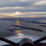
Now, we were going to be flying into the setting sun, and landing near civil twilight. I don't mind flying the end of the flight in the dark. If the weather is particularly wonderful with a full moon on snow, I don't mind flying at night in any sense. But full on night flying out our way is total black hole flying, so anytime the weather is less than stellar, I very much want to be down before dark. This winter, though, my desire to be down by dark is newly strengthened by the fact that my airplane is living in Naknek for the winter. And they don't have working runway lights there. And haven't had in, like, forever. The FSS briefer even remarked on that fact when we talked. Just about the time we passed Iliamna and the sun went down, I thought we'd be ending up in King Salmon, with the big, lighted runway.

But a few minutes later, we picked up a pretty hefty tailwind, and all of a sudden we were picking up the ten minutes of light we needed in the form of free airspeed. When we arrived, I had enough visibility to verify the wind direction on the sock, so we went ahead and turned final for 32, as that was the favored runway. But on short final, maybe even short, short, short final, I saw a guy in Carhartts on the runway, then he looked up, and dashed off. I offset to the side, made sure we missed him, then landed. He helped us put the plane away, and allowed as how he thought he had looked up, but apparently hadn't really noticed us, as he had to have looked right at us. Then he looked up again, and there we were. I had the light I needed to see him. But real runway lights would have been nice. I love the huge, tower-controlled runway in King Salmon, but the hangar I have access to is in Naknek, so for now that is where we are.
The meet ended, and we didn't go anywhere. I called to check the weather, it didn't sound like it should improve the next day, but the forecast said it would, so we arranged to meet at the plane the next day. When we got there, it wasn't really very good weather, and the plane was coated with ice. I tried some windshield de-icer we had in the car, but it really didn't make much progress very fast, so I called and arranged a hangar and pulled it in.
But as we watched the ice melt, we were also watching the weather. It really was not very good. It was almost okay, but not quite, and we were running short on daylight, and then it just didn't make sense to launch into uncertain conditions without being sure of the pass conditions when I would have failing light for getting back to Anchorage if the east end of the pass wasn't open. The wonderful FAA weather cams are almost worthless at times this winter, there are so many of them that are failing, including most of the Lake Clark Pass cams. So we left the plane in the hangar and headed off to watch a movie.
But the next day...more of the same. We were starting to feel like we were re-living some old episode of Gilligan's Island. We have friends in Anchorage. Well, we used to. Somewhere along here, as we came back yet again after an entire day of them thinking we were gone for good, they really might have been ready for us not to straggle back in. But Tuesday night was different. The forecast was for actual change, temperatures were dropping, the sky was clearing before our eyes, and we knew we would have a good day the following day.
Luckily I had a work commitment in the morning that prevented us from launching at first light. As it turned out, 747's were reporting moderate turbulence and low-level wind shear during the early part of the day. I'm not real fond of flying when those guys are getting beat up. No thanks. But by the time we launched at 2 pm, it was still windy but we had managed to miss all the crummy stuff.
It was beautifully clear up high, and we went up to 8,500 feet to stay above the bumps in the pass and avoid the clouds snaking through the pass down low. The cameras and the weather on the west side were a little uncertain, with low clouds showing throughout. She made a point to emphasize that VFR flight was not recommended. Which is true most of the time whenever I talk to them. So I decided to get up high where I had a good view and some options. The low clouds were in the pass all the way through, spilling out the east entrance. We stayed up above them and another plane entered the pass the same time we were flying over. He ducked below, said the visibility was okay, but partway down the pass he started picking up rime ice. When he got over Lake Clark itself, he climbed up through a big hole and off he went. We had a nice view of the mountains from up where we were, and had lots of emergency options even places to descend under the layer, as it had gaps along the north edge.
All along the way, we had views to the north of cloudless landscape, so we held a little north of our normal track, and called in to report our progress. Some of the flight service staff are pretty helpful, but some of them don't seem to have any real idea of the nature of options available if you, as a pilot, are willing to look for them. I report in all the time. Gives them some opportunity to connect real world operations to what they are seeing on their screens. And I do love being able to check on conditions by calling in and asking.
Now, we were going to be flying into the setting sun, and landing near civil twilight. I don't mind flying the end of the flight in the dark. If the weather is particularly wonderful with a full moon on snow, I don't mind flying at night in any sense. But full on night flying out our way is total black hole flying, so anytime the weather is less than stellar, I very much want to be down before dark. This winter, though, my desire to be down by dark is newly strengthened by the fact that my airplane is living in Naknek for the winter. And they don't have working runway lights there. And haven't had in, like, forever. The FSS briefer even remarked on that fact when we talked. Just about the time we passed Iliamna and the sun went down, I thought we'd be ending up in King Salmon, with the big, lighted runway.
But a few minutes later, we picked up a pretty hefty tailwind, and all of a sudden we were picking up the ten minutes of light we needed in the form of free airspeed. When we arrived, I had enough visibility to verify the wind direction on the sock, so we went ahead and turned final for 32, as that was the favored runway. But on short final, maybe even short, short, short final, I saw a guy in Carhartts on the runway, then he looked up, and dashed off. I offset to the side, made sure we missed him, then landed. He helped us put the plane away, and allowed as how he thought he had looked up, but apparently hadn't really noticed us, as he had to have looked right at us. Then he looked up again, and there we were. I had the light I needed to see him. But real runway lights would have been nice. I love the huge, tower-controlled runway in King Salmon, but the hangar I have access to is in Naknek, so for now that is where we are.
- Troy Hamon offline
- Posts: 913
- Joined: Tue Apr 06, 2010 8:27 am
- Location: King Salmon
- FindMeSpot URL: http://share.findmespot.com/shared/face ... 04iX0FXjV2
- Aircraft: Piper PA-22
Sat Dec 14, 2013 11:13 am
Re: Southwest Alaska Flying
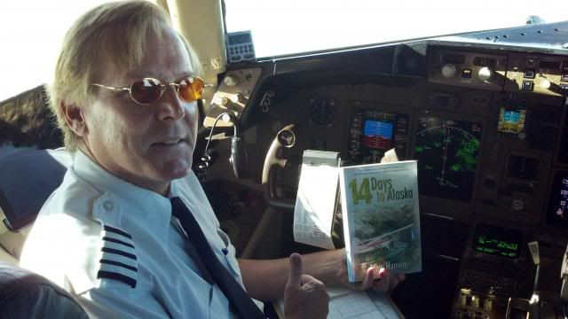
Around the time I took that photo of the sun low on the horizon...I took a photo of the cockpit...not a lot of activity going on in the other seats...

- Troy Hamon offline
- Posts: 913
- Joined: Tue Apr 06, 2010 8:27 am
- Location: King Salmon
- FindMeSpot URL: http://share.findmespot.com/shared/face ... 04iX0FXjV2
- Aircraft: Piper PA-22
Fri Dec 27, 2013 12:46 am
Re: Southwest Alaska Flying
Took a couple friends for a tour of the area. Most of the time we head north or west when I take people for a look-see. But the weather looked pretty nice out toward the mountains, so we headed up Big Creek, gawking at moose, then past the Contact Creek strip. The Kejuliks were visible from a long way away, and as we passed Contact Creek I could see the steam from the top of Mount Martin, which was in the sunshine. I didn't really want to climb that much since it is cold, and that makes for a temperature management challenge descending back down...but I had to do it. What a day.
Mount Martin in the distance is the cause of the steam...Pacific to the right, Bristol Bay to the left.

The Kejuliks, shrouded in clouds moving in from the Pacific (we were circling to gain altitude for our look at Mt Martin).

Mount Martin caldera.

Smelled like rotten eggs around there.

Katmai Caldera was out of the clouds as well. It is ice-free still, which suggests to me that it is likely getting some thermal input as well.

Valley of Ten Thousand Smokes.

VTTS surface is like artwork.

Mount Martin in the distance is the cause of the steam...Pacific to the right, Bristol Bay to the left.
The Kejuliks, shrouded in clouds moving in from the Pacific (we were circling to gain altitude for our look at Mt Martin).
Mount Martin caldera.
Smelled like rotten eggs around there.
Katmai Caldera was out of the clouds as well. It is ice-free still, which suggests to me that it is likely getting some thermal input as well.
Valley of Ten Thousand Smokes.
VTTS surface is like artwork.
- Troy Hamon offline
- Posts: 913
- Joined: Tue Apr 06, 2010 8:27 am
- Location: King Salmon
- FindMeSpot URL: http://share.findmespot.com/shared/face ... 04iX0FXjV2
- Aircraft: Piper PA-22
DISPLAY OPTIONS
Who is online
Users browsing this forum: No registered users and 0 guests
Latest Features
-
Live to Tell
A Minnesota pilot is surprised to learn that the sudden asymmetric drag of an out-of-rig ski can…Read More -
Creators
Working in some of the Yukon's most beautiful and remote environments, photographer Simon Blakesley captures aircraft in…Read More -
Aircraft Ownership and Maintenance
Upgrading to big tires can make a huge difference in backcountry performance, but with those gains come…Read More -
Tales from Yesteryear
In this tale from bush flying yesteryear, Don Cogger signs up to help Atlee Dodge Jr recovery…Read More


Latest Knowledge Base
-
Destinations
A regional guide with ideas for winter camping destinations in California, Nevada, New Mexico, and Arizona.Read More -
Aircraft
Finding an affordable aircraft that can handle the backcountry for $80K or less? A challenge for sure, but with the…Read More -
Aircraft
01.29.2018 - Zane - Updated tire diameter graphic to add 8.50x10 Guide to tires for use in the backcountry and off-airport landing…Read More -
Pilots
12.22.2013 - Initial article format Operating aircraft on skis and negotiating a snow-covered landscape is an entirely unique skillset and environment.…Read More


