
Long lost/uncharted/unknown Oregon airstrips...
Thu Mar 06, 2014 6:19 pm
Re: long lost/uncharted/unknown Oregon airstrips...
Airstrip? Succor Creek area, BLM Land.
- chosstronaut offline

- Posts: 543
- Joined: Thu Apr 05, 2012 5:07 pm
- Location: Corvallis
- FindMeSpot URL: http://share.findmespot.com/shared/face ... 9a7NU2UfGC
- Aircraft: Savannah
Tyler Adams, aka Chosstronaut, perished in a mid-air collision October 12, 2014. He was an enthusiastic and beloved contributor and he will be missed greatly.
Thu Mar 06, 2014 11:00 pm
- piperpainter offline
- Posts: 968
- Joined: Sat Nov 29, 2008 10:57 pm
- Location: Auburn, WA
- Aircraft: C-205
Was Backcountry Mooney M20C
Fri Mar 07, 2014 1:29 am
Re: long lost/uncharted/unknown Oregon airstrips...
Some time ago during a midlife crises, I was trying to figure out a way to make alot more money to buy serious plane toys and remembered a news story long ago about the Bagwan rajneesh who set up shop in Oregon, near the town of Antelope. This guy had it made. He had over 100 Rolls Royce's, his own airline, complete with turboprop aircraft and a 4000' runway. and a whole lot of gullible followers who adulated him to the hilt and payed all the bills by giving up all their net worth. I figured this cult leader gig payed pretty damned good with lots of tax advantages.
I was curious to see if the town of Rajneehpurum as they called it in those days still existed. After searching around on GE I fount it sitting on the NorthEast corner of the Jefferson and Wasco Counties. The runway is unmarked but looks to be in usable shape. Its now owned by Washington Family Ranch which operated sort of a retreat with many positive types of activities for kids as well as invites bookings for groups.
Could be, maybe a place for a not so backcountry flyin for families who don't appreciate backcountry facilities.
http://www.backcountrypilot.org/images/ ... ad2bd9.jpg
Tried for an hour to get this to view within post. Apparently being an expert at embedding videos does not transpose to embedding images.
As for the new career as a cult leader. The rein is short and usually ends up in a bad way.
- Sidewinder offline
- Posts: 340
- Joined: Mon Sep 30, 2013 5:07 pm
- Location: SouthWest Kanada eh?
Fri Mar 07, 2014 12:12 pm
Re: long lost/uncharted/unknown Oregon airstrips...
Nice! Usually when I see buildings I assume it is probably a private ranch strip, but ya never know? After all this GoogleEarth browsing I'd say there are probably 100+ privately owned personal strips that are not registered with the FAA strips in Oregon. The BLM overlay that svanarts posted here: http://www.backcountrypilot.org/community/forum/latest/blm-google-earth-overlay-14727 shows BLM land one township to the south of this strip, but I know its not entirely accurate because I noticed there is still some BLM land not in that overlay file that I've spotted. So who knows could maybe still be on BLM land. Either way any strip near water/fishing is a good strip by me!
- chosstronaut offline
- Posts: 543
- Joined: Thu Apr 05, 2012 5:07 pm
- Location: Corvallis
- FindMeSpot URL: http://share.findmespot.com/shared/face ... 9a7NU2UfGC
- Aircraft: Savannah
Tyler Adams, aka Chosstronaut, perished in a mid-air collision October 12, 2014. He was an enthusiastic and beloved contributor and he will be missed greatly.
Fri Mar 07, 2014 9:43 pm
Re: long lost/uncharted/unknown Oregon airstrips...
Sidewinder wrote:Some time ago during a midlife crises, I was trying to figure out a way to make alot more money to buy serious plane toys and remembered a news story long ago about the Bagwan rajneesh who set up shop in Oregon, near the town of Antelope. This guy had it made. He had over 100 Rolls Royce's, his own airline, complete with turboprop aircraft and a 4000' runway. and a whole lot of gullible followers who adulated him to the hilt and payed all the bills by giving up all their net worth. I figured this cult leader gig payed pretty damned good with lots of tax advantages.
I was curious to see if the town of Rajneehpurum as they called it in those days still existed. After searching around on GE I fount it sitting on the NorthEast corner of the Jefferson and Wasco Counties. The runway is unmarked but looks to be in usable shape. Its now owned by Washington Family Ranch which operated sort of a retreat with many positive types of activities for kids as well as invites bookings for groups.
Could be, maybe a place for a not so backcountry flyin for families who don't appreciate backcountry facilities.
Tried for an hour to get this to view within post. Apparently being an expert at embedding videos does not transpose to embedding images.
As for the new career as a cult leader. The rein is short and usually ends up in a bad way.

It's a giant christian camp now, I think its on the sectional as "Big Muddy". What a weird story that whole thing is!


Air Rajneesh
- chosstronaut offline
- Posts: 543
- Joined: Thu Apr 05, 2012 5:07 pm
- Location: Corvallis
- FindMeSpot URL: http://share.findmespot.com/shared/face ... 9a7NU2UfGC
- Aircraft: Savannah
Tyler Adams, aka Chosstronaut, perished in a mid-air collision October 12, 2014. He was an enthusiastic and beloved contributor and he will be missed greatly.
Fri Mar 07, 2014 9:57 pm
Re: long lost/uncharted/unknown Oregon airstrips...
Jordan Valley strip is on private ground and basically no longer exists

shawn coleman
2202T
tcraft f-22
2202T
tcraft f-22
Fri Mar 07, 2014 10:47 pm
Re: long lost/uncharted/unknown Oregon airstrips...
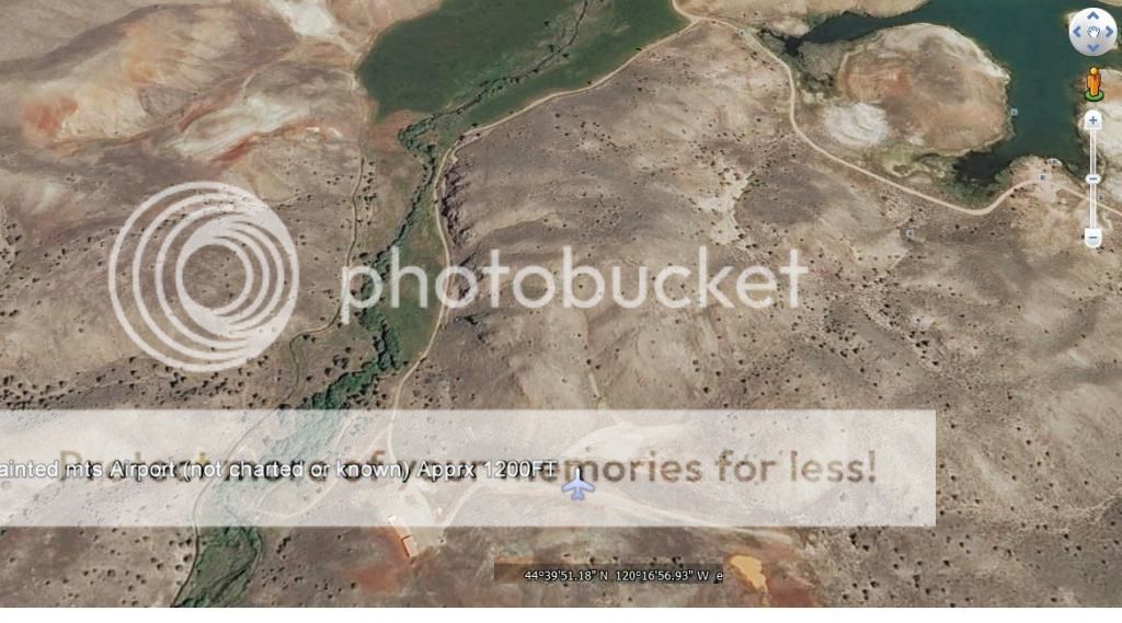
Big muddy is just north of that strip above near the painted hills!
- piperpainter offline
- Posts: 968
- Joined: Sat Nov 29, 2008 10:57 pm
- Location: Auburn, WA
- Aircraft: C-205
Was Backcountry Mooney M20C
Sat Mar 08, 2014 1:26 pm
Re: long lost/uncharted/unknown Oregon airstrips...
chosstronaut wrote:Here is a cool strip in the coast range I have flown over many times, its on a hill top just north of the town of Summit. its 1000' long and one way up hill to the east, an they appear to be doing some ag work out of it. Either way I've always wanted to land but don't know who to ask!

Land and ask if it's ok. Ha. It works most times. I figure I have the ok if I do a low approach and they wave.
Sat Mar 08, 2014 6:48 pm
Re: long lost/uncharted/unknown Oregon airstrips...
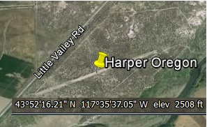
Harper Oregon #1

Harper Oregon #2
Lake of the Woods Ore ( West of K-Falls ) ATV riding area now.

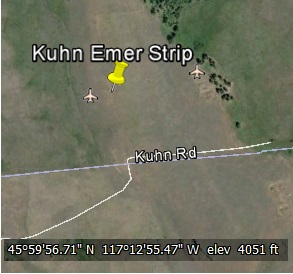
Kuhn Emergency Strip ( NE Oregon ) Always good to know of one.
Choss, Thanks for the shout out on page 1 of this post. It is frustrating to search for history when the people that had the info "back in the day" at the time didn't think anybody would ever want it or because it was "common knowledge" in those days. Example: We wait till our WW2 vets are 85 years old until we ask them about Pearl Harbor.
Guys, if you know something, pass it along. Somebody cares. I promise.
Harper Oregon #2
Lake of the Woods Ore ( West of K-Falls ) ATV riding area now.
Kuhn Emergency Strip ( NE Oregon ) Always good to know of one.
Choss, Thanks for the shout out on page 1 of this post. It is frustrating to search for history when the people that had the info "back in the day" at the time didn't think anybody would ever want it or because it was "common knowledge" in those days. Example: We wait till our WW2 vets are 85 years old until we ask them about Pearl Harbor.
Guys, if you know something, pass it along. Somebody cares. I promise.
- BladeRunner offline

- Posts: 133
- Joined: Wed Feb 05, 2014 12:46 pm
- Location: Willamette Valley, Oregon
Sat Mar 08, 2014 9:06 pm
Re: long lost/uncharted/unknown Oregon airstrips...
Neither of the Harper strips are useable but u guys can use mine og50 on cottonwood creek just east of Harper or
shawn coleman
2202T
tcraft f-22
2202T
tcraft f-22
Sat Mar 08, 2014 9:15 pm
Re: long lost/uncharted/unknown Oregon airstrips...
tcraft wrote:Neither of the Harper strips are useable but u guys can use mine og50 on cottonwood creek just east of Harper or
Do you mind if we do a few landings this Summer? The Eastside of the State is beautiful

CFII, MEI, CFISES, ATPME, IA/AP, RPPL, Ski&Amphib ops, RHC mechanic cert, RHC SC— 3000TT
Sat Mar 08, 2014 9:37 pm
Re: long lost/uncharted/unknown Oregon airstrips...
Sure feel free I'm usually around on weekends and Fridays on my family's ranch and 15 min from ontaro an 10 from vale
Shawn
Shawn
shawn coleman
2202T
tcraft f-22
2202T
tcraft f-22
Sat Mar 08, 2014 11:05 pm
Re: long lost/uncharted/unknown Oregon airstrips...
I know most of these are not usable  just adding for history's sake.
Camp Adair Ore. ( North of CVO ). Some say it never had a strip. Friend of mine said Cessna Bird-Dog was there when he was in the Ore NG. I dunno, lets not argue about Adair.

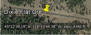
Dixie Flat ( West of LaGrande Ore )
Kinzua Danger strip. Bought quite a few 2x4's from Kinzua lumber. Good product.

Hey, lets hear from some other states out there! You guys know where they are. Post 'em in a new thread.
Camp Adair Ore. ( North of CVO ). Some say it never had a strip. Friend of mine said Cessna Bird-Dog was there when he was in the Ore NG. I dunno, lets not argue about Adair.
Dixie Flat ( West of LaGrande Ore )
Kinzua Danger strip. Bought quite a few 2x4's from Kinzua lumber. Good product.
Hey, lets hear from some other states out there! You guys know where they are. Post 'em in a new thread.
- BladeRunner offline
- Posts: 133
- Joined: Wed Feb 05, 2014 12:46 pm
- Location: Willamette Valley, Oregon
Sat Mar 08, 2014 11:17 pm
Re: long lost/uncharted/unknown Oregon airstrips...
A few more for you...just for history's sake.
Olallie Landing Field Ore. Wouldn't that have been great?

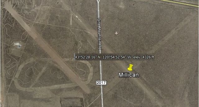
Good old Millican Oregon. Along with Brothers, a very sad fate indeed.
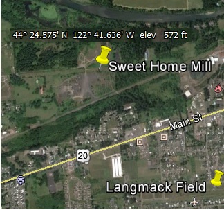
Langmack in Sweet Home Ore. It was always a challenge with the hill to the East.

Thanks for the memories.
Olallie Landing Field Ore. Wouldn't that have been great?
Good old Millican Oregon. Along with Brothers, a very sad fate indeed.
Langmack in Sweet Home Ore. It was always a challenge with the hill to the East.
Thanks for the memories.
- BladeRunner offline
- Posts: 133
- Joined: Wed Feb 05, 2014 12:46 pm
- Location: Willamette Valley, Oregon
Sun Mar 09, 2014 12:11 am
Re: long lost/uncharted/unknown Oregon airstrips...
While very interesting, this thread is kind of a bummer to see how many strips are no longer.
- Zzz offline


- Posts: 2854
- Joined: Fri Oct 08, 2004 11:09 pm
- Location: northern
- Aircraft: Swiveling desk chair
Half a century spent proving “it is better to be thought a fool than to open your mouth and remove all doubt.”
Sun Mar 09, 2014 12:56 am
Re: long lost/uncharted/unknown Oregon airstrips...
Z, I hear ya brother, I really hear ya.
And not to be confused with Langmack, there was a strip at the Mill, just south of the river in Sweet Home Ore.
In the hills South of Mollala Ore was the Old Dead Horse strip.

Above Scotts Mills Ore, on Crooked Finger rd is a Night Vision Goggle Helo Ops training area for the Salem ONG unit.
4 Wheelers keep it chewed up and its only about 450 ft so just don't.
( And you sling wing guys thought we didn't know about it )
)

And not to be confused with Langmack, there was a strip at the Mill, just south of the river in Sweet Home Ore.
In the hills South of Mollala Ore was the Old Dead Horse strip.
Above Scotts Mills Ore, on Crooked Finger rd is a Night Vision Goggle Helo Ops training area for the Salem ONG unit.
4 Wheelers keep it chewed up and its only about 450 ft so just don't.
( And you sling wing guys thought we didn't know about it
Last edited by BladeRunner on Sun Mar 09, 2014 2:38 am, edited 1 time in total.
- BladeRunner offline
- Posts: 133
- Joined: Wed Feb 05, 2014 12:46 pm
- Location: Willamette Valley, Oregon
Sun Mar 09, 2014 1:19 am
Re: long lost/uncharted/unknown Oregon airstrips...
tcraft wrote:Sure feel free I'm usually around on weekends and Fridays on my family's ranch and 15 min from ontaro an 10 from vale
Shawn
Hi Shawn,
"Roger that"! Real close to Lake Owyhee too. Lucky guy. Thank you for the post.
CFII, MEI, CFISES, ATPME, IA/AP, RPPL, Ski&Amphib ops, RHC mechanic cert, RHC SC— 3000TT
Sun Mar 09, 2014 9:03 am
Re: long lost/uncharted/unknown Oregon airstrips...
I am requesting that somebody look in an old publication for the Lat Long of the Hampton Ore ( US hwy 20 ) airport for me. PM me and I will find it and post. I could also use Riley Ore ( US hwy 20 )
In the mean time....
Oxbow Dam Ore

Flora Ore, Wluff Field

In the mean time....
Oxbow Dam Ore
Flora Ore, Wluff Field
- BladeRunner offline
- Posts: 133
- Joined: Wed Feb 05, 2014 12:46 pm
- Location: Willamette Valley, Oregon
Sun Mar 09, 2014 12:38 pm
Re: long lost/uncharted/unknown Oregon airstrips...
Some Kinzua history. The Kinzua Pine Mills Town site is in the canyon bottom on the right side of the Google earth tilted view. The view is looking NE. The airstrip is low in the middle and slopes uphill both directions. The slope is about 10% each way. landing can be interesting. Takeoff is usually from the NE to SW trying to be off the ground before the low point in the middle.
In the 1980's kinzua had an agreement with the Oregon Department of Forestry (ODF) to provide aerial detection of forest fires. They used a Cherokee 140 based out of Lexington. Often an ODF employee from Fossil would ride along as spotter. The pilot would pick them up at the kinzua airstrip and drop them off there again at the end of the flight.
Those guys had some pretty good stories about that airstrip. One involved a thunder storm during the flight that left quite a large puddle in the low point in the middle of the airstrip. On landing it splashed clear over the top of the old Cherokee.
For more Kinzua History and photos http://www.trainweb.org/highdesertrails/cks.html

tcj
Sun Mar 09, 2014 7:56 pm
Re: long lost/uncharted/unknown Oregon airstrips...
I accidently posted the same thing twice when I intended to edit. Oppps. 
So here I will post the old Anderson's Airport in Grand Ronde Ore. It was on the Seattle Sectional and is (was) located just West of the Casino. And SE of Wandering Sprit RV park on hwy18. On the South side is Andy Riggs rd. A good place ( was )to wait out the wx. when trying to get over the coast range pass to the beach and Lincoln City area. It would be great if was open and a shuttle bus would come get you so you could hit that great buffet dinner next door.
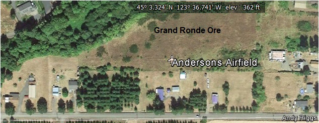
So here I will post the old Anderson's Airport in Grand Ronde Ore. It was on the Seattle Sectional and is (was) located just West of the Casino. And SE of Wandering Sprit RV park on hwy18. On the South side is Andy Riggs rd. A good place ( was )to wait out the wx. when trying to get over the coast range pass to the beach and Lincoln City area. It would be great if was open and a shuttle bus would come get you so you could hit that great buffet dinner next door.
Last edited by BladeRunner on Mon Mar 10, 2014 8:36 pm, edited 3 times in total.
- BladeRunner offline
- Posts: 133
- Joined: Wed Feb 05, 2014 12:46 pm
- Location: Willamette Valley, Oregon
DISPLAY OPTIONS
Who is online
Users browsing this forum: No registered users and 0 guests
Latest Features
-
Live to Tell
A Minnesota pilot is surprised to learn that the sudden asymmetric drag of an out-of-rig ski can…Read More -
Creators
Working in some of the Yukon's most beautiful and remote environments, photographer Simon Blakesley captures aircraft in…Read More -
Aircraft Ownership and Maintenance
Upgrading to big tires can make a huge difference in backcountry performance, but with those gains come…Read More -
Tales from Yesteryear
In this tale from bush flying yesteryear, Don Cogger signs up to help Atlee Dodge Jr recovery…Read More


Latest Knowledge Base
-
Destinations
A regional guide with ideas for winter camping destinations in California, Nevada, New Mexico, and Arizona.Read More -
Aircraft
Finding an affordable aircraft that can handle the backcountry for $80K or less? A challenge for sure, but with the…Read More -
Aircraft
01.29.2018 - Zane - Updated tire diameter graphic to add 8.50x10 Guide to tires for use in the backcountry and off-airport landing…Read More -
Pilots
12.22.2013 - Initial article format Operating aircraft on skis and negotiating a snow-covered landscape is an entirely unique skillset and environment.…Read More


