Backcountry Pilot • Long lost/uncharted/unknown Oregon airstrips...

Long lost/uncharted/unknown Oregon airstrips...

Discuss your knowledge of airports and off-airport strips. Help inform other pilots of status, warnings, noise abatement, and closure endangerment. See also: http://www.shortfield.com
167 postsPage 8 of 91 ... 5, 6, 7, 8, 9

Re: long lost/uncharted/unknown Oregon airstrips...

And how could I have forgotten good old French Glen Ore? ( or is that spelled Frenchglen? ) If you look carefully on G-earth, you can see what looks like a small foot bridge across the ditch ( perhaps it is a flood control dam?) The runway was East of the ditch and West of the marsh on USGS charts. It would be great if we could stop in for lunch at a place like this. I really like to support small town business.
Image

Image
Last edited by BladeRunner on Fri May 13, 2016 7:46 am, edited 1 time in total.
BladeRunner offline
User avatar
Posts: 133
Joined: Wed Feb 05, 2014 12:46 pm
Location: Willamette Valley, Oregon

Re: long lost/uncharted/unknown Oregon airstrips...

Logan Valley Ore. Looks like a very scenic place.
Image
BladeRunner offline
User avatar
Posts: 133
Joined: Wed Feb 05, 2014 12:46 pm
Location: Willamette Valley, Oregon

Re: long lost/uncharted/unknown Oregon airstrips...

Fossil Oregon. My old USGS map list this as a strip, but I'm thinking that it never was, and that the cartographer made a mistake. Now its a long drive way to several houses. You decide.
Image
BladeRunner offline
User avatar
Posts: 133
Joined: Wed Feb 05, 2014 12:46 pm
Location: Willamette Valley, Oregon

Re: long lost/uncharted/unknown Oregon airstrips...

Princeton Ore. SE of Burns. Near hwy 78. I don't know if it was ever open to the public. Just adding to the list.
Image
BladeRunner offline
User avatar
Posts: 133
Joined: Wed Feb 05, 2014 12:46 pm
Location: Willamette Valley, Oregon

Re: long lost/uncharted/unknown Oregon airstrips...

Crowley Guard Station Ore.
The G-Earth pics of this part of Oregon are not very good. And as usual, the little airplane icon is not in the correct location.
Image

So I went here to get a better view:
http://www.ormap.net/flexviewer/index.html
and this is what I found. It looks like there is a strip on the South side of the road, but it could be a fence line. Ormap.net only gives Lat/Long in Decimal Degrees so I did the conversion. In G-Earth you can switch formats by going to "tools/options/show Lat-Long/ and click on the third one down. This will give you the standard format that aviation GPS's use. Remember that Aviation GPS's, FAA A/FD, and sectional charts do not use "seconds". [-X They use decimal minutes. And so should we all here at BCP. ( Just my opinion :mrgreen: )

Image

I was not convinced that this was an old strip. I pulled up the USGS chart, and found this one:
Image

I would be interesting to know the history on this place.
BladeRunner offline
User avatar
Posts: 133
Joined: Wed Feb 05, 2014 12:46 pm
Location: Willamette Valley, Oregon

Re: long lost/uncharted/unknown Oregon airstrips...

Crowley Landing ( Ranch ) Ore. { read that as pvt land ! ]
G-Earth has a poor pic so go here:
http://www.ormap.net/flexviewer/index.html
You will need to convert from decimal degrees to degree, decimal minutes.

Image

Not to be confused with Crowley Guard Station. Not even close.
Last edited by BladeRunner on Fri May 13, 2016 8:16 am, edited 1 time in total.
BladeRunner offline
User avatar
Posts: 133
Joined: Wed Feb 05, 2014 12:46 pm
Location: Willamette Valley, Oregon

Re: long lost/uncharted/unknown Oregon airstrips...

chosstronaut wrote:Warm Springs BLM Airstrip at Warm Springs Reservoir SE of Juntura.

Image

Now whats interesting is here is the imaging from 2012, it appears that they built a road, that double as an airstrip?

Image


I've confirmed that this was an airstrip based on some older maps, and I believe it was paved to continue its use as such.
chosstronaut offline
User avatar
Posts: 543
Joined: Thu Apr 05, 2012 5:07 pm
Location: Corvallis
FindMeSpot URL: http://share.findmespot.com/shared/face ... 9a7NU2UfGC
Aircraft: Savannah
Tyler Adams, aka Chosstronaut, perished in a mid-air collision October 12, 2014. He was an enthusiastic and beloved contributor and he will be missed greatly.

Re: long lost/uncharted/unknown Oregon airstrips...

I found the old topo map site I used to use: http://mapper.acme.com/ so now I can find some more strips.

Here is what I'll call "Upper Table Airstrip" it is on BLM land so its legal to land, it sits above the South Fork of the Crooked River, to the South East of Paulina.

Image

Image
chosstronaut offline
User avatar
Posts: 543
Joined: Thu Apr 05, 2012 5:07 pm
Location: Corvallis
FindMeSpot URL: http://share.findmespot.com/shared/face ... 9a7NU2UfGC
Aircraft: Savannah
Tyler Adams, aka Chosstronaut, perished in a mid-air collision October 12, 2014. He was an enthusiastic and beloved contributor and he will be missed greatly.

Re: long lost/uncharted/unknown Oregon airstrips...

chosstronaut wrote:"Bates Airstrip" right next to Bates State Park near the junction of Highway 26 & Highway 7. Possibly an old USFS strip?

Image


It is a strip...

Image
chosstronaut offline
User avatar
Posts: 543
Joined: Thu Apr 05, 2012 5:07 pm
Location: Corvallis
FindMeSpot URL: http://share.findmespot.com/shared/face ... 9a7NU2UfGC
Aircraft: Savannah
Tyler Adams, aka Chosstronaut, perished in a mid-air collision October 12, 2014. He was an enthusiastic and beloved contributor and he will be missed greatly.

Re: long lost/uncharted/unknown Oregon airstrips...

Old BLM Airstrip on the John Day

Image

Image
chosstronaut offline
User avatar
Posts: 543
Joined: Thu Apr 05, 2012 5:07 pm
Location: Corvallis
FindMeSpot URL: http://share.findmespot.com/shared/face ... 9a7NU2UfGC
Aircraft: Savannah
Tyler Adams, aka Chosstronaut, perished in a mid-air collision October 12, 2014. He was an enthusiastic and beloved contributor and he will be missed greatly.

Re: long lost/uncharted/unknown Oregon airstrips...

East Road Gulch BLM Airstrip

Image

Image
chosstronaut offline
User avatar
Posts: 543
Joined: Thu Apr 05, 2012 5:07 pm
Location: Corvallis
FindMeSpot URL: http://share.findmespot.com/shared/face ... 9a7NU2UfGC
Aircraft: Savannah
Tyler Adams, aka Chosstronaut, perished in a mid-air collision October 12, 2014. He was an enthusiastic and beloved contributor and he will be missed greatly.

Re: long lost/uncharted/unknown Oregon airstrips...

Willow Spring BLM Airstrip

Image

Image
chosstronaut offline
User avatar
Posts: 543
Joined: Thu Apr 05, 2012 5:07 pm
Location: Corvallis
FindMeSpot URL: http://share.findmespot.com/shared/face ... 9a7NU2UfGC
Aircraft: Savannah
Tyler Adams, aka Chosstronaut, perished in a mid-air collision October 12, 2014. He was an enthusiastic and beloved contributor and he will be missed greatly.

Re: long lost/uncharted/unknown Oregon airstrips...

BladeRunner wrote:
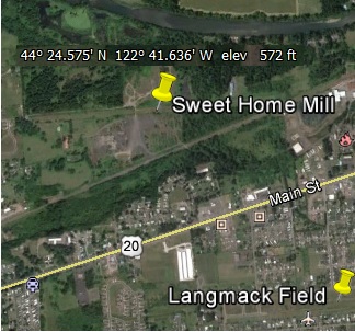
And not to be confused with Langmack, there was a strip at the Mill, just south of the river in Sweet Home Ore.
Image


That strip was built by the Tomco Lumbar Co. and is now owned by some christian group. There is still a cool old group of hangers there, and the east 200' seem to be somewhat maintained, not sure if there are any planes in the hangers, and there are X's on both ends of the strip... I've drug my tires on it before, it still seems to work #-o
chosstronaut offline
User avatar
Posts: 543
Joined: Thu Apr 05, 2012 5:07 pm
Location: Corvallis
FindMeSpot URL: http://share.findmespot.com/shared/face ... 9a7NU2UfGC
Aircraft: Savannah
Tyler Adams, aka Chosstronaut, perished in a mid-air collision October 12, 2014. He was an enthusiastic and beloved contributor and he will be missed greatly.

Re: long lost/uncharted/unknown Oregon airstrips...

In Response to the Summit Meadow thread, I thought that I would bump this one. Tyler dug up a lot of great information in this thread.
Scolopax offline
Supporter
User avatar
Posts: 1696
Joined: Tue Sep 27, 2005 5:02 pm
Location: Nottingham
FindMeSpot URL: http://share.findmespot.com/shared/face ... 4aYqSexnZC

Re: long lost/uncharted/unknown Oregon airstrips...

Dahl Pine
On Oregon Hwy 26 in the Warm Spring Reservation...but if your crossing the Cascades via Timothy Lakes/South of Mt. Hood and the weather is closing in,....any port in a storm guys. I have no info on this place or condition.

Image

Image

We all miss ya T
BladeRunner offline
User avatar
Posts: 133
Joined: Wed Feb 05, 2014 12:46 pm
Location: Willamette Valley, Oregon

Re: Long lost/uncharted Oregon airstrips!

[quote="chosstronaut"]Now I know this strip has been discussed on this site before. Cold Springs USFS Airstrip.

[img]http://www.backcountrypilot.org/images/originalphotos/3354/3635/e749539f02fd0e4ae09a2945.jpg[/img][/quote]

I've been told this strip was put in to spray gypsy moths, with a fleet of Stearman sprayers in the 60's? From the air, its huge, could easily support DC3's, but as was stated earlier, erosion has left big rocks scattered everywhere. Currently Bushwheel use only..
wingnut185 offline
User avatar
Posts: 60
Joined: Tue Dec 30, 2008 10:58 am
Location: left coast

Re: long lost/uncharted/unknown Oregon airstrips...

Dahl Pine is on the Rez. You get caught and the Indians will most likely take your plane. Image
OregonMaule offline
User avatar
Posts: 6977
Joined: Fri Sep 01, 2006 9:44 pm
Location: Orygun
My SPOT page

"They who can give up essential liberty to obtain a little temporary safety, deserve neither liberty nor safety". Ben Franklin
http://en.wikiquote.org/wiki/Benjamin_Franklin

Re: long lost/uncharted/unknown Oregon airstrips...

[quote="chosstronaut"]This strip is located on NF land near the headwaters of the South Fork of the John Day.

[img]http://www.backcountrypilot.org/images/originalphotos/3354/3635/78682ba25f6a09f87cdb1d5d.jpg[/img][/quote]

I believe Ellingson Lumber Company built this in the 70's? I was told they flew an Aztec in and out. Remnants of a wood framed hanger remain. Plenty comfortable on 8.50's, though it can be very muddy, vehicles often leave deep ruts.
wingnut185 offline
User avatar
Posts: 60
Joined: Tue Dec 30, 2008 10:58 am
Location: left coast

Re: long lost/uncharted/unknown Oregon airstrips...

Readers,
Remember, Tyler and I started this whole thread just to document old strips for historic reasons. Most, if not all, are overgrown, tore up, or otherwise unusable. Please don't mistake any of this for some kind of "trip report" ( which we all need to see more of here on BCP, please ).

Our sport will disappear as fast as the brush grows due to lack of funds and interest in keeping strips open.
Have some spare time? Volunteer for a work party. Know a Old Timer that talks some about a old strip? Post it here.

This is all just to document history. I love old maps. Not sure why I do, but I just does :D


158 posts here, 3311 views,...not bad.


Remember the Alamo?... I say "Remember Tunnel Meadows Ca" !!
BladeRunner offline
User avatar
Posts: 133
Joined: Wed Feb 05, 2014 12:46 pm
Location: Willamette Valley, Oregon

Re: long lost/uncharted/unknown Oregon airstrips...

Hawks Valley Ore.

Image

Again, not a trip report, just archiving for the future. :lol: :mrgreen:

T, I miss your help buddy. You were really good at finding old strips.
BladeRunner offline
User avatar
Posts: 133
Joined: Wed Feb 05, 2014 12:46 pm
Location: Willamette Valley, Oregon

DISPLAY OPTIONS

PreviousNext
167 postsPage 8 of 91 ... 5, 6, 7, 8, 9

Who is online

Users browsing this forum: No registered users and 0 guests

Latest Features

Latest Knowledge Base