Southwest Alaska Flying
Mon Jul 29, 2013 4:12 am
Re: Southwest Alaska Flying
Fabulous pictures and great narrative descriptions of the scenes. Thanks for sharing. Every time I see a collection of images like this I kick myself for not flying to Alaska while I lived in the Seattle area. Yes, Seattle is still a very long way from even the southeast corner of the state, but it's a heck of a lot closer than Virginia. Keep the pictures (and maybe videos) coming so folks like me can live vicariously through your exploits.

Mon Jul 29, 2013 1:47 pm
Re: Southwest Alaska Flying
Troy
Sure enjoyed your pictures of Wood Tikchik. I spent three summers guiding there in the early 90's at Wood River Lodge. I got to roam all over the lower lakes with a jet boat and tried to explore every nook and cranny. I have to go back and see if the fish are still in all the secret spots. That corner that you have in your picture of the Wind is may favorite spot. Grayling all over and the view behind is spectacular. Grant creek is pretty good for rainbows too. I think there is a lot more pressure there than when I was there, not sure if I should go back or just remember it as it was. Lots of great memories there!
Joe Prax
Valdez
Tue Jul 30, 2013 11:20 pm
Re: Southwest Alaska Flying
Troy,
Embarrassingly enough, I was Spot stalking you today. I stole that term from my 18-year old daughter who described staring at my Spot page during the trip up from the lower 48. Anyways, I thought you said you were hoping for the weather to hold out until Tuesday. Looks like you didn't get out like you had planned. I hope your neck is better.
Brett
Wed Jul 31, 2013 9:02 am
Re: Southwest Alaska Flying
Hey Brett, I do that when somebody has something interesting planned as well, funny. The neck feels fine, but the weather window looked like it was closing down on the Port Heiden end. I've spent a lot of time in Aniakchak, and sitting in that volcano with a tent for weeks is educational. Sitting there with an airplane to worry about is another matter entirely, so I was looking for weather so good that the only issue would be fog. We had that but it was supposed to be transitioning to ceilings below 1,000 feet and winds 20 kts or higher at Port Heiden. As the winds rise in Port Heiden, it gets wild in the volcano, so I got a little less excited about running down there last night.
In point of fact, the weather down there this morning is great, so it likely would have been fine...but there will be a next time. Just might have to wait a bit. Got to get a plan for another trip soon though, or I'll get an itchy throttle finger.
In point of fact, the weather down there this morning is great, so it likely would have been fine...but there will be a next time. Just might have to wait a bit. Got to get a plan for another trip soon though, or I'll get an itchy throttle finger.
- Troy Hamon offline
- Posts: 913
- Joined: Tue Apr 06, 2010 8:27 am
- Location: King Salmon
- FindMeSpot URL: http://share.findmespot.com/shared/face ... 04iX0FXjV2
- Aircraft: Piper PA-22
Wed Jul 31, 2013 9:11 am
Re: Southwest Alaska Flying
Hmmm...great weather for Port Heiden might have been an overstatement. Looks like it might have worked, but clouds over toward the caldera look pretty low with breaks and the wind is already picking up in Port Heiden. My son had friends over and it definitely wasn't good enough for me to suggest he curtail his teenager party, so there we are.
- Troy Hamon offline
- Posts: 913
- Joined: Tue Apr 06, 2010 8:27 am
- Location: King Salmon
- FindMeSpot URL: http://share.findmespot.com/shared/face ... 04iX0FXjV2
- Aircraft: Piper PA-22
Wed Aug 28, 2013 2:21 am
Re: Southwest Alaska Flying
Had a flight a couple weeks back that was an above average workout. I was headed to town for work, and my son was along because he was going to visit some of his friends and get a little summer break from village life. But on Friday evening, the first time we could have had a go at it, the wind was picking up something fierce. Around King Salmon, that can be a little uncomfortable. But around Iliamna and Port Alsworth, it usually suggests winds in Lake Clark Pass that are staggeringly abusive to a little plane. Having staggered through some of that abuse in the past, I wasn't really looking forward to it this time, so I told Cedric we probably should wait unless he wanted to get beat up pretty bad.
"No, that's okay Dad. I want to get to Anchorage to visit Colton, but we don't have to go tonight."
"That's probably good, as the forecast is for winds in Turnagain arm to hit 50 and above, which makes for terrible winds on the west side of Cook Inlet as well. If we leave right now, we'll get beat up bad in the pass, then beat up bad along Cook Inlet. But the wind is supposed to diminish tomorrow in the afternoon, so we could go tomorrow and get there in the evening."
That sounded like a plan, anyway, so we slept on it. In the morning, we got up and the wind was still howling, as forecast. But as mid-day arrived and the forecast was updated, the time of the diminishing winds in the forecast was pushed back...and back...
"Uh oh, Cedric. It looks like the winds tonight are pretty bad still after all. And they are likely going to stay that way all the way until tomorrow morning now. It isn't so windy that it is unsafe, but it would certainly be uncomfortable. The problem is that tomorrow is the last day before I have to be at work, and although the winds will be dropping, there may be some areas of low ceilings tomorrow, so the down side is that I may need to give up on the flight and fly commercial, in which case you will miss the trip."
"That's okay Dad. I mean, I want to go and all, but I definitely would rather not go when the winds are going to make me sick."
I called to visit with a friend about the weather...
"Why don't you call and check with the commercial airline to see whether they have seats available? That way, if they have only one seat anytime tomorrow, you know you better grab it. But if they have lots of seats, you could wait and see what the weather offers you when you get up in the morning."
Wow, that is some good thinking, right there.
So I called the airline and they had lots of seats on every flight the next day. Perfect.
Sunday dawned foggy and cloudy, but by noon it had lifted enough to be obviously improving. The weathercams for Lake Clark Pass were not as helpful as they could be, because the most important one of all was down for maintenance, so there wasn't a whole lot to go on there other than the weatherman's forecast.
But it really did look like we should be able to get to town, so I decided to go ahead and launch. Cedric and I crawled in the Island Girl and fired her up, then took off into 700 scattered, overcast 1200. I didn't bother to climb above the 700 layer because at Igiugig they were reporting a 500 foot ceiling, so I figured I may as well not kid myself about going above anything until I got to Iliamna, where they were reporting a ceiling of 5000 feet.

As we flew along, hanging below a low ceiling but with silky smooth air and decent visibility, we found ourselves peeking over the Iliamna terminal moraine with a ceiling at 500 msl, which put it pretty low...something like 300 feet...but then as the ground dropped away we were noticing that the clouds seemed low too. I have long preferred visibility to ceiling, but I like having at least a little air beneath me. We crossed the Kvichak River at 350 feet, and we still had good visibility, but it didn't look entirely convincing ahead...as in it didn't look like we'd be able to continue to see...and Igiugig was reporting 300 feet and 3 miles. Hmm...

As we neared the northwest corner of Lake Iliamna, the visibility had deteriorated along the direction we wanted to travel to the point where I was looking at visibility near 2 miles.

I'm not very fond of that, unless I have reason to believe that it will get better soon, but I could see the lake shore, and that would at least give me a good visual reference as I tried to evaluate the flight path.
"Cedric, I don't like the visibility here."
"I don't like it either, Dad!"
"When we get up to the lake shore, we are going to look to see whether we still have the visibility we need looking along the lake shore. If not, we will just turn and go land at Igiugig to wait for the weather to improve."
"That sounds good."
As we neared the lake shore, it was impossible to be sure what the visibility was over the lake, a totally featureless mass of steely-gray blue fading into the featureless white cloud that seeped down to meet it. But we had a really good view down the lake toward Igiugig, back to our right. To our left...well...
"Okay, I can't see very well to the left here, it looks like I can only see about a mile up the lake shore. I don't mind flying a mile or two in those conditions, but if it doesn't improve quickly, we'll turn around and head for Igiugig."
"Okay, Dad."
In the end, it was totally academic. As we turned to the left, I noted the place along the lake shore where the visibility faded into oblivion. Usually when you fly in poor visibility, that spot moves away from you as you fly toward it. But in this case, it didn't move, and we were clearly approaching a wall of no visibility.
"I don't like the looks of that at all...we're going to Igiugig!"
I turned inland, over the trees, to make a 180 degree turn and head back down the lake shore. It helps to maintain a really solid visual reference, and the lake fading up into clouds fading down was not that reference, so I turned the other way. Now, flying toward Igiugig, I couldn't help but wonder how officially reported 300 and 3 weather would compare to what we had just flown through. I dialed up the Igiugig weather frequency...
"Eye-Gwee-Gig Airport...automated weather observation..." The computerized guy just can't, despite all his electrons, pronounce ih-gee-ah-gig, it makes me chuckle very time.
He claimed it was 500 and 5, which sounded pretty luxurious, but as we approached Igiugig along shore it was clear he wasn't fibbing.
"Cedric, the weather down here is pretty good, and since I already looked at the Kokhanok weathercams and they were good too, instead of stopping at Igiugig we'll just head along the south shore of Iliamna and see if we can get across Bruin Bay."
"That sounds good."
As we passed Igiugig, it was clear that the weather really was getting better along the way, and soon we had a lovely view of the Kvichak River, draining the largest lake in Alaska, and Igiugig nestled along the banks.

Visibility was still occasionally impeded now by showers, but for the most part as we headed east along the south shore of the lake it was pretty outstanding.

Before we had even arrived at Big Mountain, we could see all the way across the lake.
"Cedric, look at that, can you see that?"
"What?"
"Over there, across the lake, what do you see?"
"Is it...land?"
"Yes! The other lakeshore! Too bad I'm allergic to water, or we could just fly across the lake!"
By the time we passed Kokhanok, it had become so good that it was hard to imagine what the other end of the lake had looked like.

I kept looking across the lake, and thinking about it, but I had Bruin Bay on the mind now, so I headed down toward the pass. I'm not very fond of Bruin Bay. I try to scope out new country during really nice weather before I make a decision about what sort of bad weather I will tolerate. Class G weather minimums are so low that you can legally fly yourself into a corner you can't get out of if you don't plan ahead and manage your exposure. I do that by limiting my tolerance for anything less than 3 mile visibility to short stretches of familiar, flat terrain. On the charts, Bruin Bay looks good because it is the lowest pass that gets you across the mountains toward Anchorage. But when I flew it at 3,000 feet a couple years ago for the first time, it looked like if you were pinned down below a cloud layer it would stick you out over water, cliffed out from having any terrain for an emergency landing.
And I'm allergic to water.
As we neared the pass over to Bruin Bay, there was a tongue of cloud sneaking over from the Cook Inlet side, but it had a nice ceiling underneath it, so I ducked underneath it for a look. But as we crossed over the pass, looking generally down, I couldn't see the water ahead of me, and I was going to be descending...and looking...and descending...
"Cedric, I don't like it, we're turning around."
We zipped right back out of there back into the fabulous weather we had just left, and it was decision time.
"Well, we may as well just go to Port Alsworth. We made it through all the ugly stuff, so let's go there, land, fuel up, and see what reports we get on Lake Clark Pass."
On the way to Iliamna, we climbed up to get some terrain clearance, then kept climbing so we could cross over Flat Island and Knutson Bay with glide distance to land the entire way. Because...you guessed it...I'm allergic to water.
From there, I was looking at terrain I hadn't ever really flown before, so we headed up toward Tazimina Lake. But before we got there we crossed a canyon that was pretty impressive...


Peered at the sectional...and laughed. The creek is named Canyon Creek. Should have seen that one coming.
As we continued on, reveling in the smooth air, the high ceiling, and the gentle winds, we passed between upper and lower Tazimina Lakes, and headed into the pass that would drop us down right above Port Alsworth.

From there, we headed for midfield on the Wilder/Natwick runway to evaluate the wind sock. The breeze was favoring 5R, so we entered right downwind and announced our position. A reply came immediately.
"Port Alsworth traffic, Skylane northeast, straight in for 23L."
Hmm...
"Tri-Pacer on downwind for 5 right, I can do a 360 for spacing if you need me to."
"No, we haven't made it to the camel humps yet, we're about 10 out."
Okay, never mind...so we landed and taxied to the fuel pump. Our meandering track was preserved nicely by our spot page.

I filled the right tank and went to pay. When I came back, the guy that usually is helping out at the fuel area and around the shop was shaking his head.
"The news is not so good. That 206 went all the way through the pass then ran into weather behind Big River Lakes. They turned around and came all the way back through the pass."
"That doesn't sound so good..."
"No..."
Hmm...
"Dad, what's going on?"
"Well, I really don't know yet. That plane just went all the way through Lake Clark Pass and found some bad weather on the other side and had to turn around and come all the way back here. So we better have a look before we take off. What a mess it would be now if I can't make it to work on time. But that's my own fault, so we'll just see what it looks like and if there is a way to get there. But first I'm going to look at the other webcams."
I pulled out my phone (how did we manage without these things, anyway?) and pulled up the FAA weathercams. This time I looked at Merrill Pass, then at Ptarmigan Pass. Merrill looked pretty good, and when I went to the Alaska Volcano Observatory webcam for the Spurr hut that is at the eastern entrance to Merrill, that looked fairly okay as well. Hmm...
"Cedric, we're going to fill the other tank, pay for the gas, then probably head up to look at Merrill Pass."
While I was fueling, one of the folks that had deplaned from the 206 came over.
"Were you guys hoping to get through Lake Clark Pass?"
"Well, that was our intention, but it sounded like it was a bit of a problem?"
"Yeah, we made it all the way through there and then, after we exited the Narrows, there was a wall of clouds there."
"Wow, that makes it sort of tough."
"Yeah, it looked like it went down to maybe below 500 feet. The pilot looked at it, then said it was below his minimums, and turned around. There's a lot of moisture pushing through from Cook Inlet. It is even getting worse over here. Were going to wait here for a Casa that is coming in a few minutes, and launch out of here on that."
My wheels were starting to turn. The clouds went down to 500 feet? Over Big River? Certainly that is not good weather. But it would have been a lot more informative if he had dropped down low enough to look underneath, the visibility is the real critical item in that situation...
"Well, we're thinking we might head up north and look at Merrill Pass, or even Ptarmigan if the western entrance to Merrill is not looking good."
"Oh, up north, well we just came down through that, and it isn't very good up there either, at least by Sparrevohn. We started way out west, tried to fly in to Anchorage yesterday and just got hammered, had to sit down and spend a night in one of the villages. Then today on the way here from up north of here, we occasionally had to descend to 1000 feet just to maintain ceiling."
Okay, at that point I decided I really needed to talk to the pilot. While I really appreciated the passenger sharing all this, I wasn't sure the numbers he was passing on were accurate. I certainly knew that before I started training, I couldn't have been relied on to give accurate condition reports based on what I was seeing as a passenger. He might have been more reliable than me, so I was going to give him the benefit of the doubt, but thought it would help to verify with the pilot.
But it was not to be. The pilot came past while in conversation with another gentleman, making a comment along the lines of, "and the good part is, I'm still alive!"...then hopped in a pickup that had the bags and gear from the plane loaded into it, and headed down the runway to meet the plane they were going to ride out on.
Hmm...
I've never had a strong desire to be one of those accident statistics where people fly off into the terrible weather they are warned again, and are then found the following day by a search party looking for them when the weather is nice. And not necessarily found living, either. But the report I had heard sounded like flyable weather. Not ideal. But depending what the visibility underneath was, perhaps not even bad.
While I was standing there, my friend Dan pulled up.
"Hey, you going somewhere?"
I filled him in on the situation.
"You want to come over to my house and look things over on a decent monitor instead of your little phone?"
"You know, that actually sounds like a really good idea. Give me a minute to get my plane parked out of the way."
We went over to Dan's house and took a little time to examine all the weather information we could find. Merrill was still bad up top, but the tendrils of clouds around the AVO cam near the east entrance were thickening, and looking like something serious. If I am going to fly all the way through a pass and have to fly back, I'd rather fly through Lake Clark Pass. I started looking around at the AVO cams more closely.
One of the Redoubt cameras caught my eye. It was located on an oil platform, and had been turned toward Redoubt after initially being pointed toward Spurr. It had a good field of view that included the outflow of Big River where it came out of Lake Clark Pass.
"Look at that!"
"What do you see?"
"Right here, see that? Right where the coast is, a definite ceiling, easily identified from however many miles away this camera is. So there is a good cloud deck, just like they said, but it really does look like it has a nice bottom that is at least 500 feet up, and there is visibility beneath!"
"Sure enough!"
"So, Dad, what does that mean, anyway?" Cedric was looking over our shoulders.
"Well, it means you and I are going to fly through Lake Clark Pass, because right now it looks like it should work fine."
We went back to the plane, and Cedric sat down in the grass while I looked things over.

"I know we've only been gone a short while, but when I let the airplane out of my sight I want to make sure nobody has decided to try to kill me while I've been gone, so I'm going to do a complete preflight again. And I am also going to do it because I've never taken off when somebody else has just told me it isn't safe. I want to make sure I'm careful here. But the report we got sounded like conditions we can fly in safely, and the cameras suggested the same thing. But I want to make sure I am proceeding methodically and not rushing anything."
"Yeah, so weird, it's like he doesn't know what he's doing to turn around when it is like that, huh?"
"Whoah there...not so at all!" I could see this would need to be discussed. How to go about it?
"One of the most important things a pilot has to do is set his minimums and abide by them. You change your minimums when you know for a fact you can operate safely with different minimums. Not when your minimums are inconvenient. I have no idea why his minimums are what they are. But I can tell you that when I got my license, I wouldn't fly through if I thought we were going to come out with a 500 foot ceiling. That would have been a no-go for me. But since then, I have become very familiar with the pass, and with our airplane. I know for a fact that I can turn around with a 500 foot ceiling anywhere in the pass, including the narrows, and do it completely safely. I didn't necessarily know that, and I might not have been as ready to slow down to help make maneuvers like that when I had flown less. I have no idea what that pilot's experience is, but don't ever think it is a bad thing for a pilot to abide by his minimums."
"But if he really flew his airplane a lot he'd get better at it?"
"It isn't even about whether he is good at flying. He might be up here from the lower 48 and used to flying instruments. He might just not want to fly low level. He could have thousands of hours, I really don't know. But it is really important that you start to understand that minimums are a life saving tool every pilot needs to keep in his pocket. My minimums in Lake Clark Pass are a bit different though. I need 300 feet, though I prefer a lot more, and 3 miles visibility. If I am flying out of the pass on the Cook Inlet side, and get out of the narrows, 2 miles is okay, but if it gets down to less than that I would turn around and come back as well. But if you are interested in being a pilot, you need to learn to make informed judgments about the weather and you need to do it without other people hassling you into flying when you can't do it safely. And as part of that, you need to make sure you don't pressure somebody else into feeling like they are being wimpy for not flying when they don't feel safe about it. And we might get through there and find that the weather is below my minimums. Or we may get through there and find that the situation has changed completely and the weather is great."
"Okay, so I have to learn how to set minimums too."
"Eventually, yes."
Somewhere during this long conversation the preflight had been finished, the airplane started, and we had launched off toward the pass. We went past the apparently extinguished (again) Currant Creek fire.

The lake was beautifully calm before us as we headed uplake.

Occasionally in the pass I would see a restriction of visibility ahead and think maybe it was going to be a problem...

But it would quickly become apparent that it was just a little spot of rain we would be flying through.

And then the visibility would be great on the other side.

Fireweed season was in full swing along the pass.

Somewhere in there I caught one side of a conversation between two airplanes.
"I completely understand what he was saying, but based on what I heard, I wouldn't have made the same call, but I certainly can relate to where he was coming from."
A short time later, the same voice announced, "Lake Clark Pass traffic, Navajo westbound at Summit Lake."
"Lake Clark Pass traffic, Tri-Pacer eastbound abeam the glacier fork. What does the east end look like?"
"It's not bad, there is a ceiling that is 600 feet or better, and visibility is good."
"Very good, thank you."
We turned into the Narrows and had a view of the lower ceiling ahead, but it really did look good underneath, so we descended to stay below and headed out of the pass.

As we turned out of the narrows below the clouds, the visibility ahead was clearly much better than it had been when we were looking at the cameras.

As we finished turning the corner, we could see Moose Ridge more than 10 miles in the distance.

From that point on, the rest of the flight was pretty straightforward. Good flying in good weather.

Plenty of practice thinking. Plenty of practice turning around. What would I do different?
Well, for starters, I don't really know that there was any point turning north along the Iliamna Lakeshore. I should have just turned toward Igiugig when I saw how foul it looked off to my left. Secondly, I should have abandoned Bruin Bay as an alternative without sticking my nose in there. I maintained good visibility and clearance, but the way that cloud was snaking through the pass, that couldn't have really suggested anything good under there. But I was pleased that in both cases I didn't hesitate to turn around. I always appreciate being with a pilot that is willing to turn around. I want to be one of those guys. On this trip, I was one of those guys twice.
"No, that's okay Dad. I want to get to Anchorage to visit Colton, but we don't have to go tonight."
"That's probably good, as the forecast is for winds in Turnagain arm to hit 50 and above, which makes for terrible winds on the west side of Cook Inlet as well. If we leave right now, we'll get beat up bad in the pass, then beat up bad along Cook Inlet. But the wind is supposed to diminish tomorrow in the afternoon, so we could go tomorrow and get there in the evening."
That sounded like a plan, anyway, so we slept on it. In the morning, we got up and the wind was still howling, as forecast. But as mid-day arrived and the forecast was updated, the time of the diminishing winds in the forecast was pushed back...and back...
"Uh oh, Cedric. It looks like the winds tonight are pretty bad still after all. And they are likely going to stay that way all the way until tomorrow morning now. It isn't so windy that it is unsafe, but it would certainly be uncomfortable. The problem is that tomorrow is the last day before I have to be at work, and although the winds will be dropping, there may be some areas of low ceilings tomorrow, so the down side is that I may need to give up on the flight and fly commercial, in which case you will miss the trip."
"That's okay Dad. I mean, I want to go and all, but I definitely would rather not go when the winds are going to make me sick."
I called to visit with a friend about the weather...
"Why don't you call and check with the commercial airline to see whether they have seats available? That way, if they have only one seat anytime tomorrow, you know you better grab it. But if they have lots of seats, you could wait and see what the weather offers you when you get up in the morning."
Wow, that is some good thinking, right there.
So I called the airline and they had lots of seats on every flight the next day. Perfect.
Sunday dawned foggy and cloudy, but by noon it had lifted enough to be obviously improving. The weathercams for Lake Clark Pass were not as helpful as they could be, because the most important one of all was down for maintenance, so there wasn't a whole lot to go on there other than the weatherman's forecast.
But it really did look like we should be able to get to town, so I decided to go ahead and launch. Cedric and I crawled in the Island Girl and fired her up, then took off into 700 scattered, overcast 1200. I didn't bother to climb above the 700 layer because at Igiugig they were reporting a 500 foot ceiling, so I figured I may as well not kid myself about going above anything until I got to Iliamna, where they were reporting a ceiling of 5000 feet.
As we flew along, hanging below a low ceiling but with silky smooth air and decent visibility, we found ourselves peeking over the Iliamna terminal moraine with a ceiling at 500 msl, which put it pretty low...something like 300 feet...but then as the ground dropped away we were noticing that the clouds seemed low too. I have long preferred visibility to ceiling, but I like having at least a little air beneath me. We crossed the Kvichak River at 350 feet, and we still had good visibility, but it didn't look entirely convincing ahead...as in it didn't look like we'd be able to continue to see...and Igiugig was reporting 300 feet and 3 miles. Hmm...
As we neared the northwest corner of Lake Iliamna, the visibility had deteriorated along the direction we wanted to travel to the point where I was looking at visibility near 2 miles.
I'm not very fond of that, unless I have reason to believe that it will get better soon, but I could see the lake shore, and that would at least give me a good visual reference as I tried to evaluate the flight path.
"Cedric, I don't like the visibility here."
"I don't like it either, Dad!"
"When we get up to the lake shore, we are going to look to see whether we still have the visibility we need looking along the lake shore. If not, we will just turn and go land at Igiugig to wait for the weather to improve."
"That sounds good."
As we neared the lake shore, it was impossible to be sure what the visibility was over the lake, a totally featureless mass of steely-gray blue fading into the featureless white cloud that seeped down to meet it. But we had a really good view down the lake toward Igiugig, back to our right. To our left...well...
"Okay, I can't see very well to the left here, it looks like I can only see about a mile up the lake shore. I don't mind flying a mile or two in those conditions, but if it doesn't improve quickly, we'll turn around and head for Igiugig."
"Okay, Dad."
In the end, it was totally academic. As we turned to the left, I noted the place along the lake shore where the visibility faded into oblivion. Usually when you fly in poor visibility, that spot moves away from you as you fly toward it. But in this case, it didn't move, and we were clearly approaching a wall of no visibility.
"I don't like the looks of that at all...we're going to Igiugig!"
I turned inland, over the trees, to make a 180 degree turn and head back down the lake shore. It helps to maintain a really solid visual reference, and the lake fading up into clouds fading down was not that reference, so I turned the other way. Now, flying toward Igiugig, I couldn't help but wonder how officially reported 300 and 3 weather would compare to what we had just flown through. I dialed up the Igiugig weather frequency...
"Eye-Gwee-Gig Airport...automated weather observation..." The computerized guy just can't, despite all his electrons, pronounce ih-gee-ah-gig, it makes me chuckle very time.
He claimed it was 500 and 5, which sounded pretty luxurious, but as we approached Igiugig along shore it was clear he wasn't fibbing.
"Cedric, the weather down here is pretty good, and since I already looked at the Kokhanok weathercams and they were good too, instead of stopping at Igiugig we'll just head along the south shore of Iliamna and see if we can get across Bruin Bay."
"That sounds good."
As we passed Igiugig, it was clear that the weather really was getting better along the way, and soon we had a lovely view of the Kvichak River, draining the largest lake in Alaska, and Igiugig nestled along the banks.
Visibility was still occasionally impeded now by showers, but for the most part as we headed east along the south shore of the lake it was pretty outstanding.
Before we had even arrived at Big Mountain, we could see all the way across the lake.
"Cedric, look at that, can you see that?"
"What?"
"Over there, across the lake, what do you see?"
"Is it...land?"
"Yes! The other lakeshore! Too bad I'm allergic to water, or we could just fly across the lake!"
By the time we passed Kokhanok, it had become so good that it was hard to imagine what the other end of the lake had looked like.
I kept looking across the lake, and thinking about it, but I had Bruin Bay on the mind now, so I headed down toward the pass. I'm not very fond of Bruin Bay. I try to scope out new country during really nice weather before I make a decision about what sort of bad weather I will tolerate. Class G weather minimums are so low that you can legally fly yourself into a corner you can't get out of if you don't plan ahead and manage your exposure. I do that by limiting my tolerance for anything less than 3 mile visibility to short stretches of familiar, flat terrain. On the charts, Bruin Bay looks good because it is the lowest pass that gets you across the mountains toward Anchorage. But when I flew it at 3,000 feet a couple years ago for the first time, it looked like if you were pinned down below a cloud layer it would stick you out over water, cliffed out from having any terrain for an emergency landing.
And I'm allergic to water.
As we neared the pass over to Bruin Bay, there was a tongue of cloud sneaking over from the Cook Inlet side, but it had a nice ceiling underneath it, so I ducked underneath it for a look. But as we crossed over the pass, looking generally down, I couldn't see the water ahead of me, and I was going to be descending...and looking...and descending...
"Cedric, I don't like it, we're turning around."
We zipped right back out of there back into the fabulous weather we had just left, and it was decision time.
"Well, we may as well just go to Port Alsworth. We made it through all the ugly stuff, so let's go there, land, fuel up, and see what reports we get on Lake Clark Pass."
On the way to Iliamna, we climbed up to get some terrain clearance, then kept climbing so we could cross over Flat Island and Knutson Bay with glide distance to land the entire way. Because...you guessed it...I'm allergic to water.
From there, I was looking at terrain I hadn't ever really flown before, so we headed up toward Tazimina Lake. But before we got there we crossed a canyon that was pretty impressive...
Peered at the sectional...and laughed. The creek is named Canyon Creek. Should have seen that one coming.
As we continued on, reveling in the smooth air, the high ceiling, and the gentle winds, we passed between upper and lower Tazimina Lakes, and headed into the pass that would drop us down right above Port Alsworth.
From there, we headed for midfield on the Wilder/Natwick runway to evaluate the wind sock. The breeze was favoring 5R, so we entered right downwind and announced our position. A reply came immediately.
"Port Alsworth traffic, Skylane northeast, straight in for 23L."
Hmm...
"Tri-Pacer on downwind for 5 right, I can do a 360 for spacing if you need me to."
"No, we haven't made it to the camel humps yet, we're about 10 out."
Okay, never mind...so we landed and taxied to the fuel pump. Our meandering track was preserved nicely by our spot page.
I filled the right tank and went to pay. When I came back, the guy that usually is helping out at the fuel area and around the shop was shaking his head.
"The news is not so good. That 206 went all the way through the pass then ran into weather behind Big River Lakes. They turned around and came all the way back through the pass."
"That doesn't sound so good..."
"No..."
Hmm...
"Dad, what's going on?"
"Well, I really don't know yet. That plane just went all the way through Lake Clark Pass and found some bad weather on the other side and had to turn around and come all the way back here. So we better have a look before we take off. What a mess it would be now if I can't make it to work on time. But that's my own fault, so we'll just see what it looks like and if there is a way to get there. But first I'm going to look at the other webcams."
I pulled out my phone (how did we manage without these things, anyway?) and pulled up the FAA weathercams. This time I looked at Merrill Pass, then at Ptarmigan Pass. Merrill looked pretty good, and when I went to the Alaska Volcano Observatory webcam for the Spurr hut that is at the eastern entrance to Merrill, that looked fairly okay as well. Hmm...
"Cedric, we're going to fill the other tank, pay for the gas, then probably head up to look at Merrill Pass."
While I was fueling, one of the folks that had deplaned from the 206 came over.
"Were you guys hoping to get through Lake Clark Pass?"
"Well, that was our intention, but it sounded like it was a bit of a problem?"
"Yeah, we made it all the way through there and then, after we exited the Narrows, there was a wall of clouds there."
"Wow, that makes it sort of tough."
"Yeah, it looked like it went down to maybe below 500 feet. The pilot looked at it, then said it was below his minimums, and turned around. There's a lot of moisture pushing through from Cook Inlet. It is even getting worse over here. Were going to wait here for a Casa that is coming in a few minutes, and launch out of here on that."
My wheels were starting to turn. The clouds went down to 500 feet? Over Big River? Certainly that is not good weather. But it would have been a lot more informative if he had dropped down low enough to look underneath, the visibility is the real critical item in that situation...
"Well, we're thinking we might head up north and look at Merrill Pass, or even Ptarmigan if the western entrance to Merrill is not looking good."
"Oh, up north, well we just came down through that, and it isn't very good up there either, at least by Sparrevohn. We started way out west, tried to fly in to Anchorage yesterday and just got hammered, had to sit down and spend a night in one of the villages. Then today on the way here from up north of here, we occasionally had to descend to 1000 feet just to maintain ceiling."
Okay, at that point I decided I really needed to talk to the pilot. While I really appreciated the passenger sharing all this, I wasn't sure the numbers he was passing on were accurate. I certainly knew that before I started training, I couldn't have been relied on to give accurate condition reports based on what I was seeing as a passenger. He might have been more reliable than me, so I was going to give him the benefit of the doubt, but thought it would help to verify with the pilot.
But it was not to be. The pilot came past while in conversation with another gentleman, making a comment along the lines of, "and the good part is, I'm still alive!"...then hopped in a pickup that had the bags and gear from the plane loaded into it, and headed down the runway to meet the plane they were going to ride out on.
Hmm...
I've never had a strong desire to be one of those accident statistics where people fly off into the terrible weather they are warned again, and are then found the following day by a search party looking for them when the weather is nice. And not necessarily found living, either. But the report I had heard sounded like flyable weather. Not ideal. But depending what the visibility underneath was, perhaps not even bad.
While I was standing there, my friend Dan pulled up.
"Hey, you going somewhere?"
I filled him in on the situation.
"You want to come over to my house and look things over on a decent monitor instead of your little phone?"
"You know, that actually sounds like a really good idea. Give me a minute to get my plane parked out of the way."
We went over to Dan's house and took a little time to examine all the weather information we could find. Merrill was still bad up top, but the tendrils of clouds around the AVO cam near the east entrance were thickening, and looking like something serious. If I am going to fly all the way through a pass and have to fly back, I'd rather fly through Lake Clark Pass. I started looking around at the AVO cams more closely.
One of the Redoubt cameras caught my eye. It was located on an oil platform, and had been turned toward Redoubt after initially being pointed toward Spurr. It had a good field of view that included the outflow of Big River where it came out of Lake Clark Pass.
"Look at that!"
"What do you see?"
"Right here, see that? Right where the coast is, a definite ceiling, easily identified from however many miles away this camera is. So there is a good cloud deck, just like they said, but it really does look like it has a nice bottom that is at least 500 feet up, and there is visibility beneath!"
"Sure enough!"
"So, Dad, what does that mean, anyway?" Cedric was looking over our shoulders.
"Well, it means you and I are going to fly through Lake Clark Pass, because right now it looks like it should work fine."
We went back to the plane, and Cedric sat down in the grass while I looked things over.
"I know we've only been gone a short while, but when I let the airplane out of my sight I want to make sure nobody has decided to try to kill me while I've been gone, so I'm going to do a complete preflight again. And I am also going to do it because I've never taken off when somebody else has just told me it isn't safe. I want to make sure I'm careful here. But the report we got sounded like conditions we can fly in safely, and the cameras suggested the same thing. But I want to make sure I am proceeding methodically and not rushing anything."
"Yeah, so weird, it's like he doesn't know what he's doing to turn around when it is like that, huh?"
"Whoah there...not so at all!" I could see this would need to be discussed. How to go about it?
"One of the most important things a pilot has to do is set his minimums and abide by them. You change your minimums when you know for a fact you can operate safely with different minimums. Not when your minimums are inconvenient. I have no idea why his minimums are what they are. But I can tell you that when I got my license, I wouldn't fly through if I thought we were going to come out with a 500 foot ceiling. That would have been a no-go for me. But since then, I have become very familiar with the pass, and with our airplane. I know for a fact that I can turn around with a 500 foot ceiling anywhere in the pass, including the narrows, and do it completely safely. I didn't necessarily know that, and I might not have been as ready to slow down to help make maneuvers like that when I had flown less. I have no idea what that pilot's experience is, but don't ever think it is a bad thing for a pilot to abide by his minimums."
"But if he really flew his airplane a lot he'd get better at it?"
"It isn't even about whether he is good at flying. He might be up here from the lower 48 and used to flying instruments. He might just not want to fly low level. He could have thousands of hours, I really don't know. But it is really important that you start to understand that minimums are a life saving tool every pilot needs to keep in his pocket. My minimums in Lake Clark Pass are a bit different though. I need 300 feet, though I prefer a lot more, and 3 miles visibility. If I am flying out of the pass on the Cook Inlet side, and get out of the narrows, 2 miles is okay, but if it gets down to less than that I would turn around and come back as well. But if you are interested in being a pilot, you need to learn to make informed judgments about the weather and you need to do it without other people hassling you into flying when you can't do it safely. And as part of that, you need to make sure you don't pressure somebody else into feeling like they are being wimpy for not flying when they don't feel safe about it. And we might get through there and find that the weather is below my minimums. Or we may get through there and find that the situation has changed completely and the weather is great."
"Okay, so I have to learn how to set minimums too."
"Eventually, yes."
Somewhere during this long conversation the preflight had been finished, the airplane started, and we had launched off toward the pass. We went past the apparently extinguished (again) Currant Creek fire.
The lake was beautifully calm before us as we headed uplake.
Occasionally in the pass I would see a restriction of visibility ahead and think maybe it was going to be a problem...
But it would quickly become apparent that it was just a little spot of rain we would be flying through.
And then the visibility would be great on the other side.
Fireweed season was in full swing along the pass.
Somewhere in there I caught one side of a conversation between two airplanes.
"I completely understand what he was saying, but based on what I heard, I wouldn't have made the same call, but I certainly can relate to where he was coming from."
A short time later, the same voice announced, "Lake Clark Pass traffic, Navajo westbound at Summit Lake."
"Lake Clark Pass traffic, Tri-Pacer eastbound abeam the glacier fork. What does the east end look like?"
"It's not bad, there is a ceiling that is 600 feet or better, and visibility is good."
"Very good, thank you."
We turned into the Narrows and had a view of the lower ceiling ahead, but it really did look good underneath, so we descended to stay below and headed out of the pass.
As we turned out of the narrows below the clouds, the visibility ahead was clearly much better than it had been when we were looking at the cameras.
As we finished turning the corner, we could see Moose Ridge more than 10 miles in the distance.
From that point on, the rest of the flight was pretty straightforward. Good flying in good weather.
Plenty of practice thinking. Plenty of practice turning around. What would I do different?
Well, for starters, I don't really know that there was any point turning north along the Iliamna Lakeshore. I should have just turned toward Igiugig when I saw how foul it looked off to my left. Secondly, I should have abandoned Bruin Bay as an alternative without sticking my nose in there. I maintained good visibility and clearance, but the way that cloud was snaking through the pass, that couldn't have really suggested anything good under there. But I was pleased that in both cases I didn't hesitate to turn around. I always appreciate being with a pilot that is willing to turn around. I want to be one of those guys. On this trip, I was one of those guys twice.
- Troy Hamon offline
- Posts: 913
- Joined: Tue Apr 06, 2010 8:27 am
- Location: King Salmon
- FindMeSpot URL: http://share.findmespot.com/shared/face ... 04iX0FXjV2
- Aircraft: Piper PA-22
Sat Sep 14, 2013 2:18 am
Re: Southwest Alaska Flying
This has been quite the period for Alaska flying. The start of hunting season every year is an aviation horror show, and this year has been no different, perhaps a little worse. There are a few possible reasons why this time of year is so chock-full of bent metal. The one that people often bring up in discussion is the infrequent flyer that does very little flying, then takes off for a hunt in an aircraft that is fully capable of going places the pilot is not tuned up enough to go. Certainly that is a possibility. But it does also neglect the simple mathematics of the season. Even if everybody is practicing throughout the year, this is the event they are practicing for. So while there are pilots flying all the time, they are all flying at this time...
So there might be a question of proficiency. And there are certainly more airplanes flying now. And people have been planting airplanes into lakes, meadows, streambeds, and who knows what else in the past couple weeks. Some of those people have been walking away. But not all of them.
Scouting for animals from the air can be fun and educational. But it can also be fatal. We have had what appear to be moose stall fatalities already this month. And guess what I decided to go do today? Actually, I've been looking for my opportunity for a few days...to fly around and look for moose. I had work assignments that precluded any hunting opportunities up until today, so today was a bit hectic. Worked for most of the day, ran off to get a hunting license (hadn't actually been hunting yet this year) and a registration permit along with my son (but no, we aren't going to shoot two moose...), then we put some gas in the Island Girl and headed out to look for Bullwinkle.
Now there are a bunch of reasons why people kill themselves looking at moose. Most of them can boil down to everyone in the plane being transformed by the sight of a moose into a passenger, with nobody diligently taking care to ensure that the airplane is fully piloted. In an attempt to facilitate viewing, instead of flying, the airplane can be put into an attitude that leads to a stall, unfortunately a low-altitude, uncoordinated stall. Not a good story.
I have a few rules about looking at animals. One is that I don't make a hard circle over an animal when I see it. If I do circle, it is after an approach where the circle is planned. But anytime I see an animal beneath the plane, I fly past, then turn and come back if I am going to try to help somebody else get a look at it.
But here is where the animal spotting and the hunting don't add up to me...
I don't circle back to look at any animals during hunting season, regardless of who in the airplane wants to see it. Flying loops over an animal during hunting season is like erecting a huge sign in the willows..."MOOSE HERE! COME AND GET HIM!!!"
Of all times to be circumspect about such things, it is when there are other people around hunting.
So Cedric and I were heading out to look for moose. But really, we were just looking for some reassurance that there were moose somewhere out there. I haven't been seeing moose around. The pilots I visit with have not been seeing them either. I know they are out there. I saw a lot in some places last winter. I have seen a few this fall, just not many. But there is something reassuring about seeing a moose from the air before you commit hundreds of dollars of boat or airplane gas to go chasing them. At least you know there is a moose in the general vicinity, so it shouldn't be a total waste of time.
But the reality is that I haven't ever actually shot a moose that I saw from the air. Last year we never even made it up the river to the point where my daughter and I saw the bulls we flew over. But it was certainly encouraging to have seen them.
Cedric removed the tie-downs while I fueled the plane and did the pre-flight inspection. Everything looked fine other than the cloud of black flies swirling around my head. Which was a very good sign...it was nearly calm.
I had arranged flight following with my wife..."Do you want me to file with Kenai Radio?"
"No, I can follow you from here."
"We're just going to fly Big Creek. It really shouldn't take us long, the farthest I can see us going is to Contact Creek to land, but I'm not sure I want to do that, depends on how things go."
Cedric and I were loaded in the plane, and we had the spot tracker on to allow her to keep track of our progress. Whenever I first turn it on, I send an OK message to alert her that we are on and ready to go, it sends a text message to her phone. There were all sorts of aircraft in the air, a float plane crossing the end of the runway, then we were cleared to depart and turn the opposite direction. Right as we lifted off, another plane was cleared to land behind us, then as we crossed the end of the long main runway after turning south, an airplane was cleared to take off right toward us. Lots of planes, lots of fun. We kept an eye on the Caravan that was taking off as it was going to be turning south as well, so we wanted to make sure we weren't in the way.
But we soon were up Big Creek far enough that it was obvious we wouldn't be getting in anybody's way unless they were flying the creek like we were. Cedric started looking hard out the window, and I started looking hard out the window, then forward, then at the gauges, then back out the window...it is hard work scanning and looking for animals. You really have to plan for the workload. I had decided I wanted to go ahead and try to scan on the way upriver, then I was going to put the creek out Cedric's window for the trip downriver and let him have the best view.
"Look for swans."
"Okay. Why?"
"Well, sometimes if you find two swans together in the brush it will turn out they are moose antlers..."
"Oh! Okay!"
But we did in fact find swans, but not any that would turn into moose antlers. Pretty soon we passed the end of the boatable areas of the creek, and knew that we didn't have any way to get any further.
"Well, Cedric, here's the deal. We haven't found any moose. We can fly back down the river and go home, which will make this a pretty short flight, and that's find. Or we can fly over to Contact Creek and land, or down to the outlet of Becharof Lake to land if you want to get out and stretch our legs."
"Mmmm...okay. That sounds good."
"Which one sounds good?"
"I dunno, they sound fine."
"Okay, well, if it doesn't matter to you we could just head back downstream."
"I mean, landing somewhere sounds good."
"Okay...well it looks like we are probably closest to Contact Creek, so let's go there."
I had landed at Contact Creek before, but not for some time. In fact, the Island Girl had never been there. And my daughter is the only family member that had been there with me. It is just a little strip in the tundra created by landing aircraft. And it is just about, almost exactly in fact...1200 feet long. That is long enough for me to operate out of just fine. Barely. The surface is a little on the bumpy side for my little tires, and a little soft, and slopes up a bit one way. It isn't bad, but it is challenging enough that I figure it is not a full load strip for me in a PA-22 probably ever. Perhaps if I had VG's it would be different. The landing is not the challenge, it is pretty short for departure...
"Cedric, I really do want to make sure I am on top of my game if I'm going to take you into this strip, so on the way there, we're going to climb up and fly some stalls. Have you heard about stalls before?"
"Yeah."
"What have you heard?"
"They are, like, dangerous."
"Well, that's somewhat true. They are dangerous down low, and they are dangerous if they are flown uncoordinated. But every pilot has to learn to fly them, to recognize them, and to recover from them. That's how you learn to land well and safely while still making use of short strips, and we're going to a short strip. So we're going to fly a couple stalls now. Are you ready?"
"Okay..."
"This first one is a departure stall. We are plenty high now to make sure we can recover in time to make sure we have well over 1500 feet below us even after recovery. The important thing is that we maintain perfect coordination throughout this maneuver, so watch this ball, we're going to keep it right in the center as we climb with full power so steep that we can't make the airplane keep climbing."
We pulled the nose up slowly into an improbably high pitch angle. Then a little more. The airspeed bled off to 70, then 60, then was nearing 50...there was a small buffet, then I pushed the nose forward a tiny bit and right as the stall was getting ready to break the plane dipped forward enough to maintain flight attitude, while losing some altitude.
"Okay, the next one is an approach to landing stall. You ready? We're going to pull the power almost all the way off, slow down, all the flaps, then I'm going to pull up again until it breaks again..."
But this time it wouldn't break. With the yoke fully back, we were descending in a mush, the stall buffet playing with the tailfeathers, but refusing to progress to a full stall.
"Okay, looks like we can't get it to stall on a descent to landing stall, we'll have to put something heavy in the back next time so I can show that to you. How was that?"
"It was okay. Sort of steep. I was realizing it was like totally steep, then I was also realizing it was exactly what you described, but I wasn't expecting it to be so steep."
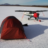
At this point, I was ready to go see what the strip looked like, and we were almost there. As I peered ahead, I could make out a pair of tents just off the end of the runway. Hmm...
"I don't know how I feel about that, Cedric. I hate to bug them and make a mess of their camping trip."
Cedric was silent, and we flew over the strip, looking around. I didn't see anybody around, which surprised me. I figured they would be fishing in the creek, but nobody obvious. I had noticed as we approached the area that a slight tailwind was blowing through the notch in the hills that we had come through. That put us with a slight headwind in the downhill direction...
One of the pilots that I know had told me he always tries to land uphill on this strip and take off downhill unless the wind is pretty convincingly strong. I looked at it, though about it, and decided that I wanted to try an approach from the downhill side first, and if it looked like it was going to be too fast I would go the other way. But a downhill landing would have me buzzing in right over the tents, so I decided to try the other way first.
On downwind, Cedric made a comment that didn't make any sense to me...I gave him a blank look...
He tried to explain, but I had to cut him off.
"Not now, Cedric. I'm sorry, but you'll have to tell me later, right now I need to fully concentrate on landing."
I lined up on final, looking great, stable as a rock, coming in right on target. My groundspeed on medium final was 76, about 8 mph higher than it should have been, but not bad, and I was steadily slowing.
As I dropped in lower, it was obvious that the landing was no problem to do safely.
"Okay Cedric, we're going to go ahead and land it."
We touched down in soft field fashion, and the chatter was definitely more than I had been into with the Island Girl. She squawked a bit. As we taxied up to the end of the strip, one of the tents was open, and a lady was looking directly at us through binoculars.
Hey, wait a minute...I recognize that person!
It was one of the NPS rangers I know from work!
"Hey Cedric, these are people I work with! How'd you like that landing, a little bumpy?"
"Yeah, bumpy, is right!"
The strip is mostly rocks about half the size of a fist. Not bad, but a little more than normal for sure. We taxied in, hopped out, and greeted the rangers.

They invited us to stay for some cocoa, and who can say no to that? So our landing turned into a gabfest, and we chatted for a while. This corner of our country is so little visited, yet shockingly beautiful. And the night was so nice that we were not feeling pressed for time. Perhaps we should have felt some time pressure, as Gwenyth's birthday party was going to be happening soon, but it is really hard to feel like running off when you are greeted with such hospitality.

I looked up as we were drinking our cocoa, and there was a rainbow right behind the camp.

I had to take advantage of that...
"Hey, can you take a photo of Cedric and me?"

It turned out that one of them was a pilot, which I hadn't realized. So I had a good long talk with him about the plane, and they were both asking me about the book and the new plane. But eventually, we figured we really should put in an appearance at a party held in our own house for our own family member...so we loaded back in and blasted off.
This time, Cedric was the designated spotter. I put the stream out his window and we flew all the way down Big Creek from the absolute top. Most of that is totally inaccessible to us. But we were looking anyway.

Cedric was holding his mic to keep the vent air from making it squawk, and looking for moose.

And looking.
And looking.
But lo and behold, we found one. Now it wasn't where it is convenient to hunt. And since I haven't really started packing, and there's a lot of work to get done, I don't expect to get on the water before 2 pm. Probably more like 5 pm. So honestly, we aren't even going to have a chance to call it until two days after seeing it. And they can cover a lot of country. But I feel just a little more optimistic about our hunt...
Couldn't have had a better flight.
So there might be a question of proficiency. And there are certainly more airplanes flying now. And people have been planting airplanes into lakes, meadows, streambeds, and who knows what else in the past couple weeks. Some of those people have been walking away. But not all of them.
Scouting for animals from the air can be fun and educational. But it can also be fatal. We have had what appear to be moose stall fatalities already this month. And guess what I decided to go do today? Actually, I've been looking for my opportunity for a few days...to fly around and look for moose. I had work assignments that precluded any hunting opportunities up until today, so today was a bit hectic. Worked for most of the day, ran off to get a hunting license (hadn't actually been hunting yet this year) and a registration permit along with my son (but no, we aren't going to shoot two moose...), then we put some gas in the Island Girl and headed out to look for Bullwinkle.
Now there are a bunch of reasons why people kill themselves looking at moose. Most of them can boil down to everyone in the plane being transformed by the sight of a moose into a passenger, with nobody diligently taking care to ensure that the airplane is fully piloted. In an attempt to facilitate viewing, instead of flying, the airplane can be put into an attitude that leads to a stall, unfortunately a low-altitude, uncoordinated stall. Not a good story.
I have a few rules about looking at animals. One is that I don't make a hard circle over an animal when I see it. If I do circle, it is after an approach where the circle is planned. But anytime I see an animal beneath the plane, I fly past, then turn and come back if I am going to try to help somebody else get a look at it.
But here is where the animal spotting and the hunting don't add up to me...
I don't circle back to look at any animals during hunting season, regardless of who in the airplane wants to see it. Flying loops over an animal during hunting season is like erecting a huge sign in the willows..."MOOSE HERE! COME AND GET HIM!!!"
Of all times to be circumspect about such things, it is when there are other people around hunting.
So Cedric and I were heading out to look for moose. But really, we were just looking for some reassurance that there were moose somewhere out there. I haven't been seeing moose around. The pilots I visit with have not been seeing them either. I know they are out there. I saw a lot in some places last winter. I have seen a few this fall, just not many. But there is something reassuring about seeing a moose from the air before you commit hundreds of dollars of boat or airplane gas to go chasing them. At least you know there is a moose in the general vicinity, so it shouldn't be a total waste of time.
But the reality is that I haven't ever actually shot a moose that I saw from the air. Last year we never even made it up the river to the point where my daughter and I saw the bulls we flew over. But it was certainly encouraging to have seen them.
Cedric removed the tie-downs while I fueled the plane and did the pre-flight inspection. Everything looked fine other than the cloud of black flies swirling around my head. Which was a very good sign...it was nearly calm.
I had arranged flight following with my wife..."Do you want me to file with Kenai Radio?"
"No, I can follow you from here."
"We're just going to fly Big Creek. It really shouldn't take us long, the farthest I can see us going is to Contact Creek to land, but I'm not sure I want to do that, depends on how things go."
Cedric and I were loaded in the plane, and we had the spot tracker on to allow her to keep track of our progress. Whenever I first turn it on, I send an OK message to alert her that we are on and ready to go, it sends a text message to her phone. There were all sorts of aircraft in the air, a float plane crossing the end of the runway, then we were cleared to depart and turn the opposite direction. Right as we lifted off, another plane was cleared to land behind us, then as we crossed the end of the long main runway after turning south, an airplane was cleared to take off right toward us. Lots of planes, lots of fun. We kept an eye on the Caravan that was taking off as it was going to be turning south as well, so we wanted to make sure we weren't in the way.
But we soon were up Big Creek far enough that it was obvious we wouldn't be getting in anybody's way unless they were flying the creek like we were. Cedric started looking hard out the window, and I started looking hard out the window, then forward, then at the gauges, then back out the window...it is hard work scanning and looking for animals. You really have to plan for the workload. I had decided I wanted to go ahead and try to scan on the way upriver, then I was going to put the creek out Cedric's window for the trip downriver and let him have the best view.
"Look for swans."
"Okay. Why?"
"Well, sometimes if you find two swans together in the brush it will turn out they are moose antlers..."
"Oh! Okay!"
But we did in fact find swans, but not any that would turn into moose antlers. Pretty soon we passed the end of the boatable areas of the creek, and knew that we didn't have any way to get any further.
"Well, Cedric, here's the deal. We haven't found any moose. We can fly back down the river and go home, which will make this a pretty short flight, and that's find. Or we can fly over to Contact Creek and land, or down to the outlet of Becharof Lake to land if you want to get out and stretch our legs."
"Mmmm...okay. That sounds good."
"Which one sounds good?"
"I dunno, they sound fine."
"Okay, well, if it doesn't matter to you we could just head back downstream."
"I mean, landing somewhere sounds good."
"Okay...well it looks like we are probably closest to Contact Creek, so let's go there."
I had landed at Contact Creek before, but not for some time. In fact, the Island Girl had never been there. And my daughter is the only family member that had been there with me. It is just a little strip in the tundra created by landing aircraft. And it is just about, almost exactly in fact...1200 feet long. That is long enough for me to operate out of just fine. Barely. The surface is a little on the bumpy side for my little tires, and a little soft, and slopes up a bit one way. It isn't bad, but it is challenging enough that I figure it is not a full load strip for me in a PA-22 probably ever. Perhaps if I had VG's it would be different. The landing is not the challenge, it is pretty short for departure...
"Cedric, I really do want to make sure I am on top of my game if I'm going to take you into this strip, so on the way there, we're going to climb up and fly some stalls. Have you heard about stalls before?"
"Yeah."
"What have you heard?"
"They are, like, dangerous."
"Well, that's somewhat true. They are dangerous down low, and they are dangerous if they are flown uncoordinated. But every pilot has to learn to fly them, to recognize them, and to recover from them. That's how you learn to land well and safely while still making use of short strips, and we're going to a short strip. So we're going to fly a couple stalls now. Are you ready?"
"Okay..."
"This first one is a departure stall. We are plenty high now to make sure we can recover in time to make sure we have well over 1500 feet below us even after recovery. The important thing is that we maintain perfect coordination throughout this maneuver, so watch this ball, we're going to keep it right in the center as we climb with full power so steep that we can't make the airplane keep climbing."
We pulled the nose up slowly into an improbably high pitch angle. Then a little more. The airspeed bled off to 70, then 60, then was nearing 50...there was a small buffet, then I pushed the nose forward a tiny bit and right as the stall was getting ready to break the plane dipped forward enough to maintain flight attitude, while losing some altitude.
"Okay, the next one is an approach to landing stall. You ready? We're going to pull the power almost all the way off, slow down, all the flaps, then I'm going to pull up again until it breaks again..."
But this time it wouldn't break. With the yoke fully back, we were descending in a mush, the stall buffet playing with the tailfeathers, but refusing to progress to a full stall.
"Okay, looks like we can't get it to stall on a descent to landing stall, we'll have to put something heavy in the back next time so I can show that to you. How was that?"
"It was okay. Sort of steep. I was realizing it was like totally steep, then I was also realizing it was exactly what you described, but I wasn't expecting it to be so steep."
At this point, I was ready to go see what the strip looked like, and we were almost there. As I peered ahead, I could make out a pair of tents just off the end of the runway. Hmm...
"I don't know how I feel about that, Cedric. I hate to bug them and make a mess of their camping trip."
Cedric was silent, and we flew over the strip, looking around. I didn't see anybody around, which surprised me. I figured they would be fishing in the creek, but nobody obvious. I had noticed as we approached the area that a slight tailwind was blowing through the notch in the hills that we had come through. That put us with a slight headwind in the downhill direction...
One of the pilots that I know had told me he always tries to land uphill on this strip and take off downhill unless the wind is pretty convincingly strong. I looked at it, though about it, and decided that I wanted to try an approach from the downhill side first, and if it looked like it was going to be too fast I would go the other way. But a downhill landing would have me buzzing in right over the tents, so I decided to try the other way first.
On downwind, Cedric made a comment that didn't make any sense to me...I gave him a blank look...
He tried to explain, but I had to cut him off.
"Not now, Cedric. I'm sorry, but you'll have to tell me later, right now I need to fully concentrate on landing."
I lined up on final, looking great, stable as a rock, coming in right on target. My groundspeed on medium final was 76, about 8 mph higher than it should have been, but not bad, and I was steadily slowing.
As I dropped in lower, it was obvious that the landing was no problem to do safely.
"Okay Cedric, we're going to go ahead and land it."
We touched down in soft field fashion, and the chatter was definitely more than I had been into with the Island Girl. She squawked a bit. As we taxied up to the end of the strip, one of the tents was open, and a lady was looking directly at us through binoculars.
Hey, wait a minute...I recognize that person!
It was one of the NPS rangers I know from work!
"Hey Cedric, these are people I work with! How'd you like that landing, a little bumpy?"
"Yeah, bumpy, is right!"
The strip is mostly rocks about half the size of a fist. Not bad, but a little more than normal for sure. We taxied in, hopped out, and greeted the rangers.
They invited us to stay for some cocoa, and who can say no to that? So our landing turned into a gabfest, and we chatted for a while. This corner of our country is so little visited, yet shockingly beautiful. And the night was so nice that we were not feeling pressed for time. Perhaps we should have felt some time pressure, as Gwenyth's birthday party was going to be happening soon, but it is really hard to feel like running off when you are greeted with such hospitality.
I looked up as we were drinking our cocoa, and there was a rainbow right behind the camp.
I had to take advantage of that...
"Hey, can you take a photo of Cedric and me?"
It turned out that one of them was a pilot, which I hadn't realized. So I had a good long talk with him about the plane, and they were both asking me about the book and the new plane. But eventually, we figured we really should put in an appearance at a party held in our own house for our own family member...so we loaded back in and blasted off.
This time, Cedric was the designated spotter. I put the stream out his window and we flew all the way down Big Creek from the absolute top. Most of that is totally inaccessible to us. But we were looking anyway.
Cedric was holding his mic to keep the vent air from making it squawk, and looking for moose.
And looking.
And looking.
But lo and behold, we found one. Now it wasn't where it is convenient to hunt. And since I haven't really started packing, and there's a lot of work to get done, I don't expect to get on the water before 2 pm. Probably more like 5 pm. So honestly, we aren't even going to have a chance to call it until two days after seeing it. And they can cover a lot of country. But I feel just a little more optimistic about our hunt...
Couldn't have had a better flight.
- Troy Hamon offline
- Posts: 913
- Joined: Tue Apr 06, 2010 8:27 am
- Location: King Salmon
- FindMeSpot URL: http://share.findmespot.com/shared/face ... 04iX0FXjV2
- Aircraft: Piper PA-22
Sat Sep 14, 2013 8:57 am
Re: Southwest Alaska Flying
I really enjoy your stories, Troy! You sure have the ability and stories for a new book. Have you considered changing professions? You'd make a great "air" guide for us southerners that would like to fly your neck of the woods.
Eduardo
Eduardo
Sat Sep 14, 2013 11:40 am
Re: Southwest Alaska Flying
Eduardo, thanks for the kind words. I do greatly enjoy writing up my adventures, and it has been great fun selling the book...I am working on more. But as for trading in the day job? Probably a bad idea. I make $0.70/book, and unless it becomes standard reading for student pilots, it will not likely turn enough profit to pay for the light bulb that I sit next to when I am writing. But yes, it is fun...
- Troy Hamon offline
- Posts: 913
- Joined: Tue Apr 06, 2010 8:27 am
- Location: King Salmon
- FindMeSpot URL: http://share.findmespot.com/shared/face ... 04iX0FXjV2
- Aircraft: Piper PA-22
Sat Sep 14, 2013 5:24 pm
Re: Southwest Alaska Flying
Well, I'm getting mostly packed up, but we didn't get out today. But I'm not going flying again. If somebody shot Bullwinkle, I don't want to know...I prefer to go hunting with a feeling of hopeful anticipation...
- Troy Hamon offline
- Posts: 913
- Joined: Tue Apr 06, 2010 8:27 am
- Location: King Salmon
- FindMeSpot URL: http://share.findmespot.com/shared/face ... 04iX0FXjV2
- Aircraft: Piper PA-22
Sat Sep 14, 2013 7:28 pm
Re: Southwest Alaska Flying
What's the range on your plane, Troy? Do you have problems finding fuel? And, do you use Avgas or auto fuel?
Eduardo
Eduardo
Sat Sep 14, 2013 8:53 pm
Re: Southwest Alaska Flying
The range is greatly affected by wind and altitudes. If I can get up above 8000 feet and go direct, then I am pretty happy with a flight of 300 nm so long as I don't have a headwind. I did 394 nm direct Fort Nelson to Whitehorse, but I landed with 30 minutes of fuel and that is in my never again category...had a big tailwind and thought it would be okay...and it was...but I was not comfortable...
Down at lower altitudes, or with a headwind, or both, or winding through passes...I like stopping even if I'm trying to make it 250 nm to Anchorage. I don't really have trouble finding fuel, though many places out here I plan carefully because I am unsure I could get fuel if I needed it. My plane can run both autogas and avgas. I run avgas when I am away from home. I occasionally run avgas here, but the difference is $2.50/gallon, so I have been running a lot of car gas lately. I expect to get to do more of that. Car gas is available in most villages, but not at the airport, so it is good to have an airplane that can use it. Avgas is hard to find in bush villages.
Down at lower altitudes, or with a headwind, or both, or winding through passes...I like stopping even if I'm trying to make it 250 nm to Anchorage. I don't really have trouble finding fuel, though many places out here I plan carefully because I am unsure I could get fuel if I needed it. My plane can run both autogas and avgas. I run avgas when I am away from home. I occasionally run avgas here, but the difference is $2.50/gallon, so I have been running a lot of car gas lately. I expect to get to do more of that. Car gas is available in most villages, but not at the airport, so it is good to have an airplane that can use it. Avgas is hard to find in bush villages.
- Troy Hamon offline
- Posts: 913
- Joined: Tue Apr 06, 2010 8:27 am
- Location: King Salmon
- FindMeSpot URL: http://share.findmespot.com/shared/face ... 04iX0FXjV2
- Aircraft: Piper PA-22
Sat Sep 14, 2013 9:26 pm
Re: Southwest Alaska Flying
So, if I come to Alaska, it would be better if I came with an airplane that could run on car gas? Something to consider!!
Sat Sep 14, 2013 9:29 pm
Re: Southwest Alaska Flying
Or has long range tanks. Gives you more options.
- Troy Hamon offline
- Posts: 913
- Joined: Tue Apr 06, 2010 8:27 am
- Location: King Salmon
- FindMeSpot URL: http://share.findmespot.com/shared/face ... 04iX0FXjV2
- Aircraft: Piper PA-22
Sun Sep 29, 2013 3:21 pm
Re: Southwest Alaska Flying
Been busy...haven't finished writing up the tale of the moose hunt adventure, so that one will have to wait...
But I did fly to town and back this last week, so here are a few photos.
Kontrashibuna Lake, with Lake Clark off in the distance.

Peak of Mt. Redoubt.

Powerline transition leaving Anchorage on the north side of Cook Inlet.

Flying down Cook Inlet, oil platforms visible on the inlet and Mounts Iliamna and Redoubt poking their heads up into the clouds.

MacArthur River coming out of the mountains.

Cloudscape.

Moody Mt. Redoubt, steaming away.


But I did fly to town and back this last week, so here are a few photos.
Kontrashibuna Lake, with Lake Clark off in the distance.
Peak of Mt. Redoubt.
Powerline transition leaving Anchorage on the north side of Cook Inlet.
Flying down Cook Inlet, oil platforms visible on the inlet and Mounts Iliamna and Redoubt poking their heads up into the clouds.
MacArthur River coming out of the mountains.
Cloudscape.
Moody Mt. Redoubt, steaming away.
Another view of Redoubt.
- Troy Hamon offline
- Posts: 913
- Joined: Tue Apr 06, 2010 8:27 am
- Location: King Salmon
- FindMeSpot URL: http://share.findmespot.com/shared/face ... 04iX0FXjV2
- Aircraft: Piper PA-22
Sun Sep 29, 2013 3:58 pm
Re: Southwest Alaska Flying
How's that new bird treating you?
- Zzz offline


- Posts: 2854
- Joined: Fri Oct 08, 2004 11:09 pm
- Location: northern
- Aircraft: Swiveling desk chair
Half a century spent proving “it is better to be thought a fool than to open your mouth and remove all doubt.”
Sun Sep 29, 2013 4:25 pm
Re: Southwest Alaska Flying
Loving it. Runs great, roomier feeling, a bit more power, feels noticeably more robust (I had heard that about the later versions, but it really is true), and those extra 3" of knee room is awesome.
- Troy Hamon offline
- Posts: 913
- Joined: Tue Apr 06, 2010 8:27 am
- Location: King Salmon
- FindMeSpot URL: http://share.findmespot.com/shared/face ... 04iX0FXjV2
- Aircraft: Piper PA-22
Sun Sep 29, 2013 5:17 pm
Re: Southwest Alaska Flying
Beautiful photographs and well written suspense!
Thank you Troy for taking the time and effort to bring us along on your adventurous trips.
I enjoy hearing the pearls of wisdom you are sharing with Cedric. He is a lucky boy!
Best.............Rob
Thank you Troy for taking the time and effort to bring us along on your adventurous trips.
I enjoy hearing the pearls of wisdom you are sharing with Cedric. He is a lucky boy!
Best.............Rob
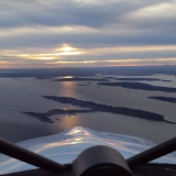
Maule MXT-7-180A
Sun Sep 29, 2013 5:27 pm
Re: Southwest Alaska Flying
Hey Troy, you know, I'm a photographer, and you sure take some awesome pix! Keep them coming!!
Eduardo
Eduardo
Mon Oct 21, 2013 9:16 am
Re: Southwest Alaska Flying
Didn't have my camera yesterday...but the cell phone managed to capture these...


- Troy Hamon offline
- Posts: 913
- Joined: Tue Apr 06, 2010 8:27 am
- Location: King Salmon
- FindMeSpot URL: http://share.findmespot.com/shared/face ... 04iX0FXjV2
- Aircraft: Piper PA-22
DISPLAY OPTIONS
Who is online
Users browsing this forum: No registered users and 12 guests
Latest Features
-
Live to Tell
A Minnesota pilot is surprised to learn that the sudden asymmetric drag of an out-of-rig ski can…Read More -
Creators
Working in some of the Yukon's most beautiful and remote environments, photographer Simon Blakesley captures aircraft in…Read More -
Aircraft Ownership and Maintenance
Upgrading to big tires can make a huge difference in backcountry performance, but with those gains come…Read More -
Tales from Yesteryear
In this tale from bush flying yesteryear, Don Cogger signs up to help Atlee Dodge Jr recovery…Read More


Latest Knowledge Base
-
Destinations
A regional guide with ideas for winter camping destinations in California, Nevada, New Mexico, and Arizona.Read More -
Aircraft
Finding an affordable aircraft that can handle the backcountry for $80K or less? A challenge for sure, but with the…Read More -
Aircraft
01.29.2018 - Zane - Updated tire diameter graphic to add 8.50x10 Guide to tires for use in the backcountry and off-airport landing…Read More -
Pilots
12.22.2013 - Initial article format Operating aircraft on skis and negotiating a snow-covered landscape is an entirely unique skillset and environment.…Read More


