I found the site and the news story. You would have thought they would have publicized this more. The site is Tomnod...and it appears the images are from DigitalGlobe.
http://www.ksl.com/?nid=148&sid=27930590
Here is a link to the search.
http://new.tomnod.com/nod/challenge/idsar2013
Facebook page too. Latest imagery isn't that great.
https://www.facebook.com/Tomnod
One missing near Johnson Crk/Yellow Pine
Tue Dec 10, 2013 5:26 pm
- Grassstrippilot offline


- Posts: 3536
- Joined: Wed May 31, 2006 6:17 am
- Location: Syracuse, UT
- FindMeSpot URL: https://share.garmin.com/WolfAdventures
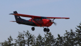
- Aircraft: Cessna 205
Tue Dec 10, 2013 8:02 pm
Re: One missing near Johnson Crk/Yellow Pine
I agree Cory, the images aren't that good. 
- piperpainter offline
- Posts: 968
- Joined: Sat Nov 29, 2008 10:57 pm
- Location: Auburn, WA
- Aircraft: C-205
Was Backcountry Mooney M20C
Tue Dec 10, 2013 9:05 pm
Re: One missing near Johnson Crk/Yellow Pine
DCO-65 wrote:Re: One missing near Johnson Crk/Yellow Pine
Is there any such thing as a large metal detector to hang from a helicopter?
Isn't that kind of how the Navy's P-3's go looking for subs?
It's called "Magnetic Anomaly Detection". Since it detects disturbances to the earths magnetic field, ie: ferrous metals, and very little of most airplanes is made from ferrous metals, I doubt it would be very effective in locating a downed airplane.
Submarines and mineable deposits are pretty huge, compared to an airplanes landing gear......
And, by the way, P-3 s can't find submarines for squat using just MAD. Actually, they generally can't find submarines.
MTV

Tue Dec 10, 2013 9:53 pm
Re: One missing near Johnson Crk/Yellow Pine
I don't know, even at the best of conditions, if anything could be spotted on the ground ticking along at that speed and altitude. In terrain like that what's needed is the area to be immediately saturated with slower light aircraft flying as low as practical and equipped with real time gps tracking data sent back to a command center. Unfortunately too late now. No point endangering life and machine trying to find corpses.
As for the blurred images, rather pointless, but the Family is desperate by now. They are willing to try anything. We all would.
As for the blurred images, rather pointless, but the Family is desperate by now. They are willing to try anything. We all would.
- Sidewinder offline
- Posts: 340
- Joined: Mon Sep 30, 2013 5:07 pm
- Location: SouthWest Kanada eh?
Wed Dec 11, 2013 7:32 am
Re: One missing near Johnson Crk/Yellow Pine
Sidewinder wrote:As for the blurred images, rather pointless, but the Family is desperate by now. They are willing to try anything. We all would.
Agreed. Nonetheless, I spent an hour last night looking for the needle just in case.
- rw2 offline

- Posts: 1799
- Joined: Sat Dec 22, 2012 1:10 pm
- Location: San Miguel de Allende
- FindMeSpot URL: https://share.delorme.com/LaNaranjaDanzante
- Aircraft: Experimental Maule
Follow my Flying, Cooking and Camping adventures at RichWellner.com
Wed Dec 11, 2013 8:28 am
Re: One missing near Johnson Crk/Yellow Pine
Me too, It was painful - no points of reference to get your bearings. They should overlay the radar returns, the roads, the stibnite mine, JC so you can get a sense of where you are and where you want to look. Some of the sections were so screwed up it is impossilbe to make out trees even.
- soyAnarchisto offline

- Posts: 1975
- Joined: Fri Aug 19, 2011 1:23 pm
- Location: Boulder, CO
- Aircraft: 1955 Cessna 180
Wed Dec 11, 2013 9:29 am
Re: One missing near Johnson Crk/Yellow Pine
Me too. I spent an hour finding Johnson Creek and Stibnite because I want to search the area the ear witness reported. Sure wish the images were better but I'm going to keep looking.

Wed Dec 11, 2013 9:57 am
Re: One missing near Johnson Crk/Yellow Pine
During the infamous Steve Fossett search a few years back, there was actually an organized "crowdsourced" satellite imagery search. I think they used the Amazon Mechanical Turk to distribute the assignments, and it allowed you to download the latest 1 day old sat imagery into Google Earth, pore over your assigned sector, and report any findings. People across the world were searching from the comfort of their IKEA Pöang chairs, but in the end it was some ATV dude who found the wreckage.
- Zzz offline


- Posts: 2854
- Joined: Fri Oct 08, 2004 11:09 pm
- Location: northern
- Aircraft: Swiveling desk chair
Half a century spent proving “it is better to be thought a fool than to open your mouth and remove all doubt.”
Wed Dec 11, 2013 10:17 am
Re: One missing near Johnson Crk/Yellow Pine
Zzz wrote:People across the world were searching from the comfort of their IKEA Pöang chairs
What a highly specific reference...
I like it!
- rw2 offline
- Posts: 1799
- Joined: Sat Dec 22, 2012 1:10 pm
- Location: San Miguel de Allende
- FindMeSpot URL: https://share.delorme.com/LaNaranjaDanzante
- Aircraft: Experimental Maule
Follow my Flying, Cooking and Camping adventures at RichWellner.com
Wed Dec 11, 2013 12:22 pm

- OregonMaule offline

- Posts: 6977
- Joined: Fri Sep 01, 2006 9:44 pm
- Location: Orygun
My SPOT page
"They who can give up essential liberty to obtain a little temporary safety, deserve neither liberty nor safety". Ben Franklin
http://en.wikiquote.org/wiki/Benjamin_Franklin
"They who can give up essential liberty to obtain a little temporary safety, deserve neither liberty nor safety". Ben Franklin
http://en.wikiquote.org/wiki/Benjamin_Franklin
Wed Dec 11, 2013 6:45 pm
Re: One missing near Johnson Crk/Yellow Pine
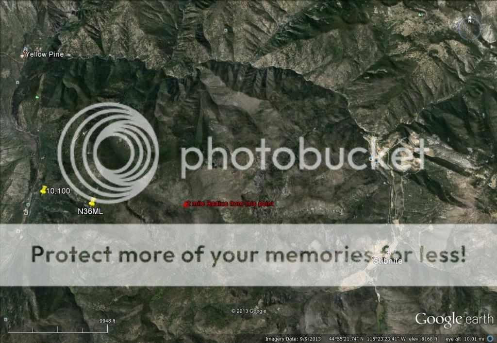
I believe most of the terrain between JC/Yellow Pine and Stibnite is pretty densely wooded! Plane could be deep in the trees at ground level.
But, if the plane went straight in nose first, maybe look real hard for a hole/broken branches in the trees? I dunno. Just thinking.
Also, while trucking along these snowy highways, I've noticed that Black Crows are about the only birds munching on road kill. Black Crows are easy to spot in white snow. So if anybody see's a flock of crows flying around a certain spot, investigate that area very well! Just another crazy idea, I know.
Sure there's always hope to get closure sooner and I really feel bad for the family. But reality is that the search may have to wait for spring. But doesn't hurt to keep flying over the area on nice days.

Wed Dec 11, 2013 10:27 pm
Re: One missing near Johnson Crk/Yellow Pine
I have been doing some more thinking. This is just my opinion. I looked at last reported altitude on radar, possible decent rate, last reported ground speed, possible direction of flight path, and elevation of the terrain.
God forbid we should ever be twenty years without a rebellion. ***Thomas Jefferson***
"The tree of liberty must be refreshed from time to time with the blood of patriots and tyrants." **Thomas Jefferson**
"The tree of liberty must be refreshed from time to time with the blood of patriots and tyrants." **Thomas Jefferson**
Thu Dec 12, 2013 12:09 am
Re: One missing near Johnson Crk/Yellow Pine
With out digging back ony iPhone, what again did the ear witness say he heard? Did he hear what he believed was the actual impact with terrain noise. Or over flying or near Sibnite with engine trouble? I think I heard both in separate posts here. Sure would be nice to hear the exact details from the ear witness.
Man, sure wish I can help!
Man, sure wish I can help!
Thu Dec 12, 2013 12:13 am
Re: One missing near Johnson Crk/Yellow Pine
pif_sonic wrote:I have been doing some more thinking. This is just my opinion. I looked at last reported altitude on radar, possible decent rate, last reported ground speed, possible direction of flight path, and elevation of the terrain.
I think that's a pretty good area to start to look!! I think I remember seeing in the video the ear witness kinda pointing in that general area where he heard the noise from.
I think you on to something, Pif Sonic!
Thu Dec 12, 2013 2:55 am
Re: One missing near Johnson Crk/Yellow Pine
It's a bit perplexing. According to the time and altitude charts here http://aireform.com/ntsb-fatal-accidents-a-page-with-further-inforecordslinks/fatal-aviation-accidents-2013q4/bonanza-n36ml-reported-lost-in-the-idaho-mountains-with-5-on-board-12113-12-noon/ The trouble started at 2:55 and terminated around 3:02. 7 min, averaging a speed of 180 mph and only losing 3000' He could travel 21 miles with altitude to spare. Could have possibly have made it back to McCall, but that's a mute point now.
He was an experienced IFR pilot. His instrumentation would have told him he was crossing just North of mid field at JC. Makes no sense why he would continue straight into no mans land. Judging by the pins posted by Pif-sonic it appears that he may have been initiating a turn to the South to perhaps setup an approach into the South end of JC increasing his decent rate to lose altitude. Unfortunately there are two ridges he would have to clear. The one close to his last tracked position, could have cleared, but at the last rate of decent reported. he would have Surly hit the one 2 miles to the South. For anyone going out that way it might be worth a look over.
I know everyone hates conjecture, but unfortunately that's all we got for now .For those of us on here who are capable of accessing the area and willing to put in a little time looking. It might help narrow down a search area a little, if we could somehow get inside the pilots head and ask ourselves, what would we do at that time, knowing we were crossing over a strip in a narrow valley 5000' below us, with shit visibility and no engine. Besides mercilessly shitting ourselves.
- Sidewinder offline
- Posts: 340
- Joined: Mon Sep 30, 2013 5:07 pm
- Location: SouthWest Kanada eh?
Thu Dec 12, 2013 7:47 am
Re: One missing near Johnson Crk/Yellow Pine
Everybody keeps reporting engine trouble, I don't think that was the root problem. I believe he picked up ice and was in a mandatory controlled descent while IMC. This could have added to the issue of vision even if he was to break out of the clouds before impact in that the windshield may have been iced over as well.
Looking at the speeds and descent rates I think it's fairly evident that he had power to me. Certainly not trimmed for best glide and windmilling.
On another note I have effected change in the interest of being able to be part of the solution in the future. I contacted Dan at ITD-Aeronautics and asked to be added to the SAR volunteer pilot list. He was very accommodating and informative about how SAR works in Idaho. I was cc'd in an email that went to my district coordinator asking that I be added. Last night I received an email from my district coordinator (NOT CAP, a county sheriff that happens to fly) with a pilot history form attached. I will have to attend training in Montana next October in order to go out on a search. They are also considering beginning a SAR training program right here in Idaho in the future. Again, although CAP is certainly involved in searches in Idaho, ITD-Aero is the point on the operation and the main coordinator of asset usage.
All seemed very cordial, inviting, and professional to me to this point but clearly these PRIOR preparatory steps are necessary if I expect to be allowed in later when something actually happens.
- lowflyinG3 offline

- Posts: 534
- Joined: Tue Dec 13, 2005 8:23 am
- Location: Gooding,Idaho
If you're not scarin' yourself, you're not scarin' the crowd!
Thu Dec 12, 2013 8:05 am
Re: One missing near Johnson Crk/Yellow Pine
2 more thoughts:
If he was picking up ice - the initial descent rates would have rapidly accelerated as ice built up.
Perhaps he was setting up for a circling descent to JC?
I too wonder why he would have flown over midfield. I'd also like to know what information ATC gave him. I understand he asked for coordinates of JC. If that's true - he didn't have a GPS on board? Or one with current airstrips in it? If he had a GPS but not the JC airport - putting in those coordinates - if he was able to write them down - manually in the stress of the situation would seem impossible to me.
Is there a recording of the known ATC communication?
- soyAnarchisto offline
- Posts: 1975
- Joined: Fri Aug 19, 2011 1:23 pm
- Location: Boulder, CO
- Aircraft: 1955 Cessna 180
Thu Dec 12, 2013 9:42 am
Re: One missing near Johnson Crk/Yellow Pine
I need to run out to the airport today or tomorrow, so I'll see if my 430W's database includes 3U2--but I'll be surprised if it does. Although it shows on the sectional, it does not show on the L chart (many VFR-only airports are purposely omitted from L charts).
I'm still puzzled that I cannot find any California pilots named Dale Smith in the FAA's data base who have anything other than private licenses without instrument ratings, except for one ATP who is pretty clearly an airline pilot and whose address doesn't at all match with the address of the owner of the subject Bonanza. Very curious.
At this stage, though, it would be a mistake to think that anyone could still be alive. It's one thing to survive in rugged country in the summer time; it's another altogether different thing in bitter cold wintry weather, this long after the disappearance. It would not be good to risk others in any hope of finding survivors.
Cary

"I have slipped the surly bonds of earth..., put out my hand and touched the face of God." J.G. Magee
Thu Dec 12, 2013 11:50 am
Re: One missing near Johnson Crk/Yellow Pine
Cary: 3U2 is on the 430W
- OregonMaule offline
- Posts: 6977
- Joined: Fri Sep 01, 2006 9:44 pm
- Location: Orygun
My SPOT page
"They who can give up essential liberty to obtain a little temporary safety, deserve neither liberty nor safety". Ben Franklin
http://en.wikiquote.org/wiki/Benjamin_Franklin
"They who can give up essential liberty to obtain a little temporary safety, deserve neither liberty nor safety". Ben Franklin
http://en.wikiquote.org/wiki/Benjamin_Franklin
Thu Dec 12, 2013 12:35 pm
Re: One missing near Johnson Crk/Yellow Pine
Did this plane have a 430 on it? If he was IFR rated - would he be flying only w/ the low altitude charts and not a VFR sectional?
Perhaps he is a Montana pilot? Is Dale a middle name?
Perhaps he is a Montana pilot? Is Dale a middle name?
- soyAnarchisto offline
- Posts: 1975
- Joined: Fri Aug 19, 2011 1:23 pm
- Location: Boulder, CO
- Aircraft: 1955 Cessna 180
DISPLAY OPTIONS
Who is online
Users browsing this forum: No registered users and 0 guests
Latest Features
-
Live to Tell
A Minnesota pilot is surprised to learn that the sudden asymmetric drag of an out-of-rig ski can…Read More -
Creators
Working in some of the Yukon's most beautiful and remote environments, photographer Simon Blakesley captures aircraft in…Read More -
Aircraft Ownership and Maintenance
Upgrading to big tires can make a huge difference in backcountry performance, but with those gains come…Read More -
Tales from Yesteryear
In this tale from bush flying yesteryear, Don Cogger signs up to help Atlee Dodge Jr recovery…Read More


Latest Knowledge Base
-
Destinations
A regional guide with ideas for winter camping destinations in California, Nevada, New Mexico, and Arizona.Read More -
Aircraft
Finding an affordable aircraft that can handle the backcountry for $80K or less? A challenge for sure, but with the…Read More -
Aircraft
01.29.2018 - Zane - Updated tire diameter graphic to add 8.50x10 Guide to tires for use in the backcountry and off-airport landing…Read More -
Pilots
12.22.2013 - Initial article format Operating aircraft on skis and negotiating a snow-covered landscape is an entirely unique skillset and environment.…Read More


